2017 January
Day trip:
- Climb Mt Roland
- Climb Mt Vandyke
- Pass by Mt Claude
- Climb Mt Claude Lookout
in Tasmania, Australia
Prolog
Tasmania is such a wonderful place for hiking that I'm back here again to climb some more mountains. This trip is to Mt Roland, Mt Vandyke, Mt Claude and Mt Claude Lookout.
- Mt Roland, 1233 meters
I start out from a small carpark by the side of Kings Road. There is a well defined track to the summit, called Face Track ... pretty straight forward.
There are plenty of warnings on the web about the steepness and danger of the Face Track. Steep? Yes. But danger? Nah! :-)
- Mt Vandyke, 1084 meters
The final scramble up the boulders to the summit is steep and exposed. If you have a better way to climb it, let me know. Perhaps it can be recorded here to help others. (Refer to photos #36, #38 and #40 for climbing up its summit.)
- Mt Claude, 1034 meters
I didn't do my research properly on Mt Claude. I thought at the point of the closest approach to the mountain, I can simply go off track to climb it. Well, it is not so simple. And so, I couldn't manage to reach its summit :-(
2 years later, in 2019 February, I'll be back here again to climb Mt Claude ... successfully :-)
Instructions on how to reach its summit, plus photographs and trip report are in my blog:
https://mntviews.blogspot.com/2019/02/mt-claude-mt-claude-lookout-tas.html
- Mt Claude Lookout, 1010 meters approx
A hill near Mt Claude with a wonderful view to all the places I've been today.
Map
TASMAP Cethana (1:25,000)
The map below is from OpenSteetMap:
- Red oval: The town of Gowrie Park
- The 6 red arrows point to, anti-clockwise from bottom left corner:
1 Round Mountain Lookout
2 Mt Claude Lookout
3 3-way junction ... to Mt Roland, to Mt Vandyke and to O'Neills Road at Gowrie Park ... See photo #33.
4 Rest area with a triangular platform and a triangular table ... See photo #30.
5 Small carpark on the east side of Kings Road ... where I park my car and start the walk ... See photo #2.
6 Junction of Claude Road and Kings Road

GPS tracklog file & route
The GPX tracklog file of this trip can be downloaded from:
https://drive.google.com/file/d/1G18EJOase3ehuFQydaZnmB805iMavPQ7/view?usp=sharing
Below is the same tracklog, brown colour, clockwise direction, superimposed on OpenStreetMap:
- Red oval: The town of Gowrie Park
- The 6 red arrows point to, anti-clockwise from bottom left corner:
1 Round Mountain Lookout
2 Mt Claude Lookout
3 3-way junction ... to Mt Roland, to Mt Vandyke and to O'Neills Road at Gowrie Park ... see photo #33.
4 Rest area with a triangular platform and a triangular table ... see photo #30.
5 Small carpark on the east side of Kings Road ... where I park my car and start the walk ... See photo #2.
6 Junction of Claude Road and Kings Road

Satellite image of the tracklog:

In summary, my route is:
- Start at a small carpark on Kings Road
- Walk on Face Track to Mt Roland summit
- Then to Mt Vandyke summit
- Walk over a 971-meter peak marked in OpenStreetMap as Fossey Mountains
- Pass by the base of Mt Claude
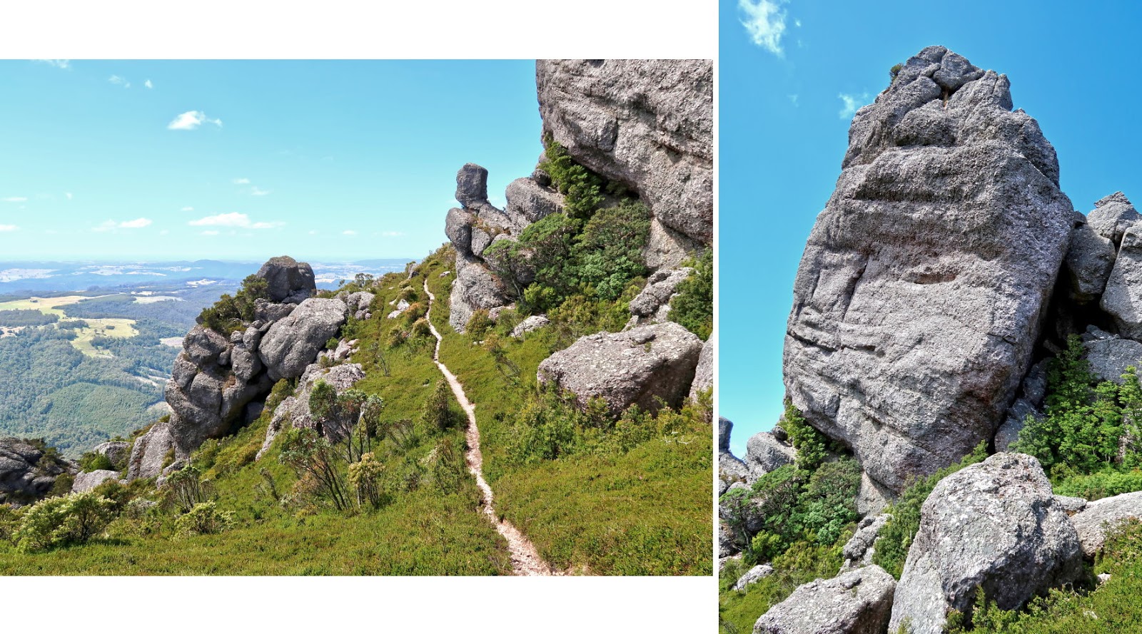
- Climb to the top of Mt Claude Lookout
- To Round Mountain Lookout
- Walk on Olivers Rd, Claude Rd, Kings Rd back to the small carpark
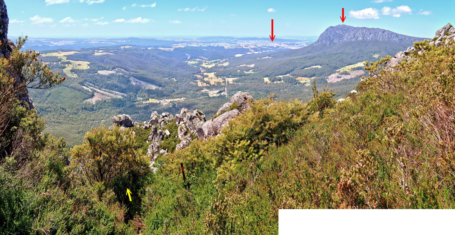
Timeline & Distance
06:49 0.0 km Start at a small carpark on Kings Road
09:23 4.0 km At Mt Roland summit
09:36 4.0 km Leave Mt Roland summit
10:20 6.0 km At a rest area with a triangle table on a triangle platform
10:21 6.0 km Leave rest area
10:32 6.8 km At 3-way junction of Mt Roland Plateau Trail, Mt Vandyke Trail & trail to O'Neills Rd
11:01 8.2 km At junction of access trail to climb Mt Vandyke
11:16 8.6 km At Mt Vandyke summit
11:20 8.6 km Leave Mt Vandyke summit
11:44 9.0 km Back at junction of access trail to climb Mt Vandyke, same spot as at 11:01
12:13 10.4 km Stop for lunch
Lunch
12:28 10.4 km Resume walking
13:37 13.0 km At 971-meter peak marked in OpenStreetMap as Fossey Mountains
13:49 13.0 km Leave Fossey Mountains
14:52 15.1 km At the closest approach to Mt Claude summit
Leave trail (called Mt Claude Traverse Track), to try to climb up Mt Claude.
Give up ... the thicket is almost impenetrable.
15:07 15.3 km Back at Mt Claude Traverse Track
15:17 15.8 km At junction of access trail to Mt Claude Lookout
15:29 16.0 km At the top of Mt Claude Lookout
15:32 16.0 km Leave the top of Mt Claude Lookout
15:35 16.0 km Stop for 1st afternoon tea
1st afternoon tea
15:46 16.0 km Resume walking
15:49 16.2 km Back at junction of access trail to Mt Claude Lookout, same spot as at 15:17
16:19 18.5 km At Round Mountain Lookout, at the junction of Mt Claude Lookout Track and Olivers Rd
Take photos
16:23 18.7 km Resume walking
16:57 22.0 km At junction of Olivers Rd & Claude Rd
18:22 28.6 km Stop for 2nd afternoon tea
2nd afternoon tea
18:29 28.6 km Resume walking
19:09 31.7 km At junction of Claude Rd & Kings Rd
19:31 33.0 km Back at the small carpark on Kings Road
==============================================
Total: 12 hrs 42 mins
33.0 km Distance is from Google Earth
36.7 km Distance is from Garmin GPS
Pictures: Early morning - driving to carpark on Kings Road
1) Mt Roland ... This pic is taken while driving on Kings Road, not far from the junction with Claude Road.
It is very early in the morning, before sunrise, still quite dark.
- Red arrow: Mt Roland summit
- Yellow arrows: Face Track, the route to climb Mt Roland

Carpark by the side of Kings Road
2) At a small carpark for the Mt Roland climb ... on the east side of Kings Road ~~~
- This is the rental car for the duration of my stay in Tasmania.
- Blue sign by the side of the car: Says "Car Park".
- Blue sign behind the car: Says "Track" (ie Face Track to Mt Roland).

Climb Mt Roland along Face Track
3) The earlier part of Face Track to Mt Roland ~~~
- Lower pic: A good looking cairn :-)

4) Plenty of Tea Trees along the route ... It is Leptospermum, but which species?

5) I am about halfway up the slope of Mt Roland and looking down ... north-ish.
- Yellow arrow on the left: Along Claude Road ... it runs horizontally across the pic.
- Yellow dot: Junction of Claude Road and Kings Road
- Yellow arrows on the right: Along Kings Road
- Red dot: Where my rental car is parked. (The car can't be seen from here as it is behind the trees.)
- In the late afternoon, I will walk from the left side of the pic, along Claude Road, then along Kings Road back to the car.
- This morning, I drove from the right side of the pic, along Claude Road, then along Kings Road to where the car is now.
- The town of Sheffield is well beyond the right edge of this pic.

6) Orange/red mushrooms ~~~
The one on the right is probably a different species from the ones on the left.

7) The higher part of the climb along Face Track on the slope of Mt Roland is along these gravels in a dry rocky gully.
- Red arrow: I'm heading there.

8) Looking back down slope at the dry rocky gully.

9) Cliffs lining the gully ~~~
- Red arrow: I'm heading there.

10) Almost at Mt Roland plateau ~~~
I'll get onto the plateau somewhere on the flat ridge area on the left side of this pic.
(To enlarge the image, click on it.)

11) At the same spot as the previous pic ... looking down the gully where I climbed up from:
- Red dot: Junction of Claude Road and Kings Road
- Red arrow left of the dot: Along Claude Road ... it runs horizontally across the pic.
- Red arrow below the dot: Along Kings Road
- In the late afternoon, I will walk along Claude Road (from left to right), then along Kings Road back to the car.
- This morning, I drove from the right side of the pic, along Claude Road, then along Kings Road to where the car is parked.

Mt Roland plateau
12) Scenery at Mt Roland plateau ~~~
Continuation to the right of this pic is photo #13 ... together they form a 270-degree panorama.

13) The 3 pics below and the previous pic form a 270-degree panorama.
- Upper pic: (Continuation to the right of previous pic)
• What a typical track looks like around this part of the plateau
• Yellow arrows: I am heading towards the gap there.
- Middle pic: (Continuation to the right of the upper pic)
- Lower pic: (Continuation to the right of the middle pic)
• Red arrow: I climbed up from the gap there. The gully of photo #11 is just behind the gap.

14) Now climbing up along the upper yellow arrow in photo #13

15) Christmas Bells (Blandfordia nobilis) ... They are beautiful.

16) (To enlarge the image, click on it.)
This is the scenery greeting me after climbing to the top of the slope in photo #14.
- Mt Roland cannot be seen yet.
- The direction I'm heading is through the gap in the middle of the pic.

17) Further along the plateau ~~~
- Upper pic:
• Red arrow on the left edge: I came from there.
- Lower pic: (Continuation to the right of the upper pic)
• Red arrow: I'm heading towards the gap there.

Mt Roland summit
18) After passing through the gap of the previous pic, I finally get to see the summit of Mt Roland and its trig.

19) Almost at the summit of Mt Roland

20) A selfie at the summit of Mt Roland, 1233 meters ~~~
It is a very windy day and I almost can't hold the selfie stick steady.

Panorama from Mt Roland summit
21) Scenery from the summit of Mt Roland ~~~
- Continuation to the right of this pic is photo #22 ... together they form a 360-degree panorama.
- Red arrow: The town of Sheffield ... towards north-north-east-ish

22) The 3 pics below plus the previous pic form a 360-degree panorama.
- Upper pic: (Continuation to the right of the previous pic)
• Red arrow: Legges Tor ... towards east-ish
- Middle pic: (Continuation to the right of the upper pic)
• The 4 red arrows point to, from left to right:
1 Mt Vandyke
2 971-meter peak marked in OpenStreetMap as Fossey Mountains ... towards south-west
3 Mt Claude
4 Mt Claude Lookout
• Yellows arrows: My route to visit all the above 4 peaks
• See also photo #23 which zooms into parts of this pic.
- Lower pic: (Continuation to the right of the middle pic)
- Continuation to the right of the lower pic is photo #21, thus completing a 360-degree panorama.

23) Zooming into the arrows in the middle pic of photo #22 ~~~
In a good day, you should be able to see some of the iconic mountains of Tasmania, like Mt Ossa, Cradle Mountain, Barn Bluff etc. But not today, too cloudy.
- The 9 red arrows point to, from left to right:
1 Mt Vandyke
2 Mt Pelion East ... obscured by clouds
3 Mt Ossa ... obscured by clouds
4 Mt Pelion West ... obscured by clouds
5 Barn Bluff ... obscured by clouds (To the immediate left of Barn Bluff is Mt Emmett.)
6 Cradle Mountain ... obscured by clouds
7 971-meter peak marked in OpenStreetMap as Fossey Mountains ... towards south-west
8 Mt Claude
9 Mt Claude Lookout
- Yellows arrows: My route to visit Mt Vandyke and the above 3 peaks

Climb down Mt Roland
24) I am climbing down from the summit of Mt Roland.
- The summit is behind me.
- Yellow arrows: Foot track to Mt Vandyke ... That is where I'm going now.
- Red Square: 3 way junction with sign posts and map
- Turquoise arrow: Foot track to carpark at Kings Road
- Red oval: At the back of these rocks is another foot track leading to the summit of Mt Roland. I walked on there not too long ago.

To Mt Vandyke
25) This scene is just after passing the signage in the red square of the previous pic ... just a few meters into the foot track to Mt Vandyke.
- Red arrow: Mt Vandyke ... I'm heading there to climb it.

26) Looking back at Mt Roland ... Wild flowers carpet the plateau.
- Upper pic:
• Red oval: The summit is somewhere behind there. It can't be seen from where I'm standing.
• Yellow arrow: The foot track from Mt Roland
- Lower pic: Further away from the mountain
• Red arrow: One can just make out the summit trig.
• Yellow arrows: The foot track from Mt Roland

27) (At the same spot as where the previous pic was taken)
Looking at where I'll be going ~~~
- The 4 red arrows point to, from left to right:
1 Mt Vandyke ... I'm heading there to climb it.
2 971-meter peak marked in OpenStreetMap as Fossey Mountains
3 Mt Claude
4 Mt Claude Lookout
- Yellows arrows: The foot track to all the above 4 mountains
- Red oval: The route goes to the left and behind these rocks.

28) Looking back at Mt Roland ~~~
- Red arrow: One can just make out the summit trig.
- Yellow arrows: The foot track from Mt Roland

29) Condition of the foot track on Mt Roland plateau ~~~
- Some sections have boards, like the right pic.
- Some sections are very wet, like the left pic. There was some rain the day before, but I suspect some puddles along the track are more or less permanently. Because hikers, in an attempt to keep their boots dry, have trampled out separate trails through the vegetation around the puddles. The Tasmania Parks and Wildlife Services really should construct a board walk over the waters.

30) I come to this viewing platform - roughly halfway between Mt Roland summit and Mt Vandyke.

31) Scenery from the above viewing platform:
- Red arrow: Legges Tor, 2nd highest mountain in Tasmania, toward east-ish
- The centre of this pic is towards south-east.

32) In the previous pic, the view to Mt Vandyke from the viewing platform is obstructed by too many trees. But if you leave the viewing platform and move forward, you'll soon get a good view, like this pic.
- Red arrow: Mt Vandyke
- Yellow arrows: Route to climb Mt Vandyke

33) Now at a 3-way junction:
- One track goes to Mt Vandyke ... directly forward.
- One track goes to Mt Roland.
- One track goes down to O'Neills Road at Gowrie Park ... towards the right side of the pic.
The sign says:
- Mt Vandyke 1 hr ... I'll be at its summit 44 minutes later :-)
- Mt Roland 1.5 hrs ... I came from Mt Roland summit 56 minutes ago :-)

34) Walking further along towards Mt Vandyke and looking back at Mt Roland, the red arrow

35) Closer and closer to Mt Vandyke

To Mt Vandyke summit
36) Mt Vandyke ~~~
- Red oval: Mt Vandyke ... The lower pic zooms onto it.
- Left red arrow: Mt Vandyke summit
- Right red arrows Points to the top of the saddle between the two separate piles of boulders.
- Yellow arrow: Foot track (which branches off from the main trail) leading to the top of the saddle
- I'll walk along the foot track towards the top of the saddle, then go off-track (turn left) to climb up the summit. The foot track seems to keep going down the saddle. I don't know to where. The way I'll climb towards the summit is not easy ... quite steep and exposed.
- If you know where the foot track leads to, please let me know ... I'm curious.

37) Approaching closer towards the previous pic ~~~
You should be able to match some of the boulders in this pic with the boulders in the previous pic.

38) (This pic and the ones in photo #39 form an almost 360-degree panorama.)
I am now at the top of the saddle ... at the right red arrow of photo #36.
- The summit of Mt Vandyke is somewhere up there in this pic.
- Yellow arrow: The way I go scrubbashing up towards the summit.
- The pile of boulders here is the same pile of boulders on the right side of the previous pic.
- You should be able to match some of the boulders in this pic with the boulders in the previous pic :-)
- Continuation to the right of this pic is photo #39.

As mentioned in the previous pic, the yellow arrow is how I scrubbash up towards the summit. And as it will be mentioned in photo #40, it is quite steep and exposed while climbing up the boulders. Now, how did you climb up Mt Vandyke? I would really like to read about your experience; and perhaps record them here to help others to climb to the summit.
39) (Continuation to the right of the previous pic)
- Upper pic:
• Yellow arrow: As mentioned in the comments to photo #36, the foot track keeps going ... to where I don't know.
- Lower pic: Continuation to the right of the upper pic
• Interesting pile of boulders.
- To the right of the lower pic is the foot track where I just walked on to here (not shown here). And to the right of the foot track is photo #38.

Climb up towards Mt Vandyke summit
40) I am almost at Mt Vandyke summit ... It is somewhere up there in this pic.
- There is no trig nor cairn at the summit.
- You should be able to match some of the boulders in this pic with the boulders in photo #38 :-)
- Red oval: Same boulder as the one in photo #44's red circle
- It is steep and exposed to climb up to this point. Today happens to be a very windy day too. I was quite scared to be blown off the boulders while climbing up.

Panorama from Mt Vandyke summit
Finally, I am at the summit of Mt Vandyke, 1084 meters.
No selfie of myself as it is too windy to hold a selfie stick here :-(
41) This pic and photo #42 form a 360-degree panorama.
- Red arrow: Mt Roland ... towards north
- Yellow arrows: The route from Mt Roland to Mt Vandyke
- Continuation to the right of this pic is photo #42.

42) The 3 pics below plus the previous pic form a 360-degree panorama.
- Upper pic: (Continuation to the right of the previous pic)
• Red arrow: Legges Tor ... towards east-ish
- Middle pic: (Continuation to the right of the upper pic)
• Photo #43 zooms into right half of this pic.
• The 5 red arrows point to, from left to right:
1 Mt Pelion East ... on the far horizon, too cloudy to see it properly
2 Mt Ossa ... on the far horizon, too cloudy to see it properly
3 Mt Peilon West ... on the far horizon
4 Barn Bluff (To the immediate left of Barn Bluff is Mt Emmett.)
5 Cradle Mountain ... towards south-west-ish
- Lower pic: (Continuation to the right of the middle pic)
• Photo #43's lower pic zooms into left side of this pic.
• The 2 red arrows point to, from left to right:
1 Unnamed rocky hill ... The track to Mt Claude goes around its left side and then behind it.
2 Mt Claude
- Continuation to the right of the lower pic is photo #41, thus completing a 360-degree panorama.

43) Zooming into parts of photo #42 ~~~
- Upper pic: (Right half of photo #42's middle pic)
• The 6 red arrows point to, from left to right:
1 Mt Pelion East ... on the far horizon, too cloudy to see it properly
2 Mt Ossa ... on the far horizon, too cloudy to see it properly
3 Mt Peilon West ... on the far horizon
4 Mt Emmett
5 Barn Bluff
6 Cradle Mountain ... towards south-west-ish
- Lower pic: (Continuation to the right of the upper pic)
• The 5 red arrows point to, from left to right:
1 Mt Emmett
2 Barn Bluff
3 Cradle Mountain ... towards south-west-ish
4 Unnamed rocky hill ... The track to Mt Claude goes around its left side and then behind it.
5 Mt Claude
• Yellow dots: The track to Mt Claude ... It goes from right to left, and then behind the unnamed rocky hill.

Climbing down Mt Vandyke summit
As mentioned in photo #40, it was extremely windy while scrambling up the boulders to the summit of Mt Vandyke. Thus now, climbing down the summit, I choose a different way down, away from the windy side. As a result, I end up circumnavigating almost the entire pile of boulders where the summit is :-) But the scrub around the bottom is very dense, not pleasant to bash through.
44) A few steps down Mt Vandyke summit and looking back at it ~~~
- Red circle: Same boulder as the one in photo #40's red oval

To 971-meter peak marked in OpenStreetMap as Fossey Mountains
Now to Mt Claude; but first, need to pass over a 971-meter peak marked in OpenStreetMap as Fossey Mountains.
45) While on my way, looking back at Mt Vandyke, the red arrow

46) The rounded rocky hill in the 3 pics below is the one pointed by the 4th red arrow in photo #43's lower pic.
- Middle pic:
• The 3 red arrows in the middle pic point to, from left to right:
1 Mt Emmett
2 Barn Bluff
3 Cradle Mountain ... towards south-west-ish
• Yellow arrow: Track to Mt Claude is to climb over the rocky hill along this arrow.

47) Passing by this interesting rock

48) If you know the name of this flower, please let me know.

49) Banksia ... but which species ?

50) This view is taken when crossing over the ridge of the rock hill in photo #46 (ie at the tip of the yellow arrow there).
- The 2 red arrows point to, from left to right:
1 Mt Claude
2 971-meter peak marked in OpenStreetMap as Fossey Mountains

51) The varied conditions of the foot track, called Mt Claude Traverse Track

At 971-meter peak marked in OpenStreetMap as Fossey Mountains
52) Scenery from the top of 971-meter peak marked in OpenStreetMap as Fossey Mountains
- Upper pic: Looking forward
• You can see the foot track going towards to Mt Claude, my next destination.
• The 2 red arrows point to, from left to right:
1 Mt Claude
2 Black Bluff
- Lower pic: Looking backward
• The 3 red arrows point to, from left to right:
1 Mt Roland
2 Mt Vandyke
3 Unnamed rocky hill in photo #46; same as the one pointed by the 4th red arrow in photo #43's lower pic
• Yellow arrow at bottom right hand corner: Foot track I walked on to here.
• Above the yellow arrow is a post to mark the foot track.
• Yellow dots: Route from Mt Vandyke to here ... It comes from behind the unnamed rocky hill (3rd red arrow).

53) Me ... It is very windy here (well, actually it is windy for the whole day); and I can hardly hold the selfie-stick steady to take this shot.
- The 2 red arrows point to, from left to right:
1 Mt Vandyke
2 Unnamed rocky hill in photo #46; same as the one pointed by the 4th red arrow in photo #43's lower pic

To Mt Claude
54) On the way to Mt Claude ~~~
- Upper pic: The 4 red arrows point to, from left to right:
1 Barn Bluff
2 ?
3 Cradle Mountain
4 Mt Claude
- Middle pic: The 2 red arrows point to, from left to right:
1 Unnamed peak in front of Mt Claude ... see the lower pic.
2 Mt Claude
- Lower pic: The peak here is the same as the first red arrow of the middle pic

55) Some one left a scarf here :-)

Mt Claude
56) (To enlarge the image, click on it.)
- Mt Claude is the mountain on the left side of the pic. Its summit is somewhere behind the top.
- The foot track, called Mt Claude Traverse Track, is on the right side of the pic. It will skirt around the far side of the mountain.

57) Further along the foot track, ie Mt Claude Traverse Track (To enlarge the image, click on it.) ~~~
- The cliffs of Mt Claude are on the left edge.
- Left red arrow: The town of Sheffield ... towards north-east-ish
- Right red arrow: Mt Roland
- Yellow arrow: The foot track goes along the arrow.
58) The cliffs of Mt Claude ~~~
- Lower pic: Photograph taken from near the closest approach on the foot track
• Yellow arrow at the bottom right hand corner: I'll attempt to climb up Mt Claude from there ... see photo #59.

I didn't do my research properly prior to the trip. I thought at the point of the closest approach to Mt Claude, I can simply go off track to climb it. Well, it is not so simple.
59) Chockstone of Mt Claude ~~~
This pic is taken at the base of the yellow arrow of the previous pic.
It is my attempt to climb to the summit of Mt Claude ... go off track towards this gap in the cliffs from near the closest approach. The off track bushbashing is atrocious; the scrub is almost impenetrable. When I reach the base of the gap in this pic, I find the scrub further upward is too thick for me to be able to scramble up.

So I give up and return to the foot track :-(
2 years later, in 2019 February, I'll be back here again to climb Mt Claude ... successfully :-)
Instructions on how to reach its summit, plus photographs and trip report are in my blog:
https://mntviews.blogspot.com/2019/02/mt-claude-mt-claude-lookout-tas.html
60) From where I was standing in the previous pic, looking down at the foot track ~~~
- Mt Claude Lookout is the hill on the right side of the pic. I'll be climbing it next.
- Red arrow: The rock here is the same as the one in photo #62.
- The foot track you can see here is Mt Claude Traverse Track.

61) Looking back at the foot track I had walked on
- Left pic: The foot track is Mt Claude Traverse Track.
- Right pic: (Continuation to the right of the left pic)
• Mt Claude summit should be just behind this big boulder.
To Mt Claude Lookout
62) Now going to Mt Claude Lookout ~~~
- Upper pic: Photograph taken a little earlier
• The large boulder behind the bush is the same boulder pointed by the red arrow in photo #60.
- Middle pic: Closer to the lookout
- Lower pic: You can see clearly the antenna at the top of the lookout.

63) Almost at the top of Mt Claude Lookout

At the top of Mt Claude Lookout
64) The 3 pics below together with photo #65 form a 360-degree panorama from the top of Mt Claude Lookout.
- Upper pic: (Continuation to the right of photo #65)
- Middle pic: (Continuation to the right of the upper pic)
• The 4 red arrows point to, from left to right:
1 The town of Sheffield ... towards north-east
2 Mt Roland
3 Mt Vandyke
4 Mt Claude
• Photo #66 zooms into the above 4 land marks.
- Lower pic: (Continuation to the right of the middle pic)
• The 2 red arrows point to, from left to right:
1 Mt Pelion West
2 Mt Emmett
- Continuation to the right of the lower pic is photo #65, thus completing a 360-degree panorama.

65) (Continuation to the right of previous pic)
- This is the top of the lookout, 1010 meters approx
- The 3 red arrows point to, from left to right:
1 Mt Emmett
2 Barn Bluff
3 Cradle Mountain

66) Zooming into the middle pic of photo #64 ~~~
Most satisfying is to look back at the places I've been today. Although I didn't reach the summit of Mt Claude, but one day I'll be back :-)
- The 4 red arrows point to, from left to right:
1 The town of Sheffield ... towards north-east
2 Mt Roland
3 Mt Vandyke
4 Mt Claude

67) Still at the top of Mt Claude Lookout ~~~
If you know its name of this white flower, please let me know.

Walking on Mt Claude Lookout Track to Round Mountain Lookout
68) After Mt Claude Lookout, the foot track changes its name from Mt Claude Traverse to Mt Claude Lookout Track. Here, I am walking towards an installation ... Can someone please tell me what is it for?
69) It looks like a transmission installation
70) Looking back at the transmission installation ~~~
In Google Maps, the road here is still called Mt Claude Lookout Track
71) Looking back at the transmission installation
At Round Mountain Lookout
Arrive at Round Mountain Lookout on Olivers Road, at the junction with Mt Claude Lookout Track
72) This pic and photo #73 form a 270-degree panorama from Round Mountain Lookout ~~~
(To enlarge the image, click on it.)
The 4 red arrows point to, from left to right:
1 630-meter hill west-south-west of the lookout
2 Black Bluff
3 East Black Bluff
4 610-meter hill north-west of the lookout

73) Continuation to the right of the previous pic: (To enlarge the image, click on it.)
The 2 red arrows point to, from left to right:
1 Mt Roland ... east-north-east-ish
2 Mt Vandyke ... east-ish, hidden behind the trees

Return to car - scenery along Claude Rd
Now, if there is a car shuffle, I could have hop into a car and drive back to the carpark at Kings Road. As is now, I have another 14.5 kilometers, a bit over 3 hours of walking on Olivers Road, then Claude Road, then Kings Road back to the car :-(
74) The 2 pics below form a 180-degree panorama taken from opposite 1469 Claude Road, Gowrie Park. Time now is 15:33; 11 hours 44 minutes, 24.7 kilometers after I started walking this morning. Although tired, it is most satisfying to be able to view the entire mountain range ... I had walked along its top for the whole today !
- Upper pic:
• The 2 red arrows point to, from left to right:
1 Mt Roland, the first peak I climbed this morning.
2 Mt Vandyke summit is behind the cliff and can't be seen from here.
• The route to climb up Mt Roland is behind the mountain and can't be seen from here.
• Yellow arrow: I'll walked along Claude Road in that direction back to the car.
- Lower pic: (Continuation to the right of the upper pic)
• The 4 red arrows point to, from left to right:
1 971-meter peak marked in OpenStreetMap as Fossey Mountains
2 Mt Claude ... blocked by the big tree :-( ... but see photo #75.
3 Mt Claude Lookout
4 Round Mountain Lookout ... photos #72 and #73 were taken from there.
• Yellow arrow: I have been walking along Claude Road to here.

75) This pic is taken from opposite 1467 Claude Rd, Gowrie Park (100 meters east of the previous pic).
(To enlarge the image, click on it.)
- Red circle: The sign says "Hydro Tasmania, The power of natural thinking".
- The building behind the red circle is the same building as in photo #74.
- The 5 red arrows point to, from left to right:
1 1467 Claude Rd, Gowrie Park
2 971-meter peak marked in OpenStreetMap as Fossey Mountains
3 Mt Claude ... a much better view of it than in the previous pic :-)
4 Mt Claude Lookout
5 Round Mountain Lookout ... photos #72 and #73 were taken from there.

76) At O'Neills Creek Picnic Reserve, 1416 Claude Rd, Gowrie Park ~~~
- Red arrow: Mt Roland ... The route to climb up Mt Roland is behind the mountain and can't be seen from here.

77) At 1369 Claude Rd, Gowrie Park (To enlarge the image, click on it.)
- Left red arrow: Mt Roland ... The route to climb up Mt Roland is behind the mountain and can't be seen from here.
- Right red arrow: Mt Vandyke summit is behind the cliff and can't be seen from here.

78) Typical Tasmania rural farm scene ~~~
(At 1290 Claude Rd, Gowrie Park)

79) A nice view of Mt Roland taken at 807 Claude Rd, between Wildlife Rd and Perkins Dr, and about 420 meters from the junction with Kings Road ~~~
- Red arrow: Mt Roland summit
- Yellow dot: Small carpark at Kings Road ... where my hire car is parked.
- Yellow arrows: Face track, the route to Mt Roland

Post Script - Climb Mt Claude
I climb Mt Claude successfully 2 years later in 2019 February.
Instructions on how to reach its summit, plus photographs and trip report are in my blog:
https://mntviews.blogspot.com/2019/02/mt-claude-mt-claude-lookout-tas.html
Wow I got tired just reading your account of this day climbing etc. Well done to cover all of that in one day. My main interest is photography not climbing as such. I really enjoyed viewing your photo portfolio of this trip. Did you see any snakes on Mt Roland?
ReplyDeleteI'm short-sighted and walk without glasses. If I walk by myself, like in this trip, I often miss out on interesting creatures, like snakes :-(
DeleteWow Paul fantastic detail well done.Mt.Claude is tougher than it looks.
ReplyDeleteMick