Climb Mt Razorback
5th highest mountain in NT, Australia

Mt Razorback is not the highest mountain in Australia. It is not even the highest mountain in NT. But of all the hikes I have done, this has to be rated as a one of the more memorable climbs.
What Mt Razorback lacks in height, it well and truly makes up in ... well see the photos ... !!!
Elevation:
Good question.
We know Mt Razorback is the 5th highest mountain in NT, otherwise Wikipedia has no information on it.
This is what I can gather from the web:
- 1262 meters - http://www.bonzle.com/c/a?a=f&sc=h&st=7&cmd=sp&mo=36728724 (This site also says Mt Zeil as 1,497m, whereas most sources give it as 1531m.)
- 1265 meters - My Garmin GPS
- 1258 meters - Google Earth
Map:
Google Earth/Map is probably the only source of a detailed map.
A screen print of it can be downloaded from:
https://docs.google.com/open?id=0B877-h5SCJaSLWxEaGd4czlGSWM
Hiking Route:
There is no trail to the summit. You have to find your own way.
Here is how we did it:
- KML file to and from summit, download from:
https://docs.google.com/open?id=0B877-h5SCJaSeEJYSExVY3hFTmc
A very interesting 3-km long narrow winding gorge is marked in the file.
- GPX file to the summit, download from:
https://docs.google.com/open?id=0B877-h5SCJaSek5Wb3Q5dHNxOEU
- GPX file return from summit, download from:
https://docs.google.com/open?id=0B877-h5SCJaSTG96QzBfSlYwajA
We parked the car about 600 meters west of Redbank Gorge carpark ... it was easier to hike from there than from the carpark. (Click on the following image to enlarge it, or better still, display the KML file in Google Earth.)

Distance & time:
Return trip is:
29 km
11 hrs 15 mins
The return leg of the trip was 5 hrs 30 minutes - longer than expected. The main reason being the 3-km long gorge was difficult to negotiate through. Many places required rock climbing ... climbing down cliffs which would have been waterfalls if there were water. I'm hopeless in rock climbing, hence the long time in getting through the gorge.
Water:
Typical of the arid region of Australia, the air was very dry. I carried 4.5 litres of water. Even with careful rationing, by the end of the day, I drank the lot. I could have easily gulped down 6 litres if I had carried that much water.
Timeline:
06:40 Start walking
11:40 14.5 km later, reach the summit
----- 45 min lunch
12:25 Leave summit
14:00 Enter a 3km-long gorge in a dry creek
15:50 End of gorge
17:55 14.5km later, reach our car
----- Total: 11 hrs 15 mins, 29 km
Prolog:
3 days ago, we climbed Mt Zeil, highest mountain in NT.
(Refer to http://mntviews.blogspot.com.au/2012/07/zeil-nt-australia.html .)
We really would love adding another feather to the cap by climbing Mt Edward too, 2nd highest mountain in NT. However we could not get the necessary permission from the Haasts Bluff Aboriginese Community who own the land around that area. They rejected my request to climb the mountain without any reason. When I pressed for a review of the decision, a curt reply was that the mountain is sacred. One gets a feeling they made up the "sacred" business to deny us from climbing it.
So we settled on climbing Mt Razorback instead. No problem there as it is in the West Macdonnell National Park.
There is not much information on the web on Razorback, let alone any detailed description on climbing it. I can find only one entry ("click here") where Meg McKone of Canberra Bushwalking Club did a few trips to Razorback, some of which were part of a longer multi-day hike from Redbank Gorge to Mt Zeil passing through this mountain. But the information there are sketchy.
As to photographs, there is only one entry, again by Meg McKone
http://www.canberrabushwalkingclub.org.au/galleries/index.php?level=picture&id=68
(PS: Above link no longer works after an upgrade to the Canberra Bushwaking Club's website.)
In the absence of finding any decent information, I am going to claim this blog as the first detailed account of a climb to Mt Razorback.
We are up early and start walking at 6:40am. It is still dark then as the sun won't be up till 7:15am. But with the GPS, this is not a problem. (It is cooler before the sun is up. Once the sun is up, the land heats up very quickly.) Hence by 7:50am when the following photo is taken, we are already quite high up on the slope.
Pictures - To Mt Razorback summit
1.) The small V-shaped notch a wee bit left of the centre of the mountain range on the horizon is Glen Helen Gorge. We spent a few nights at Glen Helen Resort which is right at Glen Helen Gorge.

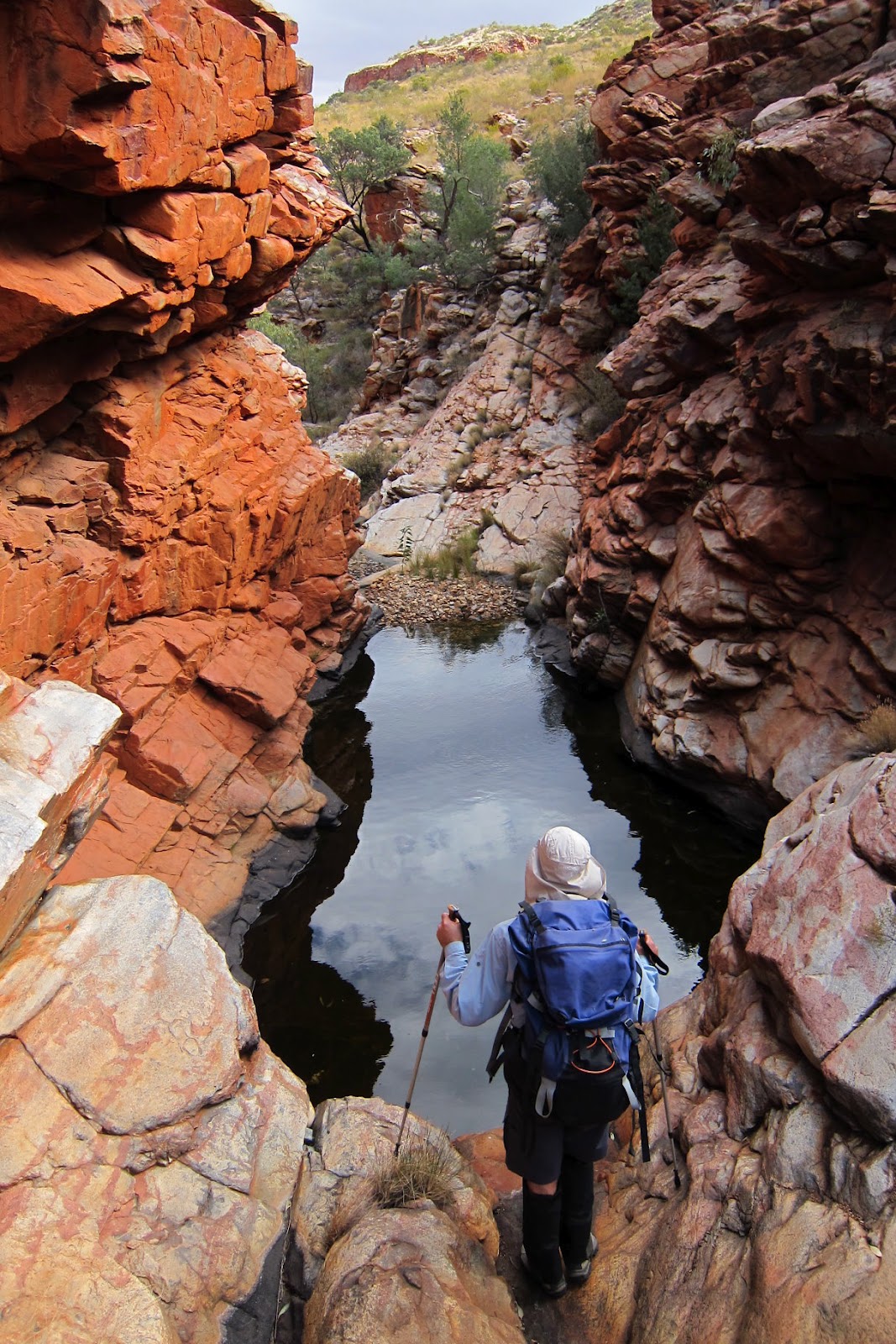
2, 3, 4.) It is hard to decide whether it is easier to walk along the ridge top or along a dry creek. Initially, we try the ridge, but soon find ourselves in a dry creek which turns into this interesting small gorge.


5.) The gorge doesn't last long and we are back walking on the dry creek.

6.) Can't follow the creek forever, so at some point, we get out of the creek and head towards Razorback which is the peak nearer to the centre of this pic. Again, the spinifex grass is everywhere.

7.) Getting closer to Mt Razorback ... the summit is the highest point in this photo.

At Mt Razorback summit
8.) Hurrah!!! 5 hours after we started walking, we reach the summit.

9.) At the summit with Ricky. In the background is Mt Zeil, highest mountain in NT (highest peak on the left hand side). We successfully climbed it 3 days ago.

10.) A nearby peak has this unusual red and green colour.

11.) Most satisfying view from the summit is looking north towards Mt Zeil (centre of the following pic) ... as we successfully climbed it 3 days ago.

12.) Not so happy is looking towards south-east at Mt Sonder, 4th highest mountain in NT (centre of the following pic). I didn't climb it due to blisters on both feet. Just means I'll have to be back here again to finished the job.

Fauna & Flora around Mt Razorback summit
13.) Black-coloured termite mounds like this one can be found only at the summit of Mt Razorback. I didn't notice any of them at lower slopes, nor at Mt Zeil. Very strange.

14.) Just like the termite mounds, these pretty pink flowers, Hakea grammatophylla, can be found only at the summit. I didn't notice any at lower slopes (nor at Mt Zeil).
It is considered rare due to its restricted distribution ... confined to the MacDonnell Ranges.

We have lunch at the summit, then it is time to return to the car.
Return to car via a 3-km long gorge
15.) Prior to the climb, on Google Earth, Ricky with his sharp eyes had noticed a possible gorge on a dry creek (different from the one we walked on this morning). So now on the return trip, we set the GPS and head for it. It turns out to be a most interesting 3-km narrow winding gorge.

16, 17.) Don't you just love walking inside a gorge like this !!!


18.) I am the spiderman !!!
Many places in the gorge require rock climbing ... climbing down cliffs which would have been waterfalls if there were water. I'm hopeless in rock climbing, hence it takes us a long time to get through the gorge.

19, 20.) The gorge keeps going on and on, a full 3km of it.


21, 22, 23, 24.) Careful !!! Don't want to slip into the water.


25.) Another beautiful waterhole.
26, 27, 28, 29, 30, 31.) The gorge keeps going on and on and on ...


32.) I am on my side to avoid the overhead rock.

33, 34, 35, 36.) More fantastic photos ... I can't keep my hands off the camera. The gorge may not be as spectacular as the ones you can see in movies or TV. You can point to other pictures that are more stunning than the ones here. But still, when is the last time you walked inside a gorge like this? ... and for 3 km?


37.) Not fishing. I'm trying to prevent myself from slipping into the water. The damp surface is slippery.

38.) A truly gorgeous place to walk through.

39.) Almost at the end of the gorge now ... down a cliff to get to where Ricky is, then round an amazing sharp 90 degree bend to the right, then ... see pic #40 ...

40.) After almost 2 hours of walking through the 3-km gorge, at the very end of it we encounter this final cliff. Due to smoothness of the rock face and the lack of any footholds, this small cliff is amazingly difficult to climb down. It takes me ages and requires Ricky to tell me where to put my hands and feet when climbing down.

Out of gorge - on our way to the car
Too much of a good thing can be too much.
Glad to be out of the gorge and out in the open.
Phew !!!
41.) I notice in many places, the rock face is red-brown,
but the inside is grey-white,
like this photo.
Weird.
Post script:
In the 2nd comment to this blog,
Ross Cayley gave a reason for the red-brown / grey-white colour.
Thank you Ross.

In summary
A most memorable day !
And yes, I got carried away in uploading so many photos of the gorge ... can't help it ... it was an amazing experience to walk through it !
The famous 223-km long Larapinta Trail was initially designed to extend westward to Mt Razorback. Instead, the trail now ends at Redbank Gorge because Mt Razorback was too remote. Just as well, for such a wonderful place, it is better to leave Razorback untouched as a truly wilderness area.
PS:
If you like walking inside a gorge, a suggestion is to visit the nearby Ormiston Gorge. Well worth spending half a day there.
Ricky and I were there 2 days ago.
Photos and trip report are in my blog:
http://mntviews.blogspot.com.au/2012/07/ormiston-gorge-nt-australia.html
nice read! Pre children in 1993, when fitter, we jumped off the melb-alice flight & hired a toy 4wd and drove out to Redbank, whizzing up Sonder for sunset that afternoon and returning without torches (d'oh). Next day we planned a quick but solid overnighter from Redbank to Zeil - didn't look more than 25-30k each way and we were used to hiking those distances in Vic. Unfortunately it was much slower going than it looked with fullpacks over all those little rocky spinifex gullies and we only made it to Razorback and spent the night camped on the summit. Just beautiful beyond compare. No people - even more fabulous. There's something about the vastness of the outback. The next day we hot footed back to Redbank, explored some more around Kings Canyon and finished up with Alice Spring's marathon. Love the Western Macs. Would love to do Giles next.
ReplyDelete12 years later, but noone has answered your question so: the red colour of arid area rocks is due to a phenomenon called 'desert varnish' which forms on rocks in arid regions where water evaporation routinely predominates over water runoff. Water that is slightly acidic, due to humic acids from vegetation etc, can dissolve small quantities of silica. When this water is allowed to evaporate from a rock surface, the silica precipitates out - over countless cycles, this silica builds up a 'smooth' mm-thick layer on the rock surface. Red dust/clay particles (ubiquitous across australia) trapped within this silica layer impart the red colour to the varnish. The pale rock colours that show underneath rock overhangs etc are places that don't often get wet, so don't grow 'silica varnish'. This is the true colour of the rock. Uluru is exactly the same - looks red, but the true rock colour is pale greyish - visible inside caves etc around the base. Places that are cooler and wetter, where water runoff predominates over evaporation, dont form 'desert varnishes'. The classic example in Australia is Tasmania. Thats why quartzite rocks in SW Tasmania are white - this is their true colour with no desert varnish.
ReplyDeleteHi Ross Cayley
DeleteThank you !!!