2015 March: One day climb to Gungartan & Kerries Ridge in NSW, Australia
Prolog - A2K peaks, the 33 highest peaks in Australia
I have compiled a list of all the peaks in Australia that are 2000 meters or higher. There are 33 of them, all bunched together in Kosciuszko National Park. I am calling the list Paul Ma's A2K peaks :-)
Rank Name Elev Grid Ref
1 Mt Kosciuszko 2228 m 132 647
2 Mt Townsend 2209 m 128 684
3 Mt Twynam 2196 m 179 716
4 Rams Head 2190 m 128 608
5 Etheridge Ridge 2180 m 140 644
6 Rams Head North 2177 m 137 618
7 Alice Rawson Peak 2167 m 132 692
8 Byatts Camp 2159 m 118 676
9 Abbott Peak 2145 m 122 678
10 Carruthers Peak 2145 m 157 698
11 Tenison Woods Knoll 2136 m 166 719
12 Mt Northcote 2131 m 146 676
13 Little Twynam 2130 m 185 711
14 Muellers Peak 2125 m 138 673
15 Mt Clarke 2110 m 154 672
16 Mt Lee 2105 m 152 688
17 Kangaroo Ridge 2077 m 182 644
18 Mt Tate 2068 m 214 760
19 Gungartan 2068 m 258 835
20 Mt Jagungal 2062 m 248 987
21 Mt Perisher 2054 m 243 697
22 Mt Stilwell 2054 m 187 659
23 South Rams Head 2052 m 116 588
24 Kerries Ridge 2050 m 262 851
25 Little Stilwell 2030 m 190 657
26 Merritts Spur 2030 m 160 626
27 Toolong Range 2025 m 258 988
28 Watsons Crags 2021 m 161 733
29 Back Perisher Mtn 2014 m 247 708
30 Mt Anton 2010 m 191 727
31 The Foxhole 2010 m 198 661
32 Mann Bluff 2005 m 208 754
33 Dicky Cooper Bogong 2003 m 232 832
How the list is compiled:
- If a peak has a name, and is 2000 meters or higher, then include the peak in the list.
- If a range/ridge/spur has a name, and its highest point is 2000 meters plus, then include the highest point.
For more information on the list, including data source, please click on this link:
http://mntviews.blogspot.com.au/p/paul-mas-a2k-peaks.html
Today's climb: Gungartan & Kerries Ridge
Continuing my effort to climb all these A2K peaks ... Today's climb with Adam, Daniel & Saf is to:
Rank Name Elev Grid Ref
19 Gungartan 2068 m 258 835
24 Kerries Ridge 2050 m 262 851
Other A2K climbing trips
Scroll forward to the end of this trip report. There is a list, with links, to other A2K climbing trips that I have done.
Maps for Gungartan & Kerries Ridge
1:100,000 8525 Kosciuszko
1:50,000 Kosciuszko Alpine Area map, 1st edition, by Spatial Vision Innovations Pty Ltd
1:25,000 8525-2N Geehi Dam
The relevant part of the 1:25,000 scaled map can be downloaded from:
https://drive.google.com/file/d/0B877-h5SCJaSSTZndlVVem9aQ1U/view?usp=sharing
GPS tracklog file & Route
Our GPX tracklog file can be downloaded from:
https://drive.google.com/file/d/0B877-h5SCJaSSVhEbWZBdGRfUEk/view?usp=sharing
The 1:25,000 scaled map with our tracklog superimposed on it can be downloaded from:
https://drive.google.com/file/d/0B877-h5SCJaSYWZIOEIzbjV2bDg/view?usp=sharing
For what it is worth, I have put the map here. But you are better off to download the map from the above link.
- Our tracklog is in brown colour.
- The upper red arrow points to Schlink Hilton Hut.
- The middle red arrow points to Whites River Hut.
- The lower red arrow points to Horse Camp Hut.


In summary, our route is:
- Park car at Guthega Power Station.
- Walk on Schlink Pass Road to Horse Camp Hut.
- To Whites River Hut.
- To Schlink Hilton Hut.
- Go off track eastward to Kerries Ridge north peak.
- To Kerries Ridge main summit.
- To Kerries Ridge south peak.
- To Gungartan summit.
- To Gungartan twin peak.
- Go westward to Schlink Pass Road.
- Take Disappointment Spur Trail to Disappoint Spur Hut.
- Continue on Disappointment Spur Tail back to the car at Guthega Power Station.
Timeline & Distance
08:15 0.0 km Start at Guthega Power Station
09:41 4.3 km at Horse Camp Hut
09:45 4.4 km leave Horse Camp Hut
10:44 7.8 km at junction of Schlink Pass Road & Disappointment Spur Trail
11:15 9.3 km at Whites River Hut
Morning Tea
11:44 9.7 km leave Whites River Hut
12:33 12.8 km at Schlink Hilton Hut
12:43 12.9 km leave Schlink Hilton Hut
13:50 15.0 km at Kerries Ridge north peak
14:00 15.0 km leave Kerries Ridge north peak
14:07 15.3 km at Kerries Ridge main summit
14:15 15.3 km leave Kerries Ridge main summit
14:20 15.4 km at Kerries Ridge south peak
14:23 15.4 km leave Kerries Ridge south peak
14:55 17.0 km at Gungartan summit
Lunch
15:23 17.1 km leave Gungartan summit
15:28 17.2 km at Gungartan twin peak
15:39 17.2 km leave Gungartan twin peak
16:31 18.8 km at Schlink Pass Road
17:13 21.8 km at junction of Schlink Pass Road & Disappointment Spur Trail
17:54 24.6 km at Disappoiment Spur Hut
17:58 24.7 km leave Disappointment Spur Hut
19:01 28.7 km Finish at Guthega Power Station
===================================
Total: 9 hr 46 min;
28.7 km - Distance is from Google Earth.
31.6 km - Distance is from Garmin GPS.
Pictures
1) Guthega Power Station ~~~
We park our car at where I'm standing in the pic - the near side of the bridge.
The start of the Schlink Pass Road where we'll be walking, is across the bridge and behind the building on the right side of the pic.

2) Walking up Schlink Pass Road and looking back at Guthega Power Station

3) Schlink Pass Road ~~~
Don't even think about it ... Ordinary folks like us are not allowed to drive on it. It is blocked at the Guthega Power Station :-(
The mountain at the centre of the pic is Gungartan. We can't see its summit yet.

4) A detour to check out Horse Camp Hut - an emergency shelter.

5) Around this time, I look up at the sky and couldn't believe my eyes ... WOW !!! ... an iridescent cloud ... Love this !!!
It is an uncommon phenomenon, the result of diffraction ... small droplets of water or small crystals of ice individually scattering light.
If the small droplets/crystals are of similar size, their cumulative effect is seen as iridescent colours. The cloud must be optically thin, so that most rays encounter only a single droplet. Iridescence is therefore mostly seen at cloud edges or in semi-transparent clouds.

6) Munyang River ~~~
The mountain on the right side of the pic is Gungartan. We can't see its summit yet.

7) Looking back down the valley where Munyang River flows towards Guthega Power Station ~~~
Is the red arrow pointing to Mt Blue Cow ?

8) On Schlink Pass Road, passing a boulder field

9) An eerie scene of dead trees and the moon ~~~
The trees are dead due to a devastating bushfire in 2003.

10) Nice scenery ... but all the trees are dead from a 2003 bushfire, hence the grey colour on the entire slope of the mountain.

11) There are plenty of Acripeza reticulata (Mountain Katydid, also known as Mountain Grasshopper). The one on left and also the one on top right of the pic is a female. When its wings are folded, it looks like a small lump of dirt and is not easy to be spotted. But when its wings are spread out, you can see the beautiful red, blue & black bands on its body.
The male is much skinnier - bottom right.

To be able to snap this beautiful insect and also the iridescent cloud (photo #5) is one of the many reasons why hiking is such a wonderful pursuit. You never know what incredible images nature will reveal to you.
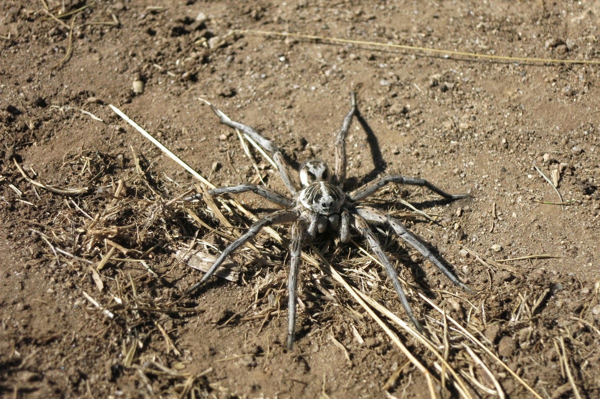
12) Saf finds this big Wolf Spider which scares the shit out of him :-)
13) A detour to check out another emergency shelter ~~~
This one is Whites River Hut.

14) Finally, after 4 hrs on the Schlink Pass Road, we can see Gungartan summit - the red arrow on the left.
The arrow on the right points to its twin peak, one or two meters lower than the main summit.

We are not climbing Gungartan yet. We'll walk north for another kilometer to check out Schlink Hilton Hut; then go off track eastward to climb Kerries Ridge before tackling Gungartan.
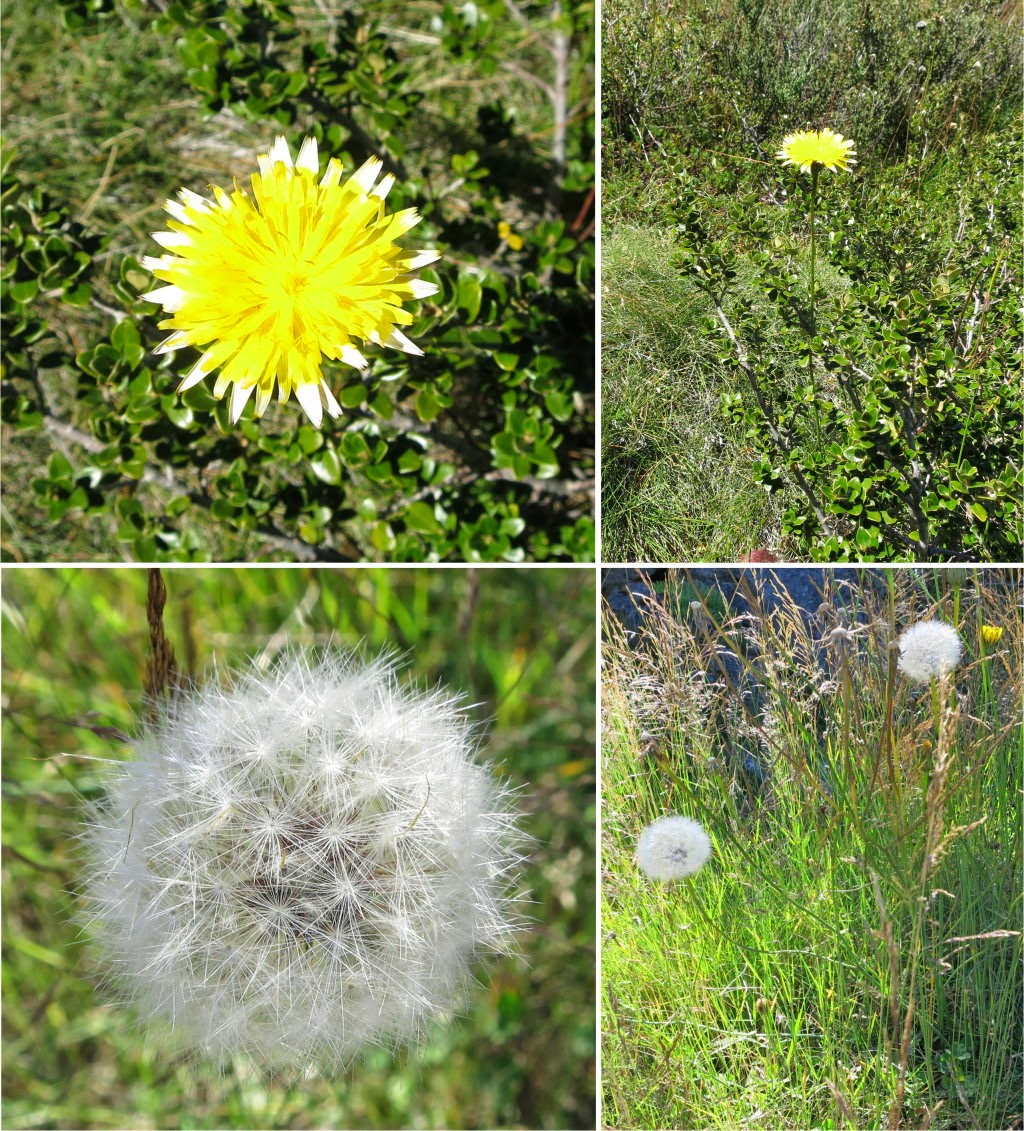
15) Beautiful setting of yellow alpine flowers and white (dead) tree trunks. Hey Daniel, you are spoiling the scene !
Does anyone know how to photoshop him out the the picture and perhaps insert a beautiful girl instead?

16) ... Nevermind, I get rid of Daniel now :-)

17) Some of the flowers in the previous photo is Xerochrysum bracteatum (??? not sure) commonly known as Golden Everlasting or Strawflower.
.jpg)
18) I think this is Microseris lanceolata (Murnong or Yam Daisy) - correct me if I'm wrong. The flower ripens to a ball of fluffy seeds to be dispsersed by the wind.
.jpg)
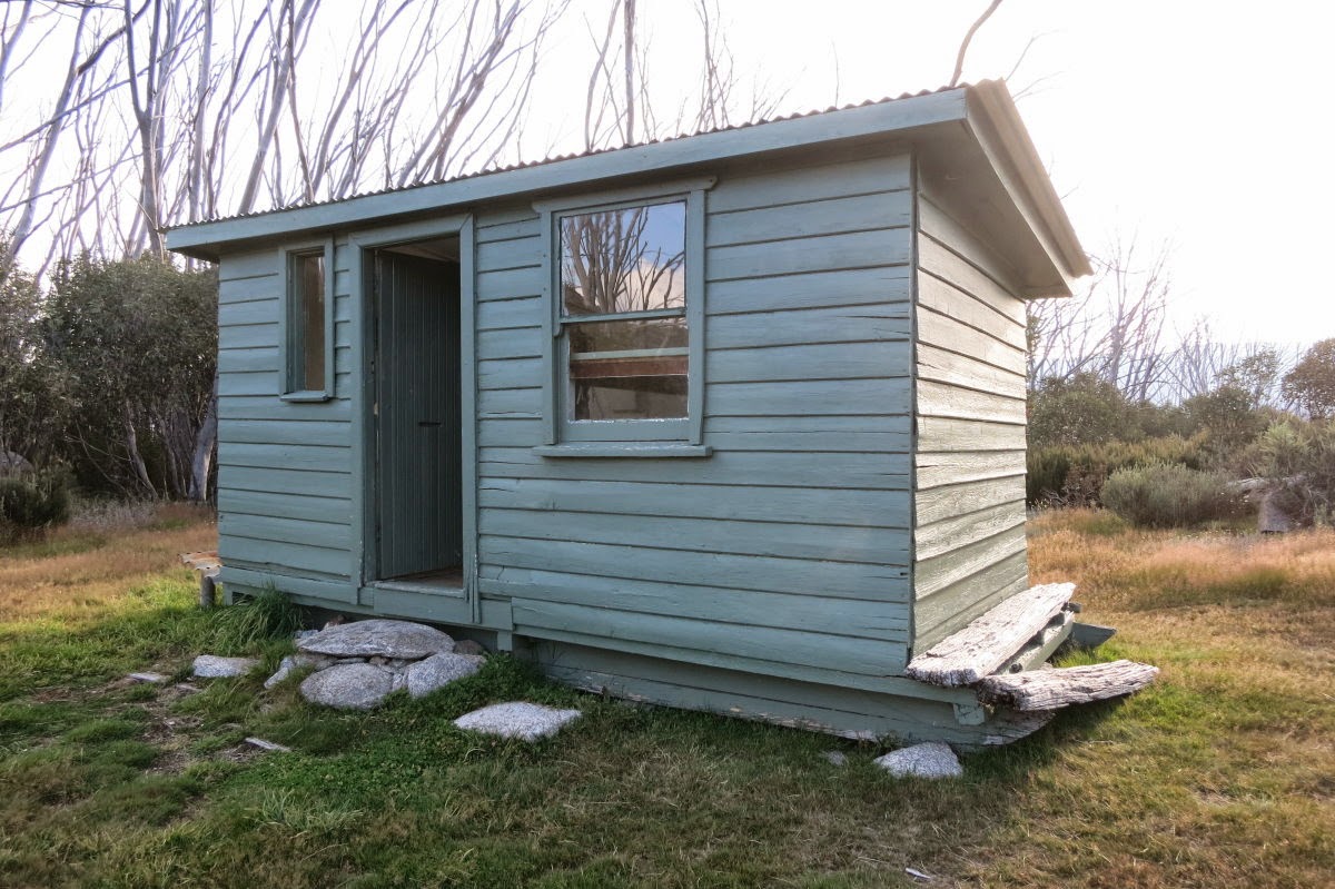
19) A visit to Schlink Hilton Hut ~~~ No wonder it is called Hilton ... for a start, it is large by the standard of emergency shelters. And secondly, all beds have mattresses ... plus cushioned chairs ... what a treat !

20) From Schlink Hilton Hut, we go off track eastward to climb Kerries Ridge.

21) Looking back at Schlink Hilton Hut ~~~
- The highest peak above the hut is Dicky Cooper Bogong, 2003 meters.
- To the left of Dicky Cooper Bogong is an unnamed peak of 1976 meters.
- Further to the left are the twin peaks of The Granite Peaks.
- The entire mountain range to the left of Dicky Cooper Bogong is called The Rolling Ground.

7 months later, in 2015-10, I climbed Dicky Cooper Bogong and the north peak of The Granite Peaks. Photos and a write up of that climb is in my blog:
http://mntviews.blogspot.com.au/2015/10/dicky-cooper-bogong-granite-peaks-nsw.html
22) Kerries Ridge is in sight. We'll walk along the ridge top:
- Start from the left, the north peak;
- to the main summit 2040 m at the centre;
- then to the south peak on the right.
It doesn't look like it from the photo, but the main summit at the centre is the highest point of Kerries Ridge ... see next photo.

23) (Click on the pic to enlarge it.)
We are now closer to Kerries Ridge. From left to right, the red arrows point to:
- north peak of Kerries Ridge (we are heading there first)
- main summit 2040 m at the centre
- south peak
- Gungartan
To the right of Gungartan, very faint on the horizon, is Main Range and Abbott Range.

24) Multi-coloured carpet on the slope of Kerries Ridge. The peak on the top-left corner is the north peak. We are heading there now.

25) The highest pile of rocks in the pic is the north peak of Kerries Ridge.

26) Daniel at the top of the north peak

27) We are now at top of north peak, and looking towards the south:
- The peak at the centre of the photo is the main summit of Kerries Ridge - we'll be heading there next.
- The red arrow points to Gungartan.
- The horizontal bar is Main Range and Abbott Range.

28) We've climbed down from the north peak and is close to the main summit which is the pile of large boulders at the centre of the pic.

29) At Kerries Ridge main summit, 2040 m ~~~
Clockwise: Paul, Daniel, Saf, Adam

30) Needless to say, there is a 360 panoramic view from the main summit. Here, to the north is Mt Jagungal, 2061 m (red arrow), one of the A2K peaks yet to be climbed ... watch this blog :-)

31) To the south is:
- Gungartan (left arrow), we'll be heading there.
- Main Range and Abbott Range (horizontal bar)
- Dicky Cooper Bogong (right arrow)

32) We are climbing down the south face of the main summit.
%2C%2BKosciuszko%2BNat%2BPk.jpg)
33) Heading towards the south peak of Kerries Ridge (red arrow)

34) Now at the top of the south peak, looking back at the main summit.

Ok, that is Kerries Ridge completed and ticked off the A2K list :-) ... now heading to Gungartan.
35) We've come down from Kerries Ridge and looking back at it ~~~
The 3 arrows point to, from left to right:
- north peak
- main summit
- south peak (we just came from there.)
In the foreground are some rocks forming a cute hole which can be handy as a shelter.

36) Heading towards Gungartan (red arrow) ~~~ The bottom photo is taken closer to the mountain.

37) Looking back at where we came from ... the arrows point to, from left to right:
- Mt Jagungal
- north peak of Kerries Ridge
- main summit
- south peak (we just came from there.)

38) Gungartan summit is just in front - where the trig is.

39) Gungartan summit

40) At Gungartan summit, 2068 m ~~~
Clockwise: Paul, Daniel, Saf, Adam

41) At the Gungartan summit, there is also a splendid 360 degree panoramic view.
Towards the north, the red arrows point to:
- Mt Jagungal
(The next 3 are peaks on Kerries Ridge which we have just climbed.)
- north peak
- main summit, 2040 m
- south peak

42) Towards the south is Gungartan's nearby twin peak, only a meter or two lower. We'll climb it next.
The red horizontal bar is the Main Range and Abbott Range ... see next photo.

43) Zooming onto Main Range & Abbott Range (both are in Kosciuszko National Park) ~~~
The 4 red arrows point to peaks in the Main Range. From left to right:
- Little Twynam
- Etheridge Ridge
- Mt Twynam
- Unnamed 2136 meter peak to the west of Mt Twynam, half way between Mt Twynam and Mt Sentinel
The 4 blue arrows point to peaks in the Abbott Range. From left to right:
- Byatts Camp
- Abbott Peak
- Mt Townsend
- Alice Rawson Peak
Glad to see these old friends as I have climbed them all.
We can't see Mt Kosciuszko as it is behind Mt Twynam.

44) We've come down from Gungartan summit and is now climbing up its nearby twin peak.

45) At Gungartan's nearby twin peak now, and looking back towards the north at the main summit with a trig on top.
The red arrow points to Mt Jagungal.

46) After all the climbing, Saf is still energetic. He climbs up to the top of a nearby rocky outcrop.

47) In this photo, we've just climbed down from Gungartan and are heading directly westward towards Schlink Pass Road.
The red arrow points to the main summit. Immediately to its right is its twin peak.

48) On the slope of Gungartan, alpine flowers are abound ... don't you just love them !

49) I've been searching this flower for quite a while. Finally, today, I find it !
It is Chionogentias muelleriana susp alpestris (Mountain Gentian); exists only in Kosciuszko National Park. The delicate cup-shaped flower displays distinctive purple lines inside the petals.

50) Looking back at Gungartan ~~~
- The left arrow points to its main summit.
- The right arrow points to its twin peak.

51) Schlink Pass Road is in front. The mountain we are facing is Dicky Cooper Bogong.

52) We are now on Schlink Pass Road, and looking back with satisfaction at Gungartan.
- The arrow on the left points to its main summit.
- The arrow on the right points to its twin peak.

The above Photo #52 and an earlier photo #14 are taken at the same spot. The colours are different because the earlier photo was taken in the morning, with the camera facing towards the sun. The later photo was taken in the afternoon with the sun away from the camera lens.
53) Walking back to our car at Guthega Power Station ~~~
This morning, we came from Schlink Pass Road on the right. Now, we take the Disappoinment Spur Trail on the left. As the name suggests, it goes along the Disappoinment Spur ... but why would anyone want to name a spur as Disappoinment Spur?

54) Along the trail, whenever there is a creek flowing towards the trail, there is one of these contraption. Not sure what they are. Seems to be a channel to capture the water and perhaps to feed the water to an underground pipe to Guthega Power Station ???

55) Passing Disappointment Spur Hut ~~~
This one is small, a bit of a disappointment compared to the other 3 huts we visited today.
56) On Disappointment Spur Trail, looking down the valley where the Munyang River flows towards Guthega Power Station ~~~
The large mountain in the background is Blue Cow Mountain.

In Summary
It is a wonderful day! In addition to climbing Kerries Ridge and Gungartan, we visited:
- Horse Camp Hut
- Whites River Hut
- Schlink Hilton Hut
- Disappointment Spur Hut
4 huts in a day must be a record :-) Has anyone visited more than 4 huts in a day?
And snapped wonderful pictures of an iridescent cloud (Photo #5) and the colourful body of a Mountain Katydid (Photo #11).
Thanks for the company of Adam, Daniel and Saf.
Other A2K climbing trips
• 2017 November
Rank Name Elev Grid Ref
20 Mt Jagungal 2062 m 248 987
27 Toolong Range 2025 m 258 988
Trip report will be written up soon ... whatever that means :-)
In the mean time, if you like to know the details, contact me.
• 2017 January with AB
Rank Name Elev Grid Ref
18 Mt Tate 2068 m 214 760
32 Mann Bluff 2005 m 208 754
Photos and trip report are in my blog:
http://mntviews.blogspot.com.au/2017/01/mt-tate-mann-bluff-gills-knobs.html
• 2016 December with AB
Rank Name Elev Grid Ref
3 Mt Twynam 2196 m 179 716
11 Tenison Woods Knoll 2136 m 166 719
28 Watsons Crags 2021 m 161 733
30 Mt Anton 2010 m 191 727
Photos and trip report are in my blog:
http://mntviews.blogspot.com.au/2016/12/tenison-woods-knoll-watsons-crags.html
• 2016 December with AB & DN
Rank Name Elev Grid Ref Comment
17 Kangaroo Ridge 2077 m 182 644 Morning
21 Mt Perisher 2054 m 243 697 Afternoon
22 Mt Stilwell 2054 m 187 659 Morning
25 Little Stilwell 2030 m 190 657 Morning
28 Back Perisher Mtn 2014 m 247 708 Afternoon
31 The Foxhole 2010 m 198 661 Morning
Photos and trip reports are in my blog:
- Morning: http://mntviews.blogspot.com.au/2016/12/mt-stilwell-and-kangaroo-ridge.html
- Afternoon: http://mntviews.blogspot.com.au/2016/12/mt-perisher-back-perisher-mtn.html
• 2015 October with RZ
Rank Name Elev Grid Ref
33 Dicky Cooper Bogong 2003 m 232 832
Photos and trip report are in my blog:
http://mntviews.blogspot.com.au/2015/10/dicky-cooper-bogong-granite-peaks-nsw.html
• 2015 March with AB, DN & Saf
Rank Name Elev Grid Ref
19 Gungartan 2068 m 258 835
24 Kerries Ridge 2050 m 262 851
Today's trip :-)
• 2014 December with AB & DN
Rank Name Elev Grid Ref Comment
1 Mt Kosciuszko 2228 m 132 647
2 Mt Townsend 2209 m 128 684 Abbott Range
7 Alice Rawson Peak 2167 m 132 692 Abbott Range
8 Byatts Camp 2159 m 118 676 Abbott Range
9 Abbott Peak 2145 m 122 678 Abbott Range
10 Carruthers Peak 2145 m 157 698
12 Mt Northcote 2131 m 146 676
wrong Byatts Camp 2110 m 116 671 Abbott Range
15 Mt Clarke 2110 m 154 672
16 Mt Lee 2105 m 152 688
Photos and trip report are in my blog:
http://mntviews.blogspot.com.au/2014/12/lee-northcote-clarke-abbott-range.html
• 2014 November with AB & DN
Rank Name Elev Grid Ref
1 Mt Kosciuszko 2228 m 132 647
4 Rams Head 2193 m 128 608
5 Etheridge Ridge 2180 m 140 644
6 Rams Head North 2177 m 137 618
23 South Rams Head 2052 m 116 588
Photos and trip report are in my blog:
http://mntviews.blogspot.com.au/2014/11/etheridge-ridge-kosciuszko-rams-head.html
• 2014 April with DH
Rank Name Elev Grid Ref
1 Mt Kosciuszko 2228 m 132 647
2 Mt Townsend 2209 m 128 684
3 Mt Twynam 2196 m 179 716
10 Carruthers Peak 2145 m 157 698
13 Little Twynam 2130 m 185 711
and incidentally bagging the 3 highest peaks of Australia in one day. Photos and trip report are in my blog:
http://mntviews.blogspot.com.au/2014/04/kosciuszko-townsend-twynam-carruthers.html
• 2011 April with RE
Rank Name Elev Grid Ref
1 Mt Kosciuszko 2228 m 132 647
2 Mt Townsend 2209 m 128 684
14 Muellers Peak 2125 m 138 673
Photos and trip report are in my blog:
http://mntviews.blogspot.com.au/2011/04/kosciuszo-muellers-peak-townsend-nsw.html
No comments:
Post a Comment