2015 July: Day trip to climb Mt Sonder, West Macdonnell National Park, NT, Australia
Prolog - Mt Sonder
It annoys me a lot that I didn't climb Mt Sonder three years ago, when I was here in the West Macdonnell National Park. (My feet developed a bad blister after climbing Mt Zeil and walking around Ormiston Pound.) It is time to make amends.
Mount Sonder, or Rwetyepme ("The Pregnant Lady", its Aboriginal name), is the 4th highest mountain in NT (the Northern Territory) at 1380 meters.
It lies on the western part of the Macdonnell Ranges and marks the end (section 12, the final section) of the Larapinta Trail which is a 223-km track starting from Alice Springs.
There is a walking track that approaches the mountain from the west - from Redbank Gorge carpark. The track ends at the south-west summit at around 1352 meters. I call it the false summit. The true summit, at 1380 meters lies at another 800 meters (as the crow flies) to the north-east.
To the true summit
On the way to the true summit, the climb down from the false summit involves scrambling down rocks and loose stones. Not only does it look steep and difficult, but scary too. Hence for safety reasons, the NT National Parks authorities have chosen the false summit as the destination peak of Mt Sonder. They have erected a cairn there and placed a plaque on top of it to say that the summit of Mt Sonder is there ... see photo #16.
Most climbers will stop at the false summit and go no further.
However, I don't find it difficult to climb down the false summit. There are plenty of other climbs that I have done which were more daunting. One of my Mt Zeil climbing companion, Jeremy, had climbed the true summit four years earlier. Armed with his GPS tracklog, and knowing that I am tracing the exact same steps as his, I find it quite easy going.
The same cannot be said of David, my climbing companion of this trip. He follows me down the slope for a little while, decides he has enough of the steepness, and climbs back up the slope and returns to the car early.
I continue on to the true summit and not long afterwards am pleasantly surprised to be joined by the friendly Prathiba. Not many woman would be willing to climb up there alone ... good on her! Well, she solves my problem of how to take a selfie with the summit trig from a distance :-)
Map
Below is 1:250,000 scaled Hermannsburg SF53-13 map
- The blue arrow on the left points to Redbank Gorge day parking area.
- To the right of Redbank Gorge is a black dash line representing a foot track towards Mt Sonder. It ends at the false summit, pointed to by the blue arrow on the right.
- This track to the false summit is section 12, the final section, of the well known Larapinta Trail.
- The true summit is at the triangle marker, another 800 meters (as the crow flies) to the north-east.
- On the map, Section 11 of the Larapiinta Trail is the black dash line parallel and below the Mt Sonder foot track.
- Namatjira Drive is a sealed road from the east all the way to the turn off to Redbank Gorge. The access road to Redbank Gorge is not sealed, but is ok for a 2-wheel drive car.

Mt Razorback: http://mntviews.blogspot.com.au/2012/07/razorback-nt-australia.html
Mt Zeil: http://mntviews.blogspot.com.au/2012/07/zeil-nt-australia.html
GPS tracklog files & Route
Our GPX tracklog files can be downloaded from:
• From carpark to false summit, then to true summit:
https://drive.google.com/file/d/0B877-h5SCJaSTlNKV25FWTdoYmc/view?usp=sharing
• Return from true summit to carpark:
https://drive.google.com/file/d/0B877-h5SCJaScm5nWVNwZ2ZmZmM/view?usp=sharing
Here is the Google Earth tilted view of Mt Sonder (North is towards the top right hand corner) ~~~
- Our tracklog is in turquoise colour
- Start from Redbank Gorge day parking area at the left tip of the tracklog.
- The 2 red arrows at the lower half of the pic are, from left to right, the false and true summits.
- The 2 red arrows at the upper half of the pic are, from left to right, Mt Razorback and Mt Zeil.
- The green lines are the boundaries of the West Macdonnell National Park.

In summary:
- Start from Redbank Gorge day parking area.
- To a nearby lookout.
- Descend to Redbank Creek and cross it.
- To false summit.
- Retrace steps for 170 meters, then turn right (north) to go off track to true summit.
- Then return to carpark.
Timeline & Distance
07:40 0.0 km Start walking from Redbank Gorge day parking area
07:43 0.1 km At lookout near carpark
07:45 0.1 km Leave lookout
07:53 0.5 km Cross Redbank Creek
10:15 7.2 km Stop for morning tea
Morning tea
10:21 7.2 km Resume walking
10:28 7.6 km At where we'll exit walking track and head for true summit later on
10:31 7.7 km At Mt Sonder false summit
10:50 7.8 km Leave false summit
10:53 7.9 km Exit walking track
11:45 8.9 km At true summit
Lunch
12:38 9.0 km Leave true summit
13:32 10.1 km Meet up with walking track
14:14 12.2 km Stop for afternoon tea
Afternoon tea
14:19 12.3 km Resume walking
15:40 17.2 km Cross Redbank Creek
15:43 17.4 km Back at the car
==============================================
Total: 8 hrs 03 mins at leisurely pace
17.4 km Distance is from Google Earth
18.9 km Distance is from Garmin GPS
Pictures - To Mt Sonder false summit
1) Redbank Gorge day parking area ~~~
- The red Hyundai is our hired car.
- No! The hill you can see in this pic is not Mt Sonder ! It is not that simple :-)

2) First, we detour to a lookout where we can see Redbank Creek (the dry creek) and Redbank Gorge (red arrow). The creek is almost permanently dry ... because we are in a desert in the middle of Australia.

3) From the lookout, we climb down to the dry Redbank Creek. Hikers attempting the Larapinta Trail camp at this spot. A rain water tank has been installed for their benefit.

4) Crossing Redbank Creek

5) We are on the walking track to Mt Sonder now. The red cliffs are basking in the early morning sun.

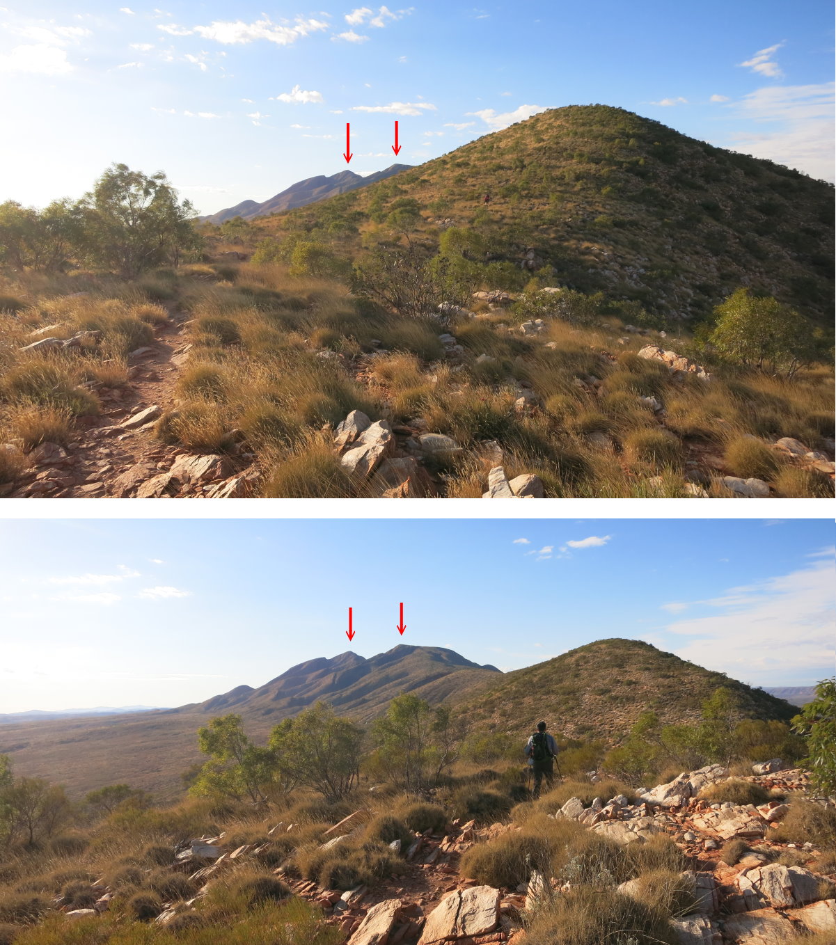
6) An hour into our walk (upper photo), we can see Mt Sonder. The lower photo is taken another 15 minutes later
- The red arrows point, from left to right, to the true and false summits respectively.
7) David, my hiking companion for this NT trip is on the left edge.
- The red arrows point to Mt Razorback and Mt Zeil respectively.

I climbed Mt Razorback with Ricky 3 years ago. Around the same time, climbed Mt Zeil with Ricky & Jeremy.
Photos and write ups on the Mt Razorback and Mt Zeil climbs are in my blog:
Mt Razorback: http://mntviews.blogspot.com.au/2012/07/razorback-nt-australia.html
Mt Zeil: http://mntviews.blogspot.com.au/2012/07/zeil-nt-australia.html
8) Someone had erected these stones on the track ... cute :-)

9) This pic is taken at the same spot as the previous pic.
- The red arrows point to the true and false summits respectively.

10) Clint Garrett wrote in the Comment Section that this flower is Hakea grammatophylla.
Mt Sonder has exactly the same flora as Mt Razorback. And so this flower is abundant near the summit of Mt Razorback as well. But the plant is considered rare due to its restricted distribution ... confined to the MacDonnell Ranges. However it is strange I didn't notice them on Mt Zeil, even though it is just nearby.

11) Clint Garrett wrote in the Comment Section this is Eucalyptus sessilis, commonly known as Finke River mallee or River mallee. Thanks Clint.

12) Plenty of these black termite mounds along the track ~~~
They seem to be distinct in this part of the world. I have only seen them at Mt Razorback, but not on the nearby Mt Zeil.

13) Close to Mt Sonder now ~~~
The peak is this pic is the false summit. The true summit is behind it and can't be seen here.

14) The false summit is just in front.

At Mt Sonder false summit
15) David and I at the false summit. ~~~
By the way, David is actually taller than me, it is just that I'm standing on top of a rock :-)

This is a very popular mountain. Considering it is in the middle of a desert in the center of Australia, I am amazed at the number of people here today. In fact, earlier on, there were at least 20 plus hikers climbing up here in the dark to watch the sun rise ... nah, not for me, I'm not an early riser, nor a sun worshipper :-)
16) There is a metal plaque on top of the cairn of the previous photo. The words in the centre circle read "Mt Sonder (Rwetyepme) at 1380 metres above sea level is the 4th highest mountain in the Northern Territory."
- But this is a truly untrue statement!!! This is not the real summit of Mt Sonder, nor is it at 1380 meters. It is 28 meters lower at only 1352 meters.
- Just to throw a spanner in the works, at about 150 meters north-west of where this cairn is, Google Earth says it is 12 meters higher at 1364 meters. So even the cairn is erected at the wrong place !!!
- The true summit is in the next pic ...

17) Standing at the false summit, we can clearly see the true summit of Mt Sonder ... it is beckoning to us to climb it. How to get there is not so obvious. Sharp drops and the line of vertical cliff barring a direct approach. But thanks to Jeremy who climbed the true summit 4 years earlier in 2011, and who had sent me his GPS tracklog file, I simply turn on my GPS and follow his footsteps without having to do much surveying. Ah, GPS, it makes life too easy!
- (Click on the pic to enlarge it.) In the pic, the turquoise arrow is where I will leave the walking track (by turning right - ie turning north); then walk in the direction of the arrow to roughly where the line ends; then climb down the steep slope behind the line of cliff.
- The red arrows points to Mt Razorback and Mt Zeil respectively.

18) Still at the false summit, towards east & south-east ~~~
- Macdonnell Ranges is the mountain chain that runs across the centre of the pic.
- Glen Helen Gorge is the gap at the dead centre of the pic. It breaks the Macdonnell Ranges in two! Last night, we stayed at Glen Helen Homestead Lodge which is located at the Gorge.

To Mt Sonder true summit
19) This Google Earth tilted view shows how I (and Jeremy 4 years ago) climb Mt Sonder's true summit. (Click on the pic to enlarge it.)
- The left red arrow points the true summit. The right red arrow points to the false summit.
- Exit the walking track by turning north at where the black arrow points to. (Top right hand corner has a compass bearing.)
- My tracklog is in turquoise colour. The to-summit route is lower on the slope. The return route is higher on the slope.
- The yellow lines indicate a line of cliffs which prevent us from crossing them.

20) Another Google Earth tilted view ... this one is from the view point of where we exit the walking track. (Click on the pic to enlarge it.)
- The upper red arrow points the true summit. The lower red arrow points to the false summit.
- Exit the walking track by turning north at where the black arrow points to. (Top right hand corner has a compass bearing.)
- My tracklog is in turquoise colour. The to-summit route is lower on the slope. The return route is higher on the slope.
- The yellow lines indicate a line of cliffs which prevent us from crossing them.

21) This is where we leave the walking track and head towards the true summit. In a few more meters, we'll be climbing down a steep slope.

22) We are down on the steep slope and looking towards the true summit. As you can see from the pic, In a few more meters, the slope will dip down to become even steeper ! ... but it isn't dangerous ... actually quite fun. Let's put it this way, Jeremy and many others have done it and survived :-)

23) I'm halfway down down the almost vertical slope. But it is not for David. At this point, he has had enough of the rock scrambling and decides to climb back up to the ridge and return to the car. So now I'm all alone by myself ... or so, I thought ... read on to Photo #33 ...

24) At where I was standing in the previous pic, looking at Jeremy's tracklog file on how to climb the true summit ~~~
- The turquoise arrows show the climbing route.
- The purple arrow indicates the return route that I'll take. (Click on the pic to enlarge it.)

25) I am now standing near the middle arrow of the 5 turquoise arrows on the right side of the previous pic.

26) Proceeding further towards the true summit and looking back at where I came from (Click on the pic to enlarge it.) ~~~
- Red arrows point to, from left to right: Mt Sonder false summit, Mt Razorback, Mt Zeil.
- Turquoise arrows: How I get to where I am now.
- Purple arrows: The return route. (More on the return route is in Photo #29.)

27) The true summit is within grasp. ~~~
Just in front of me is a fissure in the cliff ... I'll get around it from the bottom left corner of this pic.

28) The fissure of the previously mentioned pic ~~~
- The Macdonnell Ranges is across the top of the photo.
- To its left is Ormiston Pound and Mt Giles.

I have not climbed Mt Giles (which is the 3rd highest mountain in Northern Territory), but have done the circuit walk around the Ormiston Pound with Ricky.
Photos and write up on the Ormiston trip are in my blog:
http://mntviews.blogspot.com.au/2012/07/ormiston-gorge-nt-australia.html
29) Looking back at Mt Sonder's false summit pointed to by the red arrow. The purple arrows show the route I'll take to climb back up the slope. (Click on the pic to enlarge it.)

30) Plenty of these black termite mounds on the slope.

31) The true summit is in front.

At Mt Sonder true summit
32) Hurray! I reach the true summit! 1380 meters, easy! 50 minutes at leisurely pace after exiting the walking track ... taking the time to enjoy the scenery, no need to rush :-)

33) Just when I was pondering on how to take a selfie of myself with the summit trig from a distance, out pops a friendly Prathiba who is from Darwin and is on a climbing holiday here. She met David after he climbed back up to the top of the ridge. David told her to follow me to climb the true summit; and unbeknownst to me, she has since been hot on my tail for the past 50 minutes ... or something like that :-)

34) Prathiba solves my problem of how to take a selfie from a distance. She takes the photo instead. (The backpack and trekking poles in front of me belong to her.)

There is supposed to be a log book at the base of the cairn. I didn't look for it. Prathiba is here, and you know, how man gets distracted by a friendly woman ... :-) I am too busy ...
35) ... too busy in taking a selfie of us :-)

36) And take in the splendid view from the summit
- The red arrows point to, from left to right: Mt Sonder false summit, Mt Razorback, Mt Zeil.

37) Still at the true summit ~~~
The Macdonnell Ranges is across the the entire centre of this pic.
- On the far left side of the pic is Ormiston Pound and Mt Giles.
- Glen Helen Gorge is at the dead centre of the pic - the gap that breaks the Macdonnell Ranges in two. Last night, we stayed in Glen Helen Homestead Lodge which is located at the Glen Helen Gorge.

Leave true summit
38) Time to leave the summit - which is above the top right hand corner of this pic ~~~
Initially, I'm leading and looking back at Prathiba ...

39) ... but Prathiba is fast, so I let her lead instead :-)
In this pic, you can see a fissure across the middle of the pic, slanting from left edge towards the bottom right corner. We'll get a good view down the fissure ... see next photo ...

40) Looking down the fissure mentioned in the previous pic ~~~
This is not the same fissure as in Photo #28, but the view is the same.

41) Further along, there is another fissure with a magnificent vertical red cliff.

42) On our final climb up the steep slope to the top of the ridge where the walking track is.

43) A final and satisfying look at the majestic summit of Mt Sonder. Maybe it does look like "The Pregnant Lady", Rwetyepme, its Aboriginal name.

Driving back to Glen helen
44) I lied ... another final look at Mt Sonder from the south side while driving back to Glen Helen Homestead Lodge for a well earn rest for the night. The highest peak you see here is the false summit. The true summit can't be seen here as it is hidden behind the false summit.

Post Script
Straight after returning to the car from the Mt Sonder climb, I went to Redbank Gorge to have a quick look around. Photos are in my blog:
http://mntviews.blogspot.com.au/2015/07/redbank-gorge-nt-australia.html
Excellent a track notes Paul...best I have seen in recent searches...years ago I tackled the "True Summit" from the Western approach long hike in and some exposed Rock scrambling at the end...Its understandable that Parks is not too keen to let the Secret of the Top out ...there are many inexperienced and I'll prepared folk around...!
ReplyDeleteI believe the name of the Plant is a Desert Bottlebrush ...Callistemonpauciflorus
Best regards
Jerry
Thanks Jerry,
DeleteI have updated the blog with the name of the plant.
Hello Paul,
ReplyDeleteThanks for your blog.
I climbed Mt Sonder on 25-4-19.
The area is drought stricken at the moment, but I can answer your botanical questions.
The plant with the pink/red flowers is not a Callistemon. Wrong flower and leaf structure. It is in Proteacae - Hakea grammatophylla
http://www.flora.sa.gov.au/efsa/lucid/Hakea/key/Australian%20Hakea%20species/Media/Html/Hakea_grammatophylla.htm
The Eucalypt with the interesting fruit is Eucalyptus sessilis.
http://keyserver.lucidcentral.org:8080/euclid/data/02050e02-0108-490e-8900-0e0601070d00/media/Html/Eucalyptus_sessilis.htm
Clint Garrett
Thank you Clint. I have updated the blog accordingly.
Delete