2016 February: Climb Mt Towinhingy and its pagodas near Dunns Swamp, Wollemi National Park, NSW, Australia
Prolog
Despite having lived in Sydney for so long, I've never heard of Dunns Swamp ... until one day, the All Nations Bushwalking Club came back from there and raved about how interesting the place is. So DH and I went there to check it out.
Well, we are not disappointed. Around Dunns Swamp there are lots of pagoda rock formations awaiting us to explore. One such place is at Mt Towinhingy. Although the All Nations Bushwalking Club didn't go there ... they encountered some bad weather, but no such bad luck for DH and I. So today we are going to climb it.
Dunns Swamp
For pictures of the Dunns Swamp area and Mt Touwouwan, see my blog:
http://mntviews.blogspot.com.au/2016/02/mt-touwouwan-wollemi-nat-pk-nsw.html
(We climbed Mt Touwouwan yesterday.)
Quoting from NSW National Parks website:
"Dunns swamp, or Ganguddy as it is known to local Wiradjuri Aboriginal people, is a beautiful, serene waterway on the Cudgegong river, created when Kandos weir was built in the late 1920s.
It is a perfect place for a range of recreational activities, from birdwatching and fishing to canoeing and swimming. You’ll also find a network of easy walks offering expansive views over the Cudgegong river and Wollemi National Park.
This idyllic setting is great for a family camping trip, car-based and small-caravan camping and, with wood barbecues on-site; you can hook dinner and cook up a camping feast ..."
Camping fee as at 2016-02 is $6 per adult, $3.50 per children ... self-registration, so you would need to bring the correct change.
Mt Towinhingy
965 meters is the height, estimated from the LPI map.
It is not hard to climb Mt Towinhingy from where we park our car by the side of Coricudgy Road. Although the base of Mt Towinhingy facing Coricudgy Road is lined with cliffs, but if you search around, you should be able to find ways to scramble up the cliffs ... or you can just follow our route :-)
The most interesting feature of Mt Towinhingy is its pagoda rock formations. Scroll forward to the satellite view below and you can see that the entire northern slope of the mountain is dotted with them.
Unfortunately DH and I only have time to explore a teeny-weeny portion of the pagodas. If you are interested to do some explorations there, contact me and we can have a go together.
Maps
LPI 1:100,000 scaled 8932 Mount Pomany
LPI 1:25,000 scaled 8932-3N Olinda
Below is the relevant part of the 1:25,000 scaled map

(PS: In April 2018, Peter Medbury checked an old parish map and it said the green area was a private holding, 60 acres in area, owned in 1935 by Mr R Sampson. No idea who owns it now.)
GPS tracklog file & Route
The GPX tracklog file of our route can be downloaded from:
https://drive.google.com/file/d/0B877-h5SCJaSN1JSNTAwdHRGb0k/view?usp=sharing
Below is our route, red colour, superimposed on the 1:25,000 scaled map:

A satellite view of our route:

A summary of our route is:
- Start at Coricudgy Road ... refer to the above maps and also photo #1 below
- Climb Mt Towinhingy
- Explore some pagodas north-west of the summit
- Return directly to car
Timeline & Distance
07:06 0.0 km Start at an open space by side of Coricudgy Road where my car is parked
07:23 0.2 km Encounter unscalable cliffs
Explore around to find a way up the cliffs
07:38 0.2 km Start climbing up the cliffs
07:44 0.3 km At top of the cliffs
08:30 1.0 km At Mt Towinhingy summit
Morning Tea & build cairn
08:48 1.0 km Leave Mt Towinhingy summit
09:44 2.1 km At top of highest of the local pagodas
Explore around
09:50 2.1 km Leave highest of the local pagodas
10:32 2.6 km At a point as far north-west of Mt Towinhingy summit as we are willing to explore.
Turn around and return to car.
12:08 4.0 km At top of the cliff - same spot as at 07:44
12:18 4.2 km Finish at where my is parked by side of Coricudgy Road
==============================================
Total: 5 hrs 12 mins at leisurely pace
4.2 km Distance is from Google Earth
6.0 km Distance is from Garmin GPS
Pictures - Climb Mt Towinhingy
1) I park my car at an open space on the east side of Coricudgy Road. It is not a carpark, but it seems perfectly designed for us climbers intending to climb Mt Towinhingy from the east.

2) To climb Mt Towinhingy, first cross Coricudgy Road. But soon after, we are confronted by a looong line of cliffs. While searching around for a way up, we come across this cave.
If you inspect the upper pic closely,
- You can see the cliffs across the entire background.
- You may spot DH facing the wrong way :-) It is because the upper pic is taken on the return leg.

3) Not far from the cave in the previous pic is this rocky slope which we need to scale over. It looks easy, but when we try to climb it, it is incredibly difficult ... well, we are not rock climbers. So we give up; and search towards the right to find an easier way up the cliffs. Sure enough, just climb up the ridge on the right side of this rocky slope and follow the yellow arrow (right edge of this pic).

4) (This and the previous pic are of the same slope.)
Around the area of the yellow arrow of the previous pic, we look towards the left at the rocky slope which we had spent some time trying to climb ... the slope was too difficult for us to handle :-)

5) Now at the top of the cliff of photos #3 and # 4 ... looking back at Coricudgy Road ~~~
My car is parked somewhere in the red oval.

6) Afterwards, the climb to Mt Towinhingy is quite easy as the vegetation is not thick ... as in this photo.

Mt Towinhingy Summit
7) Pretty soon, we can see the summit of Mt Towinhingy.

http://mntviews.blogspot.com.au/2016/02/mt-touwouwan-wollemi-nat-pk-nsw.html
Photo #46 of the above mentioned blog is a close-up view of the flower.
8) The yellow flowers !
If you know its name, please let me know.

9) Looking back at DH climbing up ~~~
Both of the below 2 pics are towards the north:
- Upper pic: The red arrow points to Mt Touwouwan.
- Lower pic: The road in the red oval is Coricudgy Road. (My car is not parked there; it is towards the upper right side of the pic.)

10) DH and I at the summit of Mt Towinhingy, 965 meters ~~~
There is no trig nor cairn here ... an indication that hardly anyone comes up here. The cairn you see in this photo is built by us !

11) Found this bird at the summit. It looks like a Phaps chalcopterais (Common Bronzewing), a pigeon native to Australia. (Thanks to MK who provided this information.)

12) Also wonder what is this plant found near the summit? Let me know if you know what it is.

Climb down to a lookout
There is not much view from the summit, too many trees. But climb down a bit and you'll get a good view ... for example, the upper pic of photo #9, or the pics below.
13) Here, we've climbed down the mountain roughly in the same direction as we climbed up, and come to a rocky lookout.

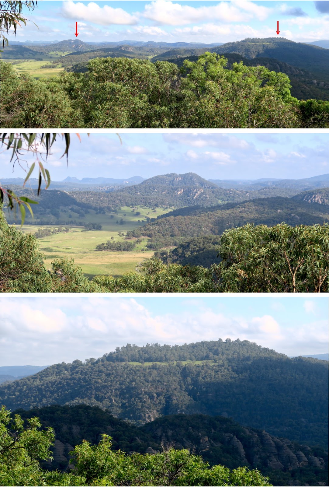
14) Nice view looking towards the north ~~~
Of the 3 pics below:
- Upper pic:
• Left red arrow: I don't know what mountain is it. Probably unnamed, but looks inviting to be climbed !
• Right red arrow: Mt Touwouwan
- Middle pic: Zooming in onto the unnamed mountain
- Lower pic: Zooming in onto Mt Touwouwan.
http://mntviews.blogspot.com.au/2016/02/mt-touwouwan-wollemi-nat-pk-nsw.html
15) Coming down from the lookout and looking back at it.

To the pagodas on north-western slope of Mt Towinhingy
From the rocky lookout in photos #13, #14 and #15, instead of retracing our steps by descending east to the car, we go west instead to explore the pagodas there.
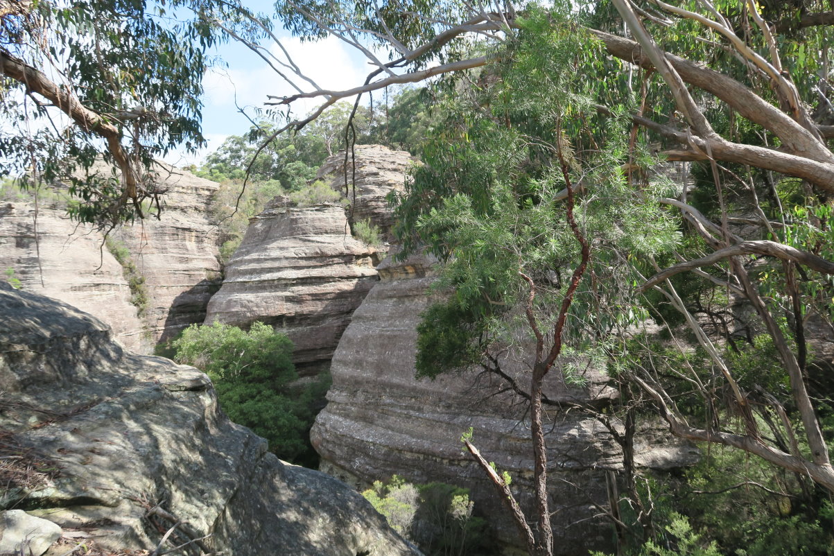
16) On the way to the pagodas, we encounter plenty of cliffs/rock formations. By comparison, the side we climbed up the mountain (east side) seems quite tame.
- The two lower photos are continuation to the right/left of each other.

17) The 2 photos below are also continuation to the right/left of each other.
- The rock formation in the 2 red circles are of the same rock.
- In the lower pic, the main rock there looks like the head of a crocodile.

Lookout to the pagodas
18) We come to a lookout marked by this rock ~~~
- In the upper pic, the mountain in the background is the same as the one in photo #14.

19) From the lookout, we have our first glimpse of the pagodas ... they are so inviting !
I would love to explore more of them one day. If you wish to do so too, please contact me.
- Upper pic: Panoramic view (The pagodas we are going to climb now are not in this pic ... they are beyond the left edge.)
- Middle pic: Zooming onto the pagodas on the left side of the upper pic.
- Lower pic: Zooming onto the pagodas on the right side of the upper pic.

In pagodas territory
20) We've come down from the lookout and are now in pagodas territory ... we are going to climb some of them, especially the highest one - the one in the red circle.

21) Inching forward towards the pagodas

22) Inching forward towards the red circle - the highest pagoda in this local area

23) Looking back at DH going over one of the many pagodas

At top of the highest pagoda
24) We reach the top of the highest pagoda in the red circle in photos #20 and #22.

25) Superb panoramic view from here ... this and the next pic. This pic is towards south-west.

26) This panoramic view is from west to north and is the continuation to the right of the previous pic.
The red arrow points to Mt Touwouwan which we climbed yesterday.

27) Google Earth view of where we are now - the red arrow. (Click on the image to enlarge it.)
- Our tracklog is in turquoise colour.

28) Towards west and zooming onto the left side of the panorama in photo #26 ~~~
Would be interesting to climb the rock formation at the centre of the pic. It is honeycombed with caves !

29) Towards north-west and zooming onto left of the centre of the panorama in photo #26 ~~~
Later on, we'll explore a little bit in that direction.

30) Towards north and zooming onto right of the centre of the panorama in photo #26 ~~~
Just like the previous pic ... the wonderful pagodas !

31) (Continuation to the right of the previous pic) ~~~
This one is zooming onto the right side of the panorama in photo #26.

32) (Still at the top of the highest pagoda)
Some close by pagodas

Explore towards north-west
After a short stop at the highest pagoda, we now explore towards the north-west.
33) We go down a passage between 2 pagodas ... the yellow arrows ... this pic is looking backward.
- The pagoda on the left is the one in photo #31.
- On the right is where we have been ... the base of the highest pagoda in this area.

34) Further along our exploration ... we are heading down this gully.

35) Yellow arrow: Going down the gully of the previous pic

36) Down in the gully of the previous pic and looking back ~~~
You can just make out DH bashing through the scrub in the middle of the pic.

37) At the end of the gully and looking back at it.
The red arrow points to the highest pagoda in this area. We were there in photos #24 to #32.

38) Continuation to the right of the previous pic ~~~
The red arrow points to the highest pagoda ... we were there ... photos #24 to #32.

39) Now closer to the rock formation seen in photo #28

40) Closer still to the rock formation

41) Zooming onto the rock formation ~~~
Would love to climb it. But it is not so easy ... there is a big drop just in front of it and we don't have time to explore around to find a way up. Will have to be next time :-(

42) Red circle: The rock formation of the previous pic as seen in Google Earth.
(Our tracklog is in turquoise colour.)

43) Around where we are in photos #40 and #41, looking back at where we came from:
- The red square is the pagoda in photos #31 and #33.
- The rectangle has the pagodas in photo #38.
- Red arrow points to the highest point of the pagodas ... we were there in photos #24 to #32.

44) Zooming onto the red rectangle of the previous photo ~~~
The red arrow points to the highest point of the pagodas ... we were there in photos #24 to #32.

45) Nearby rocks

46) We try to go down this mini gully ...

So we backtrack to find another way forward.
47) Nearby pagodas
48) Exploring the pagodas

49) Another nearby pagoda ... no, we do not have time to climb it.
This is as far north-west as we go. In the afternoon we intend to climb a nearby Sheridan Hill, hence we need to return to our car now.

Return to car
50) On the return trip, we keep to higher grounds. This pic is reminiscent of photo #43.
- The red arrow points to the highest point of these pagodas, we were there in photos #24 to #32.
- The yellow arrows mark the gully where we walked earlier on.

51) Zooming onto the left side of the previous pic.

52) We are now outside the pagodas territory, but the terrain is still interesting.

53) On the way to the car ~~~
The lower pic is the right side of the upper pic.

54) Passing by more rock formations on the way to the car

Afternoon
In the afternoon, we go on to climb the nearby Sheridan Hill. Photos and trip report are in my blog:
http://mntviews.blogspot.com.au/2016/02/sheridan-hill-wollemi-nat-pk-nsw.html
Post Script
Mt Towinhingy is a fascinating place. We have only visited a small fraction of its pagodas ... so much of them remain to be explored ... and probably no one has ever set foot on most of them. As a rule, I don't repeat a trip ... but this mountain is worth repeating! Contact me if you wish to join in too.
No comments:
Post a Comment