2016 March: Donkey Mountain (North-East Maze), Gardens of Stone National Park, NSW, Australia
Prolog
The first time I climbed Donkey Mountain was 2 months ago with DH in 2016-01. It was love at first sight. At the time we only have time to explore the west side. So this time, with NC, FM and RZ, we go to explore the east side ... appropriately called the North-East Maze, as indeed it is a maze to which you'll agree if you've ever been there.
Most seasoned Sydney/Blue Mountains bushwalkers have been up at Donkey Mountain a few times already. This is only my 2nd time.
But I'm catching up ... I will be up here again 5 months later in 2016-08 with the great man Geoff Fox. Photos and trip report of the 3rd climb are in my blog:
http://mntviews.blogspot.com.au/2016/08/donkey-mountain-north-east-maze-gardens.html
By the way, photos and trip report on my first climb are in my blog:
http://mntviews.blogspot.com.au/2016/01/donkey-mountain-west-side-gardens-of.html
Donkey Mountain
If you want to spend days in a fairyland for big kids,
climbing pagodas one after another,
or hopping over deep fissures,
or walking through canyons / slots,
or just sitting around marveling at the views of the valleys below,
then there is no other place than Donkey Mountain !
From the map, it looks as if one can traverse the top of the mountain in no time, as the distance is only about 1 km. But that 1 km is pack full of intricate topography ... pagodas, canyons, fissures, narrow passages, caves, chambers, ..., that you really need to spend a few days to fully explore the place, and appreciate the wonders of Donkey Mountain.
Maps
- 1:100,000 scaled 8931 Wallerawang
- 1:25,000 scaled 8931-4S Ben Bullen
- Plus Geoff Fox's sketch maps on Donkey Mountain. You can find them in:
• North-East Maze: https://drive.google.com/file/d/1mct9EyciXIsuNRhYBBb8ruXAvx3Y7QKb/view?usp=sharing
• Middle section: https://drive.google.com/file/d/1TmL64pz2iHOGqCpkf8vaM08V7e2tiNIk/view?usp=sharing
In the following trip report, "sketch map" refers to the North-East Maze sketch map ... unless specified otherwise.
Below is the relevant part of the 1:25,000 scaled map. (To enlarge the map, click on it.)

GPS tracklog file & Route
The GPX tracklog file of our walk can be downloaded from:
https://drive.google.com/file/d/0B877-h5SCJaSTjB4X1poVnhwWjg/view?usp=sharing
Here is our tracklog, red colour, clockwise circuit, superimposed on the 1:25,000 map.
Starting point of the walk is at upper-right hand corner, near junction of Wolgan Road and access road to Emirates One&Only Resort.

Satellite view of our clockwise circuit:

A summary of our route is:
1. Start near the junction of Wogan Road and the access road to Emirates One&Only Resort (upper right hand corner of the above map)
2. To Sandy Overhang (Names like this are in Geoff Fox's sketch diagram.)
3. To Jenny Craig
4. To Green Room
5. To Green Room Portal
6. Back to Green Room
7. To Kents Crevasse entrance
8. To Grand Hall
9. To cliff above Donkey Canyon
10. To Donkey Canyon
11. To Wolgan Window
12. To a pagoda lookout south of Donkey Canyon
13. To Titanic Canyon and pass through its north tunnel
14. To a pagoda lookout south of Fern Gully
15. To a pagoda lookout south of Resort View 1
16. Back to Titanic Canyon, this time pass through its south tunnel
17. Return to car
The above numbers correspond to the numbers in the satellite view below:
(Note: "13" in the satellite view refers to our entries into both the north & south tunnels of Titanic Canyon.)

Timeline & Distance
09:23 0.0 km Start near the junction of Wogan Rd and access road to Emirates One&Only Resort
10:03 1.7 km Stop for a rest
Rest
10:15 1.7 km Resume walking
10:28 2.0 km Stop for morning tea
Morning tea
10:36 2.0 km Resume walking
11:01 2.4 km At Sandy Overhang (Names like this are in Geoff Fox's sketch diagram.)
11:09 2.6 km At entrance to Jenny Craig
Inside Jenny Craig
11:27 2.7 km Back at entrance of Jenny Craig
11:35 2.8 km At entrance to Green Room
Explore inside Green Room
11:48 2.9 km Exit Green Room (towards Green Room Portal)
11:52 2.9 km At Green Room Portal
Explore around Green Room Portal
11:57 2.9 km Leave Green Room Portal (towards Green Room)
12:01 3.0 km At Green Room
12:08 3.0 km out of Green Room and at the same spot as at 11:35
12:29 3.5 km At entrance to Kents Crevasse
12:29 3.5 km Turn around, retrace steps
12:34 3.6 km End of retracing steps, turn west towards Grand Hall
12:37 3.7 km At Grand Hall
Lunch inside Grand Hall
13:20 3.8 km Leave Grand Hall
13:27 3.9 km At cliff above Donkey Canyon
Looking down at Donkey Canyon
13:32 3.9 km Leave cliff above Donkey Canyon
13:37 4.0 km At entrance which descends down north-east side of Donkey Canyon
13:43 4.1 km At start of north branch on west side of Donkey Canyon
13:45 4.2 km At entrance to a narrow slot to Wolgan Window
At Wolgan Window
13:48 4.2 km Back at entrance to Wolgan Window
13:53 4.3 km At a pagoda lookout south of Donkey Canyon, west-south-west of Arrow
14:00 4.4 km Arrive at Titanic Canyon
14:16 4.5 km Exit Titanic Canyon, north tunnel, I think???
14:25 4.7 km At a pagoda lookout east of Snow Chute and south of Fern Gully
14:38 4.7 km Leave lookout
14:57 5.1 km At a pagoda lookout south of Resort View 1 ... this is as far east as we go
Afternoon tea
15:09 5.1 km Leave lookout
15:41 5.8 km At start of south branch on west side of Donkey Canyon
15:43 5.8 km Back at Titanic Canyon
15:52 5.9 km Exit Titanic Canyon, south tunnel, I think???
16:10 6.1 km Descending Donkey Mountain
17:41 9.2 km Back at NC's car
==============================================
Total: 8 hrs 18 mins
9.2 km Distance is from Google Earth
12.0 km Distance is from Garmin GPS
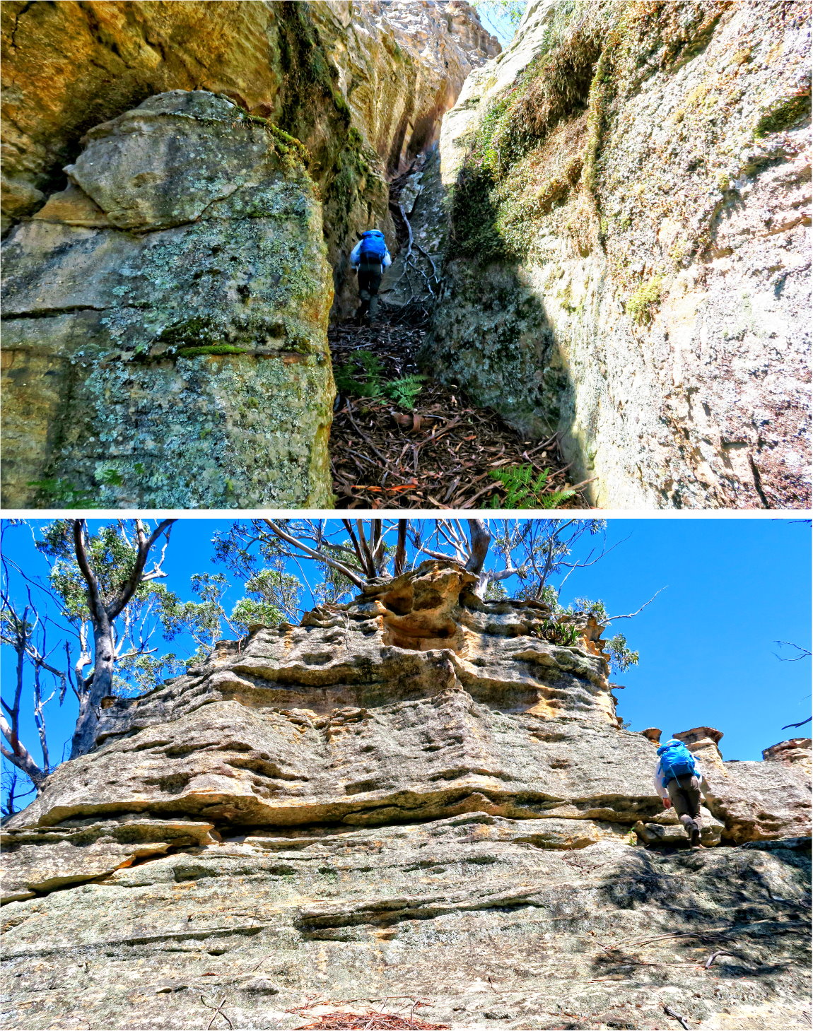
Pictures - Donkey Mountain
1) We are looking at the north-east side of Donkey Mountain, the shorter side. The yellow dots and arrows in both the upper & lower pics are our route up the mountain.
Upper pic: Taken near the start of our walk ... Left of Donkey Mountain is an unnamed hill east-north-east of the mountain.
Lower pic: Taken after we've just passed the unnamed hill of the upper pic.

A lookout on Donkey Mountain
2) We've climbed up to the plateau of Donkey Mountain without fuss. Here, we come to a lookout.
Left to right: RZ, FM, NC

3) This panorama from the lookout is towards north, specifically from north-west to north-east.
The red square on the right is shown in full in photo #4. NC's car is parked somewhere there.

4) This photo is the red square of the above pic.
And we can see NC's car in the red circle ! :-)

Sandy Overhang
5) We come to a cave labelled Sandy Overhang in Geoff Fox's sketch map.
- Upper pic, left to right: Me, RZ, FM (photograph courtesy of NC)

Jenny Craig - the western entrance
6) Next, we come to the western entrance of a very narrow slot named Jenny Craig in Geoff Fox's sketch map. (Photograph courtesy of NC)

Inside Jenny Craig
The slot is called Jenny Craig because if you haven't been through a Jenny Craig program, you won't be able to pass through it :-) ... see the next set of photos.
(Jenny Craig is a weight loss, weight management and nutrition company founded in 1983 by Jenny Craig and her husband, Sidney Craig. The program was started in Melbourne, Victoria, Australia and began operations in the United States in 1985. Today, the company is headquartered in Carlsbad, California, USA.)
From end to end, the length of Jenny Craig is about 75 meters - a most memorable slot that should be experience at least once in your life !
5 months later, in 2016-08, I will return to Donkey Mountain in a trip led by the great man Geoff Fox ...
... See this link: http://mntviews.blogspot.com.au/2016/08/donkey-mountain-north-east-maze-gardens.html
We will drop our backpack at the western entrance. Go around the rocks to the eastern entrance (via Green Room and Green Room Portal). Then enter Jenny Craig and squeeze through its entire length to emerge out at the western end. That was real fun ! ... See photos #27 to #30 in the above link.
7) The Jenny Craig slot is so narrow that we have to walk side ways like a crab.
- Upper pics: Left to right: NC and I
- Lower left pic: Somewhere in the middle of Jenny Craig is a even narrower side branch named as Julie Craig by Geoff Fox. However, it leads to a dead end. Nonetheless RZ goes in to explore. She definitely would pass any slimness test with distinction !
- Lowe right pic: FM inside Jenny Craig (Photograph courtesy of NC)

8) - Left pic: At roughly the middle part of Jenny Craig, the passage widens a little.
- Right pic: This pic is looking at the rest of the Jenny Craig slot and is taken at where FM & NC were standing in the left pic. If we keep going, we will be able to exit the slot at its eastern entrance. From there we can go around the rocks and return to the western entrance in a circuit. But we decide not to go forward. Instead, we turn around here.

9) We turn around and back track out of Jenny Craig.
- NC is the guy in both pics

And then we are out of Jenny Craig ... phew, what an experience !
Around western entrance of Jenny Craig
10) Scenery around the western entrance of Jenny Craig

11) Just south of Jenny Craig is this slot. We go in to have a look. But it looks like a dead end.

Green Room
12) We now arrive at the entrance to Green Room. The entrance is south of where the previous pic was taken.

13) This is it, the Green Room ... it is labelled in Geoff Fox's sketch map.
- Red circle: Chockstone ... see photo #15
- Red long oval: A vine that goes all the way to the top of the cliff ... see photo #14.

14) The vine here is the one in the red long oval of the previous pic. We are posing as Tarzan for the camera, not trying to climb up the cliff :-) But now I'm curious ... Has anyone actually climbed up to the top this way?

15) We explore the Green Room as far as where the chockstone is. I'm now wondering whether it is possible to keep going and climb out of the Green Room that way? Anyway, we turn around here.

16) Looking back into the Green Room ~~~
- Left pic: Taken from near the chockstone of the previous pic
• Yellow arrow: Entry to Green Room Portal ... we are going there next ... see photo #17.
• Long red oval: The climbing vine.
• At end of the cliff near the climbing vine, there is a passage to the left (you can't see it in the pic) ... that was how we entered Green Room.
- Right pic: Retracing our steps in the Green Room: A close-up view of the vine is on the left ... the same vine as in various previous pics.

Green Room Portal
17) We are entering Green Room Portal via this connecting slot. The slot is under Tchaikovsky Ledge in Geoff Fox's sketch map.
- To help visualize the interior of the slot, the stones in the 2 red circles are of the same stone. And they are also the same stone as the ones in photo #21 viewed from opposite directions.
- Middle pic, NC finds it easier to climb down backwards.

18) Onto Green Room Portal in Geoff Fox's sketch map

19) We emerge out of Green Room Portal ~~~
- Left pic: Scenery on the left side of Green Room Portal
- Right pic: Scenery on the right

http://mntviews.blogspot.com.au/2016/08/donkey-mountain-north-east-maze-gardens.html
We now turn back to re-enter Green Room Portal, then back into Green Room.
20) The scene here is the same as in photo #18, viewed from the opposite direction.

21) Back in the same connecting slot between Green Room Portal and Green Room (under Tchaikovsky Ledge) ... the same one as in photo #17.
- To help visualize the interior of the slot, the stones in the 2 red circles are of the same stone. It is also the same stone as the ones in the red circles in photo #17, viewed from opposite directions.
- Right pic: NC climbing out of the slot. It is the same spot as the middle pic of photo #17 where NC has just climbed down.

Exit Green Room
22) We are retracing our steps out of Green Room. The scenes here are the same as the ones in the lower pics of photo #12.

Scenery along the way to Low Cave
23) - Left pic: Wonderful scene along the way
- Right pic: Cliff at the end of the passage of the left pic.

24) So many of these narrow passages ... so typical of Donkey Mountain ... no wonder people come up here so often !

25) This and the above 2 pics are taken at the same spot, but this pic is looking backwards.

Low Cave
26) At Low Cave, quite an interesting cave ~~~
The 2 lower pics are continuation to the left/right of each other.

Explore area south-west of Low Cave
27) We now explore an area south-west of Low Cave
- Upper pic: We come to a another narrow passage.
- Middle pic: We go up to check it out.
- Lower pic: We turn around, and consult the map on where to go next.
- The fallen tree trunk in the 2 red ovals below are of the same trunk.

On Freeway to the entrance of Kents Crevasse
"Freeway" is labelled in Geoff Fox's sketch map as the route between the interesting rock formation of the following photos to Kents Crevasse.
28) Most probably Geoff Fox has given a name to this rock, but it is not labelled in his sketch map. I wonder whether this rock is climbable ... if not to the top, then to that interesting gap near the top ???
- The red rectangle on the left side of the middle pic is the rock formation in photo #29.

29) This rock formation is the same as the one in the red rectangle in photo #28, middle pic.

30) More interesting rock formations

Entrance of Kents Crevasse
You can find Kents Crevasse in Geoff Fox's sketch map. Its entrance is a hole ... see the photos below.
5 months later, in late 2016-08, I will be here again with a party led by Geoff Fox. We will enter Kents Crevasse which leads up to a pagoda, the top of which is a wonderful view towards west and north. Photos and an account of that trip are in my blog:
http://mntviews.blogspot.com.au/2016/08/donkey-mountain-north-east-maze-gardens.html
In today's trip, we only go as far as the entrance hole. We don't even bothered to peep into it ... we don't know there are goodies inside !
31) The hole in the red circle is the entrance to Kents Crevasse ... inside, it is like a chimney !
- But we didn't enter the hole :-(
- We also didn't go further forward, as otherwise we'll be going down Donkey mountain and will end up in Wolgan Road. Nah, the day is still young, we still have more to explore, so we turn around here.

To Grand Hall
32) We've turned around and are now retracing our steps along the "Freeway". It is refreshing to look at the rock formations along the "Freeway" in the opposite direction.

33) More narrow slots ... well, what do you expect in Donkey Mountain !?!
- Left pic: We are walking towards a cavern labelled Grand Hall in Geoff Fox's sketch map.
- Right pic: Just about to enter Grand Hall

Grand Hall
34) Arrive at Grand Hall ... a wonderful spacious cavern with a level floor covered with fallen leaves.
- Upper left pic: RZ looking into a very narrow slot ... more about it in photo #37
- Lower right pic:
• Where RZ is facing is where we'll leave Grand Hall later on ... after having lunch first.
• I'll enjoy my lunch on top of the rock in the red circle ... the same rock as in the larger red circle in photo #36.

35) Compared to the previous photos, I am now looking at Grand Hall from the other end.
- The yellow arrow is how we entered Grand Hall ... from the narrow slot
- In the red oval, there is a recess. Inside is a plastic box with a log book ... see the lower photo.
- Also, somewhere around the red oval is a very narrow slot ... see photo #37.

36) Similar scene as the upper pic of photo #35 ~~~
- The rock in the bigger red circle is where I'll soon sit down to have lunch. It is the same rock as the one in the red circle in the lower right pic of photo #34.
- Upper pic: There is a fire place at the lower right corner. The middle pic zooms onto it.
- Middle pic: Inside the two red circles are candles.
- Lower pic: The candle here is the one in the smaller red circle in the upper pic.
We didn't place any candles here. It looks like someone has been camping here recently. I'm not surprised, this is a perfect place to spend the night !

37) Freda lying on Freda's Chair discovered by Freda :-)
- Left pic: Around where the log book is located, there is a very narrow slot that leads to nowhere.
- Right pic: Inside is a hollowed out space in the wall which looks like a reclining chair. In the pic below, FM is lying on it. Geoff Fox named it Freda's Chair ... in honour of FM who discovered it ... Freda being FM's first name. The story goes that Geoff had named it Freda's Bedroom. Then changed it to Chair as he thought Bedroom didn't sound nice. Ah, Geoff, you are a gentleman ... I would stick to Freda's Bedroom ... sounds sexier ! (Photograph courtesy of NC)

Leave Grand Hall
Lunch is over, time to leave Grand Hall (going to Donkey Canyon next). In photo #34, lower right pic, where RZ is facing is where we leave Grand Hall.
38) - Left pic: The narrow slot through which we leave Grand Hall
- Right pic: Out of Grand Hall.

Cliffs above Donkey Canyon
39) Before going to Donkey Canyon, we detour to the cliffs above it. It is nice lookout.
- The red arrow points to an unnamed hill west-south-west of Donkey Mountain.

40) RZ, NC and I are looking down into Donkey Canyon.
(Photograph courtesy of NC)

Donkey Canyon
41) - Left pic: We are at the north-eastern end of Donkey Canyon. To enter it, we need to climb down as FM is doing now.
- Right pic: I am now standing near where FM was in the left pic and looking down at the entry into Donkey Canyon. To reach the canyon, climb down towards NC (who is taking photos), then turn right.

42) Donkey Canyon - level ground covered with fallen leaves (I am at NC's spot of the above pic.) ~~~
It is like a fairy land, another wonderful place in Donkey Mountain.

43) Walking further into the canyon (pass the fern in the middle of the canyon of the above pics.)

44) Looking back ~~~
- Left & middle pics: We entered Donkey Canyon from the left and behind the moss covered rock in the red circle. This moss covered rock also features in photo #42.
- Right pic: We climb up and out of Donkey Canyon and are now looking back down at it. You should be able to match some of the plants here with the corresponding plants in the previous pic, photo #43.

North branch on the west side of Donkey Canyon
45) After climbing up and out of Donkey Canyon (above right pic), we are in the north branch on the western side of Donkey Canyon.
- In the sketch map at lower-left-hand corner, I'm at the red dot looking towards the west.

46) To exit out of this north branch, need to go pass this rock blocking the middle of the passage. You can either squeeze through the narrow gap on the left, or crouch down to crawl through the hole on the right. RZ wants to test her slimness, so she goes through the gap instead. As expected, she passes the test with distinction. However the gap is so narrow that halfway through she has to take off her backpack.

Detour to Wolgan Window
After we exit out of the north branch (previous pic), we are then in Titanic Canyon. What we want to do now is to go to the tunnels on the western side of the Canyon. But first, we make a detour to Wolgan Window.
Wolgan Window (in Geoff Fox's sketch map) is at the end of a narrow slot which has a good view to a conical-shaped unnamed hill west-south-west of Donkey Mountain.
The story goes that the unnamed hill is actually Mt Wolgan. However, the cartographer placed the label "Mt Molgan" wrongly at the west end of Donkey Mountain, hence the hill is now unnamed ... haha !
47) Inside Wolgan Window ~~~
- Left pic: Towards the end of the narrow slot
- Middle pic: At Wolgan Window ... It has a good view of the above mentioned unnamed hill. This is as far as we can go in the slot.
- Right pic: Backtracking out of the narrow slot

To lookout on top of a pagoda south of Donkey Canyon
48) After Wolgan Window, while NC & FM are having a rest, RZ and I go on to climb a nearby pagoda which is situated south of Donkey Canyon and west-south-west of Arrow. (Arrow is a label to a pagoda in Geoff Fox's sketch map.)
49) The top of the pagoda has a nice panoramic view.
- Upper pic: Towards west ... the 2 red arrows point to, from left to right:
• Unnamed hill west-south-west of Donkey Mountain, the same one as in photo #47
• Cape Horn
- Lower pic: Towards north ... typical Donkey Mountain topography, pagodas and pagodas !

- 3 months later in 2016-06, from the south ... photos and trip report are in my blog:
http://mntviews.blogspot.com.au/2016/06/cape-horn-lawler-point-lawler-caves.html
- 8 months later in 2016-11, from the west ... photos and trip report are in my blog:
http://mntviews.blogspot.com.au/2016/11/cape-horn-lawler-point-wolgan-state.html
50) This one is found growing on the pagoda - Leucochrysum graminifolium (Pagoda Rock Daisy). They only grow on the pagodas around Gardens of Stone / Wollemi National Parks area. You won't find them anywhere else in the world !

Titanic Canyon - north tunnel
51) After all the detours, we finally arrive at start of the Titanic Canyon tunnels.

52) There are 2 tunnels through the western side of Titanic Canyon. According to my GPS, we go through the south tunnel first; later on we'll return to go through the north tunnel. But my memory says we go through the north tunnel first. For once, I think my memory is correct ... Too many high cliffs around here to make the GPS recordings unreliable.

53) A fantastic place to pass through.

54) Imagine, my turn to follow NC next !!! This tunnel is exciting ... like in a magical world !

55) - Left pic: I can't remember how I managed to get down from such a height !!!
- Right pic: We entered the tunnel from the east side. Now we exit here at the western side.

56) We exit out from here, the western entrance of the tunnel in Titanic Canyon.

Lookout on top of a Pagoda
57) After Titanic Canyon, we climb up this pagoda ... east of Snow Chute and south of Fern Gully in Geoff Fox's sketch map on the Middle Section of Donkey Mountain.
- Lower 2 pics: The are continuations to the left/right of each other.

58) Wonderful panorama from the lookout
- Upper pic:
• Emirates One&Only Resort is in the red square, towards south.
• The red arrow points to the end of Nobles Canyon, a memorable canyon every Australian should walk through once in their life time ! I did it six months ago, in 2015-09. Photos and trip report are in my blog: http://mntviews.blogspot.com.au/2015/09/deception-nobles-canyon-wollemi-np-nsw.html
- Lower pic: Zooming onto Emirates One&Only Resort ... the red square of the upper pic.

59) Continuation to the right of the previous panorama ~~~
The red arrow points to the highest point of Donkey Mountain. It is not climbable without climbing gears.

60) Isopogon, a Drumsticks plant ... Is it Isopogon anemonifolius (Broad-leaf Drumsticks)?

61) Time to leave the lookout

To a pagoda south-west of Resort View 1
62) We are going to another lookout on top of another pagoda :-)
There are many wonderful scenery and rock formations along the way. It is not possible to show all the interesting photos here. So I'll just randomly post a few here. They really don't do justice to the intricate topography of Donkey Mountain.

Pagoda lookout south-west of Resort View 1
The pagoda we are going to is just south-west of a label called Resort View 1 in Geoff Fox's sketch map on the Middle Section of Donkey Mountain.
63) - Left pic: Before we reach the pagoda, first climb up this rock face. RZ is leading. NC is behind her. They climb up from the left edge of the pic, the yellow arrow there. I'll follow suit next. But a less exposed/dangerous way up is via a very narrow gap pointed to by the yellow arrow on the right ... discovered by FM. She'll squeeze through there later on.
- Right pic: On the return leg, we all squeeze through that gap. Here is me in action ... need to take off the backpack to get through. (Photograph courtesy of NC)

64) We are now at the top of the pagoda ~~~
This pic is toward east ... What a wonderful scene of the other pagodas ! Geoff Fox's sketch map on the Middle Section of Donkey Mountain has a path that goes to a label marked as "Eastern View". In this pic, it is the right most rock ledge of these pagodas. I'll be there 5 months later in 2016-08 ... see photos #71 to #74 in this link:
http://mntviews.blogspot.com.au/2016/08/donkey-mountain-north-east-maze-gardens.html
- The pagoda in photo #57 is somewhere on the left half of the pic and behind the pagodas. I just can't pin point exactly where it is :-(
- The red arrow points to a lookout I was at 6 months ago in 2015-09. It has a wonderful view of both the resort and Donkey Mountain. Photos and a report on the 2015-09 trip are in my blog:
http://mntviews.blogspot.com.au/2015/09/deception-nobles-canyon-wollemi-np-nsw.html

65) Continuation to the right of the previous pic ~~~
- The cluster of buildings on the left edge and near the centre belong to Emirates One&Only Resort.
- Photo #58 zooms in onto the resort near the centre of this pic.
- Of the 2 red arrows, the one on the left edge points to a lookout I was at 6 months ago in 2015-09. It has a wonderful view of both the resort and Donkey Mountain.
- The other red arrow points to the end of the wonderful Nobles Canyon.

66) Continuation to the right of the previous pic ~~~
- We have afternoon tea here ... NC is relaxing and enjoying the scenery.
- Red Squares in both upper & lower pics: The two squares mark out the same area with identical pagodas inside.
- Red arrow: Highest peak in Donkey Mountain, not climbable without climbing gears
- Red circle in the lower pic: 2 months ago, in 2016-01, DH and I climbed Donkey Mountain from the west. The pagoda in the red circle was as far east as we went on that day. And we climbed to its top too ... as it may well be the 2nd highest peak in Donkey Mountain. It is about 30 or so meters from where I am standing now, but we won't be going there today. Where we are now is as far west as we intend to go for the day.

http://mntviews.blogspot.com.au/2016/01/donkey-mountain-west-side-gardens-of.html
In particular, photos relating to the pagoda in the above red circle are in photos #48 to #51 of the blog.
67) RZ & NC relaxing on top of the pagoda

68) FM & RZ - two very lovely ladies !

Return to Donkey Canyon
We now return to the Donkey Canyon, and thence to Titanic Canyon.
69) - Left pic: Taken somewhere south of Titanic Canyon when we are on our way to Donkey Canyon.
- Middle pic: South branch on the western side of Donkey Canyon. In the sketch map, I'm at the red dot looking towards north-east. The end of this passage is the western end of Donkey Canyon.
- Right pics: Just about to enter the north branch on the western side of Donkey Canyon.

70) After passing through the gap in the above right pic, we are now in the north branch on the western side of Donkey Canyon ~~~
- In the sketch map at lower-left-hand corner, I'm at the red dot looking towards the west.
- NC leading, followed by RZ & FM
- This is the same scene as photo #45.

Titanic Canyon - south tunnel
71) We are out of the north branch and into Titanic Canyon ~~~
The 3 pics here are almost identical to the 3 pics in photo #51.
- In the lower left pic, FM & NC are consulting Geoff Fox's sketch map.

72) As mentioned already, there are 2 tunnels through the west side of Titanic Canyon. In photos #52 to #55, we went through the north tunnel. Now, we are going through the south tunnel. (Although my GPS says I'm in the north tunnel, but I think the GPS is wrong due to too many high cliffs around.)
- Left pic: NC is in front.
- Right pic: Looking back FM just entering the tunnel

73) - Left pic: Typical RZ, leaving no cliff unclimbed ... she is climbing up to check what is up there. The rest of us go through the gap on the right.
- Right pic: This is the scene after we turn into the gap in the left pic. NC is sitting at the exit of the tunnel.

74) Leaving the tunnel

Climbing down Donkey Mountain
75) The day has come to an end ... time to leave. The 2 pics below are of the same spot, it is where we climb down Donkey Mountain. (This morning, we climbed up Donkey Mountain from the east. Now we go down heading north, straight towards Wolgan Road.)

76) When climbing down, we notice this stone wedged between two tree branches. It must have tumbled down from higher up the cliff and just wedged itself here ... amazing !

77) In the Blue Mountains, termite mounds are yellow and large. Donkey Mountain is in Gardens of Stone National Park which adjoins Blue Mountains; but this termite mound is black and small ... something to do with the soil.

78) We've reached the plain at the foot of Donkey mountain. Plenty of this flower amongst the grass. If you know its name, please let me know.

79) Looking back at Donkey Mountain from the plain ~~~
- The yellow arrow is the way we came down the mountain.
- We climbed it this morning from the left, going up along and just behind the ridge. (In photo #1, we can see our ascent route, but not here ... because now we are situated further towards the west.)

Post Script
Donkey Mountain deserves several visits. I will be up there again 5 months later in 2016-08, with the great man Geoff Fox, "King of Donkey Mountain", as he has been up there more than 50 times!!! He will take us to places that by ourselves we wouldn't know how to get to, or we wouldn't know what places are interesting ... places like:
- Bermuda Triangle ... It took Geoff a few years to figure out a way there. So what hope is there for a mortal soul like me to find my way there !
- Kents Crevasse ... In this trip, we reached its entrance. But we didn't venture in ... didn't know there were goodies inside!
Photos and trip report of this later trip to Bermuda Triangle, Kents Crevasse, and other interesting places are in my blog:
http://mntviews.blogspot.com.au/2016/08/donkey-mountain-north-east-maze-gardens.html
No comments:
Post a Comment