2016 April: A day-walk on Gladstone Pass, Lindeman Pass and Copeland Pass in NSW Blue Mts, Australia
Book on Gladstone Pass, Lindeman Pass, Copeland Pass
"The Blue Mountains Mystery Track: Lindeman Pass" by Jim Smith
Gladstone & Copeland Passes
When MK and I traversed the entire length of Lindeman Pass 4 months ago in 2015-12, we walked past the junctions where Gladstone and Copeland Passes meet up with Lindeman Pass. I remember peering into them and could make out faint trails fading into the scrub. And that was how I became interested in exploring the two passes ... and invited MK to join in.
Both passes turn out to be quite interesting:
Gladstone Pass:
- There is a narrow, steep and wet section. Fortunately there are ropes you can hang onto ... photos #6, #7, #8.
- I'll be going down Gladstone Pass again about 2 years later, in 2018-08 ... Refer to my blog:
http://mntviews.blogspot.com/2018/08/lawbeck-pass-gladstone-pass-gladstone.html
Copeland Pass:
- It is even steeper, see photo #35. And the route up is exposed. Again, fortunately there are ropes to assist you. But still, if you are afraid of height, Copeland Pass is not for you.
By the way, photos and report on our earlier trip along Lindeman Pass are in my blog:
http://mntviews.blogspot.com.au/2015/12/roberts-pass-lindeman-pass-prince-henry.html
Maps
• 1:100,000 scaled 8930 Katoomba
• 1:50,000 scaled Blue Mountains South by Spatial Visions Innovation, 1st edition
• 1:25,000 scaled 8930-1S Katoomba
• Black & white sketch map of Gladstone, Lindeman & Copeland Passes by Jim Smith can be downloaded from:
https://drive.google.com/file/d/0B877-h5SCJaSZXl4eV9WTmZUcUE/view?usp=sharing
• Scroll forward to photo #20 for Smith's sketch map around Sublime Point.
Here is the 1:25,000 scale map of the relevant part of today's walk.

GPS tracklog file & Route
Our GPX tracklog file can be downloaded from:
https://drive.google.com/file/d/0B877-h5SCJaSMWY5S0ZpQTVZZ3M/view?usp=sharing
Here is our tracklog, red colour, clockwise, superimposed on the 1:25,000 map.
The small blue circle near the top of the map is where I park the car and start the walk.

Satellite view:

A summary of our route is:
- Park car at junction of Sublime Point Rd & Fairmont Pl (just outside the front entrance to Fairmont Resort at Leura)
- On Gladstone Pass
- On Lindeman Pass
- At the southern most tip of Sublime Point, turn north into Copeland Pass
- To Sublime Point Lookout
- To Sublime Point tourist carpark
- Walk on Sublime Point Road back to the car
Timeline & Distance
11:03 0.0 km Start at Sublime Point Rd, just outside the front entrance to Fairmont Resort at Leura
11:05 0.1 km At start of Gladstone Pass
11:53 1.3 km End of Gladstone Pass, start of Lindeman Pass
11:55 1.4 km At Dash's Cave
12:08 1.4 km Leave Dash's Cave
13:20 3.9 km At junction of Lindeman & Copeland Passes at southern tip of Sublime Point
Morning tea
13:25 3.9 km Start to climb up Copeland Pass
14:24 4.8 km At Sublime Point Lookout
Lunch
14:54 4.9 km Leave Lookout
14:56 5.1 km At Sublime Point carpark
15:13 7.0 km Finish at front entrance to Fairmont Resort at Leura
==============================================
Total: 4 hrs 10 mins
7.0 km Distance is from Google Earth
6.7 km Distance is from Garmin GPS
Pictures - Fairmont Resort
1) Fairmont Resort entrance at Leura (junction of Sublime Point Road and Fairmont Pl) ~~~
This is where we park our car. The start of Gladstone Pass is about 75 meters in from the entrance.

Gladstone Pass
2) Start of Gladstone Pass at Fairmont Resort in Leura ~~~
The sign says:
This track is an historic route which is rough and indistinct in places.
Please do not proceed unless accompanied by an experienced navigator.

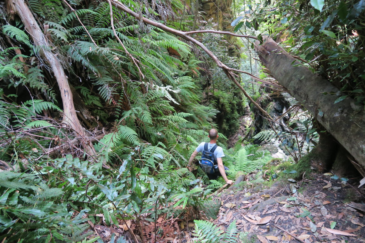
3) Gladstone Pass ~~~
The trail is easy to follow, not as bad as the sign in the previous pic had warned.

4) We have just scrambled down these rocks.

5) The Gladstone pass is getting steeper. Now we are going down the gap between two cliffs.
6) The pass is getting exciting too ... some kind soul had installed ropes (in the red ovals) to help us hikers.

7) Gladstone Pass must be the wettest of the dry passes in the Blue Mountains. The weather has been fine for the past few days, yet the rocks along this section is wet. Without the assistance of the rope, it would be dangerous to climb down here ... too slippery; one mishap and you can be dead.

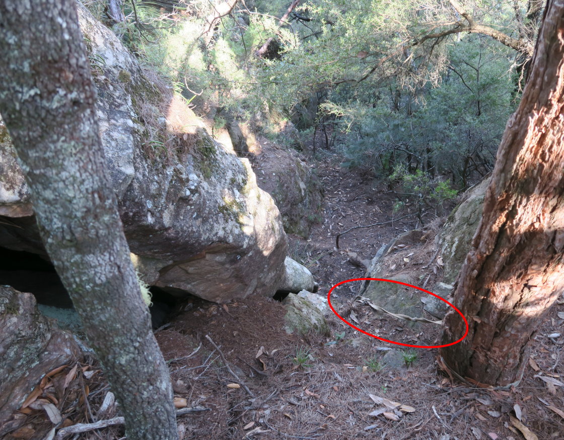
8) We've climbed down the cliff to where the rope of the previous pic ends; and now looking back up the pass.
- The base of the tree trunk in the red circle is the one as in the previous pic.
- You can see the rope along the left edge of this photo ... we had been holding on to it in the previous pics.

9) The rest of the Gladstone Pass is not so steep. The following 3 pics are the scenery along the way.
By the way, in this part of the pass, keep to the left (east) side ... a faint track is on that side.

http://mntviews.blogspot.com/2018/08/lawbeck-pass-gladstone-pass-gladstone.html
Lindeman Pass
10) We've come to the end of Gladstone Pass. This pic is Lindeman Pass.
I walked on Lindeman Pass with MK 4 months ago in 2015-12. Photos along the pass are in my blog:
http://mntviews.blogspot.com.au/2015/12/roberts-pass-lindeman-pass-prince-henry.html
(photo #10 onwards)

Dash's Cave
11) Just a bit west of Gladstone's Pass is Dash's Cave ~~~
There is a rusty billy near the centre of this pic. Photo #12 zooms onto it.

12) In the cave, we find a rusty billy with a log book inside, but not the tobacco tin :-)
We log our trip:
3/4/16 MK Gladstone -> Copeland
Paul Ma (again)
(Click on the image to enlarge it.)
Above our entry are the names of a group of NPA (National Parks Association of NSW) hikers who walked through here a week ago. Two names stand out: Jim Romanowski & Nicola Le Couteur. It is a small world, because I'll be going with them to the Altar Room in Wollemi National Park 3 months later in 2016-07.

Lindeman Pass (between Dash's Cave & Sublime Point)
13) Cliffs along Lindeman Pass ~~~~
This photo is taken shortly after leaving Dash's Cave.

14) A mini-waterfall along Lindeman Pass

15) Typical trail along Lindeman Pass ... MK leading

16) Don't blame me for defacing the tree ... It is someone else who had etched my initials on the trunk. (It is the same tree in both the upper and lower pics ... viewed from different directions.)

17) Occasionally on tree trunks, there are paint dots (upper pic) and ribbons (lower pic) to mark the trail.

18) Some rock scrambling through a land-slide area

19) This little knoll is by the east side of Lindeman Pass and close to the southern tip of Sublime Point. Jim Smith labeled it as Shale Hill in his sketch map.
- Upper pic: Shale Hill as we approach it from the north
- Lower pic: The same Shale Hill after we passed it, and are now looking back at it from the south

Junction of Lindeman Pass & Copeland Pass
20) From Jim Smith's sketch map ~~~
We now come to the junction of Lindeman Pass & Copeland Pass (the red arrow) at the southern tip of Sublime Point. We'll leave Lindeman Pass, turn north to climb up along Copeland Pass.

21) There is a cairn marking the junction. We'll be climbing up along the yellow arrows, the start of Copeland Pass.
- To help you visualize the 2 pics ... the rocks in the 2 red circles are of the same rock.
- Left pic: You can see the track of Lindeman Pass curving towards the right ... because we are at the southern tip of Sublime Point; and Lindeman Pass is turning northward.

http://mntviews.blogspot.com.au/2015/12/roberts-pass-lindeman-pass-prince-henry.html )
Copeland Pass
22) The Copeland Pass track is indistinct. Not to worry, just head directly north along the top of the ridge. You can't get lost :-)

23) Not long along Copeland Pass, we come to this lookout.

24) Blue Mountains scenery from the lookout:
- Upper pic: The long mountain range on the right half of the pic is Mt Solitary (towards south).
- Middle pic: Left red arrow points to Ruined Castle, right arrow points to Castle Head (towards south-west).
- Lower pic: The Three Sisters, icon of the Blue Mountains (towards west).

25) Occasionally, there is a cairn to mark the way.

26) Here comes the 1st fixed rope to help us up.

27) Looking down at how I just climbed up ... The rope is in the red oval.
28) An interesting overhang

29) We are about to climb up a short tunnel.
Judging by the ribbon tied to a dead tree trunk on the left edge of the pic, we know we are on the right track :-) But don't rely on the ribbons for navigation as I've noticed only 4 or 5 along the entire Copeland Pass.

30) My turn now to climb up the short tunnel. In the pics, MK has already climbed up.

Copeland Pass Lookout
31) Immediately after we climbed up the short tunnel, we are at a lookout labeled as "LO" in Jim Smith's sketch map ... refer to photo #20.
The main mountain range in the background and behind the lookout is Mt Solitary.

32) Me at the lookout ... to prove I have been here :-)
- The Three Sisters is near the right edge of the pic.

33) Fantastic view from the lookout ~~~~
- The escarpment on the left half of the pic belongs to Kings Tableland.
- The long mountain range on the right is Mt Solitary, directly south.
- The large valley in the middle of the pic (south-south-east), and to the left of Mt Solitary, is where Kedumba River flows.

34) Continuation to the right of the previous pic ~~~~
- The mountain range on the left side of the pic is Mt Solitary, directly south.
- The left red arrow points to Ruined Castle, south-west-ish.
- The right red arrow points to Castle Head, west-south-west.
- Directly west is The Three Sisters in the red circle, icon of the Blue Mountains.
- The mountain range behind Ruined Castle is Narrow Neck Plateau.

35) From the lookout, looking up at where we are going next ... climb up that cliff along the yellow arrows !!!
I can hear myself mumbling, "My God, how are we going to climb it !"

Copeland Pass Lookout to Sublime Point Lookout
36) Upward we climb, and looking back down at the lookout ... we were there not too long ago.

37) Then comes the 2nd fixed rope to help us up.

38) Scrambling up ~~~~
This one is quite exposed; need to be careful here. One slip and you'll be found dead a looong looong way down.

39) Straight afterwards, it is chimneying up this hole. Fortunately someone has installed another rope here, the 3rd fixed rope we've encountered for the day. Otherwise I don't know how one can climb up.

40) MK hauls up my backpack.

41) I've chimneyed up and now looking back at the rope.
- Left pic: The tree where the rope is tied to.
- Right pic: The hole we came up from.

42) One more scramble here and the rest is easy.

43) We come to the end of Copeland Pass near Sublime Point Lookout and find this sign:
WARNING
Copeland Pass
Unstable cliff edges
Remote and unmarked route
Route can be rough and hard to find
Haha! What is the point of warning us now :-)

Sublime Point Lookout
44) The end of Copeland Pass is Sublime Point Lookout, a popular tourist spot with another fantastic view of the Blue Mountains escarpment.

45) This view is similar to photos #33.
- The escarpment on the left half of the pic belongs to Kings Tableland.
- The valley under Kings Tableland is where Jamison Creek flows.
- The mountain range on the right edge of the pic is Mt Solitary, directly south.
- The valley to the left of Mt Solitary, is where Kedumba River flows (south-south-east).

46) Continuation to the right of the previous pic ~~~
Mt Solitary - directly south

47) Continuation to the right of the previous pic ~~~
- The left red arrow points to Ruined Castle, south-west-ish.
- The right red arrow points to Castle Head, west-south-west.
- Directly west in the red circle is The Three Sisters, icon of the Blue Mountains.
- The mountain range behind Ruined Castle is Narrow Neck Plateau.

48) Still a Sublime Point lookout ... looking back at the bridge of photo #44 ~~~
Of the 2 yellow arrows:
- The arrow on the right is Copeland Pass ... we climbed up from there to this lookout.
- To its left, the arrow points to the way along a well maintained tourist footpath to Sublime Point Carpark ... we are going there next.

To Sublime Point tourist carpark
49) Not long after leaving Sublime Point Lookout, we come to this nice picnic area.

50) Then along a tree-lined track to Sublime Point tourist carpark

51) At the carpark for tourists visiting Sublime Point Lookout

Return to car
52) Then it is walking on Sublime Point Road, back to my car at Fairmont Resort.

Sorry David
ReplyDeleteI accidentally removed your commment ...
I've reproduced it here:
------------------------------------------
David Matthews April 13, 2017 at 9:22 AM
Just led a group with Sydney Explorers from Wentworth Falls station down Grand Staircase, along National Pass, down Roberts Pass, along Lindeman Pass and up Copeland Pass...
Awesome adventure, next up same but up Gladstone Pass
www.meetup.com/sydney-explorers
Hi David
DeleteI noticed you went to the Budawangs in 2016 Jan 16 & 17. Do you have GPS tracklog file that you can send to me?
A good read. I hope your cancer got better!
ReplyDeleteI'm perfect now :-)
Delete