2017 January: One day climb to:
- Gills Knobs
- Mt Tate
- Mann Bluff
in Kosciuszko National Park, NSW, Australia
Prolog - A2K peaks, the 33 highest peaks in Australia
I have compiled a list of all the peaks in Australia that are 2000 meters or higher. There are 33 of them, all bunched together in Kosciuszko National Park. I am calling the list Paul Ma's A2K peaks :-)
Rank Name Elev Grid Ref
1 Mt Kosciuszko 2228 m 132 647
2 Mt Townsend 2209 m 128 684
3 Mt Twynam 2196 m 179 716
4 Rams Head 2190 m 128 608
5 Etheridge Ridge 2180 m 140 644
6 Rams Head North 2177 m 137 618
7 Alice Rawson Peak 2167 m 132 692
8 Byatts Camp 2159 m 118 676
9 Abbott Peak 2145 m 122 678
10 Carruthers Peak 2145 m 157 698
11 Tenison Woods Knoll 2136 m 166 719
12 Mt Northcote 2131 m 146 676
13 Little Twynam 2130 m 185 711
14 Muellers Peak 2125 m 138 673
15 Mt Clarke 2110 m 154 672
16 Mt Lee 2105 m 152 688
17 Kangaroo Ridge 2077 m 182 644
18 Mt Tate 2068 m 214 760
19 Gungartan 2068 m 258 835
20 Mt Jagungal 2062 m 248 987
21 Mt Perisher 2054 m 243 697
22 Mt Stilwell 2054 m 187 659
23 South Rams Head 2052 m 116 588
24 Kerries Ridge 2050 m 262 851
25 Little Stilwell 2030 m 190 657
26 Merritts Spur 2030 m 160 626
27 Toolong Range 2025 m 258 988
28 Watsons Crags 2021 m 161 733
29 Back Perisher Mtn 2014 m 247 708
30 Mt Anton 2010 m 191 727
31 The Foxhole 2010 m 198 661
32 Mann Bluff 2005 m 208 754
33 Dicky Cooper Bogong 2003 m 232 832
How the list is compiled:
- If a peak has a name, and is 2000 meters or higher, then include the peak in the list.
- If a range/ridge/spur has a name, and its highest point is 2000 meters plus, then include the highest point.
For more information on the list, including data source, please click on this link:
http://mntviews.blogspot.com.au/p/paul-mas-a2k-peaks.html
Today's A2K climb: Mt Tate, Mann Bluff
Continuing my effort to climb all these A2K peaks ... Today's climb with AB is to:
Rank Name Elev Grid Ref
18 Mt Tate 2068 m 214 760
32 Mann Bluff 2005 m 208 754
After today, I only have 3 more peaks to tick off:
- 2062 m, Mt Jagungal
- 2030 m, Merritts Spur
- 2025 m, Toolong Range
2 more trips to the Kosciuszko National Park should do it.
Other A2K climbing trips
Scroll forward to the end of this trip report. There is a list, with links, to other A2K climbing trips that I have done.
Maps
1:100,000 8525 Kosciuszko
1:50,000 Kosciuszko Alpine Area map, 1st edition, by Spatial Vision Innovations Pty Ltd
1:25,000 8525-2S Perisher Valley & 8525-2N Geehi Dam
The relevant part of the 1:50,000 scaled map is:

The relevant part of the 1:25,000 scaled map is:

GPS tracklog file & Route
Our GPX tracklog file can be downloaded from:
https://drive.google.com/file/d/0B877-h5SCJaSWWxESzFRVTN5Q1U/view?usp=sharing
Below is the same tracklog, red colour, superimposed on the 1:25,000 scaled map.
(The tracklog is a figure 8 shape. The lower loop is clockwise. The upper loop is anti-clockwise.)

Satellite image of the tracklog in red colour:

In summary, our route is:
- Park car at Guthega Village
- Walk along Illawong Walk to Illawong Lodge
- Cross Snowy River
- Walk up Tate East Ridge
- To Gills Knobs
- To Mt Tate
- To Mann Bluff middle/north/south peaks
- To Guthega River
- To Guthega Pondage
- Walk along the dam wall of Guthega Pondage
- Back to the car
Timeline & Distance
08:18 0.0 km Start at Guthega Village
09:00 2.4 km At Illawong Lodge
Put bandaids on a blister on my right foot ankle
09:09 2.5 km Leave Illawong Lodge
09:15 2.8 km At southern end of Illawong Suspension Bridge over Snowy River
Cross Bridge
09:20 2.8 km At northern end of Illawong Suspension Bridge
11:37 6.2 km At Gills Knobs south peak - lowest of 3 Gills Knob peaks; a cairn is here.
11:48 6.2 km Leave Gills Knobs south peak
11:52 6.4 km At Gills Knobs middle peak
11:53 6.4 km Leave Gills Knobs middle peak
11:54 6.5 km At Gills Knobs north peak - highest of 3 Gills Knob peaks
11:57 6.5 km Leave Gills Knobs north peak
12:03 6.9 km Cross path with our return route to Guthega Village ... same spot as at 15:11
12:46 8.1 km At Mt Tate summit
Lunch
13:50 8.3 km Leave Mt Tate summit
14:22 9.2 km At Mann Bluff middle peak - lowest of 3 Mann Bluff peaks
14:25 9.2 km Leave Mann Bluff middle peak
14:28 9.3 km At Mann Bluff north peak
14:29 9.3 km Leave Mann Bluff north peak
14:33 9.4 km At Mann Bluff south peak - highest of 3 Mann Bluff peaks
14:39 9.4 km Leave Mann Bluff south peak
15:11 10.5 km Cross path with our route to Mt Tate ... same spot as 12:03
15:45 11.7 km At Guthega River
16:51 14.0 km Back at car at Guthega Village
==============================================
Total: 8 hrs 33 mins
14.0 km Distance is from Google Earth
15.5 km Distance is from Garmin GPS
Pictures - Guthega Pondage
The first part of our walk is to Illawong Lodge. On the way there, we pass by the south side of Guthega Pondage.
1) Guthega Pondage ~~~
- Upper pic: We've parked our car and is 2 minutes, 150 meters into our walk.
• Red circle: Intake tower ... we'll pass it on the return leg, see photo #75.
• 2 yellow arrows at the centre: In the afternoon, we'll climb down Tate East Ridge that way; then walk along Guthega River to the intake tower, then back to the car.
• 2 yellow arrow on the left: We'll be walking that way, along the Illawong Walk to Illawong Lodge, south-west of where we are now.
- Lower pic: About 7 minutes, 400 meters into our walk; and looking back:
• Red circle: Intake tower, same as the upper pic
• 2 yellow arrows at the centre: Same as the upper pic
• Yellow arrow on the right: We walked along the Illawong Walk to here.
• Blue arrow on the left: Snowy River flowing into Guthega Pondage

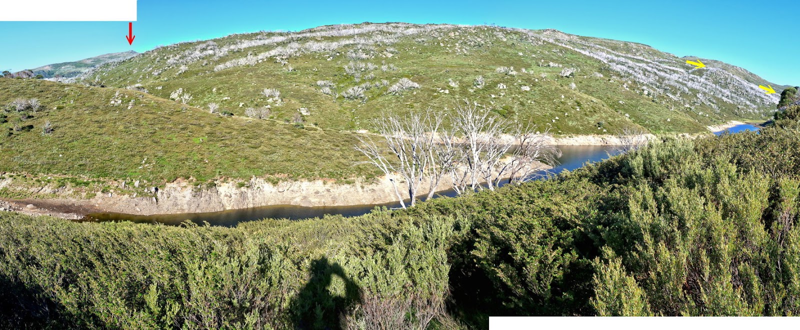
2) The direction of this pic is towards Gills Knobs & Mt Tate. We'll be able to see them once we climb up Tate East Ridge later on ... Tate East Ridge is the main mountain in this pic ... we are looking through the southern end of it.
- Just below Tate East Ridge is Guthega Pondage which stretches right across the centre of the pic.
- The lower creek on the left half of the pic is Blue Cow Creek which flows into Guthega Pondage.
- Red arrow: Little Twynam
- Yellow arrows: In the afternoon, we'll descend Tate East Ridge along there to Guthega River.
Bridge & Illawong Flying Fox over Blue Cow Creek
3) The Illawong Walk crosses Blue Cow Creek in this single-lane bridge.
- Lower right pic: I've crossed the bridge and looking back at it.

4) Illawong Flying Fox by the side of the above bridge ~~~
This flying fox is the second one over Blue Cow Creek. The first one was built by Illawong Ski Tourers in 1961 to a design by John Turner. It was replaced in 1973 using a design by Tim Lamble which followed the original concept. Upon the construction of the bridge, the flying fox was decommissioned in 2011, but not removed, because it was recognised for its heritage value. It is now on the National Trust of Australia (NSW) Register and on the NPWS Historic Places Register.

To Illawong Lodge
We've crossed Blue Cow Creek and are now walking towards Illawong Lodge.
5) Looking back at Guthega Pondage (Upper pic: Towards north. Lower pic: Towards north-north-east) ~~~
- We'll pass along its far side on its right (east side) on the return leg.
- Red circle: Intake tower ... see photo #75.

6) The Illawong Walk hugs along the southern bank of Snowy River / Guthega Pondage.
- This pic is toward west-ish.
- The 3 red arrows point to, from left to right:
1 Little Twynam
2 Mt Twynam
3 An unnamed knoll north-east of Mt Twynam

7) We are getting close to Illawong Lodge. (Click on the image to enlarge it.)
- The 6 red arrows point to, from left to right:
1 Illawong Lodge
2 Little Twynam
3 Mt Twynam
4 Mt Anton
5 Mt Anderson
6 Behind this ridge is Gills Knob.

Illawong Lodge
8) We make a short detour to check out Illawong Lodge. But it is locked.
- Yellow arrow on the right edge: After visiting Illawong Lodge, we'll go along the yellow arrow to Illawong Suspension Bridge.

To Illawong Suspension Bridge
After visiting Illawong Lodge, it is to Illawong Suspension Bridge.
9) Ken identified this flower as Alpine mint-bush, Prostanthera cuneata (refer to the Comment Section). Thanks Ken.

10) We are heading down to Illawong Suspension Bridge to cross the Snowy River.
- Red oval: The bridge
- Yellow arrow near upper right corner: After crossing the Snowy River, we'll go in that direction to Gills Knobs.
- The 3 red arrows point to, from left to right:
1 Little Twynam
2 Mt Twynam
3 Mt Anton

At Illawong Suspension Bridge over Snowy River
11) The single lane Illawong Suspension Bridge ~~~
- Upper pic: I am at the south end of the bridge ... just about to cross it.
• Left red oval: The words in the dark grey plaque are:
ILLAWONG SUSPENSION BRIDGE
Built by Illawong Ski Tourers in 1971 to a design by
Tim Lamble and with assistance from the NPWS.
The bridge is maintained by the NPWS.
This is the third bridge to have been built on,
or near, this site since 1958.
The bridge is recognised for its heritage value and
is included on the register of the National Trust
of Australia (NSW) and on the NPWS Historic
Places Register.
• Right red oval: The words in the yellow notice board are:
WARNING
Only one person at a time on
the bridge, except children
where an adult must
accompany one child at a time.
- Lower pic: I am on the bridge. (Photographed by AB)

12) These two pictures of the Snowy River are taken just before I cross the bridge.
- Upper pic: Looking up stream ... The 2 red arrows point to, from left to right:
1 Little Twynam
2 Mt Twynam
- Lower pic: Looking down stream

Pounds Creek
700 meters, 20 minutes after crossing Illawong Suspension Bridge, we arrive at Pounds Creek.
13) Crossing Pounds Creek
- Upper pic: Looking up stream
- Lower pic: Looking down stream

http://mntviews.blogspot.com.au/2016/12/tenison-woods-knoll-watsons-crags.html
Along Tate East Ridge to Gills Knobs
After crossing Pounds Creek, it is walking up and along the top of Tate East Ridge northward towards Gills Knob, our first peak for today.
14) We've climbed a bit up Tate East Ridge and now look back at where we came from:
- Small red dot: Where my car is parked at Guthega.
- Red arrow: Blue Cow Mountain ... Just in front of it and lower and in the same line of sight is Guthega Peak.
- Yellow arrows: We walked along there to Illawong Lodge.
- River in the middle of the pic: Snowy River / Guthega Pondage

15) Plenty of wild alpine flowers around

16) Wild flowers:
- Upper left: Hieracium pilosella, Mouse-ear Hawkweed ... a noxious weed that NSW National Parks & Wildlife Service would love to get rid of
- Upper right: ?
- Lower left: ?
- Lower right: An orange Billy Buttons (Craspedia)

17) Scenery on the Tate East Ridge, about half way between Illawong Suspension Bridge and Gills Knobs ~~~
- Upper pic:
• Red horizontal bar: Perisher range
• The 7 red arrows point to, from left to right:
1 Mt Perisher
2 1938-meter peak marked as Sma 0321
3 Little Stilwell
4 Mt Stilwell
5 Labelled as rocky peak #1 in my trip report to Mt Stilwell 2 weeks ago ... Click on this link:
http://mntviews.blogspot.com.au/2016/12/mt-stilwell-and-kangaroo-ridge.html
6 Little Twynam
7 Mt Twynam
• The Foxhole is behind the 1938-meter peak and can't be seen from here.
• Mt Guthrie is slightly to the left and in front of Little Stilwell. It is hard to discern its peak in this pic.
- Lower pic (continuation to the right of the upper pic):
• The 2 red arrows point to, from left to right:
1 Mt Twynam
2 Mt Aton
• Yellow arrow: We are heading there to Gills Knobs. (Gills Knobs is further behind and can't be seen from here.)

18) Compared with the previous panorama, this one is taken 38 minutes later, 725 meters further up the Tate East Rodge (also about half way between Illawong Suspension Bridge and Gills Knobs) ~~~
- Upper pic:
• Red horizontal bar: Perisher range
• The 9 red arrows point to, from left to right:
1 Mt Perisher
2 1938-meter peak marked as Sma 0321
3 The Foxhole
4 Little Stilwell
5 Mt Stilwell
6 Labelled as rocky peak #1 in my trip report to Mt Stilwell 2 weeks ago ... Click on this link:
http://mntviews.blogspot.com.au/2016/12/mt-stilwell-and-kangaroo-ridge.html
7 Little Twynam
8 Mt Twynam
9 Mt Anton
• Mt Guthrie somewhere between and in front of The Foxhole & Little Stilwell. It is hard to discern its peak in this pic.
- Lower pic (continuation to the right of the upper pic):
• Red arrow: Mt Anderson
• AB is heading in the direction of Gills Knobs. (Gills Knobs can't be seen from here.)

19) Another 6 minutes later, about 150 meters further up the Tate East Rodge, we are able to see the places we will soon be going: Gills Knobs, Mt Tate & Mann Bluff.
- Upper pic:
• Red horizontal bar: Perisher range
• The 10 red arrows point to, from left to right:
1 The Foxhole
2 Little Stilwell
3 Mt Stilwell
4 Labelled as rocky peak #1 in my trip report to Mt Stilwell 2 weeks ago ... Click on this link:
http://mntviews.blogspot.com.au/2016/12/mt-stilwell-and-kangaroo-ridge.html
5 North Rams Head
6 Rams Head
7 Little Twynam
8 Mt Twynam
9 Mt Anton
10 Watsons Crags
• Tenison Woods Knoll can't be seen from here.
• 2 1938-meter peak marked as Sma 0321 is just to the left and in front of The Foxhole. Mt Guthrie is just to the right and in front of The Foxhole. It is hard to discern both peaks in this pic.
- Lower pic (continuation to the right of the upper pic):
• The 4 red arrows point to, from left to right:
1 Mt Anderson
2 Mann Bluff south peak
3 Mt Tate ... we'll be going there after climbing over Gills Knobs.
4 Gills Knobs ... we are heading there now.

Climbing up Gills Knobs
20) Climbing up Gills Knobs ~~~
- Red arrow: Mann Bluff south peak

At Gills Knobs
21) The cairn at Gills Knobs ~~~
- This is not the highest point of Gills Knobs. The highest point is about 300 meters to the north ... see photos #26 and #27.
- The 4 red arrows point to, from left to right:
1 Mann Bluff south peak
2 Mann Bluff middle peak
3 Mann Bluff north peak
4 Mt Tate

22) Me (upper pic) and AB (lower pic) at the cairn ~~~
The 4 red arrows point to, from left to right:
1 Mann Bluff south peak
2 Mann Bluff middle peak
3 Mann Bluff north peak
4 Mt Tate

23) The 3 pics below form an almost 360-degree panorama from the cairn:
- Upper pic: Towards Guthega, where we came from early this morning:
• Small red dot: Where my car is parked ... Photo #24 zooms into it.
• Yellow circle: Guthega Pondage ... You can just make out its dam wall. On the return leg, we'll walk on the dam wall back to the car. Photo #24 zooms into it.
• The 3 red arrows point to, from left to right:
1 Blue Cow Mountain
2 Back Perisher Mountain
3 Mt Perisher
- Middle pic (continuation to the right of the upper pic): Towards where we just came from:
• Yellow arrow: We just climbed over the rocks and walked along the arrow to here.
• The 15 red arrows point to, from left to right:
1 1987-meter peak marked as Sma 0318
2 1944-meter peak marked as Sma 0322
3 Drift Hill
4 The Foxhole
5 Little Stilwell
6 Mt Stilwell
7 Labelled as rocky peak #1 in my trip report to Mt Stilwell 2 weeks ago ... Click on this link:
http://mntviews.blogspot.com.au/2016/12/mt-stilwell-and-kangaroo-ridge.html
8 North Rams Head
9 Rams Head
10 Little Twynam
11 Mt Twynam
12 Mt Anton
13 Tenison Woods Knoll
14 Watsons Crags
15 Mt Anderson
- Lower pic (continuation to the right of the middle pic): Towards where we'll be going:
• The 4 red arrows point to, from left to right:
1 Mann Bluff south peak
2 Mann Bluff middle peak
3 Mann Bluff north peak
4 Mt Tate ... We will be climbing it soon.
• Left yellow circle: Also in Gills Knobs ... The rock there is higher than here. We are going there next.
• Right yellow circle: Highest point of Gills Knobs ... we'll climb it too ... see photos #26 and #27.

24) Zooming into photo #23 at Guthega village and at where my car is parked ~~~
- Red arrow: I can just barely see my car ... the smaller car pointed to by the arrow; not the larger one.
- Yellow arrow: On the return leg, we'll walk on the dam wall back to the car.
- Red circle: The Intake tower that we saw in photo #1.

To Gills Knobs highest point
The cairn in photos #21 and #22 is not the highest point of Gills Knob. Hence before going to Mt Tate, we visit the other higher points of Gills Knobs
25) First, we go to a pile of rocks that is the 2nd highest point of Gills Knobs.
- Upper pic:
• Right red arrow: Mt Tate
• Left red arrow: We are going to this pile of rocks which is higher than the cairn.
• Note the entire Gills Knobs is covered with Leucochrysum alpinum (Alpine Sunrays).
- Lower pic: This is the pile of rocks pointed to by the red arrow in the upper pic.

26) Next, we go the highest point of Gills Knobs.
- Upper pic: The 5 red arrows point to, from left to right:
1 Mann Bluff south peak
2 Mann Bluff middle peak
3 Mann Bluff north peak
4 Mt Tate ... We will be climbing it soon.
5 The highest point of Gills Knobs ... we are going there now.
- Lower pic: Highest point of Gills Knobs

At Gills Knobs highest point
27) This is it ... We've reach the highest point of Gills Knobs, about 1952 meters.
Like the rest of the Gills Knobs area, it is covered with Leucochrysum alpinum (Alpine Sunrays).

Looking back at Gills Knobs
28) Looking back ~~~
- Upper pic: Looking back from the 2nd highest point at the pile of rocks where the cairn is (photos #21 and #22) ~~~
• The 10 red arrows point to, from left to right:
1 1987-meter peak marked as Sma 0318
2 1944-meter peak marked as Sma 0322
3 Drift Hill
4 The Foxhole
5 The pile of rocks where the cairn is (photos #21 and #22).
6 Mt Stilwell
7 Labelled as rocky peak #1 in my trip report to Mt Stilwell 2 weeks ago ... Click on this link:
http://mntviews.blogspot.com.au/2016/12/mt-stilwell-and-kangaroo-ridge.html
8 North Rams Head
9 Rams Head
10 Little Twynam
- Lower pic: Looking back from the highest point of Gills Knobs ~~~
Red circle: 2nd highest point of Gills Knobs ... We went through there not that long ago, see photo #25.

29) We've climbed down from Gills Knobs and now looking back at its highest point:
- Upper pic:
• The 6 red arrows point to, from left to right:
1 1987-meter peak marked as Sma 0318
2 1944-meter peak marked as Sma 0322
3 Gills Knobs highest point
4 Mt Stilwell
5 North Rams Head
6 Little Twynam
- Lower pic: We've moved further away Gills Knobs:
• The 4 red arrows point to, from left to right:
1 Back Perisher Mountain
2 Mt Perisher
3 Gills Knobs highest point
4 Mt Stilwell

To Mt Tate
30) This pic is towards where we are going now.
- The 4 red arrows point to, from left to right:
1 Mann Bluff south peak
2 Mann Bluff middle peak
3 Mann Bluff north peak
4 Mt Tate ... we are heading there now.
- Red oval: First of all, we'll climb over this pile of rocks.

31) Climbing the pile of rocks in the red oval of the previous pic

32) After climbing over the pile of rocks of the previous pic, there is another pile of rocks to get over (in the red oval).
- Upper pic: Mt Tate is the tall peak in the background. As you can see, once we are over the pile of rocks (red oval), it will be a clear run to the base of Mt Tate.
- Lower pic: This is the pile of rocks in the red oval of the upper pic.

33) The 3 pics below form an almost 360-degree panorama from the top of the rocks of the previous pic:
- Upper pic: Towards where we came from:
• Red oval: The rocks of photo #31
• Small red dot: Where my car is parked in Guthega village ... also see Photo #24.
• The 10 red arrows point to, from left to right:
1 Blue Cow Mountain
2 Guthega Peak
3 Back Perisher Mountain
4 Mt Perisher
5 1987-meter peak marked as Sma 0318
6 1944-meter peak marked as Sma 0322
7 Drift Hill
8 Gills Knobs
9 The Foxhole
10 Mt Stilwell
- Middle pic (continuation to the right of the upper pic):
• The 9 red arrows point to, from left to right:
1 Mt Stilwell
2 Little Twynam
3 Mt Anton (Hard to see its peak because it blends in with the slope of Mt Twynam)
4 Mt Twynam
5 Tenison Woods Knoll
6 Mt Anderson (Hard to see its peak because it blends in with the range in the background)
7 Watsons Crags
8 Mann Bluff south peak
9 Mann Bluff middle peak
- Lower pic (continuation to the right of the middle pic): Towards where we'll be going:
• The 3 red arrows point to, from left to right:
1 Mann Bluff middle peak
2 Mann Bluff north peak
3 Mt Tate ... We will be climbing it soon.

34) Mountain Celery (Aciphylla glacialis) ... a common plant in the Kosciuszko National Park

35) We are walking closer and closer to Mt Tate ~~~
- Lower right pic: The summit trig can't be seen yet. It is behind the rocks. We are going there along the yellow arrows.

36) Now we can see the trig at the summit of Mt Tate.

Mt Tate East summit
37) Mt Tate summit, 2068 meters ~~~
There are an amazing large number of black birds (Little Ravens) around the top of Mt Tate, not just here at the trig, but all around the summit.

38) Time for photoshoot :-)
- Lower pic: AB's face is wrapped up to prevent being sun burnt :-)

39) The 3 pics below form a 360-degree panorama from the summit of Mt Tate:
- Upper pic:
• Left half: Towards where we came from ... Photo #40 zooms into this area.
• Right half: Towards where we'll be going next ... Photo #41 zooms into this area.
• Small red dot: Where my car is parked in Guthega village ... also see Photo #24.
• The 16 red arrows point to, from left to right:
1 Blue Cow Mountain
2 Guthega Peak
3 Back Perisher Mountain
4 Mt Perisher
5 1987-meter peak marked as Sma 0318
6 1944-meter peak marked as Sma 0322
7 Gills Knobs
8 Drift Hill
9 Mt Stilwell
10 Little Twynam
11 Mt Anton (Hard to see its peak because it blends in with the slope of Mt Twynam)
12 Mt Twynam
13 Mt Anderson ((Hard to see its peak because it blends in with the range in the background)
14 Mt Townsend, barely poking its head above the slope of Tenison Woods Knoll
15 Tenison Woods Knoll
16 Watsons Crags
• The 2 yellow arrows ... Mann Buff ... we are going there next: (See also photo #41.)
1 Mann Bluff middle & south peaks ... they are in the same line of sight.
2 Mann Bluff north peak
- Middle pic (continuation to the right of the upper pic):
• The 2 red arrows point to, from left to right:
1 Mt Jagungal
2 Dicky Cooper Bogong
- Lower pic (continuation to the right of the middle pic): Towards where we'll be going:
• The 3 red arrows point to, from left to right:
1 Mt Jagungal
2 Dicky Cooper Bogong
3 Blue Cow Mountain
• See photo #42. It zooms into Jagungal and Dicky Cooper Bogong.
- Continuation to the right of the lower pic is the upper pic, thus completing a 360-degree panorama.

40) Zooming into the left part of the upper pic of photo #39 ~~~
- Small red dot: Where my car is parked in Guthega village ... also see Photo #24.
- Below the red dot is Guthega Pondage.
- The 8 red arrows point to, from left to right:
1 Guthega Peak
2 Back Perisher Mountain
3 Mt Perisher
4 1987-meter peak marked as Sma 0318
5 1944-meter peak marked as Sma 0322
6 Gills Knobs
7 Drift Hill
8 Mt Stilwell

41) Zooming into the right part of the upper pic of photo #39 ~~~
- The 8 red arrows point to, from left to right:
1 North Rams Head
2 Little Twynam
3 Mt Anton (Hard to see its peak because it blends in with the slope of Mt Twynam)
4 Mt Twynam
5 Mt Anderson ((Hard to see its peak because it blends in with the range in the background)
6 Mt Townsend, barely poking its head above the slope of Tenison Woods Knoll
7 Tenison Woods Knoll
8 Watsons Crags
- The 3 yellow arrows ... Mann Buff ... we are going there next:
1 Mann Bluff south peak
2 Mann Bluff middle peak
3 Mann Bluff north peak

42) Towards north and north-north-east ~~~
Zooming into Mt Jagungal, Dicky Cooper Bogong, Kerries Ridge and Gungartan ... the 4 red arrows from left to right

43) Still at Mt Tate summit ~~~
Plenty of these Christmas Beetles around the summit

Climbing down Mt Tate
44) Time to leave Mt Tate for Mann Bluff

45) Looking back at Mt Tate ~~~
- The previous pic was taken at the back of the pile of rocks to the left of the yellow arrow.
- Red arrow: Mt Tate summit
- Yellow arrow: The way we climbed down Mt Tate

46) Red arrow: Mt Tate summit

To Mann Bluff middle peak
47) The 3 red arrows point to the south/middle/north peaks of Mann Bluff. We'll climb the middle peak first.

48) Euphrasia (Eyebright) ... Could it be Euphrasia collina? Please let me know.

49) Mann Bluff ~~~
- Middle peak: Left side ... we are going there now.
- North peak: Right side

At Mann Bluff middle peak
We reach the summit of Mann Bluff's middle peak. At about 2003 meters, it is the lowest of the 3 Mann Bluff peaks.
50) The 3 pics below form a 360-degree panorama from the top of the middle peak:
- Upper pic:
• The 4 red arrows point to, from left to right:
1 Mann Bluff north peak ... We'll climb it next.
2 Mt Jagungal
3 Dicky Cooper Bogong
4 Mt Tate ... We came from there.
- Middle pic (continuation to the right of the upper pic):
• The 9 red arrows point to, from left to right:
1 Blue Cow Mountain
2 Back Perisher Mountain
3 Gills Knobs highest point ... photo #27
4 Mt Perisher
5 Gills Knobs, where the cairn is ... photos #21 and #22
6 1987-meter peak marked as Sma 0318
7 1944-meter peak marked as Sma 0322
8 Drift Hill
9 Mt Stilwell
- Lower pic (continuation to the right of the middle pic):
• The 5 red arrows point to, from left to right:
1 Mt Stilwell
2 Little Twynam
3 Mt Twynam
4 Tenison Woods Knoll, just poking its head above the rocks
5 Watsons Crags
• The pile of rocks under Mt Twynam is Mann Bluff's south peak
• Red oval: Three Rocks Creek flows in the valley there.
- Continuation to the right of the lower pic is the upper pic, thus completing a 360-degree panorama.

To Mann Bluff north peak
51) Now walking towards Mann Bluff's north peak

At Mann Bluff north peak
At about 2004 meters, the north peak is Mann Bluff's 2nd highest peak.
52) The 3 pics below form a 360-degree panorama from the top of the north peak:
- Upper pic:
• Left half: Towards where we came from ... Photo #53's upper pic zooms into this area.
• Right half: Towards where we'll be going next ... Photo #53's lower pic zooms into this area.
• The 15 red arrows point to, from left to right:
1 Blue Cow Mountain
2 Back Perisher Mountain
3 Gills Knobs highest point ... photo #27
4 The pile of rocks under this arrow is Mann Bluff's middle peak. We just came from there.
5 Mt Perisher
6 Gills Knobs, where the cairn is ... photos #21 and #22
7 1987-meter peak marked as Sma 0318
8 1944-meter peak marked as Sma 0322
9 Drift Hill
10 Mann Bluff's south peak. We'll climb it next.
11 Little Twynam
12 Mt Anton
13 Mt Twynam
14 Mt Anderson
15 Tenison Woods Knoll
- Middle pic (continuation to the right of the upper pic):
• Red arrow Watsons Crags
• Red oval: Three Rocks Creek flows in the valley there.
- Lower pic (continuation to the right of the middle pic):
• The 4 red arrows point to, from left to right:
1 Mt Jagungal
2 Dicky Cooper Bogong
3 Mt Tate
4 Blue Cow Mountain
- Continuation to the right of the lower pic is the upper pic, thus completing a 360-degree panorama.

53) Zooming into parts of the upper pic of photo #52 ~~~
- Upper pic:
• Zooming into Left side of photo #52
• The 8 red arrows point to, from left to right:
1 Blue Cow Mountain
2 Back Perisher Mountain
3 Gills Knobs highest point ... photo #27
4 Mt Perisher
5 Gills Knobs, where the cairn is ... photos #21 and #22
6 1987-meter peak marked as Sma 0318
7 1944-meter peak marked as Sma 0322
8 Drift Hill
• Red oval: The pile of rocks is Mann Bluff's middle peak. We just came from there.
- Lower pic (continuation to the right of the upper pic):
• Zooming into right side of photo #52
• The 7 red arrows point to, from left to right:
1 Drift Hill
2 Mann Bluff's south peak. We'll climb it next.
3 Little Twynam
4 Mt Anton
5 Mt Twynam
6 Mt Anderson
7 Tenison Woods Knoll

To Mann Bluff south peak
54) We've climbed down from the north peak, now heading towards the south peak.
- Left red arrow: Top of Mann Bluff's middle peak
- Right red arrow: Top of Mann Bluff's south peak ... photo #55 zooms into it.

55) Mann Bluff's south peak ... the red arrow
- Upper pic: Zooms into the right side of previous pic.

56) There is bird at the summit !
This is quite strange ... Considering there is a horde of Little Ravens at the nearby Mt Tate, but none here. Only this lone little bird.
Does anyone know the name of this bird ?

At Mann Bluff south peak
57) We are at the top of Mann Bluff's south peak. At 2005 meters, it is also Mann Bluff's highest peak.

58) The 3 pics below form a 360-degree panorama from the top of the south peak:
- Upper pic:
• The 7 red arrows point to, from left to right:
1 Mt Stilwell
2 Little Twynam
3 Mt Anton
4 Mt Twynam
5 Mt Anderson
6 Tenison Woods Knoll
7 Watsons Crags
- Middle pic (continuation to the right of the upper pic): Photo #59 zooms into the main part of this pic.
• The 3 red arrows point to, from left to right:
1 Mt Jagungal
2 Dicky Cooper Bogong
3 Mt Tate
• Left red oval: Mann Bluff north peak
• Right red oval: Mann Bluff middle peak
- Lower pic (continuation to the right of the middle pic):
• The 10 red arrows point to, from left to right:
1 Blue Cow Mountain
2 Gills Knobs highest point ... photo #27
3 Back Perisher Mountain
4 Gills Knobs, where the cairn is... photos #21 and #22
5 Mt Perisher
6 1987-meter peak marked as Sma 0318
7 1944-meter peak marked as Sma 0322
8 Drift Hill
9 The pile of rock under the arrow is an unnamed peak south of Mann Bluff.
10 Mt Stilwell
- Continuation to the right of the lower pic is the upper pic, thus completing a 360-degree panorama.

59) Still at the summit of Mann Bluff's south peak and zooming into the middle pic of photo #58 ~~~
-The 3 red arrows point to, from left to right:
1 Mt Jagungal
2 Dicky Cooper Bogong
3 Mt Tate
- Left red oval: Mann Bluff north peak
- Right red oval: Mann Bluff middle peak

Climb down Mann Bluff south peak and to Guthega River
This morning, we came to here via the south-western tip of Guthega Pondage. Now the return leg to the car is via Guthega River and the dam wall of Guthega Pondage.
60) First, we climb down Mann Bluff's south peak ... the 2 pics below is looking back at it.

61) A panorama of Mann Bluff's north peak, middle peak and Mt Tate ... the 3 red arrows.

62) A little further away from Mann Bluff (Click on the image to enlarge it.) ~~~
The 5 red arrow point to from left to right:
- Mt Twynam (on the left edge)
- Mann Bluff south peak
- Mann Bluff north peak
- Mann Bluff middle peak
- Mt Tate

63) We've moved further away from Mann Bluff (walking in the south-east direction).
- Upper pic:
• The 8 red arrows point to, from left to right:
1 Back Perisher Mountain
2 Gills Knobs highest point ... photo #27
3 Mt Perisher
4 Gills Knobs, where the cairn is... photos #21 and #22
5 1987-meter peak marked as Sma 0318
6 1944-meter peak marked as Sma 0322
7 Drift Hill
8 Mt Stilwell
- Lower pic (continuation to the right of the upper pic):
• The 8 red arrows point to, from left to right:
1 Little Twynam
2 Mt Anton
3 Mt Twynam
4 Tenison Woods Knoll
5 Mt Anderson
6 Mann Bluff south peak ... we just came from there
7 Mann Bluff middle peak
8 Mann Bluff north peak
• Watsons Crags can't be seen from here. It is behind the unnamed rocky peak in the middle of the pic.
- At where we are now, we can't see Mt Tate ... blocked by a minor unnamed ridge running down south-south-west from Mt Tate ... but see next pic.

64) We are near the top, but still on the west side of Tate East Ridge which runs down south from Mt Tate.
- Upper pic:
• The 7 red arrows point to, from left to right:
1 Mt Stilwell
2 Little Twynam
3 Mt Anton
4 Mt Twynam
5 Tenison Woods Knoll
6 Mt Anderson
7 Mann Bluff south peak
• Watsons Crags can't be seen here ... blocked by Mt Anderson.
- Lower pic (continuation to the right of the upper pic), looking back at where we have been:
• The 4 red arrows point to, from left to right:
1 Mann Bluff south peak
2 Mann Bluff middle peak
3 Mann Bluff north peak
4 Mt Tate

65) AB finds a dead Funnel-web spider. But why haven't the birds get to it first?

66) Compared to photo #64, we are now on the east side of Tate East Ridge. The scenery here is very different because we are now facing east.
- Upper pic:
• Red arrows: Blue Cow Mountain
• Horizontal red oval: Guthega River flows in the valley there. We are going to the river as pointed by AB.
- Lower pic: A bit further down the slope, and facing where we'll be going:
• The 5 red arrows point to, from left to right:
1 Blue Cow Mountain
2 Guthega Peak
3 Back Perisher Mountain
4 Mt Perisher
5 1987-meter peak marked as Sma 0318
• Horizontal red oval: Guthega River flows in the valley there.
• Small red dot: Where my car is parked in Guthega village
• Below the small red dot is Guthega Pondage.
- We'll climb down to Guthega River, follow the course of the river to Guthega Podage, cross its dam wall, then back to the car.

67) Zooming into the dead Snow Gums of the previous pic ~~~
They were the result of a big bush fire many years ago.

68) Going down to Guthega River ~~~
It gets quite scrubby the closer we are to the river.

69) AB finds this skull. Wonder what animal is it?

Guthega River
70) This is where we reach Guthega River. From now on, we follow the course of the river to Guthega Pondage.
- Upper pic: Looking up stream, towards north
• Red arrow: Could it be 1950-meter peak marked as Sma 0692 ?
- Lower pic: Looking down stream, towards south
• Red arrow: Mt Perisher

71) We are following course of Guthega River to Guthega Pondage.
- Upper pic: Looking up stream, towards north
• Red arrow: Could it be 1950-meter peak marked as Sma 0692 ?
- Lower pic: Looking down stream, towards south
• Red arrow: Mt Perisher

72) Occasionally we rock-hop along the Guthega River as the vegetation can be dense on the banks of the river.
- Upper pic: Looking up stream
- Lower pic: Looking down stream

Guthega Pondage
73) Arriving at Guthega Pondage ~~~
Red arrow: 1987-meter peak marked as Sma 0318

74) Guthega Pondage
- Upper pic: The sandy bank in the red square is enlarged in the lower pics.
- Lower pics: Note the striated sand bank ... interesting !

75) Passing the intake tower ~~~
- Red arrow: 1987-meter peak marked as Sma 0318

76) Crossing the dam wall

77) Guthega Pondage, taken from the dam wall ~~~
- Red arrow: 1987-meter peak marked as Sma 0318
- Yellow arrow: We were walking along there to Illawong Lodge this morning.
- Left red oval: Blue Cow Creek flows into this inlet.
- Right red oval: Snowy River flows into this inlet.

78) Spillway of Guthega Pondage

79) A nice view of Guthega Pondage and its dam wall
- Tate East Ridge is on the left side of the pic.
- Red circle: Intake tower ... see photo #75.
- Yellow arrows: Not that long ago, we descended Tate East Ridge along there to Guthega River.

Guthega Village
80) Guthega Village
- Red dot: Where my car is parked
- Yellow arrows: The way to the car

Well, this is the end of the trip report to Gills Knobs, Mt Tate and Mann Bluff.
Weird rolling clouds over Michelago
On the drive back to Sydney ...
81) (Click on the image to enlarge it.)
This photograph is the Tinderry Mountain Range taken at 7:37pm near the small town of Michelago while on my way home to Sydney. Specifically, it is taken on Monaro Highway, 1 km south of the turn off to Ryrie Street (into Michelago), and looking towards the east.
The white stuff covering the mountain range is not snow. They are clouds. But notice it is clear blue sky everywhere !
Is there a meteorologist, budding meteorologist, pretend meteorologist out there who can explain this phenomenon?
(I think it is called orographic cloud / fog.)

Post script - Other A2K climbing trips
• 2017 November
Rank Name Elev Grid Ref
20 Mt Jagungal 2062 m 248 987
27 Toolong Range 2025 m 258 988
Trip report will be written up soon ... whatever that means :-)
In the mean time, if you like to know the details, contact me.
• 2017 January with AB
Rank Name Elev Grid Ref
18 Mt Tate 2068 m 214 760
32 Mann Bluff 2005 m 208 754
This trip report :-)
• 2016 December with AB
Rank Name Elev Grid Ref Comment
3 Mt Twynam 2196 m 179 716
11 Tenison Woods Knoll 2136 m 166 719 Watsons Crag Dome or Mt Dubious
28 Watsons Crags 2021 m 161 733
30 Mt Anton 2010 m 191 727
Photos and trip report are in my blog:
http://mntviews.blogspot.com.au/2016/12/tenison-woods-knoll-watsons-crags.html
• 2016 December with AB & DN
Rank Name Elev Grid Ref Comment
17 Kangaroo Ridge 2077 m 182 644 Morning
21 Mt Perisher 2054 m 243 697 Afternoon
22 Mt Stilwell 2054 m 187 659 Morning
25 Little Stilwell 2030 m 190 657 Morning
29 Back Perisher Mtn 2014 m 247 708 Afternoon
31 The Foxhole 2010 m 198 661 Morning
Photos and trip reports are in my blog:
- Morning: http://mntviews.blogspot.com.au/2016/12/mt-stilwell-and-kangaroo-ridge.html
- Afternoon: http://mntviews.blogspot.com.au/2016/12/mt-perisher-back-perisher-mtn.html
• 2015 October with RZ
Rank Name Elev Grid Ref
33 Dicky Cooper Bogong 2003 m 232 832
Photos and trip report are in my blog:
http://mntviews.blogspot.com.au/2015/10/dicky-cooper-bogong-granite-peaks-nsw.html
• 2015 March with AB, DN & Saf
Rank Name Elev Grid Ref
19 Gungartan 2068 m 258 835
24 Kerries Ridge 2050 m 262 851
Photos and trip report are in my blog:
http://mntviews.blogspot.com.au/2015/03/gungartan-kerries-ridge-nsw-australia.html
• 2014 December with AB & DN
Rank Name Elev Grid Ref Comment
1 Mt Kosciuszko 2228 m 132 647
2 Mt Townsend 2209 m 128 684 Abbott Range
7 Alice Rawson Peak 2167 m 132 692 Abbott Range
8 Byatts Camp 2159 m 118 676 Abbott Range
9 Abbott Peak 2145 m 122 678 Abbott Range
10 Carruthers Peak 2145 m 157 698
12 Mt Northcote 2131 m 146 676
wrong Byatts Camp 2110 m 116 671 Abbott Range
15 Mt Clarke 2110 m 154 672
16 Mt Lee 2105 m 152 688
Photos and trip report are in my blog:
http://mntviews.blogspot.com.au/2014/12/lee-northcote-clarke-abbott-range.html
• 2014 November with AB & DN
Rank Name Elev Grid Ref
1 Mt Kosciuszko 2228 m 132 647
4 Rams Head 2193 m 128 608
5 Etheridge Ridge 2180 m 140 644
6 Rams Head North 2177 m 137 618
23 South Rams Head 2052 m 116 588
Photos and trip report are in my blog:
http://mntviews.blogspot.com.au/2014/11/etheridge-ridge-kosciuszko-rams-head.html
• 2014 April with DH
Rank Name Elev Grid Ref
1 Mt Kosciuszko 2228 m 132 647
2 Mt Townsend 2209 m 128 684
3 Mt Twynam 2196 m 179 716
10 Carruthers Peak 2145 m 157 698
13 Little Twynam 2130 m 185 711
and incidentally bagging 3 highest peaks of Australia in one day. Photos and trip report are in my blog:
http://mntviews.blogspot.com.au/2014/04/kosciuszko-townsend-twynam-carruthers.html
• 2011 April with RE
Rank Name Elev Grid Ref
1 Mt Kosciuszko 2228 m 132 647
2 Mt Townsend 2209 m 128 684
14 Muellers Peak 2125 m 138 673
Photos and trip report are in my blog:
http://mntviews.blogspot.com.au/2011/04/kosciuszo-muellers-peak-townsend-nsw.html
Looked like a great day of walking. The unidentified white flower is Alpine Mint Bush (Prostanthera cuneata)
ReplyDeleteThanks Ken, I have updated the report accordingly.
Delete