2017 November: Day trip to climb Mt Gudgenby from Yankee Hat Carpark, ACT, Australia
Prolog - List of named peaks in ACT above 1700 meters
I have compiled a list of named peaks in ACT above 1700 meters. There are 13 of them. And I am in the process of climbing them all.
I still have Mt Murray and Mt Scabby to tick off. Contact me if you wish to join in to climb these two ... hhmmm ... or any other mountains.
• 01 1913 m Bimberi Peak - Photos and trip reports are in my blogs:
- From east: 2011-01 http://mntviews.blogspot.com.au/2011/01/bimberi-act-australia-east-approach.html
- From west: 2009-12 http://mntviews.blogspot.com/2009/12/bimberi-act-australia.html
2018-12 https://mntviews.blogspot.com/2018/12/bimberi-peak-and-mt-murray-act-australia.html
(including climbing Mt Murray)
• 02 1855 m Mt Gingera - Photos and trip report are in my blog:
http://mntviews.blogspot.com.au/2013/01/mt-gingera-mt-ginini-act-australia.html
• 03 1845 m Mt Murray - Photos and trip report are in my blog:
http://mntviews.blogspot.com/2018/12/bimberi-peak-and-mt-murray-act-australia.html
• 04 1829 m Mt Kelly - Photos and trip report are in my blog:
http://mntviews.blogspot.com.au/2015/01/kelly-burbidge-nsw-australia.html
• 05 1798 m Mt Scabby - Grid Ref 676 411
1805 m Unnamed peak just east of Mt Scabby - Grid Ref 681 410
Trip report is under construction.
• 06 1791 m Mt Namadgi - Photos and trip report are in my blog:
http://mntviews.blogspot.com.au/2015/10/mt-namadgi-act-australia.html
• 07 1766 m Ginger Ale - Grid Ref 601 586 (between Rolling Ground Gap & Blackfellows Gap)
Photos and trip report are in my blog:
http://mntviews.blogspot.com.au/2015/02/little-ginini-ginger-ale-act-australia.html
• 08 1762 m Mt Ginini - Photos and trip report are in my blog:
http://mntviews.blogspot.com.au/2013/01/mt-gingera-mt-ginini-act-australia.html
• 09 1739 m Mt Gudgenby - This trip report
• 10 1738 m Little Ginini - Photos and trip report are in my blog:
http://mntviews.blogspot.com.au/2015/02/little-ginini-ginger-ale-act-australia.html
• 11 1727 m Sentry Box Mountain eastern peak - Grid Ref 721 338
1696 m Sentry Box Mountain western peak - Grid Ref 714 338
1673 m Sentry Box Rock - Grid Ref 713 346
Photos and trip report are in my blog:
http://mntviews.blogspot.com.au/2015/11/sentry-box-act-australia.html
• 12 1724 m Mt Burbidge - Photos and trip report are in my blog:
http://mntviews.blogspot.com.au/2015/01/kelly-burbidge-nsw-australia.html
• 13 1711 m Mt Mavis - Grid Ref 722 493 (just north-east of Mt Namadgi; east of Big Creamy Flats)
Photos and trip report are in my blog:
http://mntviews.blogspot.com.au/2017/12/mt-mavis-act-australia.html
Data source:
- First, from LPI maps from Department of Lands
- Then from 1:50,000 scaled Rooftop's map called "Namadgi - ACT South Activities Map" 2011 edition
- Finally, in Google we trust :-)
Today's climb - Mt Gudgenby
Continuing my effort to climb all the 13 over 1700-meter peaks in ACT ...
Today's climb, with DH, is to Mt Gudgenby, 1739 meters. In my list above, it is the 9th highest named peak in ACT.
As is the case with most 1700-meter plus peaks in ACT, the view from the summit is excellent. But to get there is not so simple ... fair amount of scrub bashing is required. The scrub is not as thick as to Mt Kelly and Mt Namadgi. But still, it is thick enough to make you want to cry :-)
It took DH and I 11 hours for the return trip. We are slow. Fast climbers can complete it in 7 hours.
Postscript
5.5 years later, in 2023-April, a group of us will climb Mt Gudgenby again.
Some interesting pictures are in this link:
https://drive.google.com/file/d/1NzZm8SG3EK7F09kZf6QdGejcfHlnKCao/view?usp=share_link
Maps
• 8626-2N Yaouk 1:25,000
• Rooftop's "Namadgi - ACT South Activities Map" 2011 edition; 1:50,000
• 8626 Tantangara 1:100,000
The relevant part of the 1:25,000 scaled map can be downloaded from:
https://drive.google.com/file/d/1vYIkuv-HrCyJnqXaZ5bLKf89R8BciqxI/view?usp=sharing
The same relevant part of the 1:25,000 scaled map is reproduced below as 2 images:

This one is continuation to the right of previous map.

Yankee Hat Carpark
The starting point of the Mt Gudgenby climb is at Yankee Hat Carpark on Old Boboyan Rd.
If you are coming from the direction of Canberra, drive south on Boboyan Rd. At about 0.7 km pass the bridge crossing Rendezvous Creek, or 0.3 km pass the bridge crossing Gudgenby River, watch out on your right for a fork with a very small sign pointing to Yankee Hat Carpark & Old Boboyan Rd. You really need to watch out for it, as one blink and you'll miss it.
GPS tracklog file & route
The GPX tracklog file of our walk can be downloaded from:
- From Yankee Hat Carpark to Mt Gudgenby:
https://drive.google.com/file/d/1n_zz9xaJVv_lGyOkFtZaMAi0cRLAjYJe/view?usp=sharing
- From Mt Gudgenby back to Yankee Hat Carpark:
https://drive.google.com/file/d/11q-DKHxF5CJm4GU8UQoz5Gv8w-4m3ntL/view?usp=sharing
Satellite overview of our route in red:
- Upper Red arrow: Summit of Yankee Hat
- Lower red arrow: Summit of unnamed 1558-meter peak
- Left end of the route: Summit of Mt Gudgenby
- Right end of the route: Yankee Hat Carpark

The 1:25,000 scaled map with our tracklog superimposed on it can be downloaded from:
https://drive.google.com/file/d/1jtWI-_Ya0wUN3sioAtMnFOK9EAVUw2HE/view?usp=sharing
The same map with our tracklog in red is reproduced in the 2 images below:
- Lower left blue arrow: A pile of boulders to the north of Mt Gudgenby summit
- Upper right blue arrow: Unnamed 1558-meter peak

Continuation to the right of the previous map:
- Lower left blue arrow: Where we leave the forest road and go off-track bushbashing to Mt Gudgenby
- Upper right blue arrow: Yankee Hat Carpark

In summary, our route is:
- Start at Yankee Hat Carpark.
- Walk on Old Boboyan Rd.
- After 1.4 km, turn west into a forest road.
- After another 2.25 km, go off-track to climb Mt Gudgenby.
- After climbing Mt Gudgenby, explore a pile of boulder nearby (just north of the summit).
- Retrace our steps back to Yankee Hat Carpark.
Timeline & Distance
05:53 0.0 km Start at Yankee Hat Carpark
06:11 1.4 km Leave Old Boboyan Rd by turning right (west) into a forest road
06:43 3.65km At where we'll leave the forest road
06:47 3.7 km Start to leave the forest road ... to go off-track toward Mt Gudgenby
07:46 5.6 km Stop for rest
Rest
07:55 5.65km Resume walking
08:43 6.6 km Stop for morning tea
Morning tea
08:59 6.8 km Resume walking
09:50 7.55km Stop for rest
Rest
09:54 7.6 km Resume walking
11:21 8.7 km Arrive at Mt Gudgenby summit
Lunch
11:58 8.75km Leave summit
12:14 9.0 km Start to veer off towards a pile of nearby boulders just north of the summit
12:19 9.1 km At where the pile of boulders is too difficult for me to climb
12:21 9.1 km Start to retrace my steps
12:26 9.2 km Back at the same spot as at 12:14; and start to climb down Mt Gudgenby
14:02 10.4 km Stop for rest
Rest
14:11 10.5 km Resume walking
16:02 13.4 km Meet up with forest road; same spot as at 06:43
Rest
16:08 13.45km Start walking
16:46 15.75km At junction of the forest road and Old Boboyan Rd; same spot as 06:11
17:07 17.2 km Back at Yankee Hat Carpark
==============================================
Total: 11 hrs 14 mins at leisurely pace
17.2 km Distance is from Google Earth
20.3 km Distance is from Garmin GPS
Pictures - Yankee Hat Carpark
1) Yankee Hat Carpark by the side of Old Boboyan Rd ~~~
This is where we park our car and start our walk. (Actually it is DH's car, first from the right.)
Unbeknownst to us, DH is standing on a bull ant mound, the red oval. Not long afterwards, he is bitten all over and has to strip naked to get rid of the ants crawling all over his body, inside the clothes !
An advice to anyone reading this blog post ... do not park your car near that spot !

2) View from Yankee Hat Carpark ~~~
(Click on the image to enlarge it.)
- Time now is 5:34am, just before sunrise at 5:45am.
- The 3 red arrows point to, from left to right:
1 Yankee Hat
2 Mt Burbidge, toward north-west
3 Mt Namadgi
- Mt Kelly is just blocked by the slope on the right side of Yankee Hat.
- Middle Creek flows in the valley to the right of Yankee Hat.

3) Same scene as above, 15 minutes later ... and note the colour difference due to sunrise ~~~
(Click on the image to enlarge it.)
- Time now is 5:49am, just after sunrise at 5:45am.
- The 3 red arrows point to, from left to right:
1 Yankee Hat
2 Mt Burbidge, toward north-west
3 Mt Namadgi
- Mt Kelly is just blocked by the slope on the right side of Yankee Hat.
- Middle Creek flows in the valley to the right of Yankee Hat.

I climbed Mt Kelly and Mt Burbidge in January 2015. Photos and trip report are in:
http://mntviews.blogspot.com.au/2015/01/kelly-burbidge-nsw-australia.html
And climbed Mt Namadgi in October 2015. Photos and trip report are in:
http://mntviews.blogspot.com.au/2015/10/mt-namadgi-act-australia.html
Old Boboyan Road
4) Yankee Hat Carpark is just by the side of this locked gate.
Initially, we'll be walking on Old Boboyan Road, in the direction of the yellow arrow, to Mt Gudgenby.

5) Walking along Old Boboyan Road

Forest road to Mt Gudgenby
6) We are now at the junction of Old Boboyan Road and a forest road ~~~
- Yellow arrow: We've just turned right (west) into the forest road; and are going to walk along the direction of the arrow.
- Yellow dots: Later on, our route to Mt Gudgenby is along the yellow dots.
- The 3 red arrows point to, from left to right:
1 Mt Gudgenby
2 Part of Mt Gudgenby (It is lower than the main peak on its left even though it looks higher in the photo.)
3 Yankee Hat

7) We are on the forest road towards Mt Gudgenby ~~~
The 2 pics below form a 180-degree panorama:
- Upper pic:
• Red arrow: Mt Gudgenby
• Yellow arrows: The forest road we are going to walk on.
• Yellow dots: Bushbashing route up the Mt Gudgenby slope.
- Lower pic: (Continuation to the right of the upper pic) Looking backwards
• Red arrow: Yankee Hat
• The large mountain to the left of Yankee Hat is unnamed. The highest peak there is 1558 meters.
• Yellow arrow: We walked along the forest road to here.

8) Plenty of kangaroos around ~~~
The one on the left has a joey with its head and tail sticking out of its mother's pouch.

9) Looking back at tussock grass glowing in morning sun ~~~
- Yankee Hat Carpark can't be seen from here. But the red arrow points to where it should be, well behind the trees.
- This area used to be a farmland. It is now part of Namadgi National Park.

Bushbash up Mt Gudgenby slope
Soon after the previous pic was taken, we go off track and bushbash up the slope of Mt Gudgenby.
10) There are some creek crossings. DH is crossing one of them now.
All the creeks are easy to cross. You won't get your boots wet.

11) Bushbashing through the scrub ~~~
In many areas, the scrub is much denser than here. Not as dense as to Mt Kelly and Mt Namadgi, but still, it is thick enough to make you want to cry.

12) Occasionally, there are lone burnt out trees trunks. This one stands out because of the large hole right through its base.

13) Occasionally, we come to a rock slab. That is a godsend as then we have a few meters of clear path without bashing through the annoying scrubs.

14) Another rock slab

15) From one of the rock slabs, we can see the country below:
- Red arrow: Yankee Hat Carpark
- Yellow arrows: Roughly the way we climbed up to here.

16) An interesting chockstone

17) We are quite close to the top of Mt Gudgenby. Here we encounter tangled messes of tree trunks.
- The summit is behind the rocks in the background.
- In the 4 pics below, the two right side pics are the continuation to the right of the left side pics.

Near the summit of Mt Gudgenby
18) 5 hours after we started walking, we can see the summit of Mt Gudgenby ... refer to the lower pic.

19) Looking back down the slope ~~~
- Red dot: Yankee Hat Carpark
- The big boulder on the right side of the pic is the same big boulder as in the previous pic.
- Some white streaks in the pic are due to rain drops. There is a short light shower right now. It lasts for a few minutes only.

20) Closer to Mt Gudgenby summit

Finding a way to climb to the summit of Mt Gudgenby
We soon discover the boulders just beneath the summit are too large and steep for us to climb over. So we turn right to go around the base of the summit to find a way up.
As it turn out, we almost circumnavigate the entire summit. If we turn left here, the way to scramble up the rocks is just nearby :-)
21) While circumnavigating base of the summit, we pass by these boulders which form a nice shelter from rain and wind.

22) It is not so easy to circumnavigate the base of the summit. Most of the time, we are either scrambling over boulders or hopping over the top of them. Once we need to crawl through this hole.

23) Of the 2 pics below:
- Upper pic: At last, we climb up some boulders and find ourselves here.
- Lower pic: It looks like a promising way to proceed to the summit ... by climbing up the dead tree trunk, as DH has done here.

24) I am now at where DH was in the previous pic and looking up.
- Red circle: This is the top of the dead tree trunk in the previous pic.
- Yellow arrow: Climb up along the gap there and we'll be at the summit.

Mt Gudgenby summit - 1739 meters
Once we climb to the top of the gap of the previous pic, we are at the summit of Mt Gudgenby.
25) It took us 30 minutes from photo #20 to here at the summit, an indication that the boulder scrambling/hopping around the base of the summit wasn't all that easy. If at photo #20, had we turn left instead, maybe it would only take a few minutes to reach here.

26) Photo session - to prove we are here :-)
- Upper pic: Me ... Don't you like my hair style !?! :-)
- Lower pic: DH
Showers are at the background but not here at the summit.

27) Typical low lying plant at the summit of Mt Gudgenby.
Any one know the name of this plant?

Panorama from Mt Gudgenby summit
The next 3 photos (#28 to #30) form a 360-degree panorama.
28) Weather forecast is for showers at 3pm. However the rain came early as it is only 12pm. We can see showers very close by, to the north and east, but not here at the summit ... How lucky can one be !?!
This view from Mt Gudgenby summit is towards east ~~~
- Small red dot: Yankee Hat Carpark
- Yellow arrows: Our route to Mt Gudgenby ... approximately
- 2 red arrows from left to right: Tinderry Twin & Tinderry Peak

29) Continuation to the right of the previous pic (Click on the image to enlarge it.)
- Photo #31 zooms into the middle part of this pic.
- The 4 red arrows point to, from left to right:
1 Sentry Box eastern peak
2 Sentry Box western peak
3 Sentry Box Rock
4 Yaouk Peak
- Red oval: Nalyappa Homestead (see also photo #31) ... 2 and a half years ago, in 2015-05, I climbed Yaouk Peak from there.

30) Continuation to the right of the previous pic (Click on the image to enlarge it.)
- Photo #32 zooms into the left half of this pic.
- The 13 red arrows point to, from left to right:
1 Mt Scabby 1805-meter east peak
2 Mt Murray
3 Bimberi Peak
4 Ginger Ale
5 Mt Gingera ... Refer to photo #32 and #33 for a better view of it.
6 Mt Kelly, north-north-west-ish
7 Mt Namadgi
8 Mt Burbidge (in front of Mt Namadgi)
9 Mt Mavis
10 Mt Tennet (You can barely see it. It is far away, obscured by showers.)
11 Unnamed 1558-meter peak north-east-ish of Mt Gudgenby
12 Tinderry Twin
13 Tinderry Peak
- Continuation to the right of this pic is photo #28, thus forming a 360-degree panorama.

31) Zooming into the middle part of photo #29 ~~~
The 5 red arrows point to, from left to right:
1 Sentry Box eastern peak
2 Sentry Box western peak
3 Sentry Box Rock
4 Yaouk Peak
5 Nalyappa Homestead ... 2 and a half years ago, in 2015-05, I climbed Yaouk Peak from there.

32) Zooming into left half of photo #30 ~~~
- Red circle: A pile of boulders nearby (north-ish) ... See photos #33 and #34.
- The 9 red arrows point to, from left to right:
1 Mt Scabby 1805-meter east peak
2 Mt Murray
3 Bimberi Peak
4 Ginger Ale
5 Mt Gingera ... It pokes its top just barely out of the hill in front of it.
6 Mt Kelly, north-north-west-ish
7 Mt Namadgi
8 Mt Burbidge (in front of Mt Namadgi)
9 Mt Mavis
- The peak in front of Mt Kelly and the peak between Mt Kelly & Mt Namadgi are unnamed peaks along Scabby Range.

Explore the pile of boulders nearby
We have lunch at the summit. Then it is to climb down; and visit the pile of boulders (red circle in the previous pic).
33) The pile of boulders nearby
- The 6 red arrows point to, from left to right:
1 Ginger Ale
2 Mt Gingera ... Its top just barely poking out of the hill in front of it.
3 Mt Kelly, north-north-west-ish
4 Mt Namadgi
5 Mt Burbidge (in front of Mt Namadgi)
6 Mt Mavis
- The peak in front of Mt Kelly and the peak between Mt Kelly & Mt Namadgi are unnamed peaks along Scabby Range.

34) I explore the left side of the pile of boulders to check whether it is possible to climb up.
DH stayed behind and didn't go with me ... He is probably a bit tired.
- Red circles in both pics below: They are of the same rock.

35) Approaching the left side of the boulders of the previous pic ~~~
The 3 tall boulders here can be seen clearly in the previous pic too.

36) Going further along to the left side of the previous pic, I come to this gap.
(Both pics below are of the same gap.)
I'll climb up the gap, the top of which is as far as I'll go. From there, I see no way of climbing further up the boulders ... too steep for me :-(

37) I have climbed down the pile boulders; and taking a final look at it ... it is pretty handsome looking !!!

I didn't explore the right side the boulders. DH has an eye condition which makes him difficult to see at night. And he forgot to bring a pair of corrective glasses which would assist him in this aspect. As he is the driver, he would like to climb down the mountain earlier to minimize the amount of night-time driving. And so, after reaching the top of the gap in photo #36, it is time to climb down Mt Gudgenby.
If you have found a way to reach the top of the boulders (photos #34 / #37), please let me know. I wouldn't mind visiting Mt Gudgenby again to climb it.
PS: Nick Anderson informed me that in https://www.subw.org.au/2016/04/01/mt-gudgenby/ there is a photo of a guy at the top of these rocks. Ah well, I need to make a trip to there again.
Climbing down Mt Gudgenby
38) Taking a final look at the summit of Mt Gudgenby ~~~
We climbed up to the summit from behind the back of these boulders.

39) DH bushbashing down the slope of Mt Gudgenby ~~~
In many areas, the scrub is much denser than here.

40) If you know the name of this small caterpillar, please let me know.

On our way to the car
41) We've finished climbing down the slope of Mt Gudgenby. We've also finished all the bushbashing and off-track walking and is just back on a forest road; and taking a rest.
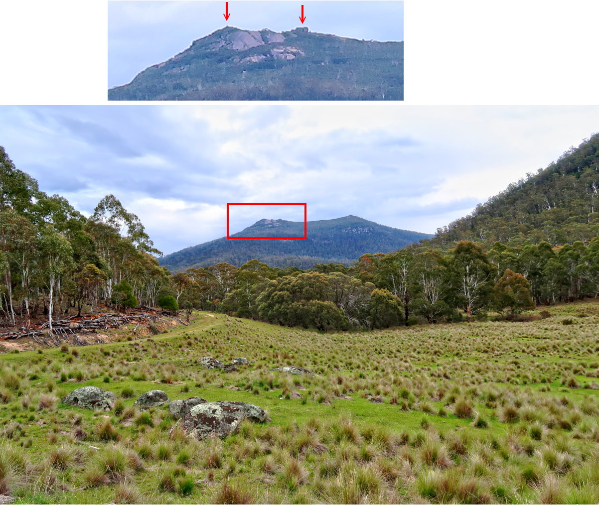
While having a rest, I take this photograph of Mt Gudgenby.
- Left red arrow: The summit
- Right red arrow: The pile of boulders I tried to climb ... Refer to photos #34 / #37.
42) Scenery further along the forest road back to the car ~~~
- The 4 red arrow point to, from left to right:
1 Mt Gudgenby
2 Unnamed 1558-meter peak
3 Yankee Hat
4 Yankee Hat Carpark is somewhere behind the trees and can't be seen from here.
- Bogong Creek flows somewhere along the vast green valley stretching from left to right. (Bogong Creek will eventually join up with Middle Creek to form Gudgenby River.)

43) Some more kangaroos

44) Tree stumps dotted the landscape ... a reminder that this area used to be a farmland. It is now part of Namadgi National Park.
- The pyramid-shaped mountain in the background is Yankee Hat.

45) We are on Old Boboyan Rd now, not far from Yankee Hat Carpark ~~~
The 3 red arrows point to, from left to right:
1 Yankee Hat
2 Mt Namadgi
3 Mt Mavis

46) Locked gate on Old Boboyan Rd ~~~
- Yankee Hat Carpark is on the left side of the road, immediately after the locked gate.
- Red oval: View to DH's car is blocked by the tree trunk there.
- The black car to the right of the red oval is the same black car in photo #1.

Postscript
5.5 years later, in 2023-April, a group of us will climb Mt Gudgenby again.
Some interesting pictures are in this link:
https://drive.google.com/file/d/1NzZm8SG3EK7F09kZf6QdGejcfHlnKCao/view?usp=share_link
Plant Names:
ReplyDeleteThe low-lying plant is Alpine wattle, Acacia Alpina, it is a rare alpine species I also encoutered on my trip up Gudgenby.
It's funny reading this as one year my dad and I camped in that sheltered hole in the rocks you pointed out so we could watch the next mornings sunrise. Brought back good memories! So ta for that
ReplyDelete