2018 November: Day-trip
Mt Marsden
Kandos State Forest, NSW, Australia
Prolog - Mt Marsden
Near the town of Kandos, NSW,
if you drive south along Glen Alice Road,
this is what you'll see:
- Red arrow: Mt Marsden summit
- Yellow arrows: The way to climb Mt Marsden
- Yellow line: Glen Alice Road
- Yellow dot: Car can be parked here by the side of
Glen Alice Road.

Mount Marsden is about 1030 meters,
an imposing hill overlooking Capertee valley.
The summit, lying at the southern end
of a ridge running north-south,
is mostly surrounded by unscalable high cliffs.
But one can climb it from about 2km
north of the summit:
- From the side of Glen Alice Road
- Climb straight up to the ridge
- Then walk along the top to the summit.
The summit itself is quite flat with no view.
But the nearby cliff edges have marvellous views
down to the farmland below.
More interesting are the pagodas
to the east of the summit,
photos #32 to #47.
If you intend to climb Mt Marsden,
make an effort to climb these pagodas too.
This trip
Just 2 of us, YM and I.
The driving time is not short ...
About 3 hours drive from Sydney.
Add in toilet stop and coffee stop,
it can be 3.5 hours.
Weather
Weather forecast is for a cloudy day.
I almost can't be bothered to go.
I don't like cloudy days
when climbing up mountains.
But it turns out to be quite a sunny day.
Any clouds around are thin high white clouds
which one would not consider as cloudy.
It is one of those occasions when
the weather forecast is pleasantly wrong.
Maps
- 1:25,000 scaled Bogee 8932-3S
- 1:100,000 scaled Mount Pomany 8932
Below is the relevant part of the
1:25,000 scaled map.
- Red line running vertically along left edge:
Glen Alice Road

GPS tracklog file & Route
The GPX tracklog file of our walk
can be downloaded from:
https://drive.google.com/open?id=1vxj2gsQ_FT0YolNZaCLgltayFTq1SbcT
Below is our tracklog in red superimposed
on the 1:25,000 map.
- Thicker red line running vertically along left edge:
Glen Alice Road
- 7 brown arrows, anti-clockwise from the top:
1 Where my car is parked, GR 232 543,
by the side of Glen Alice Road
2 Lookout 1, GR 237 540
3 Lookout 2, GR 239 535
4 Lookout 7
boundary of GR 240 525 / 240 526
no photograph in this trip report
5 Lookout 4, GR 240 523
6 Lookout 5, GR 242 525, almost GR 243 525
7 Harder-to-climb pagoda, GR 245 525
- 4 blue arrows, left to right:
1 Lookout 3
boundary of GR 240 523 / 241 523
2 Mt Marsden summit, about 1030 meters
3 Lookout 6, GR 243 524
4 Easy-to-climb pagoda, GR 245 524

Satellite image of the above map.

Summary of our route:
- Park car at GR 232 543,
by the side of Glen Alice Road
(near Kandos).
- Climb straight up a steep slope
to the top of a ridge.
- Walk along the ridge to Mt Marsden summit.
- Visit rocky outcrops
south and west of the summit.
- Then to 2 pagodas east of the summit;
and climb them.
- Retrace steps back to the car.
Timeline & Distance
Park my car at GR 232 543,
by the side of Glen Alice Road
(near Kandos).
09:23 0.0 km Start walking
10:07 0.95km At lookout 1
10:10 0.95km Resume walking
10:18 1.25km At top of a rock ...
red arrow in photo #11
10:20 1.25km Resume walking
10:27 1.6 km At lookout 2
10:30 1.6 km Resume walking
10:56 2.6 km At lookout 7 ...
no photograph in this trip report
😭
11:04 2.85km At lookout 3 ...
south of Mt Marsden summit
11:06 2.85km Leave lookout 3
11:09 2.95km At lookout 4 ...
west of Mt Marsden summit
Lunch.
11:49 3.1 km Leave lookout 4
11:53 3.25km At Mt Marsden summit ...
approx 1030 meters
12:06 3.5 km At lookout 5 ...
a small rocky platform
12:07 3.5 km Resume walking
12:17 3.8 km At top of easy-to-climb pagoda
12:20 3.85km Leave easy-to-climb pagoda
12:25 3.9 km At base of harder-to-climb pagoda
Wait till YM climbs up a ledge of the pagoda.
12:34 3.95km My turn to climb up the pagoda
12:36 4.0 km At top of harder-to-climb pagoda
12:41 4.05km Start to climb down the pagoda
Wait till YM climbs down from a ledge
to the ground.
12:50 4.1 km At base of harder-to-climb pagoda
12:52 4.1 km Start of the return leg
13:01 4.4 km At lookout 6
13:03 4.4 km Resume walking
13:09 4.5 km Near lookout 5 ...
the small rocky platform
we visited at 12:06
13:16 4.7 km Back at Mt Marsden summit
13:26 5.0 km At lookout 7 ...
no photograph in this trip report
😭
13:27 5.0 km Leave lookout 7
13:53 6.3 km At the rocks as at 10:18
13:54 6.3 km Resume walking
14:23 7.4 km Back at my car at Glen Alice Road
==================================
Total: 5 hrs 00 min
7.4 km Distance is from Google Earth
Pictures - Glen Alice Road
1) Park my car on the east side of
Glen Alice Road, Grid Ref 232 543.
- About 2 km north of Mt Marsden summit.
- This is where we start to walk ...
Up the embankment, left side of the pic ...
Refer to photo #2.

2) Standing at where I took the previous pic,
and looking up the embankment
on the east side of Glen Alice Road.
- Yellow arrow: We go straight up :-)

To the ridge of Mt Marsden
3) Once we are up the embankment of prev pic
we cross this run-down fence.
- Left side of fence:
Kandos State Forest
where Mt Marsden is located
- Right side of fence: East side of Glen Alice Road
- Why is there a fence for a State Forest ?

4) We climb straight up towards the ridge
of Mt Marsden.
- It is a steep climb.

5) Now at top of the ridge.
- About 30 minutes of climbing from Glen Alice Rd
- From here, it is relatively flat to the summit
of Mt Marsden ... towards south.
- The forest is quite open, not much undergrowth,
easy to walk through.

Lookout 1
GR 237 540
Along the ridge to the summit of Mt Marsden,
there are many rocky areas by the cliff edge
where you can get a good view of the valley below.
6) This and the next 2 pics form a 200-degree
panorama from one of the lookouts
along the ridge to Mt Marsden summit.
- Red arrow: Mt Marsden summit, south-ish ...
We are heading there.

7) (Continuation to the right of previous pic).
- 3 red arrows, left to right:
1 Haystack Mountain ... towards west
2 Church Mountain
3 Baldy Peak ... north-west-ish
- Small red dot: Where my car is parked ...
by the side of Glen Alice Road
(The car is under the trees
and can't be seen from
where we are standing now.)

8) (Continuation to the right of previous pic).
- YM taking pictures

Pagoda-like rock formations on
Mt Marsden Ridge
We come to a set of pagoda-like rock formations.
9) The 3 pics below form a 200-degree panorama:
- We didn't climb the rocks here ...
with so many trees around,
there may not be a view from their tops.
- Upper pic: Facing backward
• Yellow arrow: Direction of walk
- Middle pic: Facing east
(Continuation to the right of upper pic)
- Lower pic: Facing forward
(Continuation to the right of Middle pic)
• Yellow arrow: Direction of walk

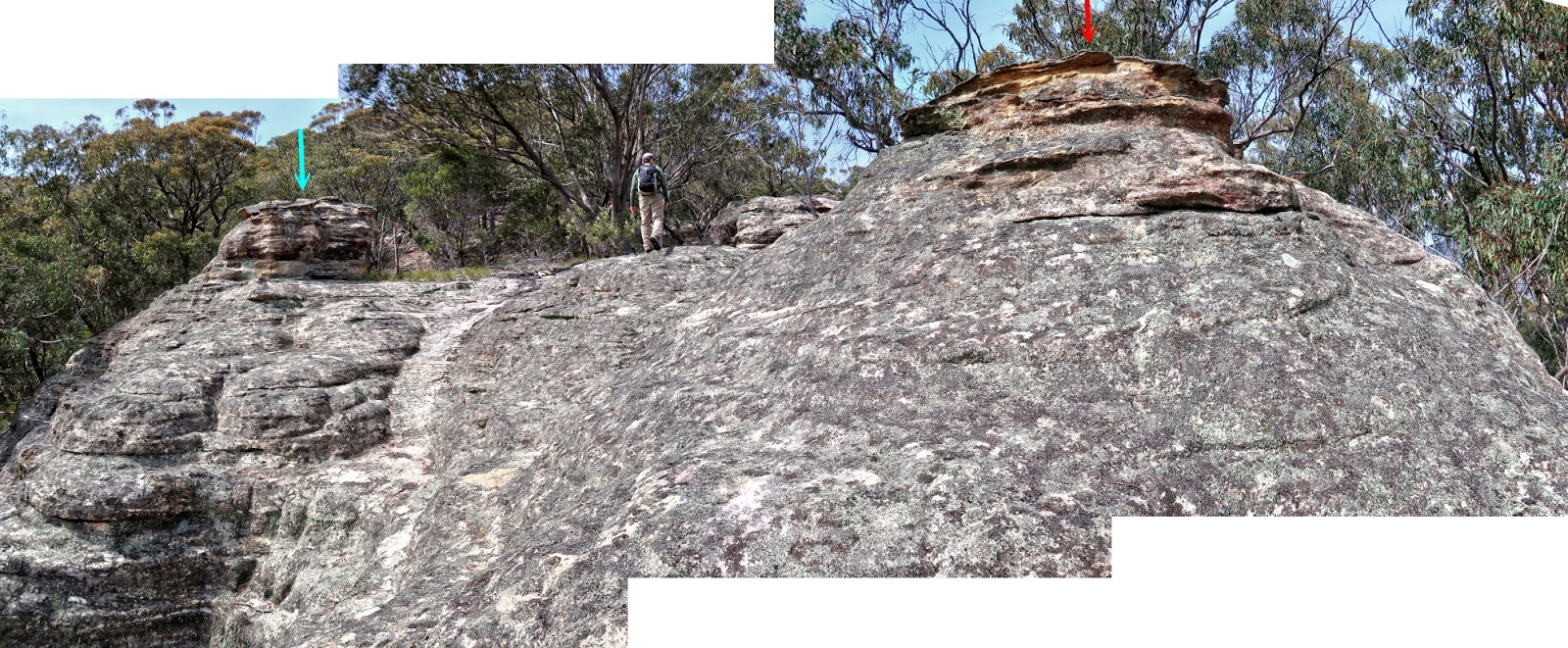
10) Moving along ...
We come to another set of rocks.
- Red/cyan arrows: Same as the red/cyan arrows
in photo #11

11) Closer to the rocks of photo #10.
- Red/cyan arrows: Same as the red/cyan arrows
in the previous pic
12) From a slightly different angle ...
This picture is the left half of previous pic.

13) YM climbs to top of the cyan-arrow-pointed
rock of photo #11.
(Photo taken from top of the red-arrow-pointed
rock, also of photo #11)

Lookout 2
GR 239 535
14) Another view along the Mt Marsden ridge.
- Upper pic:
• Red arrow: Haystack Mountain ...
towards west
- Lower pic: YM on top of the rock
• 2 red arrow, left to right:
1 Haystack Mountain
2 Church Mountain

15) 180-degree panorama from the lookout.
- 5 red arrows, left to right:
1 Bradleys Head
2 Fitzgerald Mount
3 Haystack Mountain ... west-ish
4 Church Mountain
5 Baldy Peak ... north-west-ish

Flora along Mt Marsden Ridge
16) Grass Tree ... which species ?

17) Tea Tree flower ... which species ?

18) Isopogon anethifolius
(Narrow-Leaf Drumsticks).

To Mt Marsden summit
19) Passing this rock.
(All 3 pics below are of the same rock.)
- Yellow arrows: Direction of our walk
- Middle & lower pics: Looking back at the rock

20) Looks like Mt Marsden summit ...
but no, not yet.
- The summit is behind the rise
and can't be seen yet.

21) The 2 pic below are of the same rocks.
- We are going through them ...
follow the yellow arrows.

Mt Marsden summit
22) Finally we are facing Mt Marsden summit,
about 1030 meters in elevation.
- It is quite flat around here.
You hardly recognize it is as the summit.

Lookout 3, just south of Mt Marsden summit
Boundary of GR 240 523 / 241 523.
A few steps south of the summit.
23) View from the lookout.
- This view is centred toward south ...
towards Camp Flat area.
- Red arrow: 1040-meter Genowlan trig
- Red dotted line: Glen Alice Road

24) Zooming to the middle of previous pic ...
towards south.
- Red arrow: 1040-meter Genowlan trig

25) Plenty of interesting Grass Trees
near the lookout and the summit area.
- Left pic: 2 trunks, 3 heads
- Right pic: 1 trunk, 2 heads

Lookout 4, west of Mt Marsden summit
GR 240 523
On the west side of the summit
26) We are heading to the lookout.
- Upper pic: The lookout is just ahead.
- Lower pic: This is it, the lookout.

27) YM and I at the lookout.

28) Panorama from the lookout
towards Camp Flat area.
- Upper pic: Centred towards south
• Background of previous pic
is the left side of this pic.
• Red arrow: 1040-meter Genowlan trig
• Red dotted line: Glen Alice Road
- Lower pic: Centred towards west.
(Continuation to the right of the upper pic)
• 4 red arrows, left to right:
1 Bradleys Head
2 Fitzgerald Mount ... west-ish
3 Haystack Mountain
4 Church Mountain

Two pagodas we are going to climb
29) We now head towards 2 pagoda-like rock
formations east of Mt Marsden summit.
- 3 red arrows, left to right:
1 Most interesting part of the Mt Marsden trip
is to climb this pagoda.
Not easy to climb, hence interesting 😊
2 On the other hand, this pagoda is easy.
3 Tayan Pic, east-south-east-ish ...
I will climb it in 2019-March.

Lookout 5 - a rocky outcrop
GR 242 525, almost at GR 243 525
30) While on our way to the 2 pagodas
mentioned in the previous pic,
we pass by and stop at this rocky outcrop.
- Lower pic: Red oval of the upper pic

31) View from the rocky outcrop.
- Towards north-ish

To the easy-to-climb pagoda
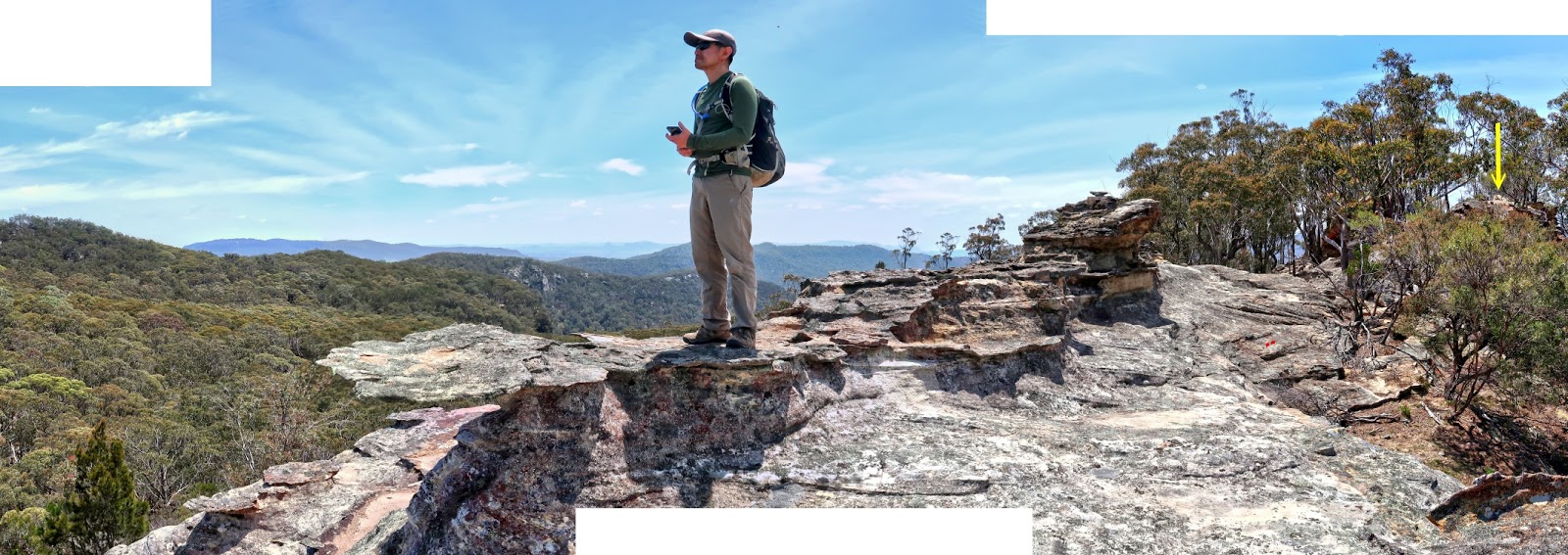
32) Close to the easy-to-climb pagoda ...
It is behind the trees.
- Yellow arrow: Direction we are going ...
We'll climb the pagoda from the left side.

33) Passing this interesting rock.
- It is located between the 2 pagodas
mentioned in photo #29.
- And is to the left of the pagoda in the prev pic.

Easy-to-climb pagoda
34) This is the top of the easy-to-climb pagoda,
GR 245 524.
- Peak in the background: Mt Marsden summit

35) Another view of the top of the pagoda.
- Peak in the background: Mt Marsden summit
- Yellow arrow: Lookout 5, a rocky outcrop,
photos #30 and #31

36) This and the next 3 pics, photos #37 #38 #39
form a 360-degree panorama
from the top of the pagoda.
- Yellow arrow: Harder-to-climb pagoda ...
We are going there next.
- Red arrow: Tayan Pic, east-south-east-ish ...
I will climb it in 2019-March.

37) (Continuation to the right of previous pic)
- This pic is centred towards south;
and is similar to the upper pic of photo #28.
- Red arrow: 1040-meter Genowlan trig
- Red dotted line: Glen Alice Road

38) (Continuation to the right of previous pic)
- Red arrow: Mt Marsden summit ... towards west
- 2 yellow arrows, left to right:
1 Lookout 6 ... Refer to photo #48.
2 Lookout 5, a rocky outcrop ...
Refer to photos #30 and #31.
- On the return trip:
• We'll go to lookout 6,
the yellow arrow on the left.
• As it is not possible to go directly
to the summit from there
(a non-climbable cliff in between),
we'll return to lookout 5 instead,
the yellow arrow on the right.
• From there to the summit.
• Then back to the car.

39) (Continuation to the right of previous pic)
- This pic is centred towards north.
- Its middle part is similar to photo #31.
- YM is looking at Mt Marsden summit,
the previous pic.
- Yellow arrow: Harder-to-climb pagoda ...
We are going there next.
- Continuation to the right of this pic is photo #36,
thus completing a 360-degree panorama.
Harder-to-climb pagoda
We've climbed down the easy-to-climb pagoda ...
40) ... Now approaching
the harder-to-climb pagoda, GR 245 525.
- We'll climb it from the far side.

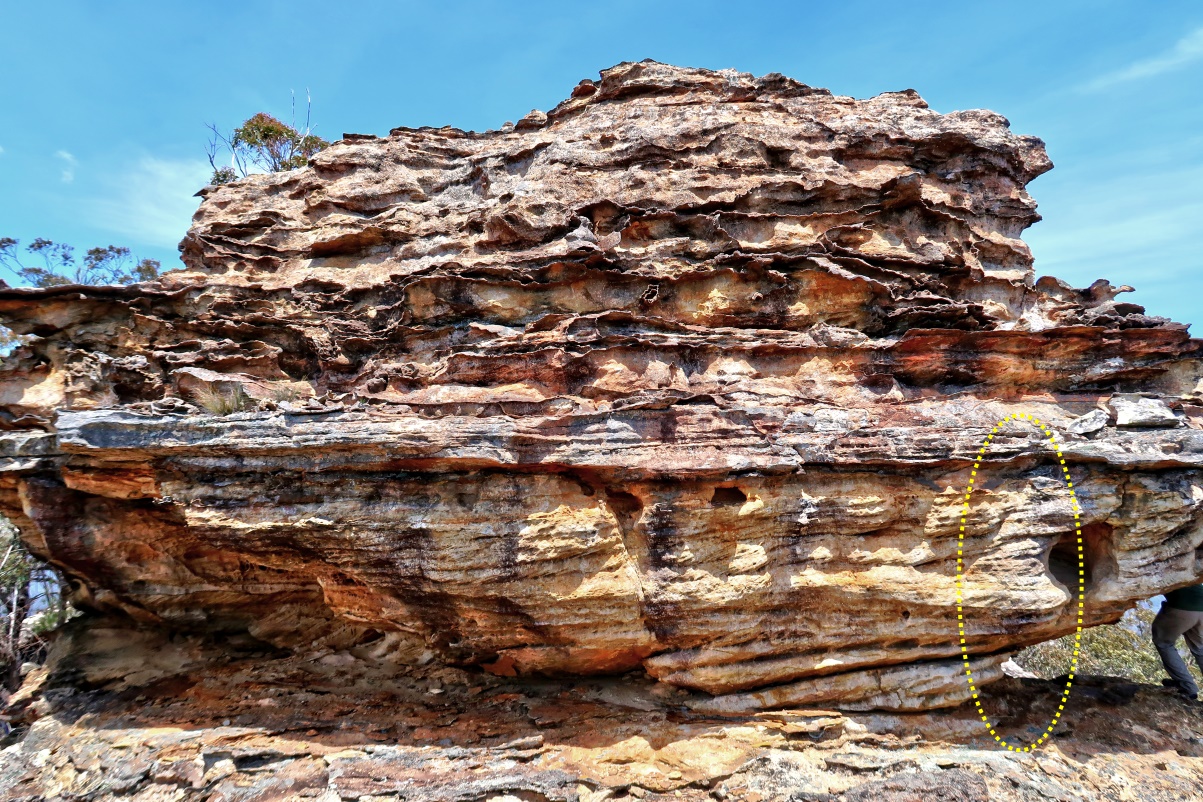
41) This is the pagoda we are going to climb.
- We are now on the far side of the pagoda
of the previous pic.
- Yellow oval: Where we'll be climbing up ...
Refer to photo #43.
- Mt Marsden is on the right side of the pic.

42) Another look at the same pagoda.
- Yellow oval: Where we'll be climbing up ...
Refer to photo #43.
43) The most interesting part of the
Mt Marsden trip is to climb up this pagoda.
- Here, YM is in action :-)
From the 2 pics below, it looks
as if there are plenty of footholds.
But the pictures are illusory.
There isn't any meaningful foothold.
You just have to haul yourself up by your arms
to the ledge ... not easy :-)

44) I made it to the top of the pagoda :-)
- YM is here with me.
But I don't have a photograph of him here :-(
- This pic and photos #45 and #46
form a 360-degree panorama.

45) - Upper pic:
(Continuation to the right of previous pic)
- Middle pic:
(Continuation to the right of the upper pic)
- Lower pic:
(Continuation to the right of the middle pic)
• Tayan Pic, east-south-east-ish ...
I will climb it in 2019-March.
• Right edge of this pic is towards south-ish.

46) (Continuation to the right of previous pic)
- Red arrow: The easy-to-climb pagoda ...
We came from there.
- Left edge of this pic is towards south-ish.
- Continuation to the right of this pic is photo #44,
thus completing a 360-degree panorama.

47) Time to climb down the pagoda.
- YM is at the same spot where his hands were
in photo #43 when he was climbing up.
- I'll lower myself down from the red circle.

Return to Mt Marsden summit
After climbing the pagodas,
it is time to return to Mt Marsden summit ...
But first, walk along the cliff edge
to another rocky outcrop, lookout 6.
Lookout 6
GR 243 524
48) At lookout 6 on the cliff edge.
- 3 red arrows, left to right:
1 Harder-to-climb pagoda
2 Easy-to-climb pagoda
3 Tayan Pic, east-south-east-ish

Back at Mt Marsden summit
49) Mt Marsden summit is somewhere in front :-)
- As mentioned in photos #22,
it is very flat around the summit.
- Compared to photo #22, we are now facing
the summit from a different direction.

Return to car
To return to the car, just retrace our steps.
50) We come to the same rock formations
as in photos #11 and #12.
- Here, we are facing north-ish;
whereas in photo #11,
we are facing south-ish.
- Upper pic:
• YM is on the right edge.
• The rock near the left edge is the same
as the rock on the right side of photo #12.
• The rock on the right side of the pic
is the same as the red-arrow-pointed rock
in photo #11.
- Lower pic:
(Continuation to the right of the upper pic)
• YM is on the left edge.
• The rock near the right edge is the same as
the cyan-arrow-pointed rock in photo #11.

51) Now almost at Glen Alice Road and my car.
- About to cross a run-down fence
across the centre of this pic ...
The same fence as in photo #3.

Comment
The entire trip is 5 hours ...
A nice little saunter suitable for winter months
when daylight hours are shorter.
Make sure you climb the pagodas,
photos #32 to #47 ...
They are interesting !
Next time call in for a coffee not many go up there I back right onto there
ReplyDelete