2020 May: Day trip, NSW, Australia
- Stanwell Creek - Illawarra Escarpment SCA
- Ladder up the cliff from Stanwell Creek
- Coalcliff & Stanwell Dams
- Kellys Falls - Garrawarra SCA
Preview
A quick preview of the photos are in this link:
https://drive.google.com/file/d/1XlzCICowrtMHefIHHVAZwPimOj7G4QxS/view?usp=sharing
The trip is best remembered by the ladder up the cliff from Stanwell Creek. (Photographer: Alan)

Kellys Falls is very nice too. (Photographer: Alan)

Prolog
My interest in this trip was piqued 3 weeks ago in 2020-04, when a group of us went up the south arm of Stanwell Creek.
Photographs and trip report are in this link:
https://mntviews.blogspot.com/2020/04/sea-cliff-bridge-coalcliff-dam.html
It was interesting. So now, 3 weeks later, we are here to explore the north arm of Stanwell Creek.
- 8 of us: Alan (leader), Cathy, Johnson, Lily, Lisa, Stanley, Yus, Paul (me)
I like Stanwell Creek.
- Low water level
- Clean, hardly any mud, just boulders and waterfalls
- Pleasant boulder hopping along the creek :-)
Map
LPI 1:25,000 scaled 9029-1S Appin
Map 1) The relevant part of the 1:25,000 topographic map

GPS tracklog file & route
The GPX tracklog file of our walk can be downloaded from:
https://drive.google.com/file/d/1tTtUaxCPzgEv7H6Z3_DutwfTPRYmpF35/view?usp=sharing
Map 2) The same GPS tracklog is in the following 1:25,000 topographic map (dark brown, clockwise direction):
- 2 purple dotted arrows: We could have taken these shortcuts :-)
- 2 blue arrows at centre of map, and close to each other, left to right: Lookouts 10 and 9 at Stanwell Tops
- 8 other blue arrows, clockwise from right edge:
1 GR 146 104 ... Carpark at Beach Road, start of the walk
2 GR 143 098 ... (near bottom right corner) Lookout 7 to Illawarra Railway
3 GR 138 097 ... Lookout 8, towards Coalcliff & Sea Cliff Bridge
4 GR 136 098 (almost at 137 098) ... Lookout 5, towards Stanwell Park
5 GR 126 101 (almost at 126 100) ... Lunch spot at Coalcliff Dam
6 GR 125 107 ... Ladder to climb up the cliff
7 GR 125 107 ... Waterfall that can't be climbed over ... Stanwell Creek flows over the waterfall.
8 GR 140 124 ... (near top right corner) Unnamed waterfall over Gills Creek

- Start at a carpark at Beach Road, Stanwell Park
- Get onto Wodi Wodi Walking Track
- To a lookout ... For the purpose of this report, it is labelled as lookout 7.
- Off-track to lookout 8
- To lookout 5
- To junction of Wodi Wode Walking Track & Stanwell Creek
- Walk upstream of Stanwell Creek
- To a waterfall on Stanwell Creek that cannot be climbed over
- Climb up a ladder to get over the cliff
- To Coalcliff Dam
- To Stanwell Dam
- To unnamed waterfall over Gills Creek
- To Kellys Falls
- To Stanwell Tops Lookout
- To lookout 9 at Stanwell Tops
- To lookout 10 at Stanwell Tops
- Back to carpark
Timeline & Distance
Park Stanley & Alan's cars at GR 146 104, a carpark on the south side of Beach Road, Stanwell Park.
07:24 0.0 km Start walking
07:45 1.3 km At junction of Lawrence Hargrave Drive & Wodi Wodi Walking Track
07:51 1.65km At a lookout to Illawarra Railway ... For the purpose of this report, It is labelled as lookout 7
07:52 1.65km Leave lookout
07:58 2.0 km Leave Wodi Wodi Walking Track ... bushbash uphill, south-westerly direction
08:18 2.45km At lookout 8, towards Coalcliff & Sea Cliff Bridge
08:28 2.45km Resume walking
08:32 2.65km At lookout 5, towards Stanwell Park
Lookout 5 is on Forest Walking Track ("Forest Path" in OpenStreetMap)
08:37 2.65km Resume walking
08:52 3.4 km At junction of Forest Walking Track (Forest Path) and Wodi Wodi Walking Track
09:12 4.2 km At junction of Wodi Wodi Walking Track and Stanwell Creek
09:21 4.4 km At confluence of Stanwell Creek and its southern tributary
09:26 4.4 km Resume walking upstream along Stanwell Creek
10:04 4.8 km A car-size boulder tumble down from cliff on north side of Stanwell Creek
At a distance only 50 meters downstream of us !!! That was close !!!
10:47 5.15km At a waterfall where Stanwell Creek tumbles down from high up the cliff
11:00 5.2 km Resume walking ... southward along base of cliffs
11:10 5.25km At bottom of a steep slope which we proceed to climb up
11:36 5.3 km At bottom of ladder
11:57 5.3 km At top of a narrow vertical slot above the top of the ladder
11:59 5.3 km Resume walking
12:28 5.7 km At a firetrail connecting Stanwell Dam and Coalclff Dam
12:41 6.5 km Stop for lunch near east corner of Coalcliff Dam
Lunch
13:00 6.55km Resume walking
13:14 7.5 km At Stanwell Dam south-east corner (The dam is all silted up. OpenStreetMap no longer gives it a name.)
13:17 7.65km Resume walking
14:27 11.5 km At Lawrence Hargrave Drive
14:29 11.6 km At junction of Lawrence Hargrave Drive and access road to Garrawarra State Conservation Area
14:32 11.92km Leave access road, enter into Kellys Falls Track
14:43 12.5 km Leave Kellys Falls Track, turn south into a narrow foot track towards Hacking River
14:53 12.7 km At Hacking River
15:05 12.95km At an unnamed waterfall over Gills Creek
15:21 12.95km Resume walking
15:24 13.05km At Kellys Falls
15:47 13.2 km Resume walking
16:20 14.07km At junction of Lawrence Hargrave Drive and Stonehaven Road
16:25 14.42km At Stanwell Tops Lookout, towards Stanwell Park
16:26 14.42km Resume walking
16:39 15.15km At lookout 9, towards Stanwell Park
Change GPS battery
16:42 15.2 km Resume walking
16:43 15.25km At lookout 10, towards Stanwell Park
16:46 15.25km Resume walking
16:47 15.35km At as far west as we are willing to go ... as it is getting dark. (Sun sets at 17:00.)
17:05 16.4 km At pedestrian tunnel under Stanwell Park railway station
17:23 17.5 km Back at carpark
==============================================
Total: 9 hrs 59 mins
17.5 km Distance is from Google Earth
Pictures - Carpark
Carpark is on the south side of Beach Road in Stanwell Park - GR: 146 104.
1) 180-degree panorama from carpark ~~~
- Upper pic: We park our cars here and start walking. Stanley's white ute is at the left edge.
- Lower pic: (Continuation from the right of the upper pic)
• Left to right: Yus, Stanley
• Yellow & blue arrows: Soon, we'll be walking along the arrows.
• Upper-most yellow arrow: That part is off-track. (The other arrows are on-track.)

Beach Road
2) 180-degree panorama taken on Beach Road, not far west of where previous pic was taken ~~~
- Stanwell Creek is the main feature of both pics below.
- Upper pic:
• Yellow arrow: Direction of walk
• Carpark: Just beyond the left edge of this pic
• Black oval: A shortcut from the carpark is to walk on the beach there (instead of along the yellow arrow).
- Lower pic: (Continuation from the right of the upper pic)
• Yellow & blue arrows: We'll be walking along the arrows.
• Upward pointing yellow arrows: That part is off-track. (The other arrows are on-track.)

Stanwell Park beach
3) Stanwell Park beach ~~~
- White arrows: We could have taken a shortcut from the carpark by walking along the beach cum sandbank.
- Upper pic: Carpark is not far beyond the left edge.
- Lower pic: (Continuation from the right of the upper pic)
• Our group is on the right edge.
• Yellow arrow: We'll soon be walking along Kallaroo Avenue.

4) We are about to enter the north end of Kallaroo Avenue, the tail end of the yellow arrow in previous pic.
- Left to right: Lisa, Stanley (the small figure), Johnson, Yus, Cathy, Lily, Paul (me)
- Yellow arrow: We came along there.
- White arrows: We could have taken a shortcut along the beach cum sandbank.
- Carpark can't be seen from here. It is just to the left of the left-most white arrow.
- Photographer: Alan

The stairs of above pic leads to Kallaroo Avenue.
Kallaroo Avenue leads to Lower Coast Road,
then Lawrence Hargrave Drive.
From Lawrence Hargrave Drive, duck under Illawarra railway to get onto Wodi Wodi Walking Track.
Wodi Wodi Walking Track
5) On Wodi Wodi Walking Track ~~~
- Upper pic: Just after ducking under Illawarra Railway

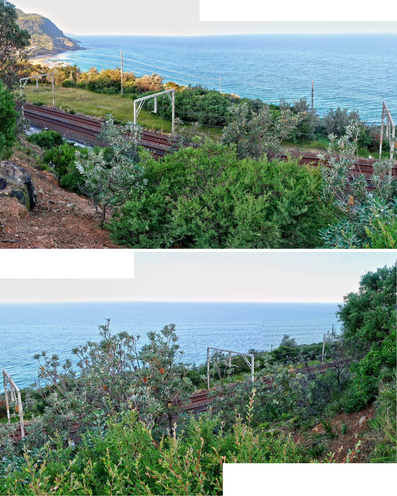
6) Illawarra Railway from a lookout at a slight diversion from Wodi Wodi Walking Track ~~~
- For the purpose of this report, the lookout is labelled as lookout 7 (GR 143 098).
- Lower pic: (Continuation from the right of the upper pic)
Climbing up a Ridge
We could have kept walking on Wodi Wodi Walking Track.
However, Alan wants to jazz up the trip.
Not long after walking on Wodi Wodi Walking Track, we go off-track, turn south-west to climb up a ridge.
7) Off-track up a ridge ~~~
- Upper pic, left to right: Yus, Lisa, Johnson
- Lower pic, left to right: Lily, Cathy, Alan

8) Having fun climbing up a trunk ~~~
- Upper pic, left to right: Lily, Cathy, Lisa, Johnson (halfway up the trunk), Alan
- Lower pic, left to right: Johnson, Alan

9) Interesting pattern on the ceiling of a rock

10) At lookout 8, GR 138 097 ... We take turns to have our photographs taken.
- Randomly :-) presenting 2 pictures here: Cathy and Lily.
- You can just make out Sea Cliff Bridge in the middle of the pic.

Forest Walking Track
11) Forest Walking Track ("Forest Path" in OpenStreetMap) ~~~
- Yellow arrow: Direction of walk

12) We come to lookout 5 with a nice view towards Stanwell Park.
- Yellow arrow: The lookout, GR 136 098 (almost at 137 098)
- Lower pic: 3 guys in white on the left are from another group. The rest are our group.

13) Stanwell Park from lookout 5 ~~~
- Upper pic:
• Yellow dot: Where our cars are parked
• Cyan arrow: Stanwell Creek
- Lower pic: Lisa ... WOW, she seems very slim :-)

14) On Forest Walking Track ("Forest Path" in OpenStreetMap) towards Wodi Wodi Walking Track

Wodi Wodi Walking Track
Then on Wodi Wodi Walking Track
Junction of Wodi Wodi Walking Track & Stanwell Creek
Then come to the junction of Wodi Wodi Walking Track and Stanwell Creek.
15) At the junction, if one turns right and walk downstream for a few steps, one will come to a delightful waterhole.
This pic was taken 3 weeks ago.

More photographs of the waterhole are in this link:
https://mntviews.blogspot.com/2020/04/sea-cliff-bridge-coalcliff-dam.html
(Photos #48, #49, #50 there)
Today, with Alan leading, in his wisdom, he decides not to visit the waterhole even though it is only a few seconds away ...
16) ... Instead, we turn left immediately at the junction; and walk upstream.
- Yellow arrow: Direction of walk ... Follow Yus.

Walking upstream of Stanwell Creek
17) Walking upstream of Stanwell Creek ~~~
- Left pic: Lisa leading; followed by Cathy, Stanley, Lily; Johnson at rear
• Photographer: Alan
- Upper right: Stanley leading; followed by Cathy; Lisa at rear
- Lower right: Alan leading; followed by Cathy, Johnson, Lisa, Lily (hair only); Yus at rear

Junction of Stanwell Creek & its south arm
18) We come to the junction of Stanwell Creek and its southern tributary.
- Upper pic: Group photo by Lisa
• Left to right: Alan, Paul (me), Yus, Stanley, Johnson, Lily, Cathy
• Left yellow arrow: We'll continue upstream of Stanwell Creek.
• Right yellow arrow: Southern tributary of Stanwell Creek. I walked up there 3 weeks ago.
- Middle pic: A cairn (white circle) marks the junction.
• Left to right: Johnson, Stanley
• Left yellow arrow: Southern tributary of Stanwell Creek. I walked up there 3 weeks ago.
• Right yellow arrow: Today, we'll continue upstream of Stanwell Creek.
- Lower pic: These cairns are new. They were not here when Alan came through here few months ago.

Keep walking upstream of Stanwell Creek
19) Keep walking upstream of Stanwell Creek (ie its north arm)

20) Vines

21) Stanwell Creek makes a bend here.
- The creek flows along the cyan arrows.
- We walk upstream, along the yellow arrows.
- Alan is mucking around, up on a tree, white arrow.
- Johnson on the left
- Lily and Stanley on the right

22) The scene here is to the left of previous pic.

A waterfall on Stanwell Creek
23) We come to a waterfall.
- Alan leading, followed by Johnson; whilst the rest ...

24) (Continuation from the left of previous pic)
... Whilst the rest climb up on the left side of the waterfall.
- Left to right: Yus, Lily, Cathy, Lisa, Stanley

25) This is the slope we climb up in the previous pic.

Keep walking upstream of Stanwell Creek
26) 2 minutes after the waterfall of previous pics, we come to this scene.
- Lisa, photographed by Alan

More waterfalls
27) We come to another waterfall.
- Upper pic: Lisa
- Middle pic: (Continuation from the right of upper pic)
- Lower pic: (Continuation from the right of the middle pic)

28) Yet another waterfall ~~~
- Alan is on the left edge.

29) Same waterfall as the previous pic ... continuation from its left (To enlarge the image, click on it.) ~~~
- Alan has climbed up to the top-left corner.

Landslide
A minute after climbing over the waterfall of previous pic, we hear a loud thunderstorm.
I look up. It is clear blue sky.
Just when I am wondering how a thunderstorm could come about from a clear sky, I see a car-size boulder together with lots of dirt and dust tumbling down the north side slope, a little downstream of the waterfall.
WOW ! That is close !
If we were a few minutes late in coming up the creek, we could have been hit by the landslide !
Occupational health hazard of bushwalking !
Keep walking upstream of Stanwell Creek
30) Keep walking upstream ~~~
- Lower pic:
• Left to right: Lily, Cathy, Alan, Stanley, Johnson
• Easier is to climb up the gap where Lily is :-)

31) A small waterfall

32) Vines ~~~
- Left pic, left to right: Alan, Yus
• Photographer: Lisa
- Right pic, left to right: Stanley, Lisa

Final waterfall on Stanwell Creek
Grid Ref: 125 107
33) Lisa is the star in this last waterfall on Stanwell Creek. We won't be able to climb up the cliff from here.

34) Same waterfall, from a different angle ~~~
- Left to right: Yus, Lisa
- Unable to climb up further, we proceed to explore the cliffs south/left of the waterfall.

35) Same waterfall ... photograph taken by Alan from slightly south/left of previous pic ~~~
- Lisa

Ladder
We search around for a way up the cliff.
36) Lo and behold, 50 meters to the left (south) of the waterfall, we notice a ladder high up on the cliff !
- Photographer: Alan
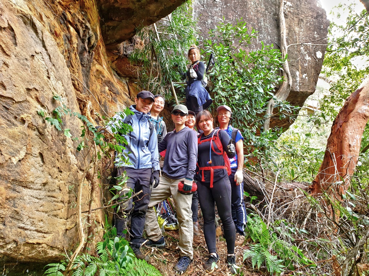
37) Just around the corner, left of previous pic, we found a way up. It is a near-vertical slope.
All credit to Yus who climbed up first and dropped a rope down for us.
- Left pic, left to right: Lisa, Paul (me), Lily
- Right pic: Cathy is climbing up.
- Photographer: Alan

38) Same slope as previous pic ... I'm at the top, looking down at Cathy climbing up.

39) Once up the slope, a few steps to the right is the bottom of the ladder, GR 125 107.
- On the ladder: Lily
- The rest, left to right: Johnson, Paul (me), Yus, Lisa, Cathy, Stanley
- Photographer: Alan
40) At top of the ladder, turn left, as Cathy is doing right now.
There is a narrow vertical slot to the left ... Refer to photo #41.

41) At top of the ladder is this narrow vertical slot. Climb straight up !!!
- This climb is difficult. If you slip, you'll be dead. But no problem for Lisa ... Refer to photo #42.
- Photographer: Alan

42) Lisa has almost climbed up the vertical slot and can smile now :-)
- It is a difficult climb, more like chimneying up. If you slip, you'll be dead !
- Well done Lisa ! You are alive !
- Yellow arrow: The way out is along the ledge.
- Photographer: Alan

43) Looking down at Yus climbing up ~~~
- Photo taken from the ledge of this and previous pics ... from somewhere further along the yellow arrow
- Yellow oval (top-left corner): Vertical narrow slot is down there.
- Yellow arrow: Same position as the yellow arrow of previous pic ... Climb up the narrow slot, then walk along the ledge.

To Coalcliff Dam
44) After the ladder, proceed further up a bit, there is this minor hurdle to climb over.
- Alan is helping Cathy.

45) Banksia - photographed when bushbashing towards Coalcliff Dam

Coalcliff Dam
46) Arrive at Coalcliff Dam.
- Blue arrow: Direction of walk along the dam wall
- Coalcliff Dam seems to have been decommissioned. Charles Bowden said it was used to supply water to the coal washery at Coalcliff.

47) Keep going along the blue arrow of the previous pic, we come to the spillway of Coalcliff Dam.
(To enlarge the image, click on it.)
A little bit of rain is coming down now. You can see the tiny white rain drops against the dark coloured trees.
The rain won't stay long. It'll soon go away.

48) At south-east arm of Coalcliff Dam ~~~
- Upper pic: The spillway
• Yellow dotted line: We'll have lunch there ... Refer to photo #49.
- Lower pic: Zooming into the upper half of the upper pic

49) Lunch by the bank of Coalcliff Dam, at the yellow dotted line of photo #48's upper pic
- Grid Ref: 126 101 (almost at 126 100)
- Left to right: Lisa, Alan, Paul (me), Yus
- Photographer: Johnson

50) Retracing our steps along Coalcliff Dam wall ... We are heading now towards Stanwell Dam.

Stanwell Dam
51) Approaching Stanwell Dam ~~~
- Red arrows in both pics below: They point to the same tree.
- Upper pic:
• Left to right: Cathy, Stanley, Lisa, Johnson, Alan
• Blue dot: The low pic is taken around there.
- Lower pic:
• Photograph taken near the blue dot of the upper pic
• Stanwell Dam is all silted up ... Refer to photo #52.

52) Lisa at Stanwell Dam (To enlarge the image, click on it.) ~~~
The dam is all silted up. We are well inside the dam.
In fact, OpenStreetMap doesn't label this place as a dam. It is simply part of Stanwell Creek.

53) This place used to be the dam wall of Stanwell Dam. But now water runs over it and is part of Stanwell Creek.
- If you follow the water downstream (to the right), you will be at top of the waterfall in photos #33, #34, #35.
- Left to right: Alan, Cathy, Johnson, Lily, Yus, Stanley, Lisa

To Kellys Falls
54) On our way to Kellys Falls ~~~
- Lower left: Lisa crossing Kellys Creek

Kellys Falls - upper reach
We are now in Garrawarra State Conservation Area.
This area was once privately owned and developed in the 1930s by Henry Halloran as a place of rest and recreation for visitors wanting to escape the hustle and bustle of Sydney. Mr Halloran established the Princess Marina and Kellys Falls walking tracks, both incorporating lookouts and offering glimpses of the falls and down Otford valley.
55) At the upper reach of Kellys Falls ~~~
- In photos #62 to #70, we'll be at the bottom of the fall.

Kellys Falls Track
56) On Kellys Falls Track ... We are heading to the bottom of Kellys Falls.

57) View to Kellys Falls from at a lookout on Kellys Falls Track

Track to Hacking River
58) To reach the bottom of Kellys Falls, at some point, get off Kellys Falls Track, and down this rough narrow track. It will lead to Hacking River. (Then from Hacking River, walk upstream to Kellys Falls.)
- Lily is the one in these pics.

Hacking River
59) Walking along Hacking River ... upstream first to a waterfall over Gills Creek, then to Kellys Falls

Waterfall over Gills Creek
Grid Ref: 140 124
60) Unnamed waterfall over Gills Creek ~~~
- Left to right: Lily, Cathy

61) Unnamed waterfall over Gills Creek ~~~
- Johnson is at the left side of the pic.

Kellys Falls
62) We arrive at Kellys Falls, about 100 meters to the west of the above unnamed waterfall.
- 2 white arrows: Paul (left), Stanley & Johnson (right)
- Photographer: Alan
63) Kellys Falls from another angle ~~~
- Stanley

64) (Continuation from the left & bottom of previous pic)
- Upper pic: Plunge pool of Kellys Falls
- Lower pic: (Continuation from the left of the upper pic)
• Yellow arrows: We'll leave Kellys Falls along the arrows.
• The guy in this pic does not belong to our group.
• Right side of the pic: Plunge pool
• Left side: The start of Hacking River

65) Kellys Falls and beautiful Cathy ~~~
- 2 red arrows: Alan (upper), Johnson (lower) ... See also photo #66.

66) The 2 pics below are the upper and lower parts of previous pic.
- Upper pic: 2 white arrows: Alan (upper), Johnson (lower) ... Same as the 2 red arrows of previous pic
- Lower pic: Beautiful Cathy

67) Johnson is standing at where I was in photo #62.

68) Kellys Falls ... photo taken at the same spot as previous pic

69) Plunge pool of Kellys Falls ~~~
- Upper pic: Johnson
• Picture taken by Alan at where he is standing in photos #65 and #66
• Johnson is one level below Alan.
- Lower pic:
• Picture taken at where Johnson is in the upper pic; and same spot as I was in photo #62
• Red oval: Alan ... He took photo #62 from there.

70) About to leave Kellys Falls ~~~
- Paul (me)
- Yellow arrow: Route to Kellys Falls from the unnamed waterfall over Gills Creek (photo #60 and #61)
- Blue arrow: The way we are leaving Kellys Falls now.

Leaving Kellys Falls
There is a rough foot track between Kellys Falls and Princess Marina Track.
71) On the rough foot track ... Lisa is climbing up.

72) The rough foot track passes by the side of this rock. Alan, Johnson and Stanley just want to have a thrill. They take turns in climbing it :-)
- Stanley is in this set of photographs.

73) Passing an overhang ~~~
- White oval: Someone had spray painted these words:
2012
DT

Princess Marina Track
74) Now on the well-maintained Princess Marina Track

75) A nice chair built from rocks on the south-east side of Princess Marina Track ~~~
- Left pic: The back of the chair facing Princess Marina Track
• Left to right, on the roof: Alan, Stanley, Johnson
• Photographer: Lisa
- Right pic: The chair, facing the bush

76) Desiccated flower of Doryanthes excelsa (Gymea Lily)
(I am sitting on the chair of previous pic, facing the bush.)

Stanwell Tops Lookout
77) At Stanwell Tops lookout overlooking Stanwell Park ~~~
- Yellow arrows in both pics below: Our route in the morning
- Upper pic, left to right: Stanley, Alan, Johnson, Lily
- Lower pic: Stanwell Park
• Cyan dot: If not for the trees, we would be able to see our cars parked there.

Lookout 10
78) At lookout 10 overlooking Stanwell Park ~~~
- Upper pic:
• Cyan dot: Where our cars are parked
• Yellow dots & arrows: Our route in the morning
• White oval: Illawarra Railway
- Lower pic: Lisa

Wodi Wodi Walking Track to Stanwell Park Railway Station
79) On Wodi Wodi Walking Track from Stanwell Tops to Stanwell Park Railway Station
- Upper pic: Yus
- Lower pic: Left to right: Alan, Yus

Stanwell Park Railway Station
80) At Stanwell Park Railway Station
- Lower pic: Cathy in the pedestrian tunnel under the station ... Photographer: Stanley

Stanwell Creek at Stanwell Park
81) Stanwell Creek by the side of Beach Road at Stanwell Park ... We are almost back at our cars.
- Upper pic: Facing west, upstream
• Photographer: Yus
- Lower pic: Facing east, downstream
• Cyan dot: Where our cars are parked

Miscellaneous
82) Trametes versicolor (?) at Kellys Falls (Usually brownish colour ... It is black here.)
Lantana camara (Common Lantana) on Wodi Wodi Walking Track near Stanwell Creek

Back at carpark
Sunset is at 5:00 pm.
We are back at the carpark at 5:23 pm ... just before everything turns pitch black :-)
Perfect timing !
And so ends an interesting trip !
Thanks to Alan who led all the way.
Other trips in Illawarra Escarpment SCA
3 weeks ago in 2020-04, a group of us went up the south arm of Stanwell Creek ... from Sea Cliff Bridge to Coalcliff Dam.
Photographs and trip report are in this link:
https://mntviews.blogspot.com/2020/04/sea-cliff-bridge-coalcliff-dam.html
No comments:
Post a Comment