2012 July:
Mt Zeil
Highest mountain in NT, Australia
2017-05 Post Scrip
Please read this section first !
The management of Glen Helen property
are no longer interested in people
ringing them about climbing Mt Zeil.
And so, NT Parks & Wildlife has recommended
the route below.
- The drive to there (red line in the map below)
is parallel and to the west of the route
I'll describe in option 1 in the section titled
"To get to the base of Mt Zeil".
- The blue & green lines are possible
walking routes to Mt Zeil.

The corresponding KMZ file
can be downloaded from:
https://drive.google.com/file/d/1zb4uwwKYwCXdFo1vN785vHJaX2tcr7oe/view?usp=sharing
NOTE !
Gary Junction Road seems to have changed
its name to Kintore Road.
Happy climbing !
Prolog of Prolog
All the hiking and running have taken
their toll on my feet.
In 2011 November, the bottom of the heel
at one foot was sore.
I thought it was just a temporary set back
to my hiking obsession.
Two weeks and I should be back on my feet ...
I said to myself.
Plantar Fasciitis
A month later, the heel was still in pain.
Looked up Google.
Found it was Plantar Fasciitis.
Love learning big words like this.
And it sounded serious !
Podiatrists & Charlatans
Straight away, I consulted a podiatrist.
She asked me to take off my pants
and asked me to walk here and there
and all over the room.
But she must have had blinkers on,
because she couldn't see a potential
star stripper in me !
Soon afterwards
she sent me packing out the door
and said it was a mild case,
just rest the foot would do.
She didn't even give me a medical certificate
for a few weeks of sick leave 😭
* * * * * * * * * *
By 2012 January, the foot was still not healing,
so off to see another podiatrist.
Given my prior experience,
you can understand I picked a guy this time.
But he must have graduated from
a business school, major in out-sourcing,
because he didn't bothered to treat me.
Instead, he sent me to an acupuncture specialist.
And this was the first time I was treated
with a needle.
Wow, what a baptism !
When the needle pierced into
the middle tender itchy part
at the bottom of the foot,
it was painful.
I prefer Plantar Fasciitis anytime !
After many acupuncture sessions,
the foot still refused to heal.
Gggrrrr !!!
* * * * * * * * * *
So, off to see a 3rd podiatrist,
and also visited another massage
and acupuncture practitioner.
The 3rd podiatrist taped up my foot as a cure.
By that time, I had already tried various self-helps:
- Rolled freezing cold water bottle
at the bottom of the foot.
- Immersed foot in hot water with epsom salt.
- Rolled a tennis ball at the bottom of the foot.
- Various foot stretching exercises.
But none of them had any effect
in curing the foot.
And as expected,
taping the foot was also ineffective.
Strassburg Sock
By 2012 March, panic set in.
Am I going to be grounded forever ???
Went Googling on the Internet for a cure,
any cure.
Saw a Strassburg Sock advertisement:
https://thesock.com/
Bought the Sock without much
of a second thought.
Try anything is better than being grounded.
Here is my leg wearing the sock.
Don't you just love my sexy leg !!!

I wore the Sock to sleep every night.
It worked wonders !!!
The guy who invented it deserves a Nobel Prize !
In a matter of days, the heel pain subsided a lot.
A month later, the pain disappeared completely.
Phew !!!
What a relief !
Prolog
Time to plan another mountain climb ...
Mt Zeil, highest mountain in NT.
While not high, at 1531 meters only,
Mt Zeil is rarely climbed, being remote
in a semi-desert area far from civilization.
There is no road to its base
and no trail to the summit.
On July 8, I teamed up with Ricky and Jeremy,
met them at Alice Springs airport,
hired a 4-wheel-drive,
picked up groceries from a supermarket,
then proceeded to drive to the base
of Mt Zeil for the adventure.
All 3 of us are on a mission
to conquer the highest mountain
in every Australian States/Territories.
Mt Zeil is one of these mountains to be ticked off.
By the way, Jeremy is a very experience hiker.
He has a hiking blog:
http://jez-hiking.blogspot.com.au/
I am most glad to have him coming to this trip.
His account of our climb is in:
http://jez-hiking.blogspot.com.au/2012/07/mt-zeil-nts-highest-peak-state-8.html
Maps
- NATMAP series: 1:250,000 scale, SF53-13
Hermannsburg (Northern Territories)
- There is a 1:50,000 scale contour map
showing the Mt Zeil area and a dotted line
suggesting a possible route to the summit.
At the time of this writing,
the map is not for distribution.
You will have to ask the ranger for it.
( Post Script: In June 2013,
I notice the map is posted at
http://www.nigel-roberts.info/Zeil-web-album/images/Zeil-044_jpg.jpg )
To get to the base of Mt Zeil
- From Alice Springs, drive north along
Stuart Highway (Highway 87).
- Shortly afterwards, turn west to Tanami Rd (Route 5).
- Just a bit over an hour later, turn west
into Gary Junction Rd (an unsealed road).
NOTE !
Gary Junction Road seems to have changed
its name to Kintore Road.
1:250,000 scale map of Mt Zeil

Now, 2 options:
1.
Drive on Gary Junction Rd (refer to above map)
until you are almost directly north of Mt Zeil.
Get off road by turning south towards Dam 23,
then keep going southward to Bore 15;
and keep going as far as the car can go.
As the land there belongs to
Narwietooma property,
you should get permission from
the property owner to drive there.
2.
We take the 2nd option ...
On Gary Junction Rd, not far west from Dam 23,
turn south-west into an unseal road
towards Glen Helen property.
Shortly after the turn, there is fork. Keep right.
(The left fork goes into
Mbunghara aborigines community.)
Soon, the road encounters
- a fence running east-west, and
- a gate which is the entry to Glen Helen property.
The gate is not locked.
May be because weeks earlier,
I rang the owner for permission to enter his land.
If you want to climb Mt Zeil
from Glen Helen property too,
you should also seek the owner's permission.
He is quite an amicable chap.
After the gate, the road leads to
Dashwood Crossing Bore.
At the Bore, get off the road,
cross Dashwood Creek
which should be dry during the Winter months.
After crossing the creek,
there is a faint 4-wheel-drive track.
Follow it as best as you can.
If you lost the track,
just drive in a south-east direction
to as close as possible to the base of Mt Zeil.
We left Alice Springs just a bit before 3pm.
Reached the base of Mt Zeil around 5:30pm.
So it was a 2 and a half hour drive.
We set up camp for the night.
Jeremy got a fire going
which kept us warm while we ate our dinner.
Route to summit
There is no trail to the summit.
You need to find your own way,
or follow the dotted line in the
1:50,000 contour map ... this link:
http://www.nigel-roberts.info/Zeil-web-album/images/Zeil-044_jpg.jpg
For what it is worth,
you can download our GPS route from:
- GPX file ... to the summit:
https://docs.google.com/open?id=0B877-h5SCJaSNDNvWjgwZjZWTjQ
- KML file ... to the summit:
https://docs.google.com/open?id=0B877-h5SCJaSVVhlLS1idzhldE0
But probably best is to get onto a ridge
and just follow the ridge top
all the way to the summit.
On the return trip, we stick more closely
to this principle:
- GPX file ... return from summit:
https://docs.google.com/open?id=0B877-h5SCJaSLWFwUjRRQnBoOUE
- KML file ... return from summit:
https://docs.google.com/open?id=0B877-h5SCJaSYU1pOG81SEVBVGM
Condition of the route
It is hard to walk on this mountain.
The entire area is covered with loose stones ...
I've never encountered anything like it.
In every step, you can't avoid
not stepping on a stone.
And when you step on one, your foot rolls,
and you feel you are tripping.
Luckily we all have hiking poles
which definitely help with the walking.
Also, spinifex grass are everywhere.
Their ends are sharp spikes
which pierce, break and lodge the spiny tips
in your skin.
We all wear gaiters.
But in my case, the spikes still manage
to penetrate the gaiter and pierce into my skin.
Very unpleasant.
Hiking time
The round trip is 9 hrs,
which includes 50 minutes lunch at the summit.
Water
There is no water on the way to the summit.
All creeks are dry.
I carry 4.5 litres of water
and gulp down 4 litres in 9 hrs.
As the air is dry, the sun is warm,
I could have drunk more if I had more water.
If you are likely to take longer than 9 hrs
for the hike, carry more water.
To the summit
We are up early and started walking at 6:15am.
It is still dark then as
the sun won't be up till 7:15am.
But with the GPS, this is not a problem.
(It is cooler to start early in morning.
Once the sun is up, it becomes quite hot.)
I had already pre-plotted the route in
my hand-held GPS device.
It is the dotted line
(the suggested route to the summit)
in the 1:50,000 scale map from the ranger.
So now it is just a matter of following
what is displayed on the GPS screen.
The suggested route tends to be half-way
between the ridge top and the valley.
We soon discover it is easier
to walk along the ridge top instead.
There the terrain is flatter
and less spinifex grass.
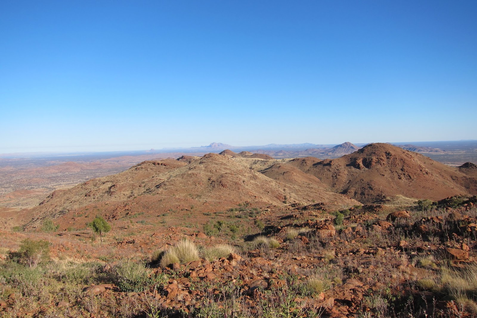
Once we have climbed high enough,
the scenery down to the plain below is fantastic.
I've not seen anything like it,
at least not around Sydney where I live.
At the summit
4 hrs 45 mins later, we reach the summit.
We can see the other major mountains
around Mt Zeil.
To the west is:
- Haast Bluff
- Mt William
- Mt Edward
Mt Edward is the 2nd highest mountain in NT.
It is in aborigines land (native Australians).
Since I'm in this area,
I had sought permission to climb it.
But it was denied 😭
To the south is Mt Razorback,
5th highest mountain in NT
We'll be climbing it 3 days later.
Photos and trip report are in this link:
http://mntviews.blogspot.com.au/2012/07/razorback-nt-australia.html .
To the south-east is Mt Sonder,
4th highest mountain in NT.
We intend to climb it 2 days later.
Unfortunately both my feet had blisters
on the day and I had to cancel the climb.
(PS: Climbed Mt Sonder 3 years later
in July 2015.
Photos and trip report are in this link:
http://mntviews.blogspot.com.au/2015/07/mt-sonder-nt-australia.html .)
Of the highest peaks in all
8 Australian States/Territories,
I have now climbed 6 of them.
Only Mt Meharry, WA (plan - early 2012 Aug)
and Mt Woodroffe, SA (plan - 2013 May)
to complete.
Apart from Tasmania's Mt Ossa
which requires a 2-day hike,
all other "State-8" highest peaks are 1-day hikes.
Mt Zeil is probably the more difficult one
because of the aforementioned loose stones
all over the mountain.
Timeline & Distance
06:15 Start walking from our camp site.
11:00 10.5 km later, reach the summit
----- 50 min lunch
11:50 Leave summit
15:15 10.5 km later, reach our camp site
----- Total 9 hrs, 21 km
Pictures - the day before
We landed at Alice Springs airport at midday.
Hired a 4-wheel-drive car.
Picked up groceries from a supermarket.
Then off on our climbing adventure.
1) Arrived at Dashwood Crossing Bore.
- Here, we leave the 4-wheel-drive trail and
drive off-road towards the dry Dashwood Creek.
- The mountain range in front is Mt Zeil.
- The bore is in the fenced structure
on the right side of this pic.

After crossing the Dashwood Creek,
we follow a faint 4-wheel-drive track
in a general south-east direction
until we reach a line of scrubs
which can be seen in the photo below.
By the way ...
It takes about two and a half hours
to reach here from Alice Springs.
2) This is where we set up camp for the night.
- There is no water anywhere around.
- If you intend to camp around here as well,
make sure you bring all the water you need
with you from Alice Springs.

3) Glad that Jeremy gets a fire going
for our dinner.
- Because, at night, temperature in the
semi-desert environment is 0 celsius.
- I'm on the left.
- Jeremy is on the right.

The fun starts - To Mt Zeil
4) Early morning of the next day.
- Next 3 photos illustrate the effect of the sun
on the colour of the landscape.
- Here the sun is not yet up.
- The distant mountain in the centre
of this pic is Mt Heuglin.

5) Almost the same scene as the previous pic.
- The sun just poked its head above the horizon.

6) Again, almost the same scene.
- The sun is still on the horizon,
but slightly higher now.

7) There is no trail to the summit.
- The ubiquitous spinifex grass look benign.
But they are really atrocious.
They have sharp spikes at the end
which pierce my gaiters, break off,
and lodge the needle-like spines in my legs.

8) Gingerly negotiating my way
through the spinifex grass.

9) Typical terrain and the spinifex grass.

10) Ricky finds the shed skin of a snake.

11) The higher you climb, the better the scenery.

12) Same scene as before ...
But we are now further up the slope.

13) In the middle of this pic and on the horizon
is Mt Edward, 2nd highest mountain in NT.
- It is in Aboriginese land (native Australians).
- I had sought permission to climb it
and was denied without any reason.
When I pressed for a review of the decision,
a curt reply was that the mountain is sacred.
One gets a feeling they made up the "sacred"
business to deny us from climbing it 😭

14) Mt Heuglin is the distant mountain
in the top right quadrant.
- Lovely scenery 😊

15) We are further up the slope now.
- Mt Edward is the distant mountain
on the horizon.
For a long time we couldn't see Mt Zeil's peak ...
16) ... But now, it is in sight.
It is the highest peak in this pic.

17) Traversing a rock face.
- Make sure you don't slip !

18) Strange looking plant with
a black chubby trunk.
- Are they Macrozamia macdonnellii
(Macdonnell Ranges Cycads) ???
- A fire swept through Mt Zeil 9 months ago.
Wonder whether the black trunk is
a result of the fire?

19) Flower of an acacia sapling.
- We do not notice any flower on the mountain,
except this one.

20) If you enlarge the photo below,
you'll see a faint straight line
down the middle of the pic.
- It is a fence; and a service dirt road along side.
- A guy climbed Mt Zeil by cycling
as far as he can along the fence,
then start hiking from there.
- An article about his adventure was in
http://www.themercury.com.au/article/2009/08/26/93491_indepth-8in8in8.html
Unfortunately that page is now defunct 😭

We climb up the mountain
from the north-west side.
From what I can gathered from the internet,
ours is an easier route than
the one mentioned above.
Mt Zeil - Almost there
21) Mt Zeil is the higher peak on the left.
- Almost there

22) Almost there.

23) The last steep climb
- After almost 4 hrs 45 mins of climbing.

Mt Zeil summit
24) Made it !!! What an exhilarating feeling !!!

6 down, 2 to go !!!
Of the highest mountains in each of the
8 Australian States/Territories,
Ricky and I only have
- Mt Woodroff in SA
- Mt Meharry in WA
to conquer.
25) Group photo of the 3 of us.
- Jeremy, Paul, Ricky

Log book at the Zeil summit
26) There is a red log book in a green steel box
at the summit.
- Jeremy is about to open the log book.

27) We added our entry to the log book.
- Jeremy is also "6 down 2 to go".
He only has to bag
Woodroffe (SA) and Bartle Frere (Qld).

28) Entries in the previous 2 pages.
Hardly anyone comes here.
- Note: First entry on the right-hand page ...
A guy called Edward Connellan helicoptered in.
Now, why didn't we think of this 😊😊😊
"2012-01-15 Edward Connellan proposed to
Sonya Lokhanova on top of Mt Zeil today.
Brought her in a helicopter to better my odds"
💗 That is so sweet !

Scenery from Mt Zeil summit
29) Mt Sonder is the distant mountain
on the horizon in the middle of this pic.

30) (Continuation to the right of previous pic)
- The distant mountain range in the right half
of the pic is Mt Razorback.
- Ricky and I will be climbing it a few days later.
See my trip report in
http://mntviews.blogspot.com.au/2012/07/razorback-nt-australia.html

Climbing Mt Razorback will be one the
most interesting trip I've ever done.
Also, as far as I can find, there is hardly any
public information on Razorback anywhere.
When I write a trip report on it later,
it may be the first detailed recorded account
of the ascent on the web.
31) Wonderful scenery of the folding
of mountains from the summit !

360 panorama
A video of the 360 panorama
from the summit of Mt Zeil is in:
http://www.youtube.com/watch?v=ZOVzwPQPRsk
State-8 Peaks
I've now climbed 6 of the highest peaks
in our 8 Australian States/Territories ...
called State-8 peaks.
Links to the other 5 mountains are:
- 2010 Oct, Qld - Mt Bartle Frere
http://mntviews.blogspot.com.au/2010/08/bartle-frere-queensland-australia.html
- 2011 Jan, ACT - Bimberi Peak
http://mntviews.blogspot.com.au/2011/01/bimberi-act-australia-east-approach.html
- 2011 Feb, Tas - Mt Ossa
http://mntviews.blogspot.com.au/2011/02/ossa-tas-australia.html
- 2011 Mar, Vic - Mt Bogong
http://mntviews.blogspot.com.au/2011/03/bogong-vic-australia-west-peak.html
- 2011 Apr, NSW - Mt Kosciuszko
http://mntviews.blogspot.com.au/2011/04/kosciuszo-muellers-peak-townsend-nsw.html
Post script !!!
- 2012 Aug, climbed Mt Meharry in WA
http://mntviews.blogspot.com.au/2012/08/meharry-wa-australia.html
- 2013 May, climbed Mt Woodroffe in SA
http://mntviews.blogspot.com.au/2013/05/woodroffe-sa-australia.html
This completes my mission of climbing
all the State-8 peaks !!!
This comment has been removed by the author.
ReplyDeleteAppreciate this blog ppost
ReplyDelete