2016 May: Day-trip to:
Rigby Hill
via Victoria Falls
and Pierces Pass Walking Track
NSW Blue Mountains, Australia
Prolog
This trip is organised by FB of Sydney Bush Walkers Club.
6 of us:
- FB leads.
- The other 5 are: AB, HM, JR, NP and me
Destination is Rigby Hill ... via Victoria Falls and Pierces Pass Walking Track.
Not much water at Victoria Falls as it hasn't rained for a while. But you can go between the waterfall and the cliff behind it (photos #15 and #16), so that is exciting.
Rigby Hill (923 meters in elevation) has a marvelous view of Grose Valley and the escarpments around it ... well worth a visit.
Rigby Hill for masochists
It is easy to climb Rigby Hill. Drive on Bells line of Road, then turn south into an unsealed access road called Pierces Pass Road. One kilometer later, you'll be at a carpark and picnic area. Park the car and after 15 minutes of walk, you'll be at the top of Rigby Hill.
But FB leads us on a long trek ... walk to there from the end of Victoria Falls Road near the township of Mt Victoria. It is around 500 meters in elevation down to Grose River, then a similar amount up Pierces Pass to the top of Rigby Hill - 4 hours one-way. And we have to repeat the yo-yo on the return trip !
Compare it to 15 minutes to the top of Rigby Hill if one comes from Bells Line of Road ... we bushwalkers are a bunch of masochists. But it is good exercise for those who wish to burn up calories to lose weight !
Maps
- 1:25,000 scaled Mount Wilson 8930-1N
- 1:50,000 scaled Blue Mountains North by Spatial Visions Innovation, 1st edition
- 1:100,000 scaled Katoomba 8930
Here is the 1:25,000 scaled map of the relevant part of today's walk. (Click on the map to enlarge it.)

GPS tracklog files & Route
Our GPX tracklog files can be downloaded from:
- Carpark & picnic area at end of Victoria Falls Rd to Rigby Hill
https://drive.google.com/file/d/0B877-h5SCJaSQmhjNWw5NmI4RlE/view?usp=sharing
- Return leg: Rigby Hill to carpark & picnic area at the end of Victoria Falls Rd
https://drive.google.com/file/d/0B877-h5SCJaSdWl5X1BmVE1jY3M/view?usp=sharing
Our tracklog, thin red line, superimposed on the 1:25,000 scaled map. (Click on the map to enlarge it.)

Satellite image (Click on the image to enlarge it.)

A summary of our route is:
- Start from carpark & picnic area at end of Victoria Falls Rd near the township of Mt Victoria in the Blue Mountains.
- To Victoria Falls Lookout
- To Victoria Falls
- To Burra Korain Flat camping area
- Walk on a track along Grose River towards Pierces Pass Walking Track
- Climb up Pierces Pass Walking Track to Rigby Hill trailhead at Pierces Pass carpark & picnic area
- Climb up Rigby Hill ... which is today's objective
- Retrace steps all the way back to carpark & picnic area at end of Victoria Falls Rd
Timeline & Distance
08:26 0.0 km Start walking from carpark & picnic area at end of Victoria Falls Rd
08:28 0.1 km At Victoria Falls Lookout
08:29 0.1 km Start walking down Victoria Falls Track
09:02 1.8 km At cascade above Victoria Falls
09:06 1.9 km Resume walking
09:09 2.0 km At top of Victoria Falls
09:12 2.0 km Resume walking
09:18 2.4 km At bottom of Victoria Falls
Explore around the fall
09:27 2.5 km Start walking down Victoria Creek
09:52 3.8 km At Burra Korain Flat camping area
1st Morning Tea
10:00 3.9 km Resume walking
10:04 4.0 km At junction of Victoria Creek & Grose River
11:14 8.0 km At junction of Grose River & Pierces Pass Walking Track
2nd Morning Tea
11:19 8.0 km Start walking up Pierces Pass Walking Track
12:08 10.4 km At a carpark & picnic area, which is also the trailhead to Rigby Hill
Wait for FB and AB
12:18 10.4 km Start climbing up Rigby Hill
12:31 11.0 km At Rigby Hill summit
Lunch
13:09 11.1 km Leave Rigby Hill summit
13:29 11.7 km At carpark & picnic area, which is also the trailhead to Rigby Hill
Toilet break
13:33 11.7 km Starting walking down Pierces Pass Walking Track
14:16 14.3 km At junction of Pierces Pass Walking Track & Grose River
Wait for FB
14:23 14.3 km Start walking up Grose River
15:34 18.2 km At junction of Grose River & Victoria Creek
Afternoon Tea
15:49 18.2 km Start walking up Victoria Creek
16:55 21.5 km At Victoria Falls Lookout
16:58 21.5 km Resume Walling
17:01 21.6 km At carpark & picnic area at end of Victoria Falls Rd
==============================================
Total: 8 hrs 35 mins
21.6 km Distance is from Google Earth
23.6 km Distance is from Garmin GPS
Pictures - Carpark & picnic area at end of Victoria Falls Road
1) This is where we start walking - at the end of Victoria Falls Road.
- Grose Valley Lookout is also known as Victoria Falls Lookout
- On our way to Rigby Hill, we'll pass Victoria Falls and Burra Korain Camping Area.

Victoria Falls Lookout
2) At Victoria Falls Lookout which is 150 meters from the carpark ... still early morning, misty ~~~
- Left red arrow points to Asgard Head.
- Right red arrow points to Burra Korain Head.
- Burra Korain Ridge is to the right of Burra Korain Head.
- The valley between the two red arrows is where Victoria Creek flows.
- From the lookout, we'll descend down to the creek and follow the yellow arrows.
- The horizontal yellow arrow is where Grose River flows in Grose Gorge aka Grose Valley.

to Burra Korain Head;
then cross Crayfish Creek;
then to Hanging Rock at Burramoko Head.
It'll be an exciting trip, well worth doing ! Photos and trip report are in my blog:
http://mntviews.blogspot.com/2018/09/burra-korain-head-to-hanging-rock.html
Victoria Falls Track
3) We are walking down Victoria Falls Track to Victoria Falls.
This pic is looking back at the steps ... only some of the steeper sections of the track has steps like this.

4) Passing by these cliffs
(These pics are looking back at the track.)

5) Not far from where the previous photo was taken ~~~
The people in the photo are from our group - JR is directly in front of me.

6) Some parts of the track are steep, like here, and no steps.
From left to right: HM NP AB JR

7) Escarpment on the west side of Burra Korain Ridge ~~~
- Left & right side photos are continuation to the left/right of each other.
- Upper photos are taken in the morning; lower photos are taken in the afternoon when the sun is shining on the cliffs; hence the colour difference.

8) Still walking down Victoria Falls Track ~~~
Left to right: AB JR NP HM FB

Cascade above Victoria Falls
9) A short detour from the track to a cascade above Victoria Falls

Top of Victoria Falls
10) Another short detour towards this edge which is the top of Victoria Falls ~~~
It hasn't rained for a while, the place is quite dry.
- People in the photo: AB (nearest to the camera), JR, NP, HM, FB

11) At the edge of the previous photo

12) At the same spot as photo #10 was taken ~~~
We are returning to Victoria Falls Track.

13) Now back on Victoria Falls Track and looking at the top of Victoria Falls ~~~
- The red oval is the edge where we were standing in photo #11.
- By the way, this is not the main fall. The main fall is in photo #14.

Victoria Falls - the main fall
14) Now at the main fall of Victoria Falls ~~~
Not much water ... It hasn't rained for a while.

15) NP leading the way to go behind the waterfall

16) Behind the waterfall and looking down at HM JR NP FB

To Burra Korain Flat camping area
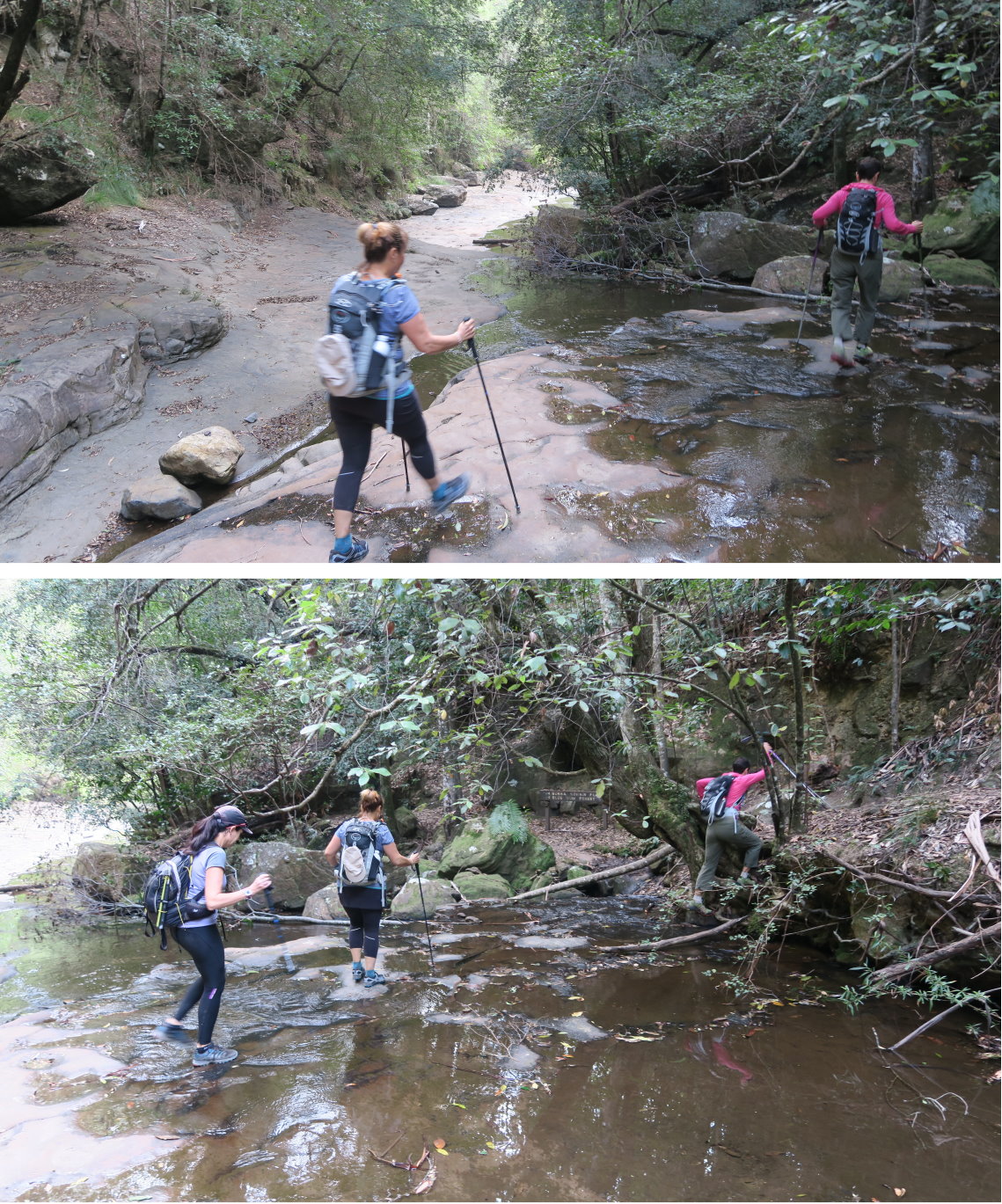
17) We've left Victoria Falls, now crossing Victoria Creek at a short distance down stream from the fall.

18) Same spot as the previous pic - HM FB NP crossing Victoria Creek
19) Cascade and pool not far down stream of Victoria Falls.

20) Vines

21) On the track to Burra Korain Flat camping area ~~~
AB is in front of me. In front of her is HM.

22) Looking back ~~~
FB is leading, followed by AB.

Burra Korain Flat camping area
23) At Burra Korain Flat Camping Area which is near the junction of Victoria Creek and Grose River ~~~
We have morning tea here ... but no, we didn't set up this camp site, nor light a fire :-)

Junction of Victoria Creek and Grose River
Not far down stream from the camping area is the junction of Victoria Creek and Grose River.
24) We are now at the junction. This photo is looking back at Victoria Creek.

25) Still at the junction of Victoria Creek and Grose River ~~~
NP is leading the charge down Grose River.

26) Same scene as above - but this pic is taken in the afternoon when we are on the return leg, with the late afternoon sun shining on the distant cliffs.

Along Grose River
27) For the next 4 km (1 hr 15 min), we follow the course of the Grose River. Occasionally we walk by the side the River.

28) But most of the time, we are on a track on the slope above the river. Here, the river is on the left edge of this photograph.
- Left to right: AB HM FB JR NP

Crossing Gross River
(At junction of Grose River and Pierces Pass Walking Track)
We now come to the junction of Grose River and Pierces Pass Walking Track which is also known as Hungerfords Track.
29) Crossing Grose River (so as to get to Pieres Pass Walking Track) ~~~
In the pics, NP is leading, followed by FB & AB. HM is at the rear.

30) NP (upper pic) and FB (lower pic) in action !

31) Still crossing the Grose River ~~~
I am standing in the middle of the river looking up stream.

32) This photo is zooming onto the lower part of the previous pic.

We have a rest here by the Grose River, call it 2nd morning tea, before the steep climb up Pierces Pass Walking Track to Rigby Hill.
Pierces Pass Walking Track
33) Rest is over; start the steep climb up :-) Here, FB is in action.
Some parts of the track is like this photo ...

34) ... But most of the time, the track is like this. (It is still steep, though this photo doesn't quite show it.)

35) Looking south-west-ish across Grose Valley at Blackheath Walls - the cliffs on the other side of Grose River

36) Mushrooms found on the track

37) Cliffs on the northern side of Grose River and to the south-east of Rigby Hill

38) Rigby Hill, our destination, is at the top of this cliff.
We won't be climbing directly up. Instead, we'll walk north, up Pierces Ravine, which is on the left side of the cliff. When we reach a carpark and picnic area, we'll turn south to climb Rigby Hill from behind the cliffs.

39) We are at the mouth of Pierces Ravine and looking at the cliffs forming the west part of Rigby Hill.

40) At roughly the same place where the previous photo was taken and looking in the opposite direction, across the mouth of Pieces Ravine at:
- The rock cliff on the left: Liversidge Hill
- The rock cliff on the right: Southern tip of Yileen Spur
- Pierces Ravine

41) Now walking in a northerly direction up Pierces Ravine towards a carpark and picnic area.
We are not anywhere near the floor of the ravine. We are quite high up on the slope on the west side of Rigby Hill.

Pierces Pass carpark and picnic area
We reach the carpark and picnic area.
Instead of walking for 3 hours and 42 minutes, you can simply drive to here from Bells Line of Road :-) The access road from the turn off at Bells Line of Road is called Pierces Pass Road. It is about 1 km drive from the turn off to here.
42) Near the carpark and picnic area are pagoda-like rock formations.
It would be interesting to explore these pagodas. But we go on to climb Rigby Hill instead.

43) Still at the carpark and picnic area ... This photo is the trailhead to Rigby Hill,

To Rigby Hill
44) Now walking south to Rigby Hill

45) Scenery towards the east just before the final climb up the slope of Rigby Hill ~~~
- The yellows arrows mark the Walls Lookout Walking Track. I'll walk on it 2 months later in 2016-07. Photos and trip report are in my blog: http://mntviews.blogspot.com.au/2016/07/walls-lookout-blue-mts-botanic-garden.html

46) Final ascend to Rigby Hill

Rigby Hill
47) This is the top of Rigby Hill, a small patch of flat area, 923 meters high.

48) From the edge of the cliff is a panoramic view of Grose Valley and its cliffs at their sparkling best !
- The valley is where Grose River flows.
- The left red arrow points to Frank Hurley Head.
- Banks Wall is the cliff to the immediate left of Frank Hurley Head.
- Walford Wall is the cliff under the red horizontal bar.
- The right arrow points to Perrys Lookdown.
- Blackheath Wall is the cliff to the right of Perrys Lookdown.

49) Continuation to the right of the previous pic ~~~
- The 4 red arrows point to, from left to right:
1 Bald Head
2 Burramoko Head
3 Burra Korain Head
4 Liversidge Hill
- The red oval is Yileen Spur which forms the west side of Pierces Ravine.
- Behind Burra Korain Head is Victoria Creek.
- The main valley across this pic is where Grose River flows.
- We came here from Victoria Creek, then walk on a track (the yellow arrows) that follows the course of Grose River.

to Burra Korain Head;
then cross Crayfish Creek;
then to Hanging Rock at Burramoko Head.
It'll be an exciting trip, well worth doing ! Photos and trip report are in my blog:
http://mntviews.blogspot.com/2018/09/burra-korain-head-to-hanging-rock.html
50) Group photo: Left to right - JR, NP, me/AB, HM, FB
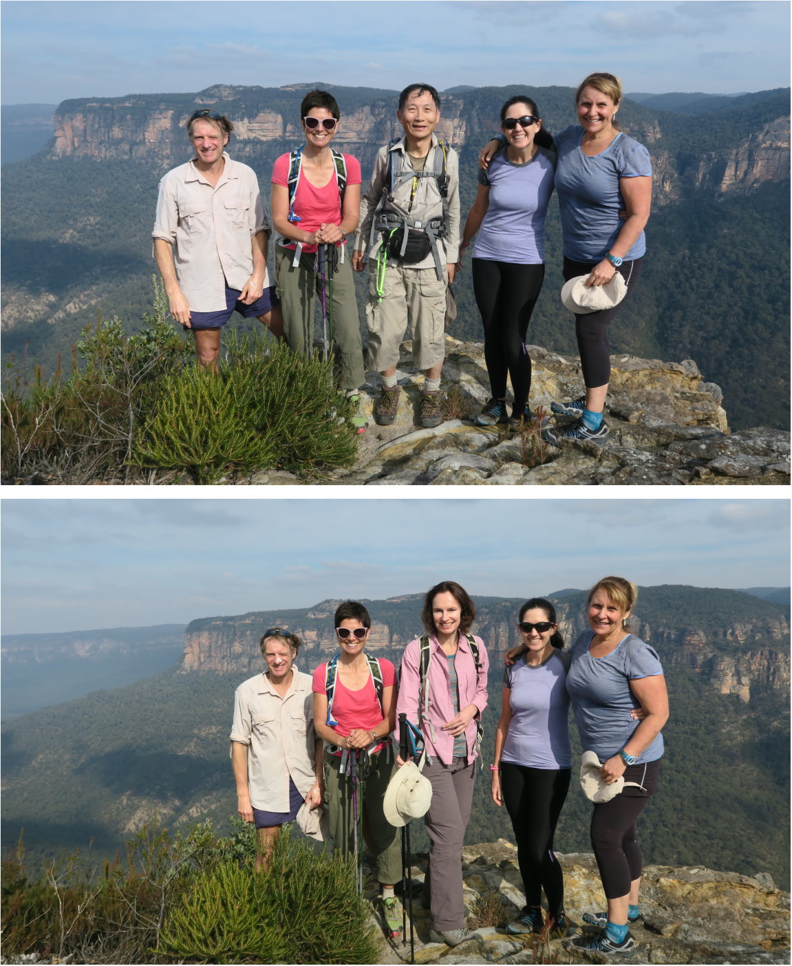
51) We have lunch here.
- Left to right: FB NP HM JR
- The prominent hill in the middle of the pic is Liversidge Hill.

52) Heart shape sweat on AB's t-shirt :-)

Climb down Rigby Hill
Lunch is over, time to retrace our steps all the way back to our cars.
53) Climbing down Rigby Hill.
- The red arrow on the left points to Pierces Ravine. We came up from there.
- The red circle is the carpark and picnic area (photos #42 and #43) which can be reached by car from Bells Line of Road.
- The 3 yellow arrows on the left side of the pic show how we came up from Pierces Ravine to climb up Rigby Hill.
- The lone yellow arrow on the right is the Walls Lookout Walking Track. I'll walk on it 2 months later in 2016-07. Photos and trip report are in my blog: http://mntviews.blogspot.com.au/2016/07/walls-lookout-blue-mts-botanic-garden.html

Down Pierces Pass to Grose River
54) On the way down Pierces Pass Walking Track, we meet this couple. Note the woman is walking bare-footed, holding the shoes in her hand. She says they are wet. But still, I prefer to walk with wet shoes than bare-footed :-)
The guy is carrying 2 babies ... hhmmm he is game as the track is quite rough, easy to trip and take a tumble.

Junction of Pierces Pass Walking Track and Grose River
55) Now back at the junction of Pierces Pass Walking Track and Grose River - the same spot as in photo #29

56) At the same place as the previous pic - FB gingerly crossing the boulders over Grose River.

On the track along Grose River
57) This is a popular track for hikers ... we meet plenty of groups on our return trip.
NP is near the lower right hand corner.

58) Escarpment south-east of Burra Korain Head ... I think ... assuming my camera is pointing north-west.

59) Orange-coloured Banksia are in full bloom and are everywhere.

Junction of Grose River and Victoria Creek
60) We are now back at the junction of Grose River and Victoria Creek - this is the same place where photos #25 and #26 were taken.

61) Taking afternoon tea at the junction of the two waterways

To Victoria Falls Lookout
It is a steep climb up Victoria Creek to our cars ... when we are all tired ! Today's trip is perfect for those who wish to burn up calories to lose weight :-)
Victoria Falls Lookout
62) Back at Victoria Falls Lookout again
(The 2 guys here don't belong to our group.)

63) Still at Victoria Falls Lookout ~~~
- Left red arrow points to Asgard Head.
- Right red arrow points to Burra Korain Head;.
- Burra Korain Ridge is to the right of Burra Korain Head.
- The valley between the two red arrows is where Victoria Creek flows.
- This morning, we descended down to the creek and follow the yellow arrows towards Pierces Pass. The horizontal yellow arrow is where Grose River flows in the Grose Valley.
- Sunset is at 5:03pm. Time now is 4:55pm ... It will be dark soon. (Compare this pic with photo #2 which was taken in the early morning.)

64) We linger around Victoria Falls Lookout for the sun to set and snap this lovely picture of the moon 20 minutes after sunset.

No comments:
Post a Comment