2016 June: Day walk - Cape Horn, Lawler Point & Lawler Caves from the south, Wolgan State Forest, NSW, Australia
Wolgan State Forest & Cape Horn
About Wolgan State Forest:
- It is east of Ben Bullen State Forest
- South of Gardens of Stone National Park
- West of Wolgan Road
About Cape Horn:
- The Cape Horn plateau is a small plateau in Wolgan State Forest. It juts out eastward from the Great Dividing Range in the Wolgan area.
- On the map, Cape Horn refers to a lookout at the eastern tip of the plateau.
- Wolgan Road runs between Cape Horn and Donkey Mountain.
Today's trip - to Cape Horn area from the south
This is a rare opportunity to explore the Cape Horn area from the south, from Bill Lawler's property which adjoins Wolgan State Forest.
The 3 main places of interest we'll be visiting are:
- Lawler Point: Highest point on the Cape Horn plateau, about 1020 meters in elevation ... name is given by Bill Lawler.
- Cape Horn lookout: Eastern tip on the Cape Horn plateau
- Lawler Cave 2: A large overhang with light-coloured cliff faces
Why "2" in the name "Lawler Cave 2"? Because Bill Lawler has explored extensively in the Cape Horn area ... well, it is in his backyard :-) And he has named a host of features in this area, including names like "Lawler Cave 1", "Lawler Cave 2", Lawler Cave 3", ..., etc :-)
Our party of 12 is led by Bill:
- Bill Lawler, leader
- Michael Keats
- Brian Fox
- Yuri Bolotin
- Geoff Fox
- Kate Girdwood
- ZL, Bill's son
- JA
- GA
- JF
- JP
- Paul, me
Michael, Brian, Yuri, Geoff and Kate are the heavy weights in the NSW bushwalking community. I'm glad to be in the company of these illustrious giants.
Cape Horn area from the west
5 months later, in 2016-11, I re-visited the Cape Horn area, this time from the west. Photos and trip report are in my blog:
http://mntviews.blogspot.com.au/2016/11/cape-horn-lawler-point-wolgan-state.html
Maps
- 1:25,000 scaled 8931-4S Ben Bullen and 8931-3N Cullen Bullen
- 1:100,000 scaled 8931 Wallerawang
Here is the 1:25,000 scaled map of the relevant part of today's walk.

GPS tracklog files & Route
Our GPX tracklog files can be downloaded from:
- The walk:
https://drive.google.com/file/d/0B877-h5SCJaSZElyQWhyaWtyNVE/view?usp=sharing
- The drive on the access road to a shed in Bill Lawler's property: (We park the cars and start the walk from the shed.)
https://drive.google.com/file/d/0B877-h5SCJaSeGZqckJlWktCZ0U/view?usp=sharing
Our tracklog, red colour, anti-clockwise direction, superimposed on the 1:25,000 scaled map.
The starting point of our walk is at the bottom tip of the tracklog.
Scroll forward to the satellite photo for more information on the places we'll visit today.

Satellite view of the tracklog, red colour, anti-clockwise direction: (Click on the image to enlarge it.)
The starting point of our walk is at the bottom tip of the tracklog.
The yellow circle is the saddle (between Cape Horn plateau on the right, and the cliffs on the left)
The yellow arrows point to, from left to right:
- Lawler Cave 2
- Lawler Cave 1
- Exposed orange-coloured ledge
- chain
- Lawler Point
- lookout on top of a pagoda-like rock formation
- Cape Horn

A summary of our route is:
- Start from a shed in Bill Lawler's property, bottom tip of the above tracklog
- To the saddle, yellow circle
- To Lawler Point
- To Cape Horn, right-most tip of the tracklog
- To lookout on top of a pagoda-like rock formation between Cape Horn and Lawler Point
- Back at the saddle
- Visit the chain
- Walk west to an exposed orange-coloured ledge
- Return to the saddle
- To Lawler Cave 1
- To Lawler Cave 2, left-most tip of the tracklog
- Return to the shed in Bill Lawler's property
Timeline & Distance
09:07 0.0 km Start from a shed in Bill Lawler's property
10:06 2.2 km At the saddle
10:11 2.2 km Resume walking
10:18 2.4 km At top of Lawler Point
10:25 2.4 km Leave top of Lawler Point
10:27 2.5 km At base of Lawler Point ... so as to get out of the wind for morning tea
Morning Tea
10:40 2.5 km Resume walking
10:58 3.4 km At Cape Horn
11:04 3.4 km Leave Cape Horn
11:11 3.8 km At a pagoda lookout halfway between Cape Horn & Lawler Point
11:14 3.8 km Leave lookout
11:48 4.6 km At the saddle, same spot as at 10:06
11:53 4.7 km At chain
11:58 4.7 km Leave chain
12:21 5.2 km At an exposed orange-coloured ledge
12:22 5.2 km Turn around
12:30 5.5 km Stop for lunch
Lunch
12:48 5.5 km Resume walking
12:57 5.8 km At the saddle, same spot as at 10:06 and 11:48
14:03 7.2 km At Lawler Cave 1, a dark cave due to too many trees around and not enough sunlight
14:13 7.2 km Leave Lawler Cave 1
14:22 7.3 km At Lawler Cave 2, a large overhang with light-coloured cliffs
14:32 7.4 km Leave Lawler Cave 2
15:33 9.8 km End at shed in Bill Lawler's property
==============================================
Total: 6 hrs 26 mins
9.8 km Distance is from Google Earth
11.7 km Distance is from Garmin GPS
Pictures - Start at Bill Lawler's property
1) We parked our cars here, by the side of a shed in Bill Lawler's propery. And we are just about to start walking.
Left to right:
JP, JA,
Bill Lawler, Yuri Bolotin, Michael Keats,
Geoff Fox, Brian Fox, Kate Girdwood

To saddle
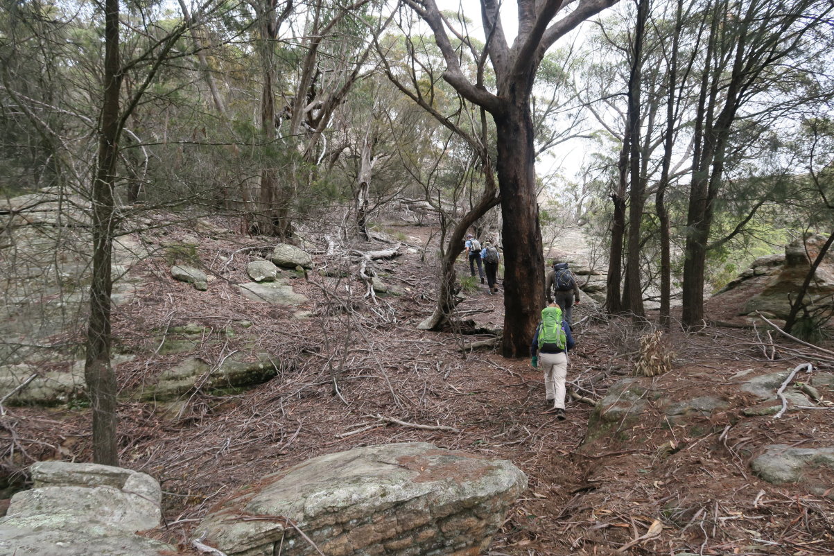
2) 15 minutes, 550 meters after we started, we take a brief stop to survey the scene in front. Almost every one is in this pic ... Left to right:
Geoff Fox,
JP,
Yuri Bolotin, Kate Girdwood, Brian Fox,
Bill Lawler, ZL, JF,
GA, JA
(Not in the pic: Michael Keats; plus me taking this photo)

3) This is what we are looking at: Two of our main interests ... Lawler Point (left red arrow) and Cape Horn (right red arrow) ... Click on the pic to enlarge it.
- First, we climb up the vertical yellow arrow to the saddle.
- Then climb Lawler Point, left red arrow.
- Then to Cape Horn on the east, right red arrow.
- Then double back to the saddle, and traverse westward (towards the left) along an upper ledge (double-sided yellow arrow) to the blue arrow.
- Just to the right of the tip of the blue arrow is an exposed ledge. In the pic, it shows up with an orange tinge ... see photos #49 and #52. Some members of our party cross it. A few are reluctant to do so. Hence this exposed ledge is as far west (left) as we'll go in the morning.
- Then double back along the yellow arrow to the saddle.
- Drop a little bit lower and traverse along a lower ledge, the pink arrows, towards the west (left).
Also see photos #4 and #5.

4) Google Earth View of our route in turquoise colour ...
From left to right, the 4 arrows point to:
- Blue arrow: Lawler Cave 2, a large light-coloured overhang/cave.
- Blue arrow: Exposed orange-coloured ledge, this is as far left (west) as we go along an upper ledge in the morning.
- Red arrow: Lawler Point
- Red arrow: Cape Horn
(These arrows point to the same places as the ones in photos #3 and #5.)

5) Worth another look at the scene again ... Click on the pic to enlarge it.
- We'll descend the cliff along the left-most pink arrow. In fact, the start of this arrow is Lawler Cave 2.
- For commentaries on the rest of the arrows, see photos #3 and #4.

6) Crossing from Bill Lawler's property into Wolgan State Forest.
- JP is the guy on the ground crawling under the barbed fence.
- Michael Keats is holing up the barbed wire.
- Behind Michael Keats is Geoff Fox holding a camera and taking photos.
- ZL is watching on the right.
- JF is the guy closest to the camera.

7) We find a thingie on the ground.
Bill Lawler is explaining it was probably something used by foresters in the 1950s. Exactly what is a mystery.
The others in the pic watching are, from left to right: GA, Brian Fox, Yuri Bolotin, Michael Keats

8) We are climbing towards the saddle.
Kate Girdwood is at the front.
At the lower part of the slope, there is hardly an vegetation on the ground ...

9) ... But higher up the slope, there is more greenery.

At the saddle
10) We reach the saddle west of Lawler Point.
Left to right: JF, Bill Lawler, JA, Kate Girdwood

11) - The upper pic is a rock on the west side of the saddle (left side of the previous pic).
- The lower pic is a rock on the east side (right side of the previous pic). Lawler Point can't be seen from here, but it is not too far behind this rock.
People in the lower photo: Brian Fox & JA

12) The termite mound that you can see in the previous pic

To Lawler Point
13) Now walking to Lawler Point ~~~
JA with her green backpack is in front of me.
14) Not far to Lawler point ... it is right on the left edge of this pic.
From left to right: Bill Lawler, Brian Fox, ZL, JA

15) Lawler Point is just in front.
From left to right: JA, ZL, JF, Brian Fox, Bill Lawler

Lawler Point
16) Climbing up Lawler Point ~~~
In the upper pic:
- Brian Fox & Bill Lawler are near the top.
- JF is midway up.
- JA & ZL are near the bottom.

17) This is it, the top of Lawler Point, about 1020 meters in elevation.
Left to right: Brian Fox, JF, ZL

18) Being the highest point on the Cape Horn plateau, Lawler Point has a fantastic 360-degree view of the surrounding country side. This view is from west to north-east.
- Barton Creek flows in the clearing on the right side of the pic.
- On the left side of the pic, the saddle is between here at Lawler Point and the cliffs on the other side.
- It is not necessary to climb Lawler Point and Cape Horn from Bill Lawler's property. You can drive on an unsealed road on the other side of the saddle ... the blue dashes indicate where the unsealed road is. (Click on the pic to enlarge it.) Continue beyond the blue dashes, the road ends at the edge of the cliff, near the top of the bright yellow square near the centre of the pic. From there it is possible to climb down the cliffs and climb up to here at Lawler Point. I'll do just that 5 months later in 2016-11. A trip report will be written up soon ... whatever soon means :-)

19) Continuation to the right of previous pic ~~~
This view is from north-east to south-east.
Barton Creek flows in the valley on the left side of the pic.
The 2 ovals are, from left to right:
- Donkey Mountain
- Cape Horn, due east ... and this is where we are going next.

20) Continuation to the right of previous pic and towards south ~~~
Upper pic: Me ! ~~~
- Left red arrow: Wolgan Gap ... Wolgan River & Wolgan Road go through there.
- Right red arrow: Where our cars are parked in Bill Lawler's property.
- Yellow arrow: Where we turned west from Wolgan Road into Bill's property.
Lower pic: Zooming onto centre of the upper pic ~~~
- Red arrow: Where our cars are parked by the side of a shed in Bill Lawler's property. Unfortunately we can't see the cars ... blocked by the tree :-( But you can just see the shed a wee bit to the right of the red arrow.
- Yellow arrows: How we turned west from Wolgan Road and drive along the yellow arrows to the shed.

21) Continuation to the right of previous pic ~~~
This view is from south-west to west:
- The long yellow arrow near the lower right hand half of the pic is how we climb up to the saddle between Lawler Point and the cliffs on the other side of the saddle.
- The double-sided yellow arrow near the centre of the pic is how we will walk to and back hugging along a ledge later on.
- The pink arrows outline how we will return to our cars.
- It is interesting to compare this pic with photo #5 ... however from here at Lawler Point, we can't see the blue arrow in the middle of photo #5.
- Continuation to the right of this pic is photo #18, thus completing a 360-degree panoramic view !

22) Well, can't stay at the so nice Lawler Point forever ... time to leave.
GA and Geoff Fox climbing down ... well, sliding down :-)
While sliding down, a patch of cloth is ripped off from the bum part of GA's trousers :-) Lesson learnt: Always wear sturdy clothes while bushwalking :-)

To Cape Horn
23) Now walking to Cape Horn, passing by some interesting rock formations
Geoff Fox is the guy at the rear.

24) GA finds something yukky ... she is holding a skull of an animal with tissues attached.

Cape Horn
25) Approaching Cape Horn lookout

26) At Cape Horn lookout ~~~
Left to right: Brian Fox, Yuri Bolotin, Bill Lawler

27) The view from Cape Horn is nice, though not the 360-degree panorama as at Lawler Point.
- Red arrow: Towards south, points at Wolgan Gap ... Wolgan River & Wolgan Road go through there.
- Red circle: Bill Lawler's shed and our cars are there ... we can't see them, blocked by the tree.

28) Towards the west is Donkey Mountain (left red oval) and Emirates One&Only Resort (right red oval).

Start to return to the saddle
29) Cape Horn is as far east as we can go. Now we return to the saddle (from where we climbed up to Lawler Point earlier on).
JP is the guy in the pic.

Short detour to a lookout
30) A short detour to this pagoda-like rock formation, halfway between Cape Horn and Lawler Point

31) Climbing up to the pagoda of the previous pic ~~~
It is a nice lookout.
Left to right: GA, Kate Girdwood, JA, ZL, Bill Lawler

32) This is the view from the top of the pagoda:
- Left arrow: Wolgan Gap ... Wolgan River & Wolgan Road go through there.
- Right arrow: Lawler Point, highest point on the Cape Horn plateau ... we climbed to its top not long ago.

33) Zooming onto Lawler Point

Return to saddle along a ledge
34) From the pagoda lookout, instead of retracing steps back to the saddle, we climb down the cliff a bit so as to walk along a ledge ... see photo #35.
- Upper pic, left to right: GA, JA, JF, Geoff Fox, Michael Keats, Kate Girdwood
- Lower pic, left to right: JF, Michael Keats, Kate Girdwood

35) Geoff Fox walking along the ledge

At the saddle
36) Now back at the saddle ~~~
This rock is the same as the one in the lower pic of photo #11 ... Lawler Point is not far behind it.

Chain
37) There is a chain hanging down from the top of this cliff. We are near the left side of the upper pic of photo #11 ... which is the cliff on the western side of the saddle.
- The pic on the right is zooming into the red square of the left pic.
- In the red oval is the chain hanging down from the top of the cliff.
- At the bottom of the left pic is Michael Keats.
- A half-hearted attempting to climb up the chain is Brian Fox.
Even with the assistance of the chain, it will be difficult to climb up due to lack of footholds. So the question is: What is the purpose of the chain doing here? One can climb up/down the cliff by going around and towards the right side of this pic ... not too far away there is a way to scramble up.

Walk along a ledge towards west
From where the chain is, we now head towards an exposed orange-coloured ledge ... the blue arrow in photos #3, #4 and #5.
38) Some photographs of the cliffs along the ledge.

39) Cliffs along the ledge ~~~
Right pic, left to right: Yuri Bolotin, Kate Girdwood, ZL

40) Some of the rock faces are colourful.

41) Kate Girdwood passing by a Banksia completely covered in orange moulds

42) Passing an overhang ~~~
Left to right: Bill Lawler, JA, Yuri Bolotin, ZL, Kate Girdwood
We'll have lunch here later on ... see photo #53.

43) Here, a rock platform juts out from the ledge. Brian Fox and I are at the platform, taking photos of the others who stay put by the side of the cliff.
Left to right:
GA,
JP, JA, (blocked by the tree trunk)
Yuri Bolotin, Kate Girdwood, Bill Lawler, JF, Michael Keats, ZL, Geoff Fox

44) From the platform where I am standing (as described in the previous pic), here is the view: (Click on the pic to enlarge it.)
- The small yellow circle is where we turned west from Wolgan Road into an access road to Bill Lawler's property.
- The red arrow is where our cars are parked.
- The 2 yellow arrows on the left are how we climbed up to the saddle this morning.
- The 3 pink arrows on the right are how we will descend the cliffs back to the cars later in the afternoon.

45) Continuation to the right of the previous panorama ~~~
Interesting cliffs

46) Zooming into the middle of the pic of photo #44.
- The small yellow circle is where we turned west from Wolgan Road into an access road to Bill Lawler's property.
- The red arrow points to where our cars are parked.
- The yellow arrow is how we climbed up to the saddle this morning.
- The pink arrow on the right is how we will descend the cliffs back to our cars later in the afternoon.

47) Anyone knows the name of this grass-like plant?
Around here, there are plenty of them. They have a red tinge near the root.

48) Continuing along the ledge ... Michael Keats is in front of me.

49) We reach an exposed orange-coloured ledge ... it is where the blue arrow is pointing at in photo #3.
Careful ! One slip and you are dead ! :-)
Left to right: JF, JA, Bill Lawler, ZL, Kate Girdwood
Some people stay back and do not go along with us.

50) View from the exposed ledge

51) Once we are over the ledge, this is what we see ... an interesting split in the cliff.
We are now at the tip of the blue arrow in photo #3.
We can't proceed further because some people have stayed behind on the other side of the ledge. But it would be interesting to keep going to see at where it will lead to the top of the cliff. Bill Lawler and Yuri Bolotoin suggest they may organize another trip to do so.

So here, we turn around.
Return to saddle
52) Retracing our steps on the exposed orange-coloured ledge ... this is the same ledge as in photo #49.

53) Lunch is at the same overhang as in photo #42.
We are a bit quiet as it is winter now ... we are cold and we are in the shade :-)
Usually lunches last for half an hour or more. This one is quick, 18 minutes only :-)
Left to right:
- Kate Girdwood
- Michael Keats, with the yellow cap
- Geoff Fox, at the back
- Yuri Bolotin
- Brian Fox
- JF

To Lawler Caves 1 & 2
54) Lunch is over, and we have returned along the double-headed yellow arrow of photos #3 and #5 all the way back to the saddle. There, we dropped down a bit and u-turned towards the Lawler Caves along the pink arrows. Here are the photos along the ledge of the pink arrows.

55) Cliffs along the ledge

56) Approaching a cave ... It is the horizontal dark band across the top half of the pic ... Some of us are already there. Not sure whether Bill Lawler has given a name to this cave.

57) At the above cave ~~~
Left to right: Kate Girdwood, ZL, JA JF

Lawler Cave 1
Between 14:03 and 14:13, at Grid Reference 306 171, we are at another cave named as Lawler Cave 1 by Bill Lawler :-) It is a darker cave due to too many trees around and lack of sunlight. My photos of the area are not particular interesting and won't be shown here. If you have a better photo and like to have it displayed here, contact me.
Lawler Cave 2
58) After Lawler Cave 1, we come to a large overhang with light-coloured, almost white-ish walls ... Bill Lawler is standing at the centre of it. He named it Lawler Cave 2 ... what else do you expect him to name it :-)
Compared to Lawler Cave 1, this one is huge.

59) From where Bill Lawler is standing in the previous pic and looking down at where we came from ~~~
- On the left is Geoff Fox sitting on a rock.
- On the right is JP coming up. Further back is JA, you can just see her green backpack.

60) The light coloured cliffs and the large dimension make this cave stands out as something special. We are impressed.
In the pic, Bill Lawler is in the front.
At the back, from left to right: Kate Girwood, JF, ZL, Brian Fox

61) From left to right:
- Left edge: JF, ZL, Bill Lawler
- Far away: Brian Fox
- Near bottom of the pic: GA, Geoff Fox taking photos, JA, Michael Keats
The red oval is the cliff in the middle of photo #63.

62) Still at Lawler Cave 2 ~~~
Compared to previous photos, this pic is looking in the opposite direction.
Note the colour difference. The cliffs are browner in this direction.

Even though this is a nice place, we can't stay here forever. Time to bushbash back to our cars.
Return to our cars
63) Less than 5 minutes after we descended Lawler Cave 2, and looking back at where we have been ~~~
The red arrow points to the exposed ledge in photos #49 and #52.

64) We are back in Bill Lawler's property. This is his dam.

65) Walking back to our cars ~~~
Left to right:
Bill Lawler, Brian Fox, Yuri Bolotin, JF, Kate Girdwood,
(tree)
Michael Keats, ZL, JA

66) Back at Bill Lawler's property ~~~
A final look at where we have been ... The 3 red arrows point to, from left to right:
- Lawler Point, blocked by the tree
- Cape Horn
- Donkey Mountain ... I have been there on 2 earlier occasions, and will be there again 2 months later in 2016-08.
In the pic, Geoff Fox is the guy taking photos.

67) Zooming onto Donkey Mountain which is to the right of the perfectly conical-shaped mountain at the centre of the pic
(The conical-shaped mountain is west of Donkey Mountain and is not named in all maps.)

• 2016-08 East side with Geoff Fox: http://mntviews.blogspot.com.au/2016/08/donkey-mountain-north-east-maze-gardens.html
• 2016-03 East side: http://mntviews.blogspot.com.au/2016/03/donkey-mountain-north-east-maze-gardens.html
• 2016-01 West side: http://mntviews.blogspot.com.au/2016/01/donkey-mountain-west-side-gardens-of.html
Thank you
Thanks to Bill Lawler for leading an interesting walk from his property.
Post Script
5 months later, in 2016-11, I re-visited the Cape Horn area, this time from the west. Photos and trip report are in my blog:
http://mntviews.blogspot.com.au/2016/11/cape-horn-lawler-point-wolgan-state.html
No comments:
Post a Comment