2017 January
Day trip to:
- Wineglass Bay Lookout
- Hazards Beach
- Mt Freycinet
- Mt Graham
- Wineglass Beach
in Freycinet National Park, Tasmania, Australia
Prolog
Tasmania has such wonderful sceneries that I'm back here again for some more hiking.
- Wineglass Beach
Out there on the web, there are many lists of the most beautiful beaches in the world. Wineglass Beach is regularly ranked within the top ten. Whereas the well-known Queensland's Gold Coast and Sydney's Bondi Beach are no where near the top.
So today I'm going to walk on this hallowed beach ... and as a typical masochistic bushwalker, via a long circuit through Mt Freycinet and Mt Graham. By the time I reach Wineglass Beach, I'll have walked 9.5 hours ... thoroughly tired ... which makes Wineglass Beach all the more beautiful ... typical masochist !
- Mt Freycinet Elevation: 620 meters
It has a wonderful bird's eye view of Wineglass Bay and the Freycinet National Park ... well worth the effort to climb it.
There is a foot track leading towards the summit, but it peters out about half way up the slope. Afterwards, there are cairns and red markers nailed to trees to guide you up. But don't rely on finding them. Carry a GPS or map & compass with you for the climb.
- Mt Graham Elevation: 579 meters
The main track passes about 75 meters from the summit. You'll need to go off-track to climb it. Though the view at the top is not as good as from Freycinet summit, it is still quite rewarding.
Map
The map below is from OpenSteetMap.
Carpark is at the top edge, at the end of the yellow road which is called Freycinet Drive.

GPS tracklog file & route
The GPX tracklog file of this trip can be downloaded from:
https://drive.google.com/file/d/1Ub8ML_CMEbctbneUFeaR_NUqXZb6r7U3/view?usp=sharing
Below is the same tracklog drawn on OpenStreetMap as blue dots, anti-clockwise direction:
- Carpark is at the top edge, at the end of the yellow road which is called Freycinet Drive.
- The 6 red arrows point to, anti-clockwise from the top:
1 Wineglass Bay Lookout
2 Hazards Beach
3 Cooks Beach
4 Mt Freycinet
5 Mt Graham
6 Wineglass Beach
- Black arrow above Hazards Lagoon: Direction of my walk along Isthmus Track
- Blue arrows: Direction of my walk along Peninsula Track

Satellite image of the tracklog:

In summary, the route is:
- From carpark to Wineglass Bay Lookout
- Down to the northern tip of Wineglass Beach
- Along Isthmus Track to Hazards Beach
- Then to the northern tip of Cooks Beach
- Take Peninsula Track
- Then turn into an incomplete foot track to Mt Freycinet summit
- Climb down Mt Freycinet and back to Peninsula Track
- To Mt Graham summit
- To Wineglass Bay
- Walk along Wineglass Beach to its northern tip
- To Wineglass Bay Lookout (again)
- Back to the car
Timeline & Distance
Park car at the start of Wineglass Bay Track
07:24 0.0 km Start walking
07:43 1.0 km At Coles Bay Lookout
07:44 1.0 km Resume walking
07:53 1.4 km At Wineglass Bay Lookout
07:54 1.4 km Leave Wineglass Bay Lookout
08:19 2.9 km At northern tip of Wineglass Beach
08:23 2.95km Resume walking
08:50 4.9 km Entering Hazards Beach
09:29 7.1 km At southern tip of Hazards Beach
10:22 11.05km At northern tip of Cooks Beach
10:27 11.1 km Resume walking
12:08 16.25km At start of foot track to Mt Freycinet
12:21 16.6 km Stop for lunch
Lunch
12:52 16.8 km Resume walking
13:30 17.35km At Mt Freycinet summit
13:33 17.35km Leave Freycinet summit
13:36 17.4 km At a lookout close to Freycinet summit
13:39 17.4 km Leave lookout
14:06 17.9 km At where I have lunch (from 12:21 to 12:52)
14:15 18.3 km At start of foot track to Mt Freycinet (same spot as at 12:08)
14:47 19.05km At closest approach to Mt Graham summit from Peninsula Track
14:51 19.1 km Go off-track to Mt Graham summit
14:54 19.15km At Mt Graham summit
14:55 19.15km Leave Mt Graham summit
14:58 19.25km Back at Peninsula Track (same spot as at 14:47)
15:19 20.25km Stop for afternoon tea
Afternoon tea #1
15:27 20.3 km Resume walking
16:51 24.55km Enter Wineglass Beach
16:56 24.75km Stop for rest
Afternoon Tea #2; plus change camera & GPS batteries
17:07 24.75km Resume walking
17:38 26.3 km Leave northern tip of Wineglass Beach
18:13 27.9 km At Wineglass Bay Lookout (again)
18:20 27.9 km Leave Wineglass Bay Lookout
18.42 29.1 km Back at the start of Wineglass Bay Track
==============================================
Total: 11 hrs 18 mins
29.1 km Distance is from Google Earth
32.8 km Distance is from Garmin GPS
Pictures: To Coles Bay & Wineglass Bay Lookouts
1) The track to Coles Bay & Wineglass Bay lookouts ~~~
It is meant for tourists, hence nicely built for them.

2) Mt Amos from various points along the track ~~~
- It is very early in the morning, hence the muted condition of the colour.
- I'll climb Mt Amos 2 days later. Photographs and trip report are in:
http://mntviews.blogspot.com/2019/02/mt-amos-freycinet-nat-pk-tas-australia.html
- Mt Amos has a pretty good bird's eye view down at the Wineglass Bay area.

3) Interesting large boulder by the side of the track

Coles Bay Lookout
4) Coles Bay from Coles Bay Lookout

To Wineglass Bay Lookout
5) The track to Wineglass Bay Lookout is nicely built for tourists.
There are some steep climbs as in these two pics.

6) A wallaby by the side of the track ~~~
This one is not too shy, probably used to seeing the tourists.

7) At a junction ~~~
- Upper pic: Of the 3 blue arrows:
• Left arrow: From carpark to here
• Middle arrow: To Wineglass Bay
• Right arrow: To Wineglass Bay Lookout ... I'm going there now.
- Lower pic: (Continuation to the right of the upper pic)
• I am following the blue arrow to Wineglass Bay Lookout.

8) Nicely built track to Wineglass Bay lookout

Wineglass Bay Lookout
9) After 30 minutes of walking from the carpark, I arrive at Wineglass Bay Lookout.
Time now is 7:53am. Too early for tourists, except this couple.

10) For tourists, the lookout is as close as they will get to Wineglass Beach.
For me, the day is just beginning :-)
- Upper pic: Wineglass Bay and Wineglass Beach is at the centre of the pic.
- Hazards Lagoon and Promise Bay are the 2 bodies of water to the right of Wineglass Bay.
- The 3 red arrows point to, from left to right:
1 Mt Graham
2 Saddle point where I'll climb up from the far side of Mt Freycinet, then along the ridge to Freycinet summit
3 Mt Freycinet ... directly south
- Yellow & blue arrows, my route for the rest of the day:
• Blue arrows: Route along the top of the ridges
• Double-headed yellow arrows: Route to and from near end (northern tip) of Wineglass Beach
• I'll climb Mt Freycinet by:
1 Walking around to its far side
2 Then climb to the saddle (middle red arrow) from the back
3 Then along the ridge to the summit (right red arrow)
• Climb down Mt Freycinet by retracing steps along the same ridge to the saddle.
• Then to Mt Graham summit (left red arrow)
• Follow the yellow arrows to the far end (southern tip) of Wineglass Beach.
• Walk along the entire length of the Wineglass Beach to its near end (northern tip).
• Follow the double-headed yellow arrows back to the carpark.
• Back at the carpark at 6:42 pm; all together an 11-hrs-and-18-minutes day :-)
- Lower pic: (Continuation to the right of the upper pic)
• 2 red arrows point to, from left to right: Promise Bay & Mt Mayson

To Wineglass Bay
11) Now to Wineglass Bay:
- Upper pic: Typical track condition ... rough
- Lower pic: Was there a bushfire recently that burnt out this area?

Wineglass Bay
12) Wineglass Bay is in front.
I won't go there now. From here I'll walk on a foot track, called Isthmus Track, to Hazards Beach.
(I'll be back at Wineglass Beach in the afternoon.)

To Hazards Beach (along Isthmus Track)
13) Now on my way to Hazards Beach ~~~
The foot track is marked in OpenStreeMap as Isthmus Track which links Wineglass Beach and Hazards Beach.
- Lower pic: Judging by the yellow sand, I am very close to Hazards Beach.

14) Along Isthmus Track ~~~
Leptospermum (Tea Tree), but which species ?

15) Entering Hazards Beach ~~~
- Red oval: Refuge Island in Promise Bay

At Hazards Beach
16) The 2 pics below form a 180-degree panorama of Hazards Beach, taken from the end of the foot track of the previous pic.
- The water here is Promise Bay.
- Upper pic: Towards south
• The 3 red arrows point to, from left to right:
1 Mt Graham
2 Saddle point where I'll climb up from the far side of Mt Freycinet, then along the ridge to Freycinet summit
3 Mt Freycinet
• Yellow & blue arrows: My route for the next few hours
• Blue arrows: Route along the top of the ridges
• I'll walk along the yellow arrows till the tip of the right-most arrow (directly south).
• Then climb Mt Freycinet by:
1 Walking around to its far side
2 Then climb to the saddle (middle red arrow) from the back
3 Then along the ridge to the summit (right red arrow)
• Climb down Mt Freycinet by retracing steps along the same ridge to the saddle.
• Then to Mt Graham summit (left red arrow)
- Lower pic: Towards north (Continuation to the right of the upper pic)
• Red oval: Refuge Island
- Continuation to the right of the lower pic is photo #17.

17) (Continuation to the right of the upper pic)
This is where I entered Hazards Beach in photo #15.

18) Looking back at where I came from ~~~
- Upper pic:
• Red dot: Where I entered Hazards Beach ... ie previous pic
• Yellow arrow: Direction I'm walking
- Lower pic: Further along Hazards Beach and looking back
• Left red arrow: Mt Mayson
• Right red arrow: Mt Amos just poking its head above the foreground scrubs. I'll climb Mt Amos 2 days later.
( Photos & trip report: http://mntviews.blogspot.com/2019/02/mt-amos-freycinet-nat-pk-tas-australia.html )
It has a pretty good bird's eye view down at the Wineglass Bay area.

19) There is not a single soul on Hazards Beach; but there are plenty of shore birds.
- Upper pic: Australian Pied Oystercatcher (Haematopus longirostris)
- Lower pic: Hooded Plover (Thinornis rubricollis)

20) Beach grass ... If you know its name, please let me know.

21) Further along Hazards Beach
- Yellow & blue arrows: My route for the next few hours
- Blue arrows: Route along the top of the ridges
- The 4 red arrows point to, from left to right:
1 Mt Graham
2 Saddle point where I'll climb up from the far side of Mt Freycinet, then along the ridge to Freycinet summit
3 Mt Freycinet
4 Refer to the sentence below.
- I'll walk along the yellow arrows to the right-most red arrow.
- Then climb Mt Freycinet by:
1 Walking around to its far side
2 Then climb to the saddle (middle red arrow) from the back
3 Then along the ridge to the summit (right red arrow)
- Climb down Mt Freycinet by retracing steps along the same ridge to the saddle.
- Then to Mt Graham summit (left-most red arrow)

To Cooks Beach
22) Below are the varied conditions of the track from the southern end of Hazards Beach to the northern end of Cooks Beach.

Cooks Beach
23) I am now at the northern end of Cooks Beach.
- The 2 pics below form a 180-degree panorama.
- There is no one here except a couple in the 2 red circles.

24) Incredibly clear water ... but the woman steals the show :-)

25) Still at the northern end of Cooks Beach ~~~
I am facing the entry point of Peninsula Track which leads to Mt Freycinet & Mt Graham. The Peninsula Track will end at the southern end of Wineglass Beach.

To Mt Freycinet (along Peninsula Track)
26) Some flowers by the side of Peninsula Track to Mt Freycinet ~~~
Here is Calytrix tetragona (Common Fringe Myrtle).

27) If you know the name of this pink flower, please let me know.

28) Is this Leptospermum fruit? Please let me know.
- Lower pic: Many sections of the Peninsula Track is rougher than is shown here.

29) Banksia marginata

30) The Peninsula Track goes through the gap between the rocks near the middle of the pic.

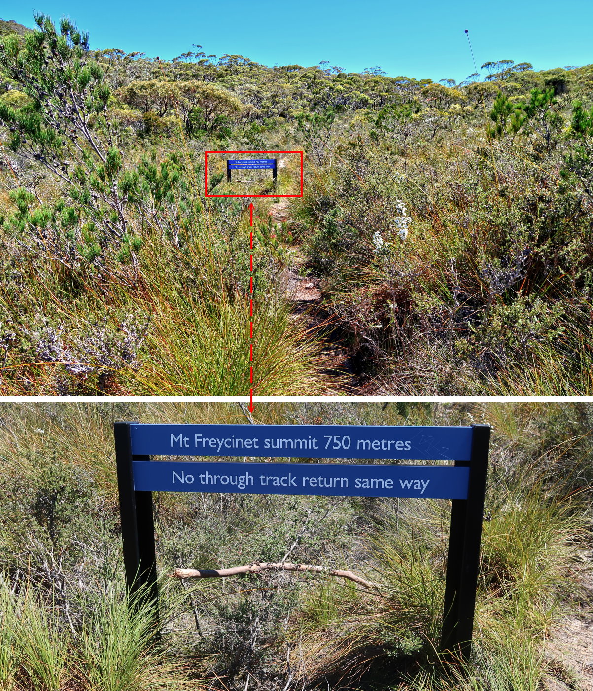
At T-junction of Peninsula Track and the foot track to Mt Freycinet
31) Now at the T-junction of Peninsula Track and the foot track to Mt Freycinet ~~~
There is a sign saying it is 750 meters to the summit of Mt Freycinet ... less than an hour should get you there. The foot track peters out about half way up the slope.
32) Still at the junction ~~~
- Yellow arrows: The route to the summit is along the ridge.

Climb Mt Freycinet
33) The foot track peters out about half way up the slope of Mt Freycinet. Afterwards, there are cairns to guide you up. But don't rely on finding them. Carry a GPS or map & compass with you for the climb.

34) At about where the foot track peters out, I take a break and have lunch. While having lunch, a friendly couple climb down from the summit. I'll catch up with them at Mt Graham later on ... see photos #50 and #56.

35) Besides the cairns of photo #33, there are also orange/red markers nailed to trees to guide you. Again, don't rely on finding them. Take a GPS or map & compass with you for the climb.

36) There are even some orange/yellow ribbons ... here is one of them.

37) I am pleasantly surprised to find these steps near the top of the mountain. Perhaps some volunteers from bushwalking clubs had built them?

38) The final climb to the summit of Mt Freycinet ~~~
- Red circle & oval: It is the same rock in both pics.
- Blue arrow: Turn right to climb up a rocky ramp.
- Right pic: The rocky ramp ... Once you climb up to the top, you are at the summit plateau.

39) Once you've climbed to the top of the rocky ramp of the previous pic, you'll encounter this pile of timber. Who put them here? What are they for?

Mt Freycinet summit
40) This is it, the summit of Mt Freycinet, the red arrow.

41) For those who take the trouble to climb up here ... Towards north, there is a fantastic view of Wineglass Bay and Freycinet National Park.
- Upper pic:
• Small body of water on left edge: Hazards Lagoon
• The bay at the centre: Wineglass Bay (and Wineglass Beach)
• The 5 red arrows point to, from left to right:
1 Wineglass Bay Lookout (photos #9 and #10)
2-5: 2 Mt Amos, 3 Mt Dove, 4 Mt Baudin, 5 Mt Parsons (I'll climb Mt Amos 2 days later.)
• Yellow arrows on the left: My route to Hazards Beach in the morning
• Yellow arrows on the right: Return route back to the car
- Lower pic:
• See also photo #44's lower pic which has a better view of this area.
• The 3 bodies of water from left to right:
1 Coles Bay
2 Hazards Lagoon
3 Wineglass Bay (Beyond Wineglass Bay is Tasman Sea.)
• The 7 red arrows point to, from left to right:
1 Rocky lookout, part of Mt Freycinet summit: I'll be there next.
2 Mt Mayson
3 Wineglass Bay Lookout (photos #9 and #10)
4-7: 4 Mt Amos, 5 Mt Dove, 6 Mt Baudin, 7 Mt Parsons
• Yellow arrow on the left: My route to Hazards Beach in the morning
• Yellow arrows on the right: Return route back to the car later on
- Continuation to the right of the lower pic is photo #42. Together they form a 360-degree panorama.

called The Hazards Traverse.
I'll do it 2 years later in 2019 February as a day trip. Photographs and trip report are in my blog:
http://mntviews.blogspot.com/2019/02/the-hazards-amos-dove-baudin-parsons.html
42) The previous pic plus the 3 pics below form a 360-degree panorama from Mt Freycinet summit.
- Upper pic: (Continuation to the right of photo #41)
• Red arrow: Mt Graham ... north-east-ish. ... I'll be at its summit about 1 hour 25 minutes later.
• Yellow arrows: My route to Mt Graham; and descend from it afterwards
• The sea here is Tasman Sea
- Middle pic: (Continuation to the right of the upper pic)
- Lower pic: (Continuation to the right of the middle pic)
• Red arrow: Rocky lookout, part of Mt Freycinet summit: I'll go there next.
- Continuation to the right of the lower pic is photo #41, thus completing a 360-degree panorama.

Rocky lookout at Mt Freycinet summit
43) Heading to a nearby rocky lookout, the highest rock in this pic ~~~
It is the same rock pointed to by the red arrow in the previous pic.

44) Now at the rocky lookout ~~~
- Upper pic:
• The 2 bays on the left:
1 Coles Bay ... upper
2 Promise Bay (and Hazards Beach) ... lower
• Dark lake in the middle: Hazards Lagoon
• The bay on the right: Wineglass Bay (and Wineglass Beach)
• The 4 red arrows point to, from left to right:
1 Mt Mayson
2 Wineglass Bay Lookout (photos #9 and #10)
3 Mt Amos
4 Mt Dove
• Yellow arrows: My route for the day
- Lower pic:
• The 6 red arrows point to, from left to right:
1 Mt Mayson
2 Wineglass Bay Lookout (photos #9 and #10)
3-6: 3 Mt Amos, 4 Mt Dove, 5 Mt Baudin, 6 Mt Parsons
• Yellow arrows on the left: My route in the morning
• Yellow arrows on the right: Return route back to the car later on
- Continuation to the right of the lower pic is photo #45. Together they form a 360-degree panorama.

45) The previous pic plus the 3 pics below form a 360-degree panorama.
- Upper pic: (Continuation to the right of previous pic)
• The sea here is Tasman Sea.
• Red arrow: Mt Graham ... north-east-ish. ... I'll be at its summit about 1 hour 20 minutes later.
• Yellow arrows: My route ... The double-headed arrow is the route to climb Mt Freycinet.
• Red dot: Same area as photos #31 and #46 ... T-junction of Peninsula Track and the foot track to climb Mt Freycinet
- Middle pic: (Continuation to the right of the upper pic)
• Red arrow: Summit of Mt Freycinet (By contrast, the summit in photo #40 was taken in the opposite direction.)
• The sea on the left is Tasman Sea.
• The water on the right is the bay between Tasmania main land and Freycinet Peninsula.
- Lower pic: (Continuation to the right of the middle pic)
• Red arrow: Refuge Island (See photo #15 and the lower pic of photo #16.)
- Continuation to the right of the lower pic is photo #44, thus completing a 360-degree panorama.

Back at T-junction of Peninsula Track and foot track to Mt Freycinet
46) I've climbed down Mt Freycinet and is back at the T-junction of Peninsula Track and the foot track to Mt Freycinet.
- Red dot: The T-junction
- The 3 yellow arrows, from left to right:
1 Peninsula Track - to Mt Graham ... I'm going there next.
2 Foot track to and from Mt Freycinet
3 Peninsula Track - from Cooks Beach ... I came from there.

47) Still at the T-junction (and continuation to the left of previous pic) ~~~
The 4 red arrows point to, from left to right:
1 Mt Amos
2 Mt Dove
3 Mt Baudin
4 The summit of Mt Graham is just behind the arrow.

To Mt Graham
48) On the way to Mt Graham and looking back at Mt Freycinet ~~~
- To enlarge the image, click on it.
- The 5 red arrows point to, from left to right:
1 Mt Freycinet
2 Refuge Island (See also photo #15 and the lower pic of photo #16.)
3 Hazards Beach
4 Hazards Lagoon
5 Mt Mayson
- Red dot: T-junction of Peninsula Track and the foot track to Mt Freycinet ... See photo #46.
- Yellow arrows: My route

49) The Peninsula Track ~~~
It has some steep and rough sections, because it is climbing up towards Mt Graham.

50) I am catching up with the couple I met on the slope of Mt Freycinet ... see photo #34.
The Peninsula Track doesn't go through the summit of Mt Graham. Where we are now is very near the closest approach to the summit.

Flat rock area - closest approach to Mt Graham summit
51) A few steps beyond where the previous pic was taken, the couple and I reach a flat rock area.
Here is me with Mt Freycinet (left arrow) and Mt Graham (right arrow) as background.

52) Nice scenery from the flat rock area: (To enlarge the image, click on it.)
- The 3 red arrows point to, from left to right:
1 Mt Freycinet
2 Mt Graham
3 Rocky outcrop on Mt Graham slope ... I'm going there next, then to the summit of Mt Graham.
- Red oval: Schouten Island

53) (Continuation to the right of previous pic)
- The 5 red arrows point to, from left to right:
1 Wineglass Bay Lookout (photos #9 and #10)
2-5: 2 Mt Amos, 3 Mt Dove, 4 Mt Baudin, 5 Mt Parsons

Climbing towards Mt Graham summit
The couple take a rest on the flat rock area. They are on a multi-day walk and carrying heavy packs. Tonight, they'll set up camp at Wineglass Beach. Tomorrow they'll finish the walk at the carpark.
I go on to climb Mt Graham.
54) I am now on the rocky outcrop, the right-most arrow of photo #52.
- Schouten Island is the main subject of the 2 pics below ... towards south.
- Lower pic: This pic together with the 3 pics in photo #55 form a 360-degree panorama.

55) The previous pic plus the 3 pics below form a 360-degree panorama.
- Upper pic: (Continuation to the right of previous pic)
• The 2 red arrows point to, from left to right: Mt Freycinet, Mt Graham
- Middle pic: (Continuation to the right of the upper pic)
• The 4 red arrows point to, from left to right:
1 Mt Amos, 2 Mt Dove, 3 Mt Baudin, 4 Mt Parsons
• Yellow arrows: My route to Wineglass Bay later on after summitting Mt Graham
• Photo #59 has a similar view.
- Lower pic: (Continuation to the right of the middle pic)
• Red arrow: The couple resting on a flat rock area ... See photo #56.
- Continuation to the right of the lower pic is photo #54, thus completing a 360-degree panorama.

56) This is the couple in the previous pic. They are having a rest on a flat rock area which is the closest approach to Mt Graham on the Peninsula Track.

Mt Graham summit
I am now at the summit of Mt Graham.
57) 180-degree panorama from the summit (To enlarge the image, click on it.) ~~~
- The 8 red arrows point to, from left to right:
1 Western end of Schouten Island
2 Mt Freycinet
3 Refuge Island
4-8 Called The Hazards: 4 Mt Mayson, 5 Mt Amos, 6 Mt Dove, 7 Mt Baudin, 8 Mt Parsons
- The beach to the left of Mt Mayson is Hazards Beach.
- The beach to the right of Mt Mayson is Wineglass Beach.
- Yellow dots: Route to climb Mt Freycinet
- Continuation to the left of this pic is Schouten Island ... See photo #54, or the left half of photo #52.
- Photo #58 zooms into the right half of this pic.

58) Zooming to the right half of previous pic ~~~
- Upper pic:
• The 7 red arrows point to, from left to right:
1 Refuge Island
2 Mt Mayson
3 Wineglass Bay Lookout
4-7: 4 Mt Amos, 5 Mt Dove, 6 Mt Baudin, 7 Mt Parsons
• The beach to the left of Mt Mayson: Hazards Beach
• The beach to the right of Mt Mayson: Wineglass Beach
• Dark body of water between Hazards Beach & Wineglass Beach: Hazards Lagoon
- Lower pic: Zooming into the middle part of the upper pic
• Yellow arrows: My route for the day
- The view here is not as good as photo #44 from Mt Freycinet. So, if you are in this area, you should climb Mt Freycinet as well !

To Wineglass Beach
I've climbed down from Mt Graham. The couple I met earlier are still having a rest on the flat rock area. As they'll spend the night at Wineglass Bay whereas I have to walk all the way back to the car. So I go ahead by myself and leave them to enjoy their rest and the view.
59) Walking on the Peninsula Track towards Wineglass Bay
- The 6 red arrows point to, from left to right:
1 Mt Mayson
2 Wineglass Bay Lookout
3-6: 3 Mt Amos, 4 Mt Dove, 5 Mt Baudin, 6 Mt Parsons
- Yellow arrows: My route back to the car for the remainder of the day

60) Looking back ~~~
- Upper pic:
• Red arrow: Mt Graham
- Middle & lower pics:
• The 2 red arrows point to, from left to right: Mt Graham, Mt Freycinet
• Yellow arrow: Direction I'm walking on Peninsula Track

61) A rock along Peninsula Track

62) Various conditions of the Peninsula Track ~~~
- Yellow arrows: Direction I'm going
- Middle pic: The 2 red arrows point to, from left to right: Mt Amos, Mt Dove

63) Near where the previous pic was taken, there are glimpses of the beautiful Wineglass Bay.
- Upper pic:
• The 3 red arrows point to, from left to right: 1 Mt Mayson, 2 Mt Amos, 3 Mt Dove
- Lower pic:
• Red arrow: Mt Mayson
• Yellow arrows: My route through Wineglass Beach later on

Wineglass Beach campground
Finally, I'm very close to Wineglass Beach.
64) Crossing a creek to enter Wineglass Beach campground

65) One area of the Wineglass Beach campground

Wineglass Beach
66) (To enlarge the image, click on it.)
I am standing at the spot where I entered Wineglass Beach from the campground.
- The 6 red arrows point to, from left to right:
1 Mt Mayson
2 Wineglass Bay Lookout
3-6: 3 Mt Amos, 4 Mt Dove, 5 Mt Baudin, 6 Mt Parsons
- Yellow dots: Route to and from carpark over the saddle to the northern tip of Wineglass Beach
- Photo #67 zooms into the centre-right part of this pic.

67) Beautiful Wineglass Bay ~~~
- Upper pic: Zooms into the centre-right part of previous pic.
• The 5 red arrows point to, from left to right:
1 Wineglass Bay Lookout
2-5: 2 Mt Amos, 3 Mt Dove, 4 Mt Baudin, 5 Mt Parsons
• Yellow dots: Route to and from carpark over the saddle to the northern tip of Wineglass Beach
- Lower pic:
• The 4 red arrows point to, from left to right:
1 Mt Amos, 2 Mt Dove, 3 Mt Baudin, 4 Mt Parsons

68) In case you are wondering what does the bank of Wineglass Beach look like ... here it is.

69) An uprooted tree by the bank of Wineglass Beach ~~~
It is a hot day. I take a few minutes of rest here in the shadow of the upturned root ... Well, there is no shade anywhere along the beach to take a respite from the sun. Sunbathers would love the hot sun, but not me ... I'm walking, not sunbathing :-)

70) (To enlarge the image, click on it.)
Beautiful Wineglass Bay again ~~~
- The 6 red arrows point to, from left to right:
1 Mt Mayson
2 Wineglass Bay Lookout
3-6: 3 Mt Amos, 4 Mt Dove, 5 Mt Baudin, 6 Mt Parsons
- Yellow dots: Route to and from carpark over the saddle to the northern tip of Wineglass Beach
- Yellow arrow: My route down to Wineglass Beach not too long ago
- Photo #71 zooms into the middle part of this pic.

71) Zooming into the middle part of previous pic ~~~
- Upper pic:
• The 6 red arrows point to, from left to right:
1 Mt Mayson
2 Wineglass Bay Lookout
3-6: 3 Mt Amos, 4 Mt Dove, 5 Mt Baudin, 6 Mt Parsons
• Yellow dots: Route to and from carpark over the saddle to the northern tip of Wineglass Beach
- Lower pic: (Continuation to the right of the upper pic)
• The 4 red arrows point to, from left to right:
1 Mt Amos, 2 Mt Dove, 3 Mt Baudin, 4 Mt Parsons

72) (To enlarge the image, click on it.)
Beautiful Wineglass Bay again ~~~
- The 6 red arrows point to, from left to right:
1 Mt Mayson
2 Wineglass Bay Lookout
3-6: 3 Mt Amos, 4 Mt Dove, 5 Mt Baudin, 6 Mt Parsons
- Yellow dots: Route to and from carpark over the saddle to the northern tip of Wineglass Beach
- Yellow arrows: My route down to Wineglass Beach not too long ago

73) Looking back ~~~
- The 2 red arrows point to, from left to right: Mt Graham, Mt Freycinet
- Yellow dots & blue arrows: How I've walked

74) Getting close to the northern end of Wineglass Beach ~~~
- The 4 red arrows point to, from left to right:
1 Mt Mayson
2 Wineglass Bay Lookout
3 Mt Amos (I'll climb Mt Amos 2 days later.)
4 Mt Dove

75) About to leave Wineglass Beach and looking back at where I have been ~~~
- Red arrow: Mt Graham
- Yellow dots & Blue arrows: How I've walked
- Photo #76 zooms into the right half of this pic

76) (Zooming into the right half of previous pic)
- The 2 red arrows point to, from left to right: Mt Graham, Mt Freycinet
- Yellow dots & blue arrows: How I've walked
- Red circle: See photo #77.

Sunbathers
77) Sunbathing ... topless :-)
- Upper & middle pics: Zooming into the red circle of the previous pic

To Wineglass Bay Lookout
Can't ogle at the topless women forever; time to leave :-(
78) Returning to Wineglass Bay Lookout ... feeling tired walking up these steps ... it has been a long day !

Wineglass Bay Lookout (again)
79) Compare to photo #9, there are more people here now.
- The 2 red arrows point t, from left to right: Mt Graham, Mt Freycinet

80) It is most satisfying to be able to review where I have been for the entire day:
- Wineglass Bay and Wineglass Beach is at the centre of the pic.
- Hazard Lagoon and Promise Bay are the 2 bodies of water to the right of Wineglass Bay.
- The 3 red arrows point to, from left to right:
1 Mt Graham
2 Saddle point where I climbed up from the far side of Mt Freycinet, then along the ridge to Freycinet summit
3 Mt Freycinet ... directly south
- Yellow arrows & dots and blue arrows: My route for the day

Return to carpark
81) - From the carpark to Wineglass Bay Lookout, take the left track.
- To return to the carpark, take the track on the right. Probably there are too many tourists, hence the one-way policy to ease the traffic.

82) If you are tired, you can take a rest on chairs set up along the track.

Comment
A very lovely trip, well worth doing it.
Other walks in Freycinet National Park
A challenging walk in Freycinet National Park is The Hazards Traverse ... Climb:
- Mt Amos
- Mt Dove
- Mt Baudin
- Mt Parsons
I'll do it 2 years later in 2019 February as a day trip. Photographs and trip report are in my blog:
http://mntviews.blogspot.com/2019/02/the-hazards-amos-dove-baudin-parsons.html
No comments:
Post a Comment