2017-Jan & 2019-Feb Climb Mt Amos in Freycinet National Park, Tasmania, Australia ... day trip
Prolog - Mt Amos


I have combined my 2 climbing trips to Mt Amos into this one report:
2017 January: Climb Mt Amos only
2019 February: Phase 1 of Hazards traverse ... climb Mt Amos ... this trip report
(Phase 2 of Hazards traverse ... climb Mt Dove, Mt Baudin, Mt Parsons ... trip report is in:
https://mntviews.blogspot.com/2019/02/the-hazards-amos-dove-baudin-parsons.html )
Map
OpenStreetMap:
- Left brown arrow: Wineglass Bay Lookout
- Right brown arrow: Mt Dove
- Small blue dot: Mt Amos summit

GPS tracklog files & route
The GPX tracklog files of my walk can be downloaded from:
2017-Jan: https://drive.google.com/open?id=17hznuzivff7Joj55fBzHt1WW9WB2Xz2G
2019-Feb: https://drive.google.com/open?id=1CyK4PkgYJiggj0hSlrwg0KTihJFZzU6r
Contour map ... my route is in red:
- Brown arrow on right edge: Mt Dove
- 3 blue arrows from top to bottom:
1 A bunch of boulders ... Refer to photos #38 and #39
2 Rock platform ... Refer to photo #51
3 Mt Amos summit

OpenStreetMap ... my route is in brown:
- Left brown arrow: Wineglass Bay Lookout
- Right brown arrow: Mt Dove
- 3 blue arrows from top to bottom:
1 A bunch of boulders ... Refer to photos #38 and #39
2 Rock platform ... Refer to photo #51
3 Mt Amos summit

Satellite view of my route in brown:

In summary, the route is:
- Park car at a carpark towards the end of Freycinet Drive.
- Walk on marked trail to Mt Amos summit. While near the top, detour to a bunch of boulders ... photos #38 and #39
- 2017-Jan: Return to carpark after summitting
- 2019-Feb: Keep going to Mt Dove, Mt Baudin, Mt Parsons ... trip report will be written up soon :-)
Timeline & Distance
Park car at a carpark towards the end of Freycinet Drive.
The carpark is the start of Wineglass Bay / Mt Amos walking tracks.
2019 Feb 2017 Jan Comment
============= ============= =======
07:22 0.0 km 07:11 0.0 km Start walking from carpark
08:39 2.1 km 08:27 2.3 km Leave main track, going to a bunch of boulders
08:42 2.15km 08:31 2.35km At top of the bunch of boulders
08:44 2.2 km 08:33 2.4 km Leave the bunch of boulders
08:47 2.25km 08:37 2.45km Back at the same spot as at 08:39 / 08:27
08:50 2.35km 08:40 2.5 km At Mt Amos summit
To Mt Dove - -
- - 09:03 2.7 km Leave Mt Amos summit
- - 10:06 4.85km Back at carpark
=============================================
Total:
- 2 hrs 55 mins
- 4.85 km Distance from Google Earth
- 5.3 km Distance from Garmin GPS
Pictures
Photographs are sourced from both the 2019-Feb and 2017-Jan trips.
Carpark
Carpark is at the end of Freycinet Drive.
It is also the start of Wineglass Bay / Mt Amos walking tracks.
If you want a parking space, make sure you reach there early, by 7am.
1) 2019-Feb:
- Yellow arrow: The way to the walking tracks
- 2 red arrows from left to right:
1 My Kathmandu Voltai 40 backpack, bought from a Kathmandu shop in Sydney.
Ok for on-track walking, not good for bushbashing & rock scrambling ... Its outer fabric can't stand rough treatment.
2 Toyota Corolla, a hire car during my stay in Tasmania

Mt Amos walking track
2) The earlier sections of Mt Amos walking track ~~~
- The track gets quite rough later on :-)
- You won't be lost, there are orange/yellow markers and coloured ribbons along the track to guide you.

Climbing up Mt Amos - 1
3) Mt Amos comes into view ~~~
The summit itself is further back. It can't be seen from here. (It is behind the highest point in these 2 pics.)
- Upper pic: 2019-Feb, 7:41am
• Cyan circle: A yellow marker nailed to the ground
• Yellow arrows: Route to Mt Amos (for the time being)
• Red arrow: Later on, the route will be through this gap.
• White arrows: Same as the 2 rocks pointed by the white arrows in photo #4
- Lower pic: 2017-Jan, 9:52am ... Zooming into the middle of the upper pic
• Taken on a different date, hence the difference of the sky compared to the upper pic

4) Mt Amos ~~~
- Upper pic: 2019-Feb, 7:43am
• White arrows: Same as the 2 rocks pointed by the white arrows in photo #3
- Lower pic: 2017-Jan, 9:53am ... different date, hence the difference of the sky compared to the upper pic
• Wonderful cloud pattern ... Can someone please tell me what type of clouds are they?

5) Near where the previous pic was taken and facing backwards (To enlarge the image, click on it.) ~~~
- White oval: The town of Coles Bay
- The bay in front of the town is also called Coles Bay.
- Horizontal red arrow: Picnic Island
- Vertical red arrow: Mt Stacey
- Small yellow dot: Direction where my hire car is parked ... line of sight blocked by the rock

6) Panorama from further up the slope ~~~
- Upper pic:
• Mt Amos is near the left edge. The summit is further back and can't be seen from here.
• Red arrow: The way to the summit is through the gap there.
- Lower pic: (Continuation to the right of the upper pic) Facing backward
• White oval: The town of Coles Bay
• The bay in front of the town is also called Coles Bay.
• Horizontal red arrow: Picnic Island
• Vertical red arrow: Mt Stacey
• Small yellow dot: Where my hire car is parked.
• White arrow: Same rock as pointed by the left white arrow in photo #4

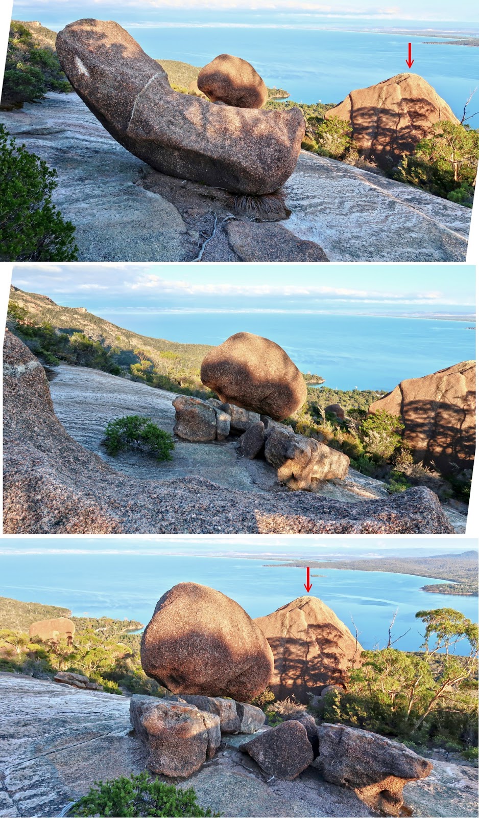
An interesting boulder
7) An interesting boulder with Mt Amos in the background

8) The interesting boulder ~~~
- Upper pic: Zooming into the left hand side of previous pic
- Middle & lower pics: The boulder from different angles

Climbing up Mt Amos - 2
9) Fascinating water marks on the rocks

10) Aside from orange/yellow markers nailed to rocks, there are also coloured ribbons along the trail.
- Yellow arrows: Route to summit
- The summit can't be seen from here. It is behind the highest point in this pic.

11) The 2 pics below and the 2 pics in photo #12 form a 360-degree panorama from the slope of Mt Amos
- Upper pic:
• Yellow arrow: Trail to where I'm now
- Lower pic: (Continuation to the right of the upper pic)
• Yellow arrows: Trail to Mt Amos summit
• Mt Amos is at the centre of the pic. But the summit is further back and can't be seen from here.
• Cyan square: An orange marker nailed to a rock
• Photo #13 zooms into the right half of this pic.

12) (Continuation to the right of previous pic)
- Upper pic:
• Red arrow: The boulder in photo #16
- Lower pic: (Continuation to the right of the upper pic)
• White oval: The town of Coles Bay
• The bay in front of the town is also called Coles Bay.
• Horizontal red arrow: Picnic Island
• Vertical red arrow: Mt Stacey
• Small yellow dot: Where my hire car is parked.
• Shadow near left edge: Me :-)
- Continuation to the right of the lower pic is photo #11, thus completing a 360-degree panorama.

13) Zooming into the right half of photo #11 ~~~
- Yellow arrows: Trail to Mt Amos summit
- Mt Amos summit is behind the highest point in this pic and can't be seen from here.
- Cyan circles: Orange/yellow markers nailed to rocks

Rock patterns on the ground
14) Plenty of this type of fascinating patterns on the ground.

15) Both pics below are of the same scene ... Love these patterns.

More interesting boulders
16) This is the boulder pointed by the red arrows in photos #12 and #17.

17) The 2 red arrows below point to the same boulder as in photos #12 and #16.
Climbing up Mt Amos - 3
18) A sample of the trail heading to Mt Amos summit ~~~
- Red circles: Yellow markers nailed to rocks to guide you up

19) Coles Bay from further up the slope (To enlarge the image, click on it.) ~~~
- White oval: The town of Coles Bay
- The bay in front of the town is also called Coles Bay.
- Horizontal red arrow: Picnic Island
- Vertical red arrow: Mt Stacey
- Small yellow dot near centre of pic: Where my hire car is parked
- This pic and the 3 pics in photo #20 form a 360-degree panorama.

20) Panorama ~~~
- Upper pic: (Continuation to the right of previous pic)
- Middle pic: (Continuation to the right of the upper pic)
• This is the trail to Mt Amos summit.
• Cyan square: Pink ribbons guiding you up
- Lower pic: (Continuation to the right of the middle pic)
- Continuation to the right of the lower pic is photo #19, thus completing a 360-degree panorama.

21) Further up the slope ~~~
- The 2 pics below are from the 2017-Jan trip. I started the climb at 7:11am. But some others started even earlier. This group have reached the summit and are on their way down.

22) At where the previous pic was taken and looking back towards the carpark ~~~
- Yellow dot: Where my hire car is parked

Climbing up Mt Amos - open rocky slope
23) Another look at Coles Bay ~~~
- White oval: The town of Coles Bay
- The bay in front of the town is also called Coles Bay.
- Horizontal red arrow: Picnic Island
- Vertical red arrow: Mt Stacey
- Small yellow dot near centre of pic: Where my hire car is parked
- This pic and the 2 pics in photo #24 form a 360-degree panorama.

24) Panorama ~~~
- Upper pic: (Continuation to the right of previous pic)
- Lower pic: (Continuation to the right of the upper pic)
- Continuation to the right of the lower pic is photo #23, thus completing a 360-degree panorama.
- Red squares: Photo #25 zooms into this area.
- Yellow arrows: Trail to Mt Amos summit
- White ovals: Same as the tree in the white ovals of photos #25, #26, #27
- The upper pic is taken in 2019-Feb. The slopes are in the shade in a sunny morning. Whereas the lower pic was taken in 2017-Jan in a cloudy morning ... thus the difference in colour in the pictures.

25) Zooming into the red squares of photo #24 ~~~
- Yellow arrows: Trail to Mt Amos summit
- White ovals: Same as the tree in the white ovals of photos #24, #26, #27
- The upper pic was taken in 2017-Jan, a cloudy morning. Whereas the lower pic is taken in 2019-Feb, in the shade in a sunny morning ... thus the difference in colour in the pictures.

26) Some hikers on the trail to Mt Amos summit (2019-Feb) ~~~
- White ovals: Same as the tree in the white ovals of photos #24, #25, #27

27) Looking back at the trail ~~~
- White oval: Same as the tree in the white ovals of photos #24, #25, #26
- Yellow dot: Where my hire car is parked
- Yellow arrows: Route from carpark to where I am now

Climbing up Mt Amos - 4
28) Further up Mt Amos slope ~~~
- Yellow arrow: The trail
- Red square: Pink & blue ribbons on a tree to guide you up

29) Looking down the slope ~~~
- White oval: The town of Coles Bay
- Red arrow: Picnic Island

30) Trail to Mt Amos summit
- White arrows: They point to the same rock
- Yellow arrow: Trail up the slope

31) Looking down the slope at an interesting rock
- Yellow arrows: Trail up the slope

32) Mt Amos summit comes into view ~~~
• Red arrow: Mt Amos summit
• Yellow arrow: Trail to the summit
- Lower pic: Zooming into Mt Amos summit
• A guy is taking photographs from the summit
33) A little further along the trail is this panorama ~~~
- Upper pic:
• Red arrow: Mt Amos summit
- Lower pic: (Continuation to the right of the upper pic)
• Facing backwards
• Yellow arrows: The trail I walked on to reach here

34) Closer to Mt Amos summit ... the 2 pics here and the 3 pics in photo #35 form a 360-degree panorama.
- Upper pic:
• 2 red arrows from left to right:
1 I'll detour to climb up this bunch of boulders first ...
2 ... then to Mt Amos summit
- Lower pic: Zooming to the right side of the upper pic
• Red arrow: Mt Amos summit
• Yellow arrow: The trail to Mt Amos summit ... The final climb to the summit is from the back.
• Continuation to the right of this pic is photo #35

35) Panorama ~~~
- Upper pic: (Continuation to the right of previous pic)
• 2 rocky knolls on the right side of the pic are the same as the ones in photo #33's lower pic.
- Middle pic: (Continuation to the right of the upper pic)
- Lower pic: (Continuation to the right of the middle pic)
- Continuation to the right of the lower pic is photo #34, thus completing a 360-degree panorama.

36) Someone, not me, scribbled these words on a yellow marker:
- I want to have a cold Coca Cola

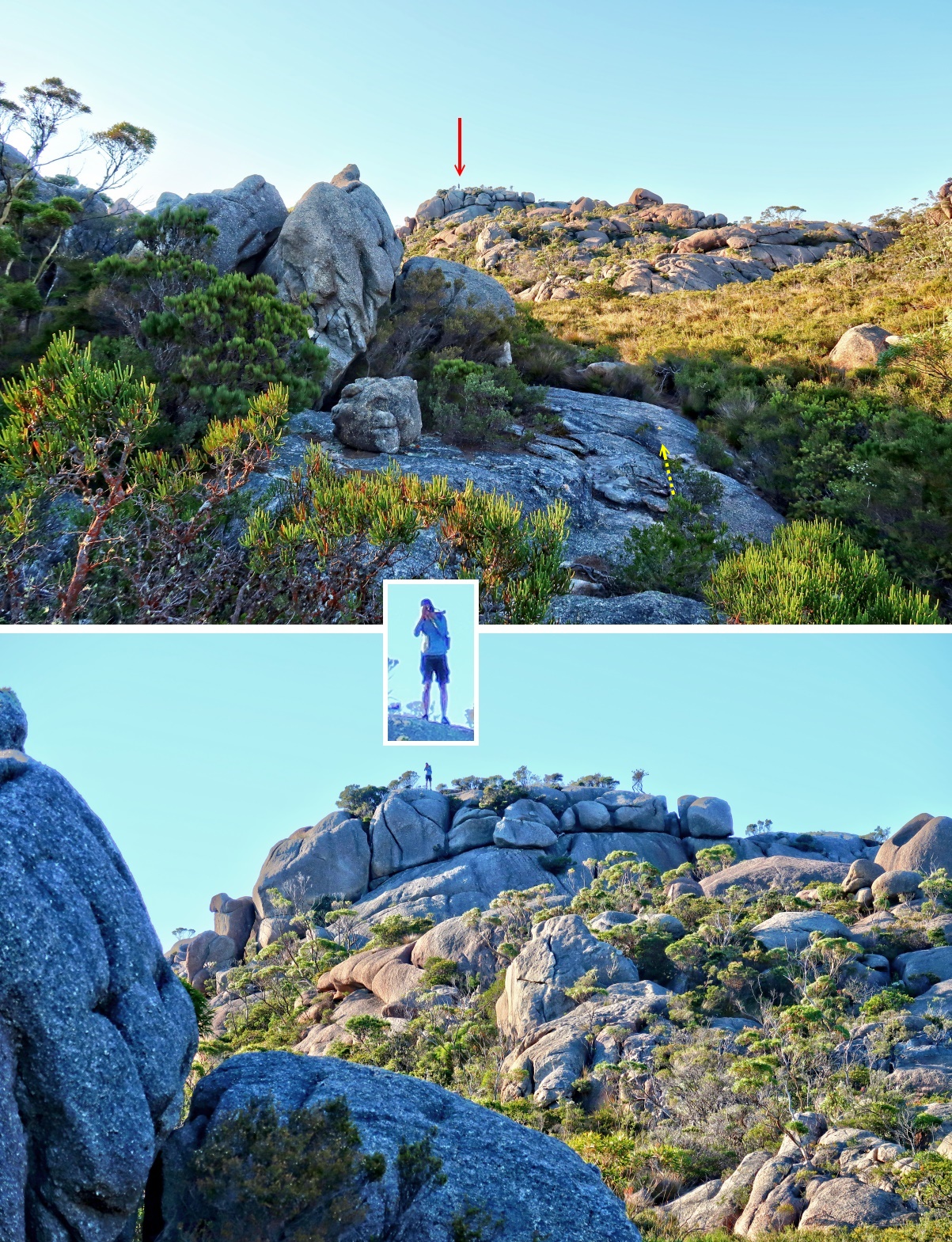
Detour to a bunch of boulders
Before climbing up Mt Amos summit, I make a detour to a bunch of boulders ... the red arrow on the left edge of photo #34's upper pic.
37) To head for the bunch of boulders, need to climb up a small plateau first via the slit in this pic.
- When facing Mt Amos, this slit is on the left side of the trail to the summit.
(There are a few ways up the plateau, not just the one shown here.)
- Yellow arrows: The way up ... Once up, turn left.
- Yellow dot at top of the pic: Photo #38 is taken from this spot.

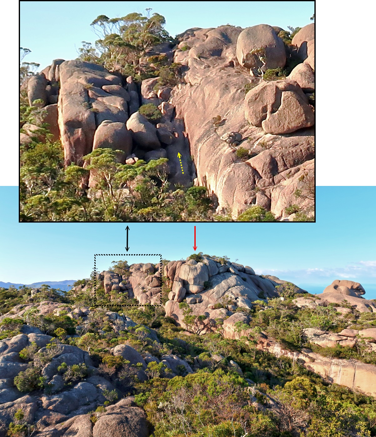
38) Facing the bunch of boulders I am going to climb ~~~
- Upper pic: Taken from the yellow dot of previous pic
• Red arrow: Mt Stacey
- Lower pic: Closer to the bunch of boulders
• White oval: The town of Coles Bay
• The bay in front of the town is also called Coles Bay.

At the bunch of boulders
39) The bunch of boulders ~~~
- Upper pic:
• Red arrow: Mt Stacey
• White oval: The town of Coles Bay
• The bay in front of the town is also called Coles Bay.
- Lower pic: About to climb to the top of the highest boulder ... the one in the middle and at the very back ... not hard to climb :-)

40) From the top of the bunch of boulders is this view towards Mt Amos.
- Red arrow: Mt Amos summit
- Yellow arrow: Trail to Mt Amos summit ... The final climb to the summit is from the back.
- This pic and the 3 pics in photo #41 form a 360-degree panorama.
41) Lovely panorama from the top of the bunch of boulders ~~~
- Upper pic: (Continuation to the right of previous pic)
• Red arrow: Mt Mayson ... towards west
• 2 blue arrows: Same as the 2 rocky knolls in photos #33's lower pic, and photo #35's upper pic
• Yellow arrow: Trail to climb up Mt Amos
- Middle pic: (Continuation to the right of the upper pic)
• Red arrow: Mt Stacey
• White oval: The town of Coles Bay
• The bay in front of the town is also called Coles Bay.
- Lower pic: (Continuation to the right of the middle pic)
• Red arrow: Mt Dove ... towards east, highest peak in the Hazards Mountain Range
- Continuation to the right of the lower pic is photo #40, thus completing a 360-degree panorama.

Climb to the summit of Mt Amos
42) I have descended the bunch of boulders in photo #39, now on the final stage of the climb to the summit of Mt Amos. (The summit is beyond the upper right corner of this pic.)
- Yellow arrows: Trail to the summit ... Then turn right and climb to the summit from the back.
- White arrow: A yellow marker to guide you up
- This pic is taken around the area of the yellow arrow in photo #40.

At Mt Amos summit - 454 meters
Now at the summit of Mt Amos, 454 meters
Photos #43 to #47 form a 360-degree panorama.
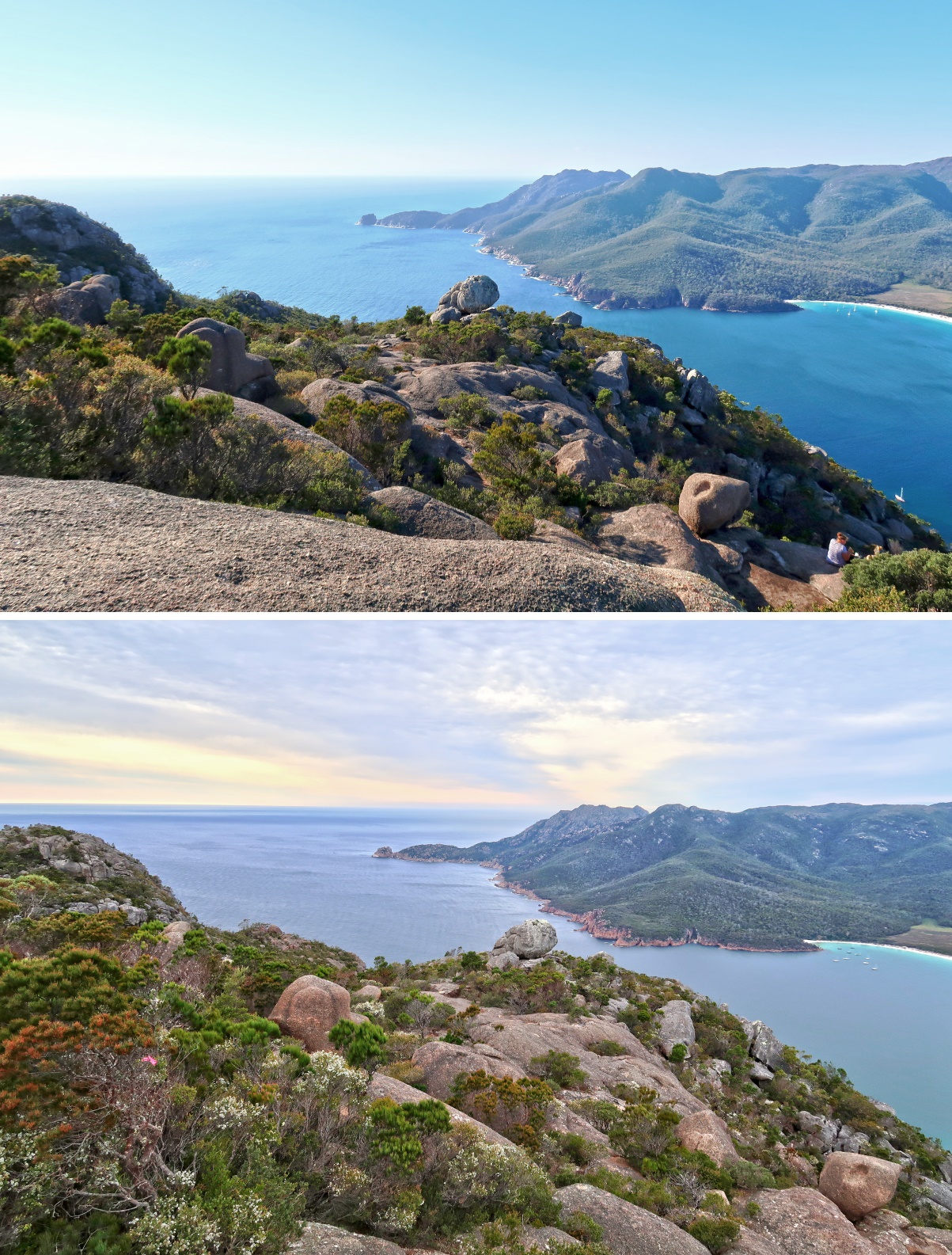
43) Mt Dove and its summit trig ... east-ish

44) (Continuation to the right of previous pic)
- 2 red arrows from left to right:
1 Mt Graham
2 Mt Freycinet ... south
- Wineglass Bay & Wineglass Beach are near the middle of the pic.
- To the right of Wineglass Beach is Hazards Lagoon.
- To the right of Hazards Lagoon is Promise Bay.
- Photos #48 #49 #50 zoom into the centre of this pic.
I roamed all over Mt Graham, Mt Freycinet, Wineglass Beach in 2017-Jan. Photos and trip report are in my blog:
http://mntviews.blogspot.com.au/2017/01/mt-freycinet-mt-graham-wineglass-beach.html

45) (Continuation to the right of previous pic)
- Facing Mt Mayson, the mountain in the background ... west-ish
- The letters on the rock seem to be MUP. Are these letters natural? If not, what does MUP stand for?
- Upper pic: 2017-Jan-28 Saturday 8:40am ... No one here at the summit on a weekend except the young woman in the lower pic.
- Middle pic: 2019-Feb-18 Monday 8:57am ... Probably around 25 people at the summit on a Monday.
- Lower pic: 2017-Jan ... This beautiful young woman took photo #49's lower pic ... saves me from doing a selfie :-)

46) (Continuation to the right of photo #45)
- Yellow oval: One can climb up this platform ... Refer to photo #51.

47) (Continuation to the right of photo #46)
- 2 red arrows from left to right:
1 I climbed to the top of these boulders not long ago ... Refer to photos #38 and #39.
2 Mt Stacey ... north
- Continuation to the right of this pic is photo #43, completing a 360-degree panorama.

48) Zooming into the main features of photo #44 ~~~
- 4 red arrows from left to right:
1 It is possible to climb to the top of this rock, not easy, but doable. (No. I won't be climbing it.)
2 Mt Graham
3 Mt Freycinet ... south
4 Hazards Lagoon
- Wineglass Bay & Wineglass Beach are at the middle of the pic.
- To the right of Hazards Lagoon is Hazards Beach & Promise Bay.
- Continuation to the left of this pic is photo #50.

http://mntviews.blogspot.com.au/2017/01/mt-freycinet-mt-graham-wineglass-beach.html
49) Zooming into the middle part of previous pic ~~~
- Red arrows in both pics below: Refer to photo #48 for commentaries on them.
- Upper pic: 2019-Feb: It has been a dry summer, otherwise water would fill up all the dirt-brown area in Hazards Lagoon.
- Lower pic: 2017-Jan: Me ... photo taken by the young lady in photo #45's lower pic

50) Continuation to the left of previous pic ~~~
- Round-ish rock at centre of pic: Same as the one pointed by the left-most arrow in photos #48 and #49 ... It is possible to climb to the top of it, not easy, but doable. (No. I won't be climbing it.)
- Bay & beach on right edge of the pic: Wineglass Bay & Wineglass Beach
- Upper pic: 2019-Feb
- Lower pic: 2017-Jan
Rock platform at Mt Amos summit
51) This is the rock platform in the yellow oval of photo #46 ... going to climb it now.

52) 2017-Jan: Facing Mt Amos summit ... photo taken from top of the rock platform of previous pic ~~~
- This photo, together with the 3 pics in photo #53, form a 360-degree panorama.
- Black arrow: My Deuter Futura Pro 36 backpack and walking poles at the summit :-)
The backpack is very sturdy, suffered many abuses on abrasive rocks, but still in good condition !
- 4 red arrow clockwise from top to right edge:
1 Mt Graham
2 Mt Freycinet ... south
3 southern tip of Hazards Beach
4 Hazards Lagoon

53) Panorama from the top of the rock platform in photo #51 ~~~
- Upper pic: (Continuation to the right of previous pic)
• 3 red arrow from left to right:
1 Hazards Lagoon
2 Hazards Beach
3 Promise Bay
• Large mountain at centre of the pic: Mt Mayson ... west-ish
- Middle pic: (Continuation to the right of the upper pic)
• 2 blue arrows: Same as the rocky knolls under the 2 blue arrows in photo #41
• 2 red arrows from left to right:
1 Mt Stacey ... north
2 I climbed to the top of these boulders not long ago ... Refer to photos #38 and #39.
• White oval: The town of Coles Bay
• The bay in front of the town is also called Coles Bay.
- Lower pic: (Continuation to the right of the middle pic)
• Red arrow: Mt Dove ... You can just make out its summit trig ... towards east, highest peak in the Hazards
- Continuation to the right of the lower pic is photo #52, thus completing a 360-degree panorama.

Flora & Fauna
54) Leptospermum (Tea Tree), but which species ?
- Plenty of them near the trailhead

55) A large ant found half way up the slope of Mt Amos ~~
Anyone know the species of this ant? Please let me know.

56) Banksia marginata

Next
2017-Jan: After summitting Mt Amos, I retrace the steps back to the carpark.
2019-Feb: I go on to traverse the rest of The Hazards Mountain Range ... Mt Dove, Mt Baudin, Mt Parson.
Photos and trip report are in https://mntviews.blogspot.com/2019/02/the-hazards-amos-dove-baudin-parsons.html
No comments:
Post a Comment