Today 2020 December & 2018 July
Day-trip Sunnyside Canyon
Acoustic Chamber
Cleft Point (2020-Dec only)
in Gardens of Stone National Park, NSW, Australia
Preview
Sunnyside Canyon
Acoustic Chamber

Quick preview of other photos is in this link:
https://drive.google.com/file/d/1vhMO6iZqbALUsnYnkliMbGNr-Luv-ps4/view?usp=sharing
Reference
Sunnyside Canyon:
https://www.bushexplorers.com.au/encyclopaedia/sunnyside-canyon
Acoustic Chamber:
https://www.bushexplorers.com.au/encyclopaedia/acoustic-chamber
Cleft Point:
https://www.bushexplorers.com.au/encyclopaedia/cleft-point
Postscript
In 2023-May,
a group of us will go to:
- Acoustic Chamber
- Foxs Wedge.
Foxs Wedge is a fascinating place.
Well worth a visit !
Some interesting pictures are in this link:
https://drive.google.com/file/d/1GjxcMcfYoT46MQTahV0kZRJe1O9fnKC1/view?usp=share_link
Our group
Today, 2020-Dec,
5 of us:
- Paul, leader
- Lee
- Stanley
- WenSheng
- ZCC Anna
go for an interesting bushwalk in
Gardens of Stone National Park.
Prolog
Today, we'll visit:
- Sunnyside Canyon
- Acoustic Chamber Within Sunnyside Canyon
- Cleft Point Tip of a finger-like peninsula
north of No 8 Firetrail
Confession:
I have been to
Sunnyside Canyon
Acoustic Chamber
almost 2 and a half years ago in 2018 July,
with CB, Harold, EC, FM, NC.
But I forgot all about it !
Dementia comes too early 😭
Not to worry, as this is an interesting place,
well worth another visit ...
especially with great companies like
Lee, Stanley, WenSheng and ZCC !
Below then is a combined report on both
the 2018-July trip,
and today's 2020-Dec trip.
Pictures though are mostly from today's trip,
with a few from 2018-July.
Book
Trip report on a bushwalk
to Sunnyside Canyon,
and Acoustic Chamber,
minus the walk to Cleft Point,
is in:
"The Gardens of Stone National Park and beyond,
Book 6"
by Michael Keats and Brian Fox
Chapter 6.10 - "Sunnyside Canyon and Ravines"
Chapter 6.11 mentions a walk
to Flat Bottom Creek and Cleft Point.
But you won't find anything useful there
about Cleft Point.
Map
LPI 1:25,000 scaled 8931-3N Cullen Bullen
Map 1) The relevant part of the 1:25,000
topographic map

In the above map, No 8 Firetrail ends
at a barricade at the boundary
between Newnes State Forest
and Gardens of Stone National Park.
(The darker green line)
The firetrail continues north as a disused road
to a lookout at a cliff edge.
In Map 2 below,
the lookout is the 2nd blue arrow from the top.
GPS tracklog files & route
The GPX tracklog files can be downloaded from:
2020-Dec trip:
https://drive.google.com/file/d/1_v4vnlIvA2NH3CbvUK2BvVD_D8JuAtIk/view?usp=sharing
2018-July trip:
https://drive.google.com/file/d/1I8Cb3_1dc2SPiFQSF-VZI3-9Vsl9TrgN/view?usp=sharing
Map 2) Today (2020-Dec):
GPS tracklog, clockwise in red, is in
the 1:25,000 topographic map below:
- 10 blue arrows, top to bottom:
1 GR 3619 1494 Cleft Point
2 GR 3572 1427
Cliff edge where a disused road ends
3 GR 3541 1370
Northern (downstream) end of
Sunnyside Canyon
4 GR 3541 1360
Bottom of steep slope (a dry water fall)
where we climb out of the canyon
5 GR 3541 1357
Bottom of narrow slot which connects
the canyon with the plateau above
6 GR 3537 1347 Unnamed cave ...
on east side of Sunnyside Canyon
7 GR 3537 1338 Acoustic Chamber ...
on east side of Sunnnyside Canyon
8 GR 3536 1319
Start of Sunnyside Canyon ...
We climb down to the canyon
around here.
9 GR 3584 1293
Barricade at end of No 8 Firetrail
10 GR 3548 1204
Where our car is parked today

Map 3) 2018-July:
GPS tracklog, clockwise in red, is in
the 1:25,000 topographic map below:
- We took 2 cars, Harold's & CB's cars ...
Parked at GR 3584 1293,
a barricade at end of No 8 Firetrail.
- We didn't go to Cleft Point.

Map 4) Satellite image of Map 2.

In summary, today's (2020-Dec) route is:
- Park Stanley's car at GR 3548 1204,
on No 8 Firetrail (off Sunnyside Ridge Rd).
- Walk northward on No 8 Firetrail
until we reach a barricade.
- 50 meters further along the firetrail,
go off-track by turning west.
- Explore pagodas on west side of
Sunnyside Canyon.
- Climb down to the canyon.
- Walk northward along the canyon.
- Visit Acoustic Chamber.
- Visit an unnamed cave.
- Reach the northern end of the canyon.
- Retrace steps part of the way.
- Climb out of the canyon via a steep slope.
(A dry waterfall)
- Explore a narrow slot which connects
Sunnyside Canyon with its east side plateau.
- Explore pagodas on the east side
of the canyon mouth.
- To Cleft Point.
- Return to car ... Make a beeline for it.
Timeline and Distance - Today 2020-Dec
Park Stanley's car at GR 3548 1204,
on No 8 Firetrail (off Sunnyside Ridge Rd).
We would have liked to park the car
further along the firetrail.
But the dirt road becomes a bit rough further on.
09:27 0.0 km GR 3548 1204 Start walking
09:44 1.1 km GR 3584 1293
At a barricade on No 8 Firetrail
(Photo #4 ...
We would have liked to park
the car here.)
09:47 1.15km GR 3582 1297
Leave dirt road ... Go off-track
by turning left (west).
10:12 2.0 km GR 3528 1307
On top of the 1st pagoda
on the west side of
Sunnyside Canyon
10:13 2.0 km Leave pagoda
10:33 2.27km GR 3534 1321
On top of the last pagoda
on the west side of the canyon
10:37 2.3 km Leave pagoda ...
Descend to Sunnyside Canyon
10:43 2.38km GR 3536 1319
At start of the canyon
10:48 2.45km GR 3537 1325
Climb up east bank of the canyon
Explore around
10:58 2.49km Back at Sunnyside Canyon ...
Same spot as at 10:48
10:59 2.5 km GR 3537 1326
Stop to watch Stanley and ZCC
climbing up a high pagoda
11:06 2.55km Resume walking
11:31 2.7 km GR 3537 1338
At Acoustic Chamber
11:58 2.7 km Resume walking
12:04 2.8 km GR 3537 1347
At an unnamed cave
Lunch
12:30 2.8 km Resume walking
12:38 2.93km GR 3541 1357
At bottom entrance of a
narrow slot which connects
the canyon and the plateau above
12:44 3.06km GR 3541 1370
At northern (downstream)
end of the canyon
Today, 2020-Dec, we turn around here.
In 2018-July, a group of us continued
a little further north along the east side ledge.
12:48 3.1 km Retrace steps southward,
back along Sunnyside Canyon
12:57 3.25km GR 3541 1357
At bottom entrance of the narrow
slot ... same spot as at 12:38.
Today, we are not going
inside this entrance.
But in 2018-July,
we went in and climbed out
of the canyon via this slot.
12:58 3.28km GR 3541 1360
At bottom of steep slope
(a dry waterfall)
near the narrow slot.
13:02 3.3 km GR 3542 1360
At top entrance of the narrow slot
which connects down to the canyon
Explore the inside of the narrow slot,
including exiting out of its bottom entrance.
13:20 3.42km Resume walking
13:26 3.5 km GR 3541 1363
On top of pagodas on the
east side of the canyon mouth
13:37 3.53km Leave the pagodas
13:50 4.1 km At a disused dirt road
13:59 4.6 km GR 3572 1427
At a cliff edge ...
where the disused road ends
14:04 4.62km Resume walking ...
To Cleft Point,
tip of a finger-like peninsula
north of No 8 Firetrail
Stop at a few cliff edges with views towards
- The Wolgan Valley
- Donkey Mountain.
14:59 5.95km GR 3619 1494 At Cleft Point
15:02 6.0 km Leave Cleft Point ...
Start to return to car.
15:30 7.33km At same spot as at 13:50
15:46 8.27km GR 3584 1293
At a barricade on No 8 Firetrail ...
Same spot as at 09:44
16.02 9.35km Back at Stanley's car
================================
Total: 6 hrs 35 mins
9.35 km Distance is from Google Earth
Pictures:
Sunnyside Ridge Road (2018-July)
In 2018-July, we met a few obstacles
while driving on Sunnyside Ridge Road ...
1) 1st obstacle: A fallen log.
- Fortunately, Harold always has a chainsaw
in his car.
- In the background, left to right:
Paul, EC, CB, FB, FM
- Photographer: NC

2) 2nd obstacle:
Harold tackled an even larger log !

3) 3rd obstacle:
We twisted the branch out of the way.
- Upper pic, left to right: FM, EC, Harold
- Lower pic: Harold's blue car in the front,
followed by CB's white car

Rest of the pictures
(mostly from today 2020-Dec)
The rest of the pictures are
from today's (2020-Dec) trip,
unless stated otherwise.
No 8 Firetrail
From Sunnyside Ridge Road,
turn north into No 8 Firetrail.
No 8 Firetrail ends at a barricade at the boundary
- between Newnes State Forest,
- and Gardens of Stone National Park.
The firetrail continues north as a disused road
to a lookout at a cliff edge.
We'll be at the lookout in photos #93 and #94.
4) No 8 Firetrail is blocked here at
GR 3584 1292.
- Near side of the barricade: Newnes State Forest
The other side: Gardens of Stone National Park
- Upper pic: 2018-July.
• NC on the left
• Harold's car on the right
• Yellow arrow:
We went off-track towards left/west.
- Lower pic: Today (2020-Dec).
• Yellow arrow:
We'll walk along the road for a
further 50 meters before going off-track
by turning left/west.
• "1080 Wild Dog/Fox Poison" sign
was not here in 2018-July.

5) "Welcome to Gardens of Stone National Park".
- Sign is at GR 3582 1297 ...
50 meters further north from
the blockade of previous pic.
- Upper pic:
• Left to right: Lee, Paul, ZCC
• White oval: Written on the sign:
NO PETS PERMITTED
FIREWOOD AND BUSHROCK
COLLECTION PROHIBITED
- Lower pic: Group selfie
• Photographer: Lee
• Left to right:
Lee, Stanley, Paul, WenSheng, ZCC ...
all 5 of us

From here, we go off-track westward,
towards a creek that forms Sunnyside Canyon.
To Sunnyside Canyon
6) Off-track to Sunnyside Canyon.
- The forest is quite open.
- Left to right: ZCC, Lee, WenSheng

West side of Sunnyside Canyon
We cross over to west side of Sunnyside Canyon.
7) At a steep slot/ramp.
- Upper pic: ZCC & Stanley climbing up
• It is not necessary nor easy
to climb up here ... slippery too.
You can go around the pagoda on the left
(the pagoda in photo #8's lower pic).
- Lower pic: At top of the steep slot/ramp
and looking down
• Instead of climbing up here,
you can go around the pagoda
on the right of this pic.

8) At the same place as previous pic.
- Upper pic:
• Yellow oval: Steep slot/ramp of previous pic
• Left to right: WenSheng, Lee, Stanley, ZCC
- Lower pic:
(Continuation from the right of the upper pic)
• This pagoda is ...
the left side of photo #7's upper pic,
and right side of photo #7's lower pic.

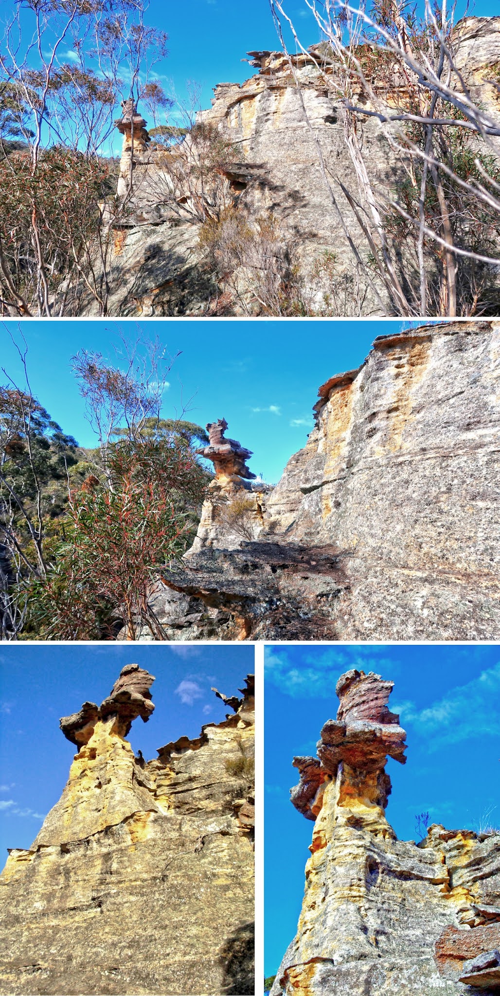
Pagodas - west side of Sunnyside Canyon
We now explore many pagodas
on the west side of Sunnyside Canyon.
9) Climbing up the pagoda
in photo #8's upper pic.
- Upper pic, clockwise from top-left:
Stanley, Lee, WenSheng, ZCC
- Lower pic, left to right:
Lee, ZCC, WenSheng, Stanley

10) A small pagoda.
- Upper pic:
Stanley & ZCC go to climb the small pagoda.
(Photographed from top of pagoda of prev pic)
- Lower pic: ZCC

11) Lee ... at top of another pagoda.

12) Stanley, ZCC, Lee ...
at top of yet another pagoda.

Meeting 3 bushwalkers
13) I don't know these 3 bushwalkers ...
But they recognize me and yell out,
"Are you Paul Ma the blogger ?"
Amazing they can recognize me !!!
- Upper pic: Looking down into Sunnyside Canyon
• Yellow arrows:
The way they climb out of the canyon
Later on, they'll descend back down
into the canyon this way.
They solve for us the puzzle of
how to get down to the canyon ...
We'll copy their route.
- Middle & lower pics:
Zooming into the 3 bushwalkers.

Panorama -
From west side of Sunnyside Canyon
14) This pic and photos #15, #16, #17
form a 360-degree panorama.
- Left side pagoda:
We'll climb it ... Refer to photo #17.
- Right side pagoda:
Climbed in 2018-July (photo #20),
but not today (2020-Dec).

15) (Continuation from the right of previous pic)
The 3 pics below are looking down
at Sunnyside Canyon.
- Upper pic: Downstream ... north-ish
- Middle pic:
(Continuation from the right of the upper pic)
- Lower pic:
(Continuation from the right of the middle pic)
• Upstream ... south-ish
• Yellow arrow:
Later on, We'll climb down into
Sunnyside Canyon this way.
That was how the 3 bushwalkers
climbed out of the canyon in photo #13.

16) (Continuation from the right of previous pic)
- Red arrow: We climbed this pagoda in photo #12.
- Yellow arrow:
Later on, We'll climb down into
Sunnyside Canyon this way.
That was how the 3 bushwalkers
climbed out of the canyon in photo #13.
- Continuation to the right of this pic is photo #17.

A pagoda on west side of Sunnyside Canyon
17) (Continuation from the right of previous pic)
Today (2020-Dec), the last pagoda we climb
on the west side of Sunnyside Canyon.
- Stanley is on the right by himself.
- The rest are our group; and
the bushwalkers of photo #13.
- Continuation to the right of this pic is photo #14,
completing a 360-degree panorama.

18) At top of the pagoda of previous pic.
- Upper pic: Lee ...
On the same rock as Stanley was
in the previous pic
- Lower pic: The 3 bushwalkers of photo #13

19) The 2 pics below are different angles
of the pagoda in photo #17.
(Photographed in 2018-July)
- Upper pic:
The prominent rock here is same as
the one in photos #17 and #18's upper pic.
- Lower pic:
• 2 white arrows: NC, EC
• Rock on right side of the pic is the
prominent rock in the upper pic.

Pagoda climbed in 2018-July
In 2018-July, we went on to climb
the pagoda on the right side of photo #14.
It was the last pagoda we climbed
on the west side of Sunnyside Canyon.
(Not climbed today, 2020-Dec)
20) Looking back at the pagoda
of photos #17, #18, #19.
- Upper pic: The pagoda
- Middle & lower pics:
The rock Stanley & Lee were sitting on
in photos #17 and #18
- Lower left: Photographer: NC
- Lower right: Photographer: CB
Looking down at Sunnyside Canyon
We've climbed down the pagoda of photo #17 ...
21) ... Taking another look at Sunnyside Canyon.
- The 2 pics below and photo #22
form a 180-degree panorama.
- Upper pic: Downstream ... north-ish
- Lower pic:
(Continuation from the right of the upper pic)

22) (Continuation from the right of previous pic)
Scene is upstream of Sunnyside Canyon ...
south-ish
- Yellow arrow:
We'll soon climb down into the canyon
this way.
- 2 white arrows:
Bushwalkers we met in photo #13 ...
They came up from the canyon below.
Now they return the same way.

Sunnyside Canyon
23) We are now down and inside
Sunnyside Canyon.
- Upper left: WenSheng
- Upper right: ZCC
- Lower pic, left to right: Stanley, WenSheng

24) The way forward is along the yellow arrow.
But first, a detour to explore the cliff above.
- Lee is climbing up.
- Below her, left to right: WenSheng, Stanley, ZCC

Exploring a level
above east side of the canyon
25) We've climbed up the cliffs of previous pic,
now facing upstream of the canyon
(ie facing backwards).
- Left to right: Stanley, Lee, ZCC
(WenSheng didn't climb up.)
- Smaller yellow oval:
Pagoda in photos #17, #18, #19
- Larger yellow circle:
Pagoda climbed in 2018-July,
not today (2020-Dec)

26) Facing downstream of the canyon.
- ZCC is the beautiful lady in the 2 pics below.
- Red arrow: ZCC and Stanley
will climb this pagoda later ...
Refer to photo #29.

27) Facing downstream ...
a few steps forward compared to prev pic.
- Red arrow:
ZCC and Stanley will climb this pagoda.
Refer to photo #29.
- White circle:
WenSheng has been waiting there
in the canyon. (He didn't climb up.)
Lee has climbed down to join him.
Stanley, ZCC and I are currently
one level above them.
- Yellow arrows:
Route to red arrow from where
WenSheng and Lee are ... not difficult

Climbing down to Sunnyside Canyon
28) Climbing down from the level of previous pic.
- Upper pic: Stanley
- Lower pic:
ZCC ... photographed from the canyon level
• This cliff face is where
Lee was climbing up in photo #24.
• Large pagoda in the background:
Same pagoda as in photo #20,
and the larger yellow circle in photo #25

A high pagoda
I'm now back at Sunnyside Canyon.
29) Watching ZCC climb up this pagoda
(red arrows of photos #26, #27).
- Lower pic:
• Yellow arrow: The way up, not difficult
- Stanley also made it the top.
But I don't have a photograph of him 😭 ...
The disadvantage of not being a beautiful girl 😊

Continue on Sunnyside Canyon
30) Through this hole to go forward.
- WenSheng

31) The other side of the hole of the previous pic.
- Two Lee's here 😊
- Left side: Lee
- Right side: Lee watching ZCC climbing down
(Earlier on, ZCC dropped her hat on top of
the large rock in the middle of the pic.
As she was there to pick up the hat,
she decided to climb down instead.
It is harder than through the hole,
but not a problem to her.)

32) Sunnyside Canyon.
- Photograph taken at the same spot as prev pic,
facing the opposite side this time
- Yellow arrow: Direction of walk ... downstream
- Left to right: Stanley, WenSheng

33) Through a constriction.
- Left pic: Stanley keeping a watchful eye on Lee
- Right pic: Paul
• Photographer: Lee

34) This small pool is straight after
the constriction of the previous pic
- Yellow arrow: Our route
- Yellow dots: Step on the dots to avoid
slipping into the water.
- Left to right: Lee, ZCC, Stanley, WenSheng

35) Same small pool as previous pic.
- Photograph taken from where
Stanley & WenSheng were in the previous pic
- Yellow arrow: Our route
- Yellow dots: Step on the dots to avoid
slipping into the water.

36) An overhang in the canyon.
- Yellow arrow in both pics below: Our route
- Upper pic: WenSheng
- Lower pic: Same area as upper pic,
facing backwards

37) Tree Fern

38) Through here ... Photographed in 2018-July.
- Upper left: FB

39) Crawl through this hole.
- Upper pic: CB ... Photographed in 2018-July
- Middle pic: The other side of the hole ... ZCC
- Lower pic: A little further away from the hole
in the middle pic
• White oval: This area is the middle pic.

40) Sunnyside Canyon.
- Left to right: Lee, WenSheng, ZCC

41) Sunnyside Canyon is nice !

42) At another small pool.
- ZCC gingerly making her way through
- Yellow oval:
When we first arrived, the log wasn't here.
Thanks to Stanley, Lee and WenSheng,
they hauled it here for ZCC and me.
The log is a great help, as otherwise,
we'll get our feet wet.

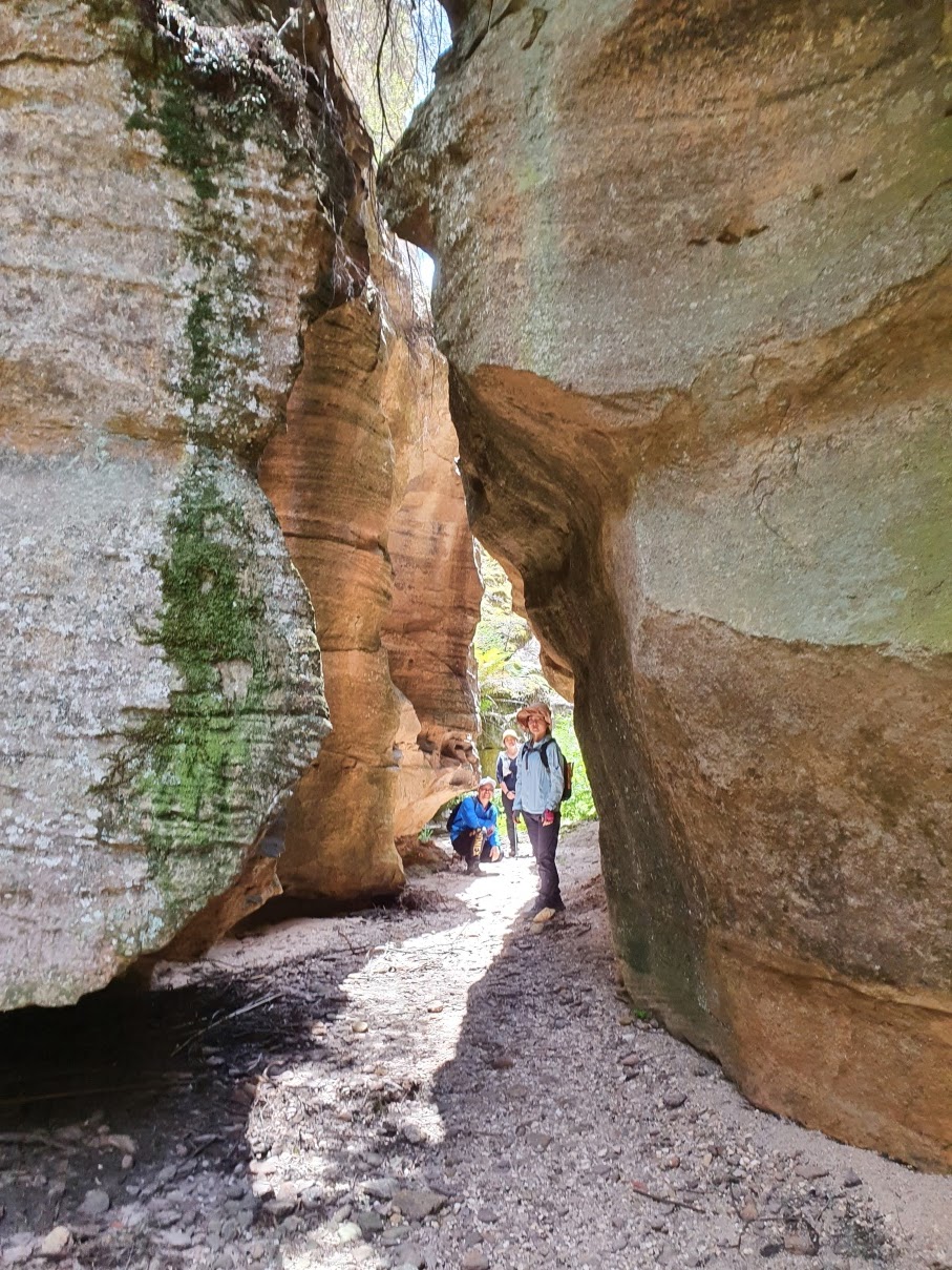
Acoustic Chamber
Immediately after passing through the pool
of previous pic, we arrive at Acoustic Chamber.
Grid Ref: 3537 1338
East side of Sunnyside Canyon
43) A Tree Fern !!!
- Have you ever seen a rectangular block tree trunk
??? !!!
- The background is Acoustic Chamber.
- The lady on the right of the Tree Fern is FM.
(2018-July trip)

44) Acoustic Chamber.
- Upper pic: Tree Fern at lower-right corner
is the one in the previous pic.
- Lower pic:
• Left to right: Paul, WenSheng, ZCC, Lee
• Photographer: Stanley

45) Acoustic Chamber.
- Photographed from the back of the chamber.
- Left to right: Lee, ZCC

46) Looking out from Acoustic Chamber
at a pagoda on the other side (west side)
of Sunnyside Canyon.

47) Acoustic Chamber.
- Amazing how Lee and Stanley (lower pic)
are able to traverse the vertical wall
of the chamber !

48) ZCC is just as deft-footed as Lee & Stanley !
- Photographer: Lee

Sunnyside Canyon -
Downstream of Acoustic Chamber
49) Back at Sunnyside Canyon.
- Upper left: Stanley
• This area is just outside Acoustic Chamber.
- Upper right: WenSheng
- Lower right: WenSheng

50) More canyon photos.
- Yellow arrow: Direction of walk
- Upper left: Stanley
- Upper right:
Lee ... same area as upper-left pic
but facing backwards
- Lower left, left to right: ZCC, Lee
- Lower right, left to right: WenSheng, Stanley

Unnamed cave
Grid Ref: 3537 1347
East side of Sunnyside Canyon
51) At an unnamed cave.
- Not as grand as Acoustic Chamber,
but quite good
- Upper pic: Stanley
- Middle pic, left to right:
Lee, ZCC, Stanley, WenSheng
- Lower pic: Another look at the roof of the cave

52) Lunch at the unnamed cave.
- Left to right: WenSheng, Stanley, ZCC, Lee

53) Looking out from the cave
at a pagoda on the other side (west side)
of Sunnyside Canyon.

Sunnyside Canyon -
Downstream of unnamed cave
54) The canyon is beautiful !
- Yellow arrows in both pics below:
Direction of walk
- Upper pic, left to right: Stanley, Lee, ZCC
- Lower pic:
Facing backwards at the same stretch
of the canyon as the upper pic

55) Out of the constriction of the previous pic.
- Yellow arrows in the 3 pics below:
Direction of walk
- White ovals in upper & lower left pic:
They circle the same mound.
- Lower left, yellow circle:
The constriction in photo #54
- Lower right, top to bottom:
Stanley, Lee, ZCC, WenSheng

Short tunnels
56) Through a short tunnel.
- EC in 2018-July

57) Another short tunnel ... 2018-July.
- This tunnel is close to the short tunnel
of previous pic.
- Upper pic: EC
- Lower pic: Facing backwards into the tunnel

Where one can climb out of the Canyon
58) Just beyond the right side of this pic is a
narrow slot to climb out of the canyon.
- For the time being, we'll keep going forward,
downstream of the canyon.
Then return here later.
- Left to right: WenSheng, ZCC
- White arrow:
Same rock as the white arrows
in photos #69 and #71

Sunnyside Canyon -
The last downstream section
59) Sunnyside Canyon ... nice.
- Upper pic, left to right: ZCC, Lee
- Lower pic: WenSheng

60) Through this hole (2018-July).
- In both pics, NC is the guy
at the far side of the hole.

Sunnyside Canyon - northernmost point
61) Near the northernmost point of
Sunnyside Canyon.
- Top to bottom: Stanley, Lee, ZCC, WenSheng

62) This area is the end of Sunnyside Canyon.
- It is as far north as we are willing to go today.
- Upper pic: Lee
- Lower pic:
A little forward compared to the upper pic

63) (Continuation from the right of previous pic)
We walked along this ledge in 2018-July.
(not today 2020-Dec)

Panorama from ledge
64) 2018-July: 180-degree panorama
from the ledge of previous pic.
(Today 2020-Dec, we turn back earlier ...
at where photos #62 and #63 are taken.)
- Upper pic: Facing backwards
• Red arrow: Cliff of the ledge
• The gap to the right of the red arrow:
Sunnyside Canyon
- Middle pic:
(Continuation from the right of the upper pic)
• 3 red arrows, left to right:
1 Cape Pinnacle
2 Mt Jamison
3 Mt Davidson
- Lower pic:
(Continuation from the right of the middle pic)
• 6 red arrows, left to right:
1 Cape Pinnacle
2 Mt Jamison
3 Mt Davidson
4 Unnamed hill west of Mt Wolgan
5 Mt Wolgan / Donkey Mountain
6 Cliff of the ledge

We didn't walk far along the ledge.
Shortly after the above pics were taken,
we turned around.
Return along Sunnyside Canyon
We are now close to the area in photo #61.
65) Returning along Sunnyside Canyon
towards photo #58. (Around there,
we'll climb out of the canyon.)
- Stanley is on top of a rock.
- Bottom of the pic, left to right:
ZCC, Lee, WenSheng

66) Retracing steps along Sunnyside Canyon.
- ZCC is closest to the camera.
- Others left to right: WenSheng, Stanley, Lee

67) The other side of photo #60.
- Here, on the other side of the hole
is probably ZCC (???)

68) Sunnyside Canyon.
- Upper pic, left to right: ZCC, Lee
- Lower pic:
Same stretch of the canyon
as in photo #59's lower pic ...
but now facing the opposite direction.
• Left to right: Lee, ZCC

Narrow slot ... where
one can climb out of Sunnyside Canyon
Now back at the area where
one can climb out of the canyon.
69) (2018-July)
- Yellow arrow in both pics below:
Points towards a narrow slot
to climb out of the canyon.
- Upper pic: CB
• Red dot:
The lower pic is taken by
standing at the red dot.
• White arrow:
Same rock as the white arrows
in photos #58 and #71
- Lower pic, left to right: CB, Harold, FB, EC, NC

70) Entrance of the narrow slot to climb
out of the canyon.
- Yellow arrow:
Step on this rock first.
It is not easy to climb up,
but not too difficult either.
Easier is to climb up without a backpack,
then later, ask your companions
to lift the backpack up to you.
- White oval:
Ferns growing downwards from
the overhanging rock ... Amazing !
- Upper left pic:
Today, 2020-Dec ... Stanley posing 😊
We don't intend to climb up this way.
- Upper right pic:
2018-July ... We climbed out of the canyon
this way.
• Red oval:
Some logs were placed here.
We stepped on the logs when
hauling ourselves up. They were helpful.
• Top to bottom: FM, Harold, EC, NC
- Lower pic:
Zooming into the downward-growing ferns

71) Scenery photographed from the entrance
of the narrow slot of photo #70.
- White arrow:
Same rock as the white arrows
in photos #58 and #69
- Yellow circle:
Today, 2020-Dec, we'll climb out of the canyon
via a steep slope just beyond the bend there.
(In 2018-July, we climbed out the canyon
via the narrow slot of photo #70.)

Steep slope -
To climb out of Sunnyside Canyon
Grid Ref: 3541 1360 - Bottom of the steep slope
It is actually a steep dry water fall/course.
If it had rained the day before,
then don't climb up this way
as the slope will be wet and slippery.
72) Today, 2020-Dec, it is sunny.
The right side of the slope is dry.
And so we are able to get out of
the canyon this way.
- Yellow arrow: The way up
- Left to right: Lee, WenSheng

73) Steep slope to get out of Sunnyside Canyon.
- Yellow arrow: The way up
- Red arrow:
Pointing to the exit of the narrow slot
(had we climbed up the slot as in photo #70)
- Left to right: ZCC, Stanley, Lee, WenSheng

Narrow slot
74) ZCC just inside the exit of the narrow slot
(red arrow of previous pic)

75) WenSheng leading the charge down the slot
to investigate its entrance at the canyon side.

76) The 2 pics below are taken near where
Stanley was in photo #70's upper left pic.
- Lower pic:
2018-July, EC was helping CB to climb up.

77) Back to near the exit of the slot ...
near photo #74.
- ZCC having fun

78) Lee isn't going to miss out on the fun too ...
She is airborn 😊
- Left pic:
• I am lying on the ground taking photographs.
• Photographer: ZCC
- Right pic, at the bottom, left to right:
WenSheng, Stanley, ZCC

79) Stanley.
- Left pic: Photographer: Lee
- Right pic, at the bottom, left to right:
Lee, WenSheng

Panorama from pagodas -
Overlooking Sunnyside Canyon
After having fun at the narrow slot,
we climb up the pagodas overlooking the canyon.
80) A wonderful view of where we have been.
- This pic and the 3 pics in photo #81
form a 360-degree panorama.
- Also, this pic and photos #82 to #86
form a 270-degree panorama.
- Yellow arrows: Our route earlier in the day
- Red ovals:
The narrow slot is inside there ...
Refer to photos #70; and #74 to #79
- Blue oval:
Where we climbed out of Sunnyside Canyon
via the steep slope ... photos #72 and #73

81) Panorama ... from
pagodas above Sunnyside Canyon.
- Upper pic:
(Continuation from the right of previous pic)
• Scene here is pagodas above
west side of Sunnyside Canyon
• White oval:
Same area as the white oval in photo #82
• White rectangle:
Same area as the upper part of photo #83
- Middle pic:
(Continuation from the right of the upper pic)
• Red arrow:
ZCC will stand on this pagoda
in photo #86's upper pic.
• Cyan arrows: Wolgan River
• White oval: Unnamed hill west of Mt Wolgan
• Left half of this pic: Sunnyside Canyon ...
We walked in there in photos #59 to #68.
Photo #85 zooms into the canyon.
- Lower pic:
(Continuation from the right of the middle pic)
• Red arrow:
This pagoda is also featured in
photo #86's lower pic.
• Left to right: Stanley, ZCC
- Continuation to the right of the lower pic is
photo #80, completing a 360-degree panorama.

82) (Continuation from the right of photo #80)
Looking down at Sunnyside Canyon.
- White oval:
Same area as the white oval
in photo #81's upper pic ...
And so, this pic is also the continuation
down from the white oval there.

83) (Continuation from the right of previous pic)
- Upper pic:
• Upper part:
Pagodas on the west side of
Sunnyside Canyon
• Lower part: Sunnyside Canyon itself
- Lower pic: Beautiful ZCC

84) (A little to the right of photo #83's upper pic)
Sunnyside Canyon.

85) (Continuation from the right of previous pic)
Sunnyside Canyon ...
We walked inside there in photos #59 to #68.
- Scene is the left half of photo #81's middle pic.
- Cyan arrow: Wolgan River
- White oval: Unnamed hill west of Mt Wolgan

86) ZCC climbs these 2 pagodas
on the east side of Sunnyside Canyon.
- Upper pic:
(Continuation from the right of previous pic)
• ZCC: Same as at
red arrow of photo #81's middle pic
- Lower pic:
(Continuation from the right of the upper pic)
• ZCC: Same as at
red arrow of photo #81's lower pic

Leaving pagodas overlooking
Sunnyside Canyon
Time to leave the pagodas overlooking
Sunnyside Canyon.
We now head to Cleft Point,
tip of a finger-like peninsula
north of No 8 Firetrail.
87) WenSheng & Lee climbing down the pagodas
where photos #80 to #86 were taken.

88) Passing these pagodas.

To a lookout
After leaving the pagodas ...
First, go in a easterly direction.
Then northward along a disused road ...
photo #92.
89) The bush is quite open, easy to walk thru.
- Upper pic: Lee
- Lower pic, left to right: WenSheng, Stanley

90) Plenty of burnt Gahnia sieberiana
(Red-fruit Saw-edge) on the ground ...
from the big bushfires of 2020.
- Plant identfication: by Mark Goodson
- ZCC's hand
- Photographer: Lee

91) Camponotus consobrinus (Sugar Ants).
- Lower pic: There is a cocoon at centre of the pic.

92) We come to a disused road not shown
on the NSW LPI map.
- It is actually the continuation of No 8 Firetrail,
and leads northward to a lookout ...
Refer to photo #93.
- (In 2018-July, from around here,
we walked south on the road back to the car.)

Lookout at end of the disused road
93) The disused road of previous pic ends here
at a lookout on a cliff edge.
- 6 red arrows, left to right:
1 Cape Horn
2 Mt Jamison
3 Mt Davidson
4 Blue Rock Gap
5 Unnamed hill
6 Woolpack Rock
- White oval: Unnamed hill west of Mt Wolgan
- Left to right: ZCC, WenSheng

94) 200-degree panorama from the lookout
of previous pic.
- Upper pic:
• 4 red arrows, left to right:
1 Cape Pinnacle
2 Mt McLean
3 Cape Horn
4 Mt Jamison
- Middle pic:
(Continuation from the right of the upper pic)
• 6 red arrows, left to right:
1 Mt Jamison
2 Mt Davidson
3 Blue Rock Gap
4 Unnamed hill
5 Woolpack Rock
6 Unnamed hill, approx 1010 meters
(Behind it is Mt Dawson,
can't be seen from here.)
• 2 white ovals, left to right:
1 Unnamed hill west of Mt Wolgan
2 Mt Wolgan / Donkey Mountain
• Yellow oval: We'll be going there.
• Cyan arrows: Wolgan River
- Lower pic:
Zooming into the right side of the middle pic

To Cleft Point
We continue towards Cleft Point.
95) At another lookout on the cliff edge.
• 5 red arrows, left to right:
1 Cape Pinnacle
2 Mt Jamison
3 Mt Davidson
4 Blue Rock Gap
5 Unnamed hill
• On top of the rock, left to right:
Stanley, ZCC, Lee

96) Panorama from top of the rock of prev pic.
- The scene is similar to photo #94.
- Upper pic:
• 4 red arrows, left to right:
1 Cape Pinnacle
2 Mt McLean
3 Cape Horn
4 Mt Jamison
- Middle pic:
(Continuation from the right of the upper pic)
• 7 red arrows, left to right:
1 Mt Jamison
2 Mt Davidson
3 Blue Rock Gap
4 Unnamed hill
5 Woolpack Rock
6 Unnamed hill, approx 1010 meters
(Behind it is Mt Dawson,
can't be seen from here.)
7 We are going there next,
about 2 minutes walk ...
Refer to photos #97 and #98
• 2 white ovals, left to right:
1 Unnamed hill west of Mt Wolgan
2 Mt Wolgan / Donkey Mountain
• Cyan arrows: Wolgan River

97) This pagoda is the right most red arrow
of the previous pic.
- Upper pic, left to right:
Stanley & WenSheng climbing up
- Right pic: Lee & ZCC leaving

98) Scenery from top of the pagoda of prev pic.
- 3 red arrows, left to right:
1 Unnamed hill, approx 1010 meters
(Behind it is Mt Dawson,
can't be seen from here.)
2 A lookout ... We'll be there ...
photos #100 to #102.
3 Cleft Point, final destination of our trip ...
It is behind this knoll.
- 2 white ovals, left to right:
1 Unnamed hill west of Mt Wolgan
2 Mt Wolgan / Donkey Mountain
- Cyan arrow: Wolgan River

99) Lee finds a jet ski to ride 😊

100) Stanley comes to another lookout
on the cliff edge.
- We are close to Cleft Point.
- 6 red arrows, left to right:
1 Cape Horn
2 Mt McLean
3 Mt Jamison
4 Mt Davidson
5 Blue Rock Gap
6 Unnamed hill

101) At the lookout of previous pic.
- Upper left: Stanley
- Upper right: Lee
- Lower pic: ZCC
• 7 red arrows, left to right:
1 Mt McLean
2 Cape Horn
3 Mt Jamison
4 Mt Davidson
5 Blue Rock Gap
6 Unnamed hill
7 Woolpack Rock
• This pic and the 3 pics in photo #102
form a 360-degree panorama.

102) Panorama from the lookout.
- Upper pic:
(Continuation from the right of previous pic)
• Red arrow: Unnamed hill, approx 1010 meters
(Behind it is Mt Dawson,
can't be seen from here.)
• 2 white ovals, left to right:
1 Unnamed hill west of Mt Wolgan
2 Mt Wolgan / Donkey Mountain
• Cyan arrow: Wolgan River
- Middle pic:
(Continuation from the right of the upper pic)
• South-ish
- Lower pic:
(Continuation from the right of the middle pic)
• 3 red arrows, left to right:
1 We were there ...
Refer to photos #97 and #98.
2 Lookout where the disused road ends ...
Refer to photos #93 and #94.
3 Cape Pinnacle
- Continuation to the right of the lower pic
is photo #101's lower pic,
completing a 360-degree panorama.

Cleft Point
103) Finally, we arrive at Cleft Point ...
just need to climb up.
- Top to bottom: Stanley, ZCC, Lee

104) Scenery from Cleft point.
- Upper pic: ZCC
- Lower pic:
• Yellow arrow:
We were there not long ago ...
Refer to photos #100 and #101.
• Red arrow: Cape Pinnacle
• This pic and the 3 pics in photo #105
form a 360-degree panorama.

105) Panorama from Cleft Point.
- Upper pic:
(Continuation from the right of previous pic)
• 7 red arrows, left to right:
1 Cape Horn
2 Mt McLean
3 Mt Jamison
4 Mt Davidson
5 Blue Rock Gap
6 Unnamed hill
7 Woolpack Rock
• White oval: Unnamed hill west of Mt Wolgan
• Cyan arrows: Wolgan River
- Middle pic:
(Continuation from the right of the upper pic)
• White oval: Mt Wolgan / Donkey Mountain
• Red arrow:
Emirates One&Only Wolgan Valley Resort
towards north-east
• Cyan arrow: Wolgan River
• Cliffs dominating right half of the pic:
Promontory/spur to the north-east / east
of where we are now
- Lower pic:
(Continuation from the right of the middle pic)
• Right half of the pic:
Direction back to the car ... south-ish
- Continuation to the right of the lower pic
is photo #104's lower pic,
completing a 360-degree panorama.

106) Climbing down from Cleft Point.
- Red arrow: Cape Pinnacle
- Left to right: ZCC, Lee, WenSheng, Stanley

107) An interesting cave nearby.

Panorama -
From lookout south-east Cleft Point
About 55 meters south-east of Cleft Point
(photo #104), we come to another lookout
at a cliff edge.
108) This pic and the 3 pics in photo #109
form a 270-degree panorama.
- Red arrow:
Unnamed hill, approx 1010 meters
(Behind it is Mt Dawson,
can't be seen from here.)
- 2 white ovals, left to right:
1 Unnamed hill west of Mt Wolgan
2 Mt Wolgan / Donkey Mountain

109) Panorama.
- Upper pic:
(Continuation from the right of previous pic)
• White arrow:
Emirates One&Only Wolgan Valley Resort
towards north-east
• Valley near the left edge
(left of the white arrow):
Wolgan River flows in there.
- Middle pic:
(Continuation from the right of the upper pic)
- Lower pic:
(Continuation from the right of the middle pic)

And so ends another interesting trip
in Gardens of Stone National Park !
Afterwards, we make a beeline for the car.
Flora
110) Lomatia silaifolia (Crinkle Bush)

111) Lobelia dentata, found in eastern Australia.
- Uncommon, but abundant in some localities
after bushfires
- Habitat is eucalyptus woodland and forest,
often on sandy soils.

112) Epacris reclinata (2018-July).
- Lower pic: Photographer: EC

113) Phyllota squarrosa.

114) Clockwise from top left:
- Goodenia bellidifolia
- Pomax umbellata
- Thysanotus tuberosus (Common Fringe Lily)
• This flower opens on sunny days,
and only lasts for one day.
As this pic is taken in the morning,
the frilly fringes will gradually open up.
Then the flower dies off at night.
• Photographer: Lee
- Platysace lanceolata

115) Clockwise from top left:
- Boronia microphylla (Small-leaved Boronia)
- Isotoma axillaris (Blue Star, Star Flower)
- Leptospermum (arachnoides ???)
- Helichrysum leucopsideum (Satin Everlasting)

116) Clockwise from top-left:
- Leucochrysum graminifolium
(Pagoda Rock Daisy)
Grows only on pagodas around:
• Wollemi Nat Pk
• Gardens of Stone Nat Pk
• Newnes State Forest
• and other surrounding areas
- Solanum vescum's fruit
- Actinotus helianthi (Flannel Flower)
- Solanum vescum
(Gunyang, Narrow-leaved Kangaroo Apple)

Postscript
In 2023-May,
a group of us went to
Acoustic Chamber & Foxs Wedge.
Some interesting pictures are in this link:
https://drive.google.com/file/d/1GjxcMcfYoT46MQTahV0kZRJe1O9fnKC1/view?usp=share_link
No comments:
Post a Comment