Showing posts with label Australia NSW Barrington - Polblue. Show all posts

Wednesday, May 27, 2015

Mt Polblue & Polblue Swamp, NSW, Australia


2015 May: Mt Polblue & Polblue Swamp in Barrington Tops National Park, NSW, Australia

Prolog

My nephew KinSum is in Sydney for a one-week visit. So I take him to Barrington Tops for an outing.
- The morning is spent in the Polblue Swamp area. Afterwards we look for the summit trig in Mt Polblue.
- The afternoon is spent in climbing Prospero.

The Prospero climb is in a separate blog - click on:
    http://mntviews.blogspot.com.au/2015/05/prospero-nsw-australia.html
for the photos and an account of that trip.

Mt Polblue

Mt Polblue, 1577 meters, is the 2nd highest mountain in the Barrington Tops National Park.

It seems hardly anyone ever climbs it. There is only one or two lines on the internet of someone having been there, but no detailed accounts.

3 months ago I went there to climb it ... see my blog http://mntviews.blogspot.com.au/2015/02/brumlow-top-polblue-nsw-australia.html

As this mountain is extremely flat and full of trees/shrubs, at the time, I came to a spot which I thought was the summit. But there was no trig nor cairn. Not convinced that I actually reached the highest point, so after returning home, I did an enquiry on the "Bushwalk Australia" forum:
    http://bushwalk.com/forum/viewtopic.php?f=36&t=19387
It leads to the NSW Land & Property Information website:
    https://maps.six.nsw.gov.au/
Lo and behold, it says there should be a trig at approximately latitude -31.97135, longitude 151.446745. Hence today, I'm here again, determined to find its trig and the true summit.

(There is an uncertainty about the name of Polblue ... Search the internet and you'll find Mt Polblue and Polblue Mountain. On the 1:25,000 scaled Moonan Brook 9134-2S map, it is simple Polblue.)

Polblue Swamp

In the same previous trip to this area 3 months ago, I didn't visit Polblue Swamp ... Now making amends by circumnavigating it. As it is now the end of Autumn, the swamp is a bit quiet. But the vegetation is full of colour ... see photos #1 to #8. Just imagine what it would be like if it is in late Spring with the flowers blooming and wild life in full swing !

Highest peaks in Barrington Tops Plateau

For reference, here are the 3 highest peaks:

#1 : 1586 m  Brumlow Top ... Photos and write up on this climb is in my blog:
http://mntviews.blogspot.com.au/2015/02/brumlow-top-polblue-nsw-australia.html

#2 : 1577 m  Mt Polblue - this trip

#3 : 1556 m  Mt Barrington ... Photos and write up on this climb is in my blog:
http://mntviews.blogspot.com.au/2014/12/mt-barrington-careys-peak-nsw-australia.html

Maps for Mt Polblue & Polblue Swamp

•  Paper map - 1:25,000 scaled Moonan Brook 9134-2S

•  Online - http://www.mud-maps.com/map-store/mud-map-barrington-tops-national-park-ed1/map-226507/preview/

The below map is from 1:25,000 scaled Moonan Brook 9134-2S
The small blue circle near top right hand corner is where we park our car for the Mt Polblue walk.


GPS Tracklog files & Route

The GPX tracklog files of our walks can be downloaded from:
- Polblue Swamp:
https://drive.google.com/file/d/0B877-h5SCJaSekY2N1ljQktXbU0/view?usp=sharing

- Mt Polblue:
https://drive.google.com/file/d/0B877-h5SCJaSOTZiM2Z5MEdzcGM/view?usp=sharing

In summary:
•  At Polblue Picnic Area, circumnavigate Polblue Swamp on the Polblue Swamp Track.
•  Afterwards, park car at Barrington Trail, 210 meters from the junction with Barrington Tops Forest Road.
•  Walk on Barrington Trail until we are at west-south-west of Mt Polblue.
•  Leave trail and bushbash to Mt Polblue summit.
•  Retrace steps to our car.

If you are from Sydney, to drive to Polblue Swamp, best is to go from the west, via Moonan Flat, with about 25 km of unsealed road towards the end.

Timeline & Distance

Polblue Swamp:

09:30  0.0 km  Start walking on the Polblue Swamp Track from the Polblue Picnic Area
10:16  2.8 km  Finish
=================================
Total:  46 mins
           2.8 km  Distance is from Google Earth
           2.9 km  Distance is from Garmin GPS

Mt Polblue:

10:36  0.0 km  Start at Barrington Trail, 210 meters from junction with Barrington Tops Forest Road
10:57  1.8 km  At Nolans Swamp
11:16  3.3 km  Take a rest at a spot west-south-west of Mt Polblue

Put on gaiters

11:36  3.3 km  Resume walking
11:37  3.3 km  Off-track bushbash to Mt Polblue
11:55  3.7 km  At Polblue summit

12:09  3.8 km  Leave Polblue summit
12:18  4.1 km  At Barrington Trail

Take off gaiters

12:22  4.1 km  Resume walking
12:39  5.6 km  At Nolans Swamp
13:00  7.3 km  Finish

=================================

Total:  2 hrs 24 mins
           7.3 km  Distance is from Google Earth
           7.7 km  Distance is from Garmin GPS

Pictures - Polblue Swamp

1)  There is a well maintained track, called Polblue Swamp Track, that circumnavigates Polblue Swamp. As usual with swamps, tussock grass are abound.


2)  Delightful colours of the Polblue swamp.


3)  Delightful colours of the Polblue swamp


4)  Delightful colours of the Polblue swamp


5)  Green moss


6)  Delightful colours of the Polblue swamp


7)  Delightful colours of the Polblue swamp


8)  Delightful colours of the Polblue swamp


9)  Two different mushrooms ~~~ Does any one know their names?


Pictures - Climb Mt Polblue

After the Polblue Swamp walk, we park the car at Barrington Trail, 210 meters from the junction with Barrington Tops Forest Road.

10)  Now walking on Barrington Trail, towards Mt Polblue


11)  On the Barrington Trail, passing Nolans Swamp


12)  Nolans Swamp


13)  We are still on the Barrington Trail, but by the side of Mt Polblue now, and peering into it. If you are wondering where is the summit, it is somewhere inside !  Well, it is extremely flat around here. The summit is probably only a few meters higher than where we are standing. It explains why 3 months ago I couldn't find the summit trig. With all the trees/scrubs, I had no idea where was the highest point - everywhere was of the same height !


14)  About 1.5 km after passing Nolans Swamp is this opening by the side of Barrington Trail (west-south-west of Mt Polblue). It is a disused track with a log blocking the entrance ... probably to prevent 4-wheel drives from barging in. It is here that we now go in to search for the summit and its trig.


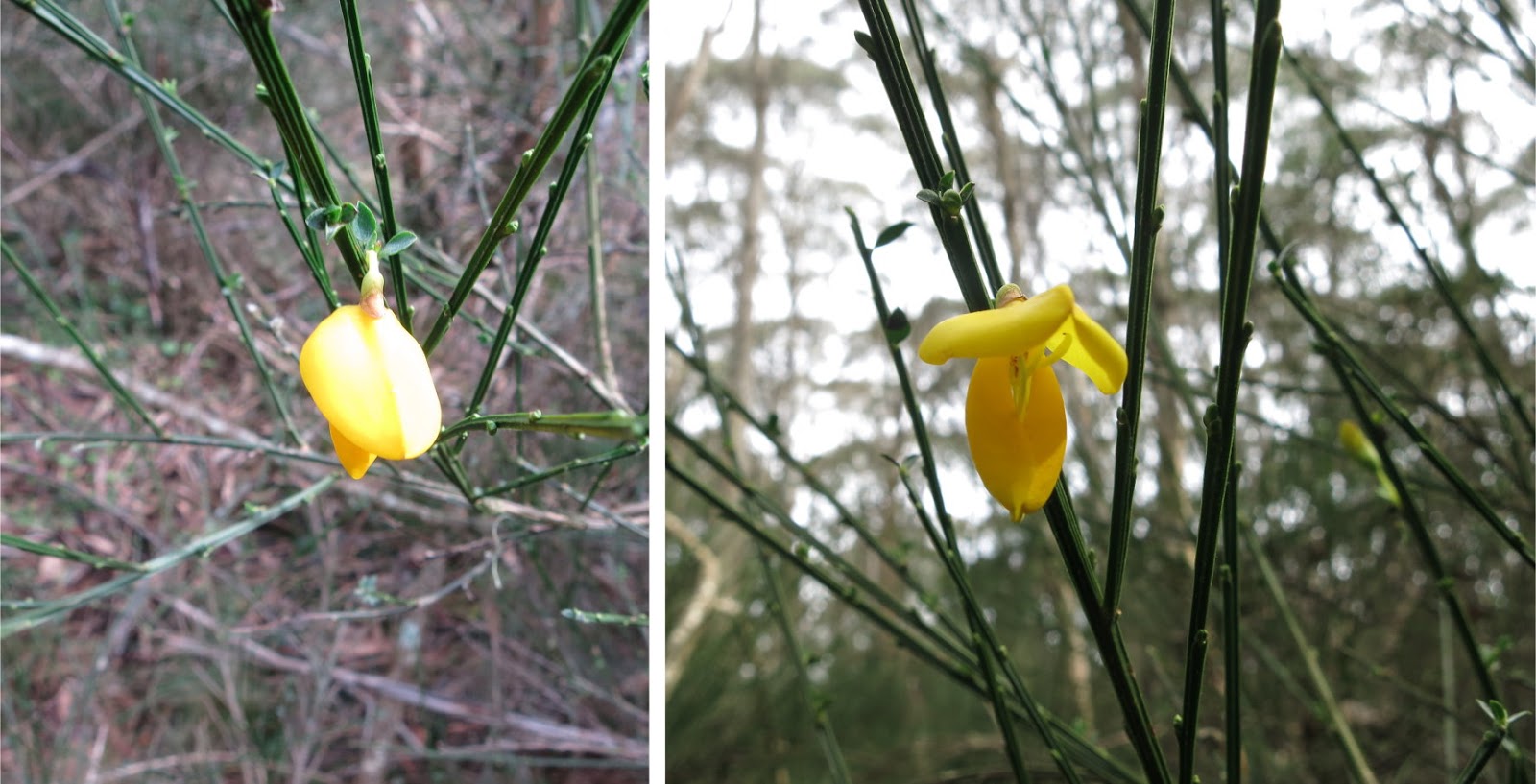
15)  The track soon peters out and it is scrub bashing time. The scrub here is Cytisus scoparius (Scotch Broom). Close up photos of the yellow flowers are in Photo #18.


16)  Finally, the summit trig is in sight. Even though this time I have the coordinates of the summit, but because of the shrubs and trees, it still takes us some searching around to find it.


17)  Mt Polblue summit, 1577 meters, 2nd highest mountain in the Barrington Tops National Park ~~~
With my nephew

There is hardly any information on the internet on this mountain. So, besides us, has anyone else been here recently??? The above two photos maybe the only ones showing you what Mt Polblue summit is like  :-)

By the way, as has been mentioned already, I was here 3 months ago. At the time I reached a spot 50 meters south-west of here and turned back ... well, the place is too flat and has too many trees !  I'm glad I come here again and find the trig and the true summit !

18)  It is the end of Autumn, not much flowers around, except this one ... quite cute looking. The flower points downwards ... the photo on the left is taken at eye level. To take the photo on the right, I have to bend down and point the camera skyward.
Post Script: In the comment section of this blog, Ken said it is Cytisus scoparius (Scotch Broom). In that case it is a perennial leguminous shrub native to western and central Europe, but is declared as a noxious weed in Australia. The plant is hard to eradicate as its seeds can lie dormant for 80 years !!!


19)  After climbing Mt Polblue, we return to Polblue Picnic Area to have lunch. 3 Kookaburras are sitting on a gum tree watching us.


After lunch, we go on to climb Prospero, a nearby hill just outside the National Park. Photos and a write up on that trip is in:
http://mntviews.blogspot.com.au/2015/05/prospero-nsw-australia.html

Monday, February 2, 2015

Brumlow Top & Mt Polblue, NSW, Australia


2015 February: Brumlow Top & Mt Polblue in Barrington Tops National Park, NSW, Australia
                          Day-walk

Brumlow Top & Mt Polblue

Having recently climbed Mt Barrington, 3rd highest mountain in the Barrington Tops Pleateau, you don't expect me to leave the other two higher mountains for long, do you? Hence today David and I climb:
•  Brumlow Top: 1586 m; highest mountain in the Plateau
•  Mt Polblue: 1577 m; 2nd highest

On the web, there is no useful information on these 2 highest points. So, we are almost like exploring virgin territories  :-)

By the way, there is an uncertainty about the name of Polblue ... Search the internet and you'll find Mt Polblue and Polblue Mountain. On the 1:25,000 scaled Moonan Brook 9134-2S map, it is simple Polblue.

On the 3rd highest mountain, Mt Barrington ... Photos and trip report are in my blog:
http://mntviews.blogspot.com.au/2014/12/mt-barrington-careys-peak-nsw-australia.html


Maps

•  Paper maps:
      - 1:25,000 scaled Moonan Brook 9134-2S  for Mt Polblue & Polblue Campground
      - 1:25,000 scaled Barrington Tops 9133-1N  for Brumlow Top

•  Quarantine no-go area (in 2015): Photo #14 ... Scroll forward to see it.

•  Online: http://www.mud-maps.com/map-store/mud-map-barrington-tops-national-park-ed1/map-226507/preview/


In the 1:25,000 map below:
- Blue arrow: Cars can be parked here.
- Blue oval: Watergauge Trail
- The Big Hole is somewhere south along Watergauge Trail.


Camping - Polblue Campground

The night before, we camped out at Polblue Picnic Area & Campground by the side of Barrington Tops Forest Road. It is a nice and large camp site with flush toilets. There is a $10 camping fee per adult - fill out a form and pay the money on the spot.

To reach there from Sydney, you can drive:
- from the west via Moonan Flat; a longer drive with about 25 km of unsealed road towards the end.
- from the east via Gloucester; a shorter drive with about 40 to 50 km of unsealed road towards the end.

Both unsealed roads are ok for 2-wheel drive cars. My preference is the first option - via Moonan Flat.


Polblue Swamp

By the Polblue Picnic Area & Campground is Polblue Swamp which is quite a nice area to visit. 3 months later, I'll circumnavigate the Swamp on the Polblue Swamp Track. Photos and trip report are in my blog: http://mntviews.blogspot.com.au/2015/05/polblue-nsw-australia.html


KML file & Route to Mt Polblue & Brumlow Top

The KML file of our walk can be download from:
https://drive.google.com/file/d/0B877-h5SCJaSMG1SZm1UaUt3SlU/view?usp=sharing


The same KML file superimposed on the 1:25,000 scale map:
- Blue arrow: Cars can be parked here.
- Blue oval: Watergauge Trail
- The Big Hole is somewhere south along Watergauge Trail.


Satellite image


In summary:
•  Start at Barrington Trail off the Barrington Tops Forest Road.
•  Walk on Barrington Trail until we are at west-south-west of Mt Polblue.
•  Leave trail and bushbash to Mt Polblue summit.

•  Retrace steps to Barrington Trail.
•  Walk on Barrington Trail until we are north of Brumlow Top.
•  Leave trail and bushbash to Brumlow Top summit.


Timeline & Distance

06:40   0.0 km  Start at Barrington Trail, 210 meters from junction with Barrington Tops Forest Road
07:24   3.2 km  at west-south-west of Mt Polblue

07:27   3.2 km  Start to bushbash to Mt Polblue summit
07:36   3.4 km  at Mt Polblue false summit (Note: Scroll down to Photo #4 & #5 for details on the true summit.)

07:45   3.5 km  Leave Mt Polblue false summit
07:59   3.7 km  at Barrington Trail
08:53   7.8 km  at north of Brumlow Top

morning tea

09:06   7.8 km  Start to bushbash to Brumlow Top summit
09:23   8.0 km  at Brumlow Top false summit (Too many trees hence we can't see the cairn at the true summit.)

09:30   8.0 km  Leave Brumlow Top false summit and explore around
09:33   8.1 km  at Brumlow Top true summit (We find the cairn !)

Total (one-way): 2 hrs 53 mins;  8.1 km  (Distance is from Google Earth)


The Big Hole & Phytophthora

After climbing Brumlow Top, we intend to visit a place called The Big Hole (no idea what it is, hence keen to check it out). Unfortunately I hadn't done the research properly prior to the trip ... When we reach the Watergauge Trail which will lead us to The Big Hole, we find a locked gate with a sign saying that most of the plateau is under Phytophthora quarantine ... see photo #12 & #14.

Damn! A disappointment, but at least we climbed the 2 highest mountains, and an early day back to Sydney.

(Phytophthora is a water mould that thrives in moist soils. It attacks the roots of plants, causing them to rot. After which the plants die due to their inability to absorb enough water and nutrients. This mould is now found on the Barrington Tops Plateau, hence the quarantine to prevent it from spreading further.)


Pictures

1)  We camped out the night before at Polblue Campground by the side of Barrington Tops Forest Road. This Kookaburra was sitting on a gum tree watching us having dinner.


2)  We are up early in the morning to climb Mt Polblue.
Here, we are walking on the Barrington Trail and are about to enter Nolans Swamp. Mt Polblue is behind the trees on the right edge of the photo.


3)  Mt Polblue is somewhere inside the scrub ... When you are west-south-west of Mt Polblue, it takes about 240 meters of bushbashing to reach the summit (so I thought at the time). The Barrington Tops Plateau is very flat. There, the mountains, if you can call them mountains, don't have the classic pyramid shape. They are merely an area slightly raised above the surroundings.


4)  Although there is no trig or cairn, this small clearing seems to be the summit of Mt Polblue, 1577 m, 2nd highest mountain in the Barrington Tops Plateau.
Like many high points in the Plateau. there is no view ... too flat and too many trees.
Post Script: This is NOT the highest point of Mt Polblue. 3 months late, I am able to find the summit trig and thus reach the real highest point which is 50 meters north-east of here. See photos and trip report in my blog:
http://mntviews.blogspot.com.au/2015/05/polblue-nsw-australia.html


5)  At Mt Polblue summit (so I thought at the time) ~~~
( Post Script: As mentioned earlier. This spot is not the summit.  The true summit is another 50 meters to the north-east.  Photos and trip report are in my blog http://mntviews.blogspot.com.au/2015/05/polblue-nsw-australia.html )


6)  We've come down from Mt Polblue, back on the Barrington Trail to Brumlow Top.


7)  When we are directly north of Brumlow Top, we leave the trail and bushbash for 255 meters towards the summit which is somewhere inside this scrub.


8)  At the summit of Brumlow Top, 1586 m, highest point of the Barrington Tops Plateau.
(We almost miss this cairn ... too many trees! Luckily we explore around and find it !)


9)  A photo to prove we are at the summit of Brumlow Top  :-)


10)  Nearby, a dilapidated rusted sign is hanging onto a tree trunk by one nail. It just seems hardly any one comes here. We are probably the first ones in 2015, and perhaps the last ones in 2015 as well  :-)


11)  The sign says:
          Brumlow Top
          Highest point on the
          Barrington Plateau
          1586 metres
          2003


12)  We've come down from Brumlow Top and are on Watergauge Trail to The Big Hole ... no idea what it is, hence keen to check it out. But we encounter this gate with the sign: "Phytophthora quarantine area. No entry"
Damn! A disappointment, but at least we've climbed the 2 highest mountains, and an early day back to Sydney.


13)  Just inside the gate, there are feral horses. Phytophthora is a water mould that attacks roots of plants causing them to rot. This mould is now found in the Barrington Tops Plateau, hence the purpose of the quarantine area to prevent the mould from spreading further. But these feral horses (and feral pigs too) are not going to observe any quarantine. So what is the point of a quarantine on us hikers??? Sometimes you just wonder at the stupid wisdom of NPWS (National Parks and Wildlife Service).


14)  We found this map on a nearby notice board:
- The pink area is under Phytophthora quarantine. No entry is allowed.
- The green arrow at the top points to Mt Polblue which we climbed early in this morning.
- The other green arrow points to Brumlow Top which we just climbed.
- The red arrow points to the gate (Photo #12) which stops us from going further.
- The blue arrow points to The Big Hole which we are meant to check out.
At the bottom of the above pic is the Corker Trail and Careys Peak Lookout. I hiked around there a month ago. Photos and trip report are in my blog:
http://mntviews.blogspot.com.au/2014/12/mt-barrington-careys-peak-nsw-australia.html


Flora

15)  There are plenty of these pretty daisies on the Plateau. Is it Oxeye Daisy (Leucanthemum vulgare)? ... which is considered a weed in Australia.
The flower closes up at night, and opens in day time:
- The pics on the left hand side are taken at 6:55am. (Sunrise is around 6:20am.)
- The pics in the middle are taken at 7:30am.
- The pic on the right is taken at midday.


16)  These black coloured berries are found on the slope of Brumlow Top. No idea of what are they; and not game enough to taste them  :-)  If you know the name, please let me know. (Could they be Smilax australis (Lawyer Vine)?)


17)  This interesting flower grows close to the ground. I saw them in Mt Bogong (Vic) too. If you know its name, please let me know.


18)  Senecio madagascariensis - Common names: Fireweed, Madagascar groundsel, Madagascar ragwort ~~~
It is a declared noxious weed in some shires; toxic to cattle and horses if eaten ... Refer to this link by NSW Department of Primary Industries: http://weeds.dpi.nsw.gov.au/Weeds/Details/53
(Thanks to the Comment by "bergfee".)


19)  Broad-leaved Pepperbush (Tasmannia purpurascens)


20)  I notice only one single Onopordum acanthium (Scotch or Scottish Thistle, Cotton Thistle).
This photogenic purple plant is native to Europe and Western Asia ...
... from the Iberian Peninsula, east to Kazakhstan, and north to central Scandinavia.
Widely naturalised elsewhere, with especially large populations present in the United States and Australia.
In Australia, it is mostly regarded as a weed.


21)  Wahlenbergia gloriosa (Royal Blue Bell) grows in the wild in the sub-alpine woodland in ACT, south-eastern NSW and Victoria.
It was officially proclaimed the ACT Floral Emblem on 26 May 1982.


Post Script - Mt Polblue

As mentioned earlier, we didn't reach the true summit of Mt Polblue. But 3 months later, I found the summit trig and thus claimed the highest point. Photos and trip report are in my blog:
http://mntviews.blogspot.com.au/2015/05/polblue-nsw-australia.html

Donations are welcome to support the creation of more interesting articles in this blog  :-)

Share