2012 October: Climb Mt Solitary and Ruined Castle, Blue Mountains, NSW, Australia
Prolog:
Having lived in Sydney for so long, it always bugs me that I have not climbed Mt Solitary in the Blue Mountains. From afar, it looks like a long flat table top and just inspires you to want to walk the entire length of it.
Today, Ken wants to do some exercise - to prepare for his Nepal climbing trip coming up in 2 months time. In case you haven't noticed it ... 2 months from now is December, smack bang in Nepal's winter. If you think he is mad to want to go there in winter, well, he agrees with you!
Talking about exercise, I regularly run for half-an-hour at night around the streets near my home. It is a quiet neighbourhood, practically no one in the streets even in day time. One night, rounding a corner, I almost bumped into a ghost, or sleep walker. He scared the shit out of me because I didn't expect to bump into any one, let alone someone wearing a white pajama and stood stiff in the middle of the pedestrian path!!! He stared vacantly straight ahead and didn't even take any notice of me when I was almost on top of him. For the next 10 nights or so, he was there at the same corner, stiff like a scarecrow. Then just as mysteriously as he came onto the scene, he was gone. Ever since then, the nightly run is decidedly boring without seeing him.
I side tracked ... Anyway, we decided on a Mt Solitary traverse - Park my car at Scenic World in Katoomba; then take Ken's car pass Wentworth Falls, pass the abandoned Queen Victoria Hospital, and drive a bit further south to a locked gate on Kedumba Valley Rd. There, we park the car, head towards Mt Solitary, climb it, traverse it, then go to Ruined Castle, then back to my car at Scenic World.
Mt Solitary:
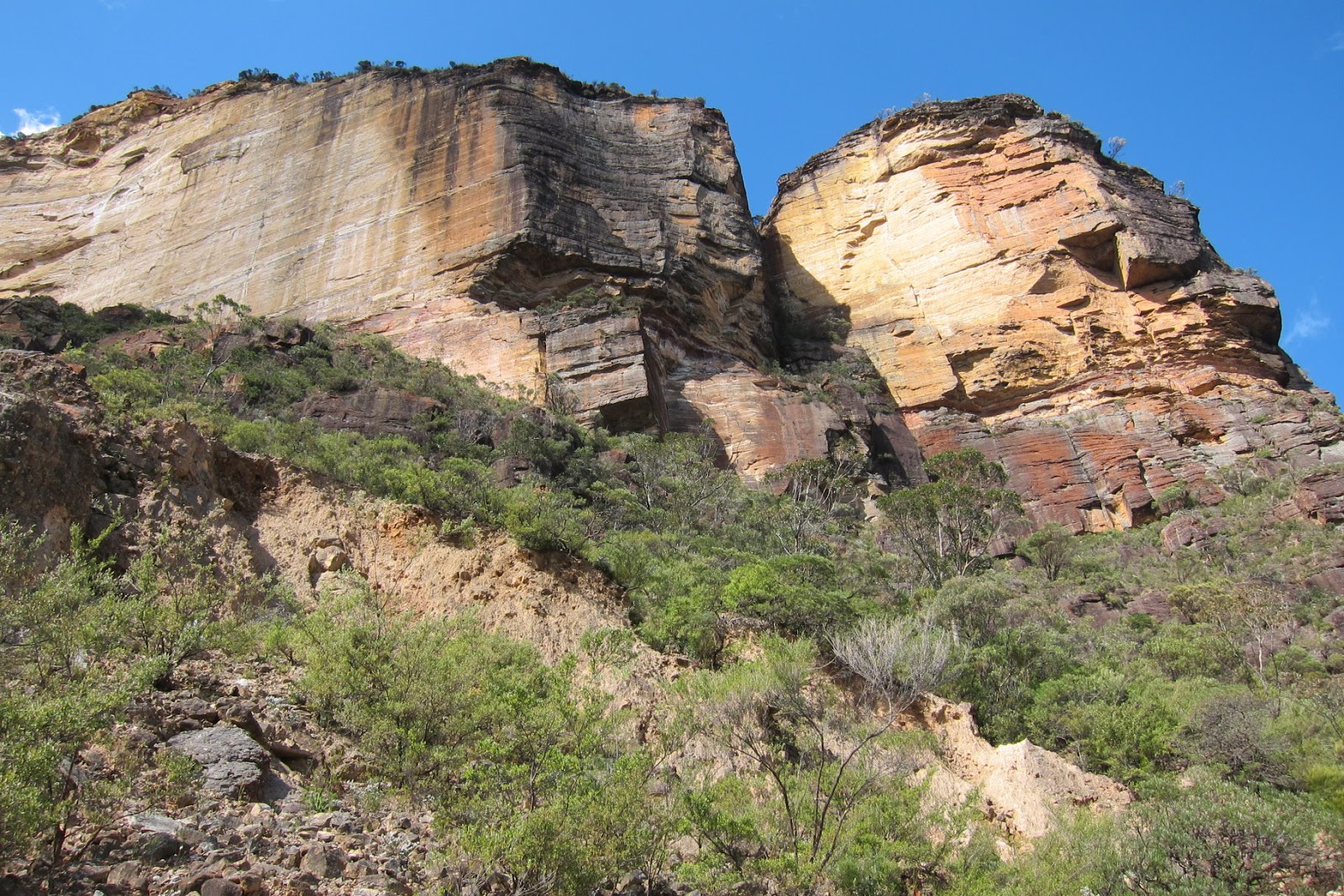
This is it, Mt Solitary. We'll walk the entire length of it, from left to right. (Picture taken towards the end of our walk near Scenic World)

Elevation:
- 775 meters (approx) at The Col, eastern tip of the top of Mt Solitary, left side of the above photo.
- 919 meters at the centre
- 965 meters (approx) near the western end, right side of the above photo
One bad point about this mountain is that there is no cairn marking its highest point. And because of the relative flat topology, you'll walk right pass the summit without noticing it :-(
Maps:
1:25,000 scale topographic maps are:
- 8930-2N Jamison
- 8930-1S Katoomba
GPS tracklog file & route:
Our GPX tracklog file can be downloaded from:
Below is our tracklog, in red, superimposed on the 1:25,000 scale map. We walk from south-east to north-west.
(Notes:
1. The limitation of the blog prevents me from displaying a large sized map here. However you can use your favourite mapping software to better display the above GPX tracklog file on your computer.
2. A clearer map of the east side of The Col is somewhere in this link:
http://mntviews.blogspot.com.au/2017/11/mt-solitary-miners-pass-blue-mts-nsw.html
It is my trip to Mt Solitary & Miners Pass 5 years later in 2017 November.)
The 8 blue arrows point to, from right to left:
1. Starting point of our walk at Kedumba Pass Gate on Kedumba Valley Road
2. Cross Kedumba river here ... Avoid drinking its water. It is supposed to be polluted.
3. The Col, about 775 meters
4. Middle summit of Mt Solitary, 919 meters
5. Lunch
6. Highest point of Mt Solitary, about 965 meters
7. Western end of Mt Solitary
8. Ruined Castle

In summary, our route is:
- Start at Kedumba Pass Gate on Kedumba Valley Road
- Walk on Kedumba Valley Road
- 3.5 km, 36 minutes later, turn into Mt Solitary walking Track
- To The Col, eastern tip of the top of Mt Solitary
- Traverse the top of Mt Solitary
- To Ruined Castle
- Walk on Federal Pass Walking Track
- Climb up Furber Steps
- End at Scenic World carpark at Katoomba
Hiking distance and time:
23 km
8 hrs
Timeline:
08:33 Start walking from a small carpark by Kedumba Pass Gate on Kedumba Valley Road
09:09 At junction of Kedumba Valley Road & foot track to Mt Solitary
09:35 At Kedumba River
10:30 Stop for rest
----- Rest (photo #2)
10:35 Resume walking
11:00 At The Col, eastern tip of the top of Mt Solitary
----- Sign log book
11:07 Leave The Col
11:53 At middle summit, 919 meters
12:01 Leave middle summit
12:25 At lunch spot
----- Lunch
12:51 Leave lunch spot
13:35 At western end of Mt Solitary
14:09 At Ruined Castle
14:15 Leave Ruined Castle
16:30 At Scenic World carpark
-----
Total:
- 7 hrs 57min
- 22.6km Distance is from Google Earth
Description:
Prior to crossing the Kedumba River, it is an easy walk along a firetrail and a foot track. After the crossing, the trail turns into a steep climb to The Col, eastern top of Mt Solitary - just perfect for Ken to get fit.
At The Col, there is log book in a metal box somewhere amongst the rocks. We wrote our names in the book - so now my first ascent to Mt Solitary is preserved in history!
Lunch is a short side trip to a ledge where there is a magnificent view of the Jamison Valley. We can make out the township of Katoomba, but it is a bit far away to be seen clearly.
To get down from the western top, there is a series of steep descends. It only takes a few minutes to get down - compared to the hours that took us to climb up on the eastern side earlier in the morning.
At the detour to Ruined Castle, Ken is a bit tired. So he waits for me while I turn into a trail up a small hill, the top of which is called Ruined Castle. You won't find any castles there, only a pile of large boulders. Nonetheless, it is an interesting place. Many dare devils come here regularly to do some rock climbing.
Then it is back down from Ruined Castle, return to the main trail to meet up with Ken. In case you are looking at the map, from here, the main trail towards Katoomba is called Federal Pass. On our way to the bottom station of Scenic Railway, the Federal Pass winds through an interesting landslide area ... Geez ... you wouldn't want the landslide to happen to you when you are walking through there!!!
The last leg is a 200-meter steep climb up the Furber Steps to Scenic World where my car was parked. I convince Ken to climb the steps instead of taking the railway ... as he needs to get fit for his Nepal trip.
All up, it is a good 8-hr work out on a nice sunny day. To me, the highlight of this trip is seeing the bright red waratahs growing wild. Their red colour stands out so strikingly against the backdrop of the green bush ... see the following photos # 16 and 17.
Pictures:
(There are more pictures of the scenes along the route to The Col in this link:
http://mntviews.blogspot.com.au/2017/11/mt-solitary-miners-pass-blue-mts-nsw.html
It is my trip to Mt Solitary & Miners Pass 5 years later in 2017 November.)
1) In the distance is the eastern top of Mt Solitary.

2) After crossing the Kedumba River, the trail becomes very steep ... so here, mid way up the slope, we take a breather.

3) Looking at The Col, eastern tip of the top of Mt Solitary - in the pic, it is partly obscured by trees ... we'll be climbing to there.

4) Almost at The Col ... just a few more steps ...

5) Made it ! ... at The Col !
The grey metal box at my feet is where the log book is stored.

6) We duly write our names on the log book ... just have to preserve our names for prosperity! :-)

7) 180 degree panoramic view - typical Blue Mountains scenery

8) The highest point in the dark hill is the middle summit of Mt Solitary. We are going to pass over it.

9, 10) At middle summit - no cairn marking this point
By the way, the middle summit is not the highest point of Mt Solitary. But most maps print a triangle sign here to mark this place as Mt Solitary. Anyway, Ken and I take a few photos now just to say we've been here. (The highest point of Mt Solitary is further toward the north-west.)


11) A large termite mound
In the northern part of Australia, termite mounds are often red or orange in colour due to the red earth which are rich in iron content. Mt Solitary is a sandstone plateau, hence the termite mounds here have a yellowish appearance.

12) View towards Ruined Castle which is on the ridge slightly to the left of the centre of this pic - we are going there now.

13) Zooming onto Ruined Castle which is at the top of a hill almost at the dead centre of this pic

14, 15) Steep descend down the west side of Mt Solitary


16, 17) Beautiful red waratahs - This flower is native to the eastern part of Australia. It is more exciting to see them growing wild here than in a garden as the red stands out so much more among the green bush ... don't you think so?


18, 19, 20, 21) I make a side trip to Ruined Castle, which is a pile of large boulders on top of a small hill - an interesting place for people who like rock climbing.


22) Looking back at Mt Solitary from Ruined Castle - It is so satisfying to see that we've walked the entire length of it !

23) On the way to Scenic World is this land slide section. The magnificent cliffs are a hall mark of the Blue Mountains in this area.
24) We reach the bottom station of Scenic Railway (which belongs to Scenic World) and took this picture of the Three Sisters, the main icon of the Blue Mountains.

Post Script
5 years later, in 2017 November, I'll climb Mt Solitary again and descend via Miners Pass. Photos and trip report are in my blog:
http://mntviews.blogspot.com.au/2017/11/mt-solitary-miners-pass-blue-mts-nsw.html
Thanks for sharing . I did the walk from Kings Tableland like you but turned back half way up the east side -had 1 car to return to . Nice description .#
ReplyDeleteHi Paul, thank you so much for detailing your journey here. After doing plenty of research online, reading and committing your route to memory, I did the exact same route as you did in April 2017 by myself. Only hiccup was I've severely underestimated the time it would take me to complete the track - 11 hours instead of 8 hours, just before the sun set at 5.45pm. Let's just say I wasn't really fit, but it was an invaluable experience :)
ReplyDeleteHi Jeff,
DeleteI was younger then. I won't be so fast now :-)
Any time you wish to join me for a walk, just contact me.
Cheers, Paul