2016 September Day-trip
Pantoneys Crown from the north
Gardens of Stone National Park, NSW, Australia
Pantoneys Crown
Google Earth's tilted view of Pantoneys Crown's
western flank, in Gardens of Stone National Park


Pantoneys Crown as seen from Citadel Point,
southern most point of Citadel Spur
(a prominent spur extending south
from Genowlan trig)
(This face of Pantoneys Crown is the same as
previous Google Earth views.)

As you can see, Pantoneys Crown is a mesa,
a free-standing mountain with
a long flat-top plateau.
When you see it from a distance like this,
you just want to climb to its cliffs
and to walk along its entire length.
And so when I heard that CS
from Upper Blue Mountains Bushwalking Club
is organizing a trip to there,
I put my hand up straight away and joined in.
For peak baggers, the summit is about
1030 meters in elevation.
Pantoneys Crown via Baal Bone Point
(from the south)
I'll climb Pantoneys Crown via Baal Bone Point
4 years later in 2020 November.
Photos and trip report are in this link :
http://mntviews.blogspot.com/2020/11/pantoneys-crown-via-baal-bone-point.html
Our group
12 of us:
- CS, leader
- AOB
- Geoff Fox
- GH
- GL
- Harold Thompson
- JD
- JL
- JM
- RS
- Sonya
- and Paul (me)
Maps
- LPI 1:100,000 scaled 8931 Wallerawang
- LPI 1:25,000 scaled 8931-4S Ben Bullen
Below is the relevant part
of the 1:25,000 scaled map.

Starting point of our walk
Starting point of our walk is from
Dominic Della Libera's property,
north of Pantoneys Crown.
His house is at GR 3105 2750.
We park our cars at GR 3108 2743.
As it is Dominic's property,
CS has sought and obtained his permission
to cross his land into Gardens of Stone NP.
To reach Dominic's property from Blue Mountains:
- Through Lithgow.
- Take Castlereagh Highway.
- Pass Lisdale, Cullen Bullen, Ben Bullen.
- At Capertee, turn east into Glen Davis Road.
- Immediately after crossing Crown Creek,
turn south into Crown Station Road.
- Then to Dominic's property.
- Park cars at GR 3108 2743.
GPS tracklog file & Route
The GPX tracklog file of our walk
can be downloaded from:
https://drive.google.com/file/d/0B877-h5SCJaSOGVmSEtMQ2h5dUk/view?usp=sharing
Here is our tracklog, red colour,
superimposed on the 1:25,000 map.
- Starting point of the walk:
Near upper-right-hand corner

Satellite view of our route.
- Starting point of the walk:
Near upper-right-hand corner

A summary of our route is:
1 Start at Dominic's private property.
2 At a cave for morning tea.
3 On top of plateau at north-eastern tip
of Pantoneys Crown.
4 Detour to a lookout (photos #35, #36).
5 At summit.
6 Pass a campsite.
7 At south-western tip of the plateau.
8 Return to campsite for lunch.
9 Retrace steps back to the car.
The numbers 2 to 7 of the above correspond
to the numbers in the satellite view below.

Timeline & Distance
08:43 0.0 km Start at Dominic's private property
10:29 4.1 km Stop at a cave for morning tea
Morning tea
10:45 4.1 km Resume walking
11:19 4.3 km At top of plateau of the north-eastern tip of Pantoneys Crown
11:24 4.3 km Resume walking
11:26 4.4 km At a lookout (photos #35, #36)
11:29 4.4 km Resume walking
11:48 4.8 km At summit of Pantoneys Crown
Take photos. CS logs our entry into the log book.
11:53 4.9 km Resume walking
12:16 5.7 km At a camping area
12:22 5.9 km At south-western tip of Pantoneys Crown
Enjoy the view
12:25 6.0 km Turn around and retrace steps
12:30 6.2 km Stop for lunch at camping area as at 12:16
Lunch
12:52 6.2 km Resume walking
13:25 7.5 km At north-eastern tip of Pantoneys Crown, same spot as at 11:19
13:28 7.5 km Start to climb down
14:05 7.6 km At the same cave where we had morning tea
Afternoon tea
14:10 7.7 km Resume walking
15:37 11.8 km End at Dominic's private property
==============================================
Total: 6 hrs 54 mins
11.8 km Distance is from Google Earth
13.4 km Distance is from Garmin GPS
Weather
Today's weather can be described in one word: cloudy.
And so all my pictures don't have any blue sky in them :-(
On the plus side, the forecast of a shower or two did not eventuate. So we all have a great day.
Pictures - Start at Dominic's property
1) At where we park our cars, GR 3108 2743, by the side of Dominic Della Libera's property ~~~
Dominic's house is at GR 3105 2750, the yellow house to the right of the grey shed.

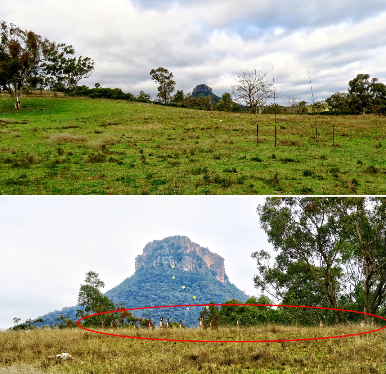
2) Facing Pantoneys Crown, its north-eastern tip, the narrow side of the mountain ~~~
- Lower pic: Zooming into Pantoneys Crown ~~~
• Red oval: A line of kangaroos watching us ... so cute !
• Yellow dots: Our route in the earlier part of the morning
Morning tea will be in a cave just above the highest yellow dot.
After morning tea, it is climbing more or less straight up to the top ... be warned !
3) A pair of donkeys in Dominic's property ~~~
They are probably a male/female pair because they are always together.

To north-eastern tip of Pantoneys Crown
4) There is a semblance of a track to Pantoneys Crown.
- Left to right: 1 CS, 2 GL, 3 Geoff Fox, 4 Harold, 5 JD (back of his head only), 6 AOB, 7 Sonya

5) Does anyone know the name of these mushrooms?

6) Flowers found on the way (Photographer: Harold)

7) We come to an area full of grass trees.

8) Typical trail to Pantoneys Crown ~~~
- CS leading, followed by Geoff Fox, then Harold, JD

9) Now at an area with a nice view of Pantoneys Crown ~~~
- Upper pic: Group photo (Photographer: Geoff Fox)
• Left to right: 1 Harold, 2 GL, 3 Sonya, 4 JL, 5 CS, 6 RS, 7 Paul, 8 AOB, 9 JD, 10 GH
• JM & Geoff Fox are not in the group photo.
- Lower pic:
• Yellow arrows: Our route up the slope
Tip of uppermost arrow: Cave where we'll rest for morning tea
- After morning tea, it is more or less straight up to the top !

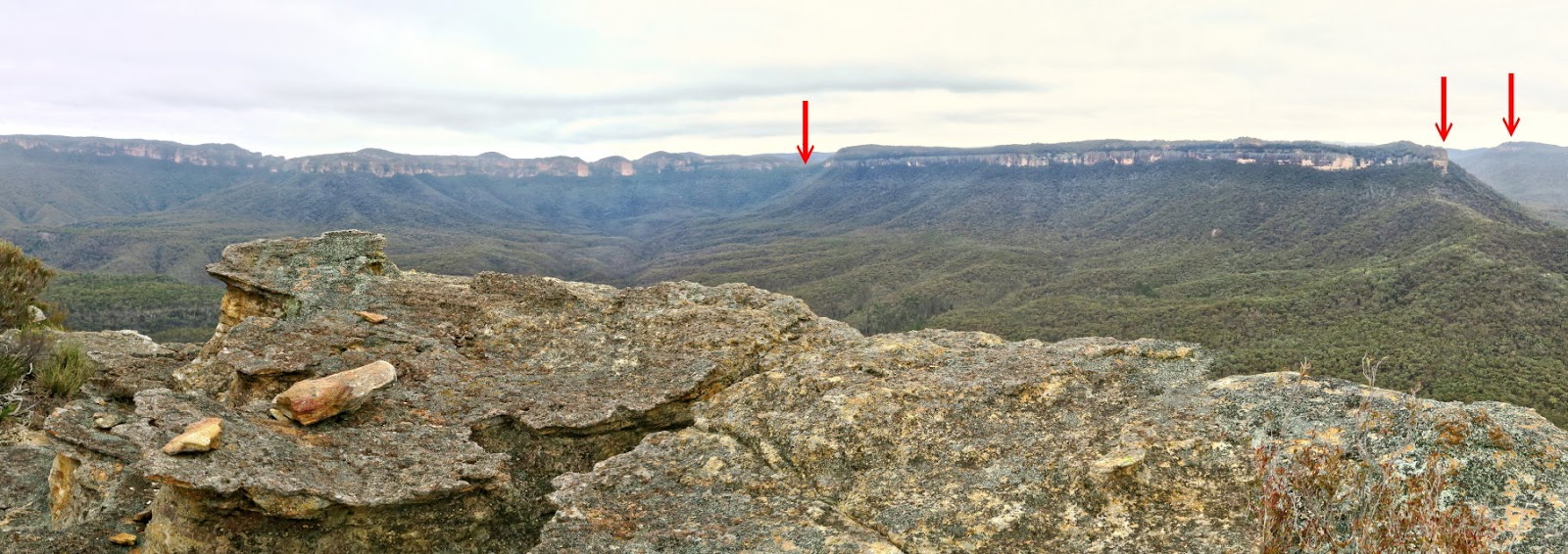
10) Scenery centred towards north-west ~~~
(Picture taken at the same spot as where the previous pic was taken)
- Red arrow: Citadel Point (southernmost point of Genowlan Mountain)
Reference: https://www.bushexplorers.com.au/encyclopaedia/the-citadel
- Highest point on right half of the pic: Genowlan trig, 1040 meters (south-west-ish of Airly Turret)

11) This section is like on the edge of a razor blade. (Photographer: Geoff Fox)
- Upper pic, left to right: CS, JD, JL, GL, GH, Harold, RS, AOB
- Lower pic, left to right: GH, RS, AOB, JM, Paul (Behind Paul is Sonya, blocked by a tree trunk.)

Climbing up north-eastern tip of Pantoneys Crown
12) After the ridge of the previous pic, the climb up the slope of Pantoneys Crown becomes steeper.
- In both pics below: GL is leading, followed by JL.

13) View from north to north-east ~~~
- Red arrow: Gundangaroo & Mt Canobla
- The mountain range on the left half of the pic is in Mugii Murum-Ban State Conservation Area.

14) We are not far now from where we'll have our morning tea.
- Upper pic: AOB and an interesting rock formation
- Lower pic: AOB and a small cave
Both locations are quite close to each other.

Cave where we have morning tea
15) Now approaching a cave (red oval) for morning tea.
After morning tea, it will be a steep climb (yellow arrow) ... hugging the side of the wall of the cave.

16) This is the cave for morning tea.
- Upper pic:
• Yellow arrow: Where we'll continue our climb up the slope of Pantoneys Crown ... it will be steep :-)
• Left to right: GH, Geoff Fox, AOB
- Middle pic: Geoff Fox at right edge, AOB behind him
- Lower pic:
• 3 people at the far end, left to right: Sonya, AOB, Geoff Fox
• In the foreground, left to right; RS, JL, GL, JM
• The sand on the floor should be whitish, but in the pic it shows up as brownish, strange !

17) What animal made these droppings on the cave floor ?

18) (Still at the cave)
Towards north-east ... the right side of photo #13 ~~~
- 2 red arrows, left to right:
1 Gundangaroo & Mt Canobla
2 Point Anderson
- Between Mt Canobla & Point Anderson is Canobla Gap.

Keep climbing up north-eastern tip of Pantoneys Crown
Morning tea is over, the serious climbing starts now :-)
19) Both pics below are of the same scene. It is the yellow arrow of photo #15, ie just to the left of the cave where we had morning tea.
- Left pic: CS is leading.
- Right pic: I am at where CS was in the left pic, looking down at our group.
• Left to right: Harold, AOB, JD, GH, RS, Geoff Fox

20) The next steep climb is here.
Both pics below are of the same cliff ... CS leading, followed by AOB and Harold.
- Yellow arrow: The way up
Once CS reaches the top, he'll let down a climbing tape for the rest of us.
In the afternoon when on the way down, I'll take more photographs of this same area ... Refer to photo #76.

21) At the same spot as where the previous pic was taken; and looking down the mountain

22) I've climbed to the top of the cliff of photo #20, now watching CS setting up a climbing tape.
- 2 red arrows, left to right:
1 Gundangaroo & Mt Canobla
2 Point Anderson ... east-north-east-ish
- Canobla Gap is between Mt Canobla & Point Anderson.

23) Looking down at RS (upper pic) and JL (lower pic) climbing up
(Photographers: Harold and Geoff Fox)

24) Onward we climb ~~~
Harold is at the right edge. In front of him is JL; and in front of her is CS.

25) Now comes the 2nd tape. (Photographer: Harold)
- Geoff Fox (left) and Paul (right) climbing up
On the return trip, I'll take some pictures of this area ... Refer to photo #74.

26) I have climbed up the cliff of previous pic.
- CS watching Harold coming up

27) After the climb of previous pic, for a short while we traverse along a ledge.
- JL is the lady in cyan jacket.

28) Nice scenery along the way ~~~
This one is from north-west to north-east.
- Left arrow: Citadel Point (southernmost point of Genowlan Mountain)
Reference: https://www.bushexplorers.com.au/encyclopaedia/the-citadel
- Right arrow: Gundangaroo & Mt Canobla
- Next high peak to the right of Citadel Point: Genowlan trig, 1040 meters (south-west-ish of Airly Turret)

29) Caves ~~~
- Upper pics: High up on the cliff ... the same cave in both pics.
- Lower pic: A large-ish cave
Left to right: JM, CS, Harold

30) Climbing up towards a short tunnel, the red oval ~~~
- Left pic: JD leading; followed by GH; then Sonya, GL, JL
- Right pic: Geoff Fox leading, followed by GH
On the return trip, I'll take some more pictures of this area ... Refer to photo #73.

31) Through the short tunnel of previous pic ~~~
- Left pic: JL inside the tunnel
- Right pic: Paul emerging out of the tunnel (Photographer: Geoff Fox)

Immediately after emerging out of the tunnel, turn left and climb up a steep narrow slot.
32) JM climbing up the steep narrow slot.
On the return leg, a climbing tape will be let down to help us ... Refer to photo #71.
(To the left of this pic is photo #33.)

On plateau of Pantoneys Crown - north-eastern tip
Finally, end of the steep climbs !!!
We reach the top of the plateau at the north-eastern tip of Pantoneys Crown.
33) (Continuation from the left of previous pic)
- Left to right: GL, JD (just his head), RS, AOB, JL

34) From where we are in the previous pic is this view towards east.
- 2 red arrows, left to right: Canobla Gap, Point Anderson

From now on, we'll walk along the plateau to the summit, then all the way to its south-western tip, a distance of about 1.5 km.
Short detour to a lookout
35) A short detour to this lookout ... quite close to the north-eastern end of the plateau.
- Left to right: JL, Harold (far side), AOB, JD, GH, Sonya, RS, GL, Geoff Fox

36) At the lookout is a 180-degree panorama, from west to north to east.
- Upper pic: Centred towards north-west
• Red arrow: Citadel Point (southernmost point of Genowlan Mountain)
Reference: https://www.bushexplorers.com.au/encyclopaedia/the-citadel
- Lower pic: (Continuation from the right of the upper pic) Centred towards north-east
• 2 red arrows, left to right:
1 Gundangaroo & Mt Canobla
2 Point Anderson
• Canobla Gap is between Mt Canobla & Point Anderson.
• Continuation to the right of this pic is photo #34.

To summit of Pantoneys Crown
Now we walk towards the summit of Pantoneys Crown.
As we are on a plateau, the summit isn't much higher than any where else on the plateau.
37) We pass by this view, towards the west.

38) Does anyone know the name of this flower?

39) Walking along the plateau on top of Pantoneys Crown ~~~
The entire plateau is full of pagoda-like rock formations.

40) Some of the interesting rock formations

41) By now, we are quite close to the summit.
This 180-degree panorama is from north to east to south. (Click on the image to enlarge it.)
- 2 red arrows, left to right:
1 Gundangaroo & Mt Canobla
2 Point Anderson
- Between Mt Canobla & Point Anderson is Canobla Gap.

Summit of Pantoneys Crown
The summit of Pantoneys Crown, about 1030 meters in elevation.
As mentioned already, the top of Pantoneys Crown is a plateau.
Hence the summit is not much higher than the surrounding areas.
42) At the summit ~~~
- Upper pic, right side of the cairn: Geoff Fox is leading; followed by Harold; then GH, JM.
- Middle pic: Sonya
- Lower pic: Paul

43) CS, our leader, took out a tin box from the rock recess on the right side of this pic.
A log book is inside the tin box.
- Lower pic: The Rock recess ... You can make out the dark tin box inside.

From the log book, no one has been here for more than a month ... no entry for the entire 2016 August. But I am aware a group from Sydney University Bushwalking Club had been here on 2016-08-06. Maybe they didn't notice the tin box in the rock recess.
To south-western tip of Pantoneys Crown
After the summit, we keep going towards the south-western tip of the plateau.
44) View towards south-west:
- 2 red arrows: Same 2 pagodas as in photo #47's red arrows
- Yellow arrow: Our route ... Refer to photo #47.
- 4 people nearest to the camera, left to right: Harold, GL, GH, AOB

45) Scenery along the way ~~~
- Upper pic: Harold leading, followed by JL, then Sonya at rear
- Lower pic: Closer to the left side of the upper pic

46) The 3 pics below are of the same rock formation.

47) Walking further along ~~~
- 2 red arrows: Same 2 pagodas as in photo #44's red arrows.

48) The 3 pics below form a 360-degree panorama. It is taken at the same spot as the previous pic.
- Upper pic:
• Red square: The previous pic zooms into this area.
• Left half of this pic: Repeated in photo #69.
- Middle pic: (Continuation from the right of the upper pic)
• Looking back at where we came from
• Left half of this pic: Same scene as photo #68.
- Lower pic: (Continuation from the right of the middle pic)
• Continuation to the right of this pic is the upper pic, completing a 360-degree panorama.

49) Sonya and scenery along the way

50) More pagoda-like rock formations that we pass by.

51) Going down this gap ~~~
- Upper pic, left to right: RS, JM, GH, Harold, GL, Geoff Fox, JL
- Lower pic: Looking back at the gap we just walked down

52) More pagodas ~~~
Left to right: Sonya, JL, Harold, Geoff Fox

53) We come to what looks like a nice camping area, sheltered from the winds. On the way back, we'll have lunch here.
Both pics below are looking back in the direction we came from.
- Red oval: Sort of a waterfall in the gap there ... A picture of it is on the left side of photo #54.
- Blue oval: Same cliff face as the one in photo #54's blue oval.

54) Still at the same place as the previous pic ~~~
- Left pic: A sort of a waterfall ... It is in the gap in the red oval of previous pic.
- Right pic: The scene here is just beyond the right edge of previous pic.
• Blue oval: Same as the blue oval in photo #53's upper pic

55) Still on our way to the south-western tip of Pantoneys Crown ~~~
- 6 people in the front, from left to right: GL, Sonya, JL, RS, JM, Harold
- 3 small figures further away, left to right: AOB, CS, JD

South-western tip of Pantoneys Crown
The final destination of this trip is the south-western tip of Pantoneys Crown.
56) Almost at the tip ... just in front ~~~
- Left to right: GH, JL, RS, JD, AOB (block by a tree trunk), CS, Geoff Fox, Sonya, Harold, JM, GL
That accounts for everyone, except Paul (me) taking this picture :-)

57) At south-western tip of the plateau on top of Pantoneys Crown ~~~
- Upper pic, clockwise from the left: Sonya, JL, AOB, GL, Harold, JM, CS, HB, JD, RS
- Lower pic, left to right: JD, Sonya, Harold, AOB. GL, GH, JM

58) Panorama from the tip ... from south-west to north-west ~~~
It is very windy here, hence Harold is kneeling down and away from the edge of the cliff.
- 3 red arrows, left to right:
1 Baal Bone Point ... south-west
2 Moffitts Pagodas
3 The small village of Ben Bullen is at roughly the tip of the arrow.

59) From south-east to south-west (Continuation from the left of previous pic) ~~~
As it is very wind, I too am at distance from the cliff edge.
- 3 red arrows, left to right:
1 Baal Bone Gap ... south
2 Baal Bone Point ... south-west
3 Moffitts Pagodas
The south-western tip of the plateau is as far as we intend to go in this trip.
Return to camping area (photo #53) for lunch
Time to return to the north-eastern tip, then climb down the plateau and back to our cars.
But first, we'll return to the camping area in photo #53 for lunch.
60) On our way to the camping area ~~~
This place is not far from the south-western tip where the previous few pics were taken.
- CS leading; followed by Sonya; then JM, RS

61) For a short while, we walk along the cliff edge on the eastern side of the plateau.
The view here, from south-east to south-west, is similar to photo #59.
- 3 red arrows, left to right:
1 Baal Bone Gap ... south
2 Baal Bone Point ... south-west
3 Moffitts Pagodas

62) Back at the camping area of photo #53 ~~~
We have lunch here.
Left to right: RS, GL, Geoff Fox, Sonya, Harold

63) Lunch is over, time to leave.
Left to right: Sonya, JM, GH

Return to north-eastern tip of Pantoneys Crown
64) At a cliff edge on the eastern side of the plateau ~~~
- Upper pic, left to right: JM, GH, AOB, JL, GL, Harold
- Lower pic: JD ... looking towards east

65) Passing these pagoda-like rock formations ~~~
- Upper pic:
• Red square: Enlarged in the middle pic
• Red oval: Same as the red oval in the lower pic
- Middle pic: Zooming into the red square of the upper pic
• Red circle: Looks like a face.
- Lower pic, red oval: Same as the red oval in the upper pic

66) Still in the same area as the previous pic ~~~
- Upper pic: This is the left side of previous pic.
- Lower pic: Zooming into the rock formation of the upper pic

67) More interesting pagoda-like rock formations

68) Passing through these pagodas ~~~
The 3 pics below are of the same scene ... and also the same as the left half of photo #48's middle pic.

69) At roughly the same place as where the previous pic was taken, and looking back at where we just came from.
This pic, from south-east to south to west, is the same as the left half of photo #48's upper pic.
- Red square: Same scene as in photo #47
- Yellow dashes: Route to and from south-western tip of Pantoneys Crown.
- 3 red arrows, left to right:
1 Baal Bone Gap ... south
2 Baal Bone Point ... south-west
3 Moffitts Pagodas

70) Still retracing our steps back to north-eastern tip of Pantoneys Crown

At north-eastern tip of Pantoneys Crown
71) We are back at the north-eastern tip of Pantoneys Crown plateau.
- JL (left) and JM (right) climbing down a steep narrow slot
- This place is identical to that in photo #32.

Climbing down Pantoneys Crown
72) Halfway down the narrow slot of the previous pic, turn right into a short tunnel.
- Left pic: JM is turning right into the tunnel.
Behind him is JL. You can still see the white climbing tape trailing behind JL.
- Right pic: The short tunnel ... Another photograph of the tunnel is photo #31.

73) Emerging out of the tunnel ~~~
- Upper pic: I'm at the tunnel exit, looking down at:
• JL (nearest to the camera)
• Geoff Fox in front of her
• JM further down
- Lower pics: I've climb down and looking back at the tunnel (red oval).
• These 2 pics are similar to photo #30.

74) At the 2nd tape ~~~
- Left pic: I'm watching GH going down ... Same scene as in photo #26
- Right pic: I've climbed down and watching GL climbing down ... Same scene as in photo #25

75) Harold sliding down ... behind him is Sonya.
This place is just slightly higher than that in photo #24.

76) Now back at the 1st tape ~~~
- Upper pic: Harold climbing down ... same scene as in photo #23
- Middle & lower pics: I've climbed down, now watching others climbing down ... same scene as in photo #20

Walking back to our cars
Not long after climbing down the cliffs of previous pic, we are back at the cave (photo #16). A rest there for afternoon tea, then it is walking back to our cars at Dominic's property.
77) Plenty of these yellow flowers along the way ... Are they wattles ?

78) Harold (left) and Geoff Fox (right) photographing Hovea

79) Back at Dominic's property
where our cars are parked.

Post Script
- Pantoneys Crown via Baal Bone Point
(from the south)
I'll climb Pantoneys Crown via Baal Bone Point
4 years later in 2020 November.
Photos and trip report are in this link :
http://mntviews.blogspot.com/2020/11/pantoneys-crown-via-baal-bone-point.html
- Pyramid Rocks
Another interesting area in Gardens of Stone NP
is the Pyramid Rocks area,
and the climb up the Great Pyramid.
Photos and trip report are in this link :
http://mntviews.blogspot.com/2019/01/pyramid-rocks-and-caves-above-carne.html
No comments:
Post a Comment