2019 August ... Day-trip
Tesselate Hill
Tessellated Pavements
Unnamed 734-meter hill
(north of Tesselate Hill)
Blue Mountains, NSW, Australia
Prolog
A quick preview of the photos are in this link :
http://onemanadreaming.blogspot.com/2019/07/tessellated-pavements-1.html
Below are 2 representatives:
Tessellated Pavements (at Tesselate Hill)

Unnamed 734-meter hill (north of Tesselate Hill)

I've been to these places before ...
with David Hou 3 weeks ago in 2019 July.
Although it is relatively common to see
rocks with tessellation patterns;
yet it is unusual to see them covering such
a large contiguous area as in Tesselate Hill.
As can be seen from the above photographs,
the areas are quite fascinating.
And so today, I repeat the trip,
to take more photographs ...
solo this time.
Map
LPI 1:25,000 scaled 8931-2S Wollangambe
Map 1) Relevant part of the 1:25,000
topographic map

GPS tracklog file & route
The GPX tracklog file of the walk
can be downloaded from:
https://drive.google.com/file/d/1nDk_TAj_lvNoCT8IHTmC4jnTOawdKMSL/view?usp=sharing
There is a foot track from the carpark to
Tessellated Pavements.
Beyond that, it is all off-track.
Map 2) The same GPS tracklog, in red,
superimposed on the 1:25,000
topographic map.
- Black Oval: Tessellated Pavements
- 5 black arrows, top to bottom:
1 GR 660 978 ...
Northern tip of unnamed 734-meter hill
2 GR 659 974 ...
Unnamed 734-meter hill summit
3 GR 654 969 ... Fork ... Photo #49 and #51
4 GR 652 954 ...
Tesselate Hill summit, 795-meters
5 GR 652 935 ...
Carpark at the end of Mount Irvine Road
(in the village of Mount Irvine)
- 2 purple arrows:
I should have walked along the ridge,
instead of the loopy detour.
Blame it on my wayward GPS
for leading me astray 😊

Map 3) Satellite image.

In summary, the route for today is:
- Start at a carpark at end of Mount Irvine Road
- To Tesselate Hill summit
- To Tessellated Pavements
- Off-track to unnamed 734-meter hill
- To northern tip of the 734-meter hill
- Retrace steps back to carpark
Timeline & Distance
Park my car at GR 652 935,
at the end of Mount Irvine Road
(in the village of Mount Irvine).
09:16 0.0 km Start walking north.
09:54 2.1 km At Tesselate Hill summit,
795 meters.
10:09 2.65km At Tessellated Pavements.
Explore around.
Also morning tea is from 10:50 to 10:58.
10:59 3.75km Leave Tessellated Pavements.
11:47 5.0 km At a fork, GR 654 969, go left.
Photos #49 and #51.
12:09 5.5 km Stop for lunch.
Lunch.
12:51 5.55km Resume walking.
13:04 5.95km At summit of unnamed
734-meter hill.
13:05 5.95km Explore patches of tessellated
rocks around the summit.
13:11 6.15km At the furthest north-west patch
of tessellated rocks.
Then start to head north.
13.44 6.95km At northern tip of the
734-meter hill.
13:49 7.0 km Turn around.
Retrace steps back to the car.
14:24 7.7 km At summit of unnamed
734-meter hill.
15:21 9.0 km At the fork, same spot as at 11:47.
15:43 9.6 km Stop for afternoon tea.
Afternoon tea.
14:49 9.65km Resume walking.
16:11 10.2 km At Tessellated Pavements.
Explore around, again ! 😊
16:19 10.4 km Leave Tessellated Pavements.
17:17 13.05km Back at the car.
================================
Total: 8 hrs 01 min
13.05 km Distance is from Google Earth
Pictures
Most of the pictures in this report are
from today's trip, 2019 August.
A few were from the 2019 July trip with David.
Carpark at trailhead
Mount Irvine Road (in the village of Mount Irvine)
is sealed almost all the way to a gate at
GR 651 934.
Open the gate (close it afterwards)
and drive in for about 200 meters.
You come to a turning circle with a big tree
in the middle.
Park the car around there.
But don't block the road nor the turning circle.
And don't drive pass the turning circle,
as the land after the gate is private property.
1) Carpark and the turning circle at GR 652 935,
at the end of Mount Irvine Road.
- Upper pic:
• White oval: Turning circle for cars
around a big tree
• Yellow arrow: Direction of walk
to Tesselate Hill
- Lower pic:
(Continuation to the right of the upper pic)
• Yellow arrow: Drive to this carpark
from Mount Irvine Road.
• Car: My Toyota Camry

Near trailhead
2) Private house near the trailhead.
- Same house in both pics below

3) Windbreak on left (west) side of the trail.

Foot track to Tesselate Hill
4) Foot track
to Tesselate Hill and Tessellated Pavements.
- Lower pic: David
Photo taken 3 weeks ago in 2019-07

5) Rock formations on the way to Tesselate Hill.

6) The right side of previous pic.

Tesselate Hill summit
The map labels it as "Tesselate" Hill.
Wonder why there is only one "l" in "Tesselate" ???
7) Me ... at Tesselate Hill summit, 795 meters.
- No cairn, no view, too flat,
and too many trees around 😭

From the summit, one can go off-track,
move towards the west (left) a bit
to a few rocky platforms.
But the views are not particularly good ...
again, too many trees.
8) In both pics below:
Unnamed hill towards south-west ...
I'm not going there.
(Pictures taken not far from each other)
- Lower pic: This pic and photo #9
form a 360-degree panorama.

9) The 3 pics below and previous pic form
a 360-degree panorama.
- Upper pic:
(Continuation to the right of previous pic)
• Towards west-ish
- Middle pic:
(Continuation to the right of the upper pic)
• Towards north-ish ... direction I'm heading
(Note: Foot track is not here.
It is further to the east (right);
and can't be seen from here.)
- Lower pic:
(Continuation to the right of the middle pic)
• I detoured along the rocks to where I'm now.
- Continuation to the right of the lower pic
is photo #8's lower pic,
completing a 360-degree panorama.

10) Acacia terminalis (Sunshine wattle)
- Around the summit.

To Tessellated Pavements
Now to Tessellated Pavements.
A foot track goes all the way there.
11) Looking back ...
I just climbed down from there.
- Yellow arrow: Direction of walk

12) Same scene as above pic ...
only a few steps away.
- Yellow arrow: Direction of walk

13) Yellow oval: Tessellated Pavements

Tessellated Pavements
14) About to enter Tessellated Pavements.
- Yellow arrow: Foot track
- This scene is towards north-north-west.

15) Tessellated Pavements.
- A few steps forward compared to previous pic.
- It is a huge area.

16) Tessellated Pavements.
- Upper pic: Left half of previous pic
- Lower pic: A few steps forward compared
to the upper pic

17) Tessellated Pavements.
- 2 red arrows, left to right:
1 Unnamed 734-meter hill ...
I'm heading there soon.
2 Little Tootie
- White oval: Bowens Creek flows
in the valley there.

18) Tessellated Pavements.

19) Tessellated Pavements.
- Yellow ovals in both pics below:
They circle the same area.
- Lower pic: Picture taken closer to the
yellow oval of the upper pic
• Cyan oval: White area inside the oval
is the same as the white areas
in photos #14, #15, #16.

20) Similar scene as previous pic,
slightly different angle.
- Yellow oval: Same as the yellow ovals in
photo #19
- White area above yellow oval:
Same as the white areas
in photos #14, #15, #16

21) The 3 pics below and photo #22
form a 360-degree panorama.
- Also, these pictures are taken a bit closer
to the yellow oval of previous pic.
- Upper pic:
• Red arrow: Unnamed 734-meter hill ...
I'm heading there soon.
• White oval: Bowens Creek flows
in the valley there.
- Middle pic:
(Continuation to the right of the upper pic)
• Red arrow: Little Tootie
- Lower pic:
(Continuation to the right of the lower pic)
• Yellow oval: Same as the yellow ovals
in photos #19, #20
- Continuation to the right of the lower pic is
photo #22.

22) (Continuation to the right of previous pic)
- White oval: There is an engraving of
an aboriginal woman on the ground
to the right of this tree.
- Continuation to the right of this pic is photo #21,
completing a 360-degree panorama.

23) Tree in the white oval of previous pic.
- Nearby is the engraving of an aboriginal woman.
- Also refer to photo #24.

24) Engraving of an aboriginal woman.

25) Aboriginal engravings.
- Upper pic: At the base of the tree
in photos #22 and #23
• White oval: The stone here is the one on
the right of the tree in photo #23.
• Yellow oval: Grinding grooves
- Lower pic: Bowl and grinding grooves ...
Not in the same area as the upper pic

26) A human face.
- Is it natural or ...
- Is it an engraving by the aborigines ?

27) Pot.

28) Tessellated Pavements.

Eastern part of Tessellated Pavements
29) At eastern part of Tessellated Pavements.
- Right yellow oval:
Photo #30's upper pic zooms into this area.
- Left yellow oval:
Photo #30's lower pic zooms into this area.

30) Zooming into parts of the previous pic.
- Upper pic: This is photo #29's right yellow oval.
- Lower pic: This is photo #29's left yellow oval.

31) View from eastern part of
Tessellated Pavements.
- 3 red arrows, left to right:
1 Unnamed 734-meter hill ...
north-north-east ...
I'm heading there soon.
2 Little Tootie ... east-ish
3 Mt Tootie ... east-south-east
- Yellow dots and arrow:
Route to the unnamed 734-meter hill
- White oval: Bowens Creek flows
in the valley there.

Rock cliffs
beneath Tessellated Pavements platform
32) Even the rock cliffs beneath
the Tessellated Pavements platform
are tessellated !

33) Even the rock cliffs beneath
the Tessellated Pavements platform
are tessellated !

Looking back at Tessellated Pavements
I am on my way now to the unnamed
734-meter hill north-ish of Tesselate Hill.
34) Looking back at Tessellated Pavements.
- It is the entire knoll in the background.

To unnamed 734-meter hill
35) Initially, there is a series of flattish rocky areas
on the way to the unnamed 734-meter hill.
- Red arrow: The unnamed 734-meter hill

36) Approaching a lookout.
- It is top of the rocks in the 2 pics below.
- Upper pic:
• Red arrow: Unnamed 734-meter hill
where I'm heading now
• Left white oval: Wollangambe River
• Right white oval: Bowens Creek flows there
- Lower pic: Closer to the lookout
• Red arrow: Unnamed 734-meter hill
where I'm heading now
• Panorama in photos #37 and #38 are taken
from the top of the rock in this pic.

37) Facing the unnamed 734-meter hill
where I'm heading now.
- Picture taken from top of the rock of previous pic
- Yellow dots & arrow: Route to the 734-meter hill
- Left cyan arrow: Where Wollangambe River flows
- Right cyan arrow: Where Bowens Creek flows
- This pic and the 3 pics in photo #38
form a 360-degree panorama.

38) Panorama from top of the rock of photo #36.
- Upper pic:
(Continuation to the right of previous pic)
• Left red arrow: Little Tootie
• Right red arrow: Mt Tootie
- Middle pic:
(Continuation to the right of the upper pic)
• Red arrow: Tesselate Hill
• Yellow oval: Tessellated Pavements ...
It is the large rocky knoll in
the background of photo #34.
- Lower pic:
(Continuation to the right of middle pic)
- Continuation to the right of the lower pic is
photo #37, completing a 360-degree panorama.

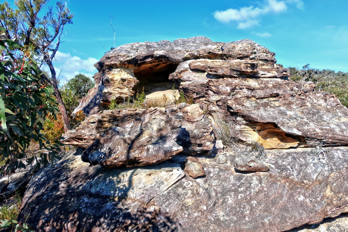
39) An interesting cave with intricate patterns.
- It is directly beneath the rock-cum-lookout
of photo #36.

40) Some rocks not far from the above cave.

41) Come to an area with a good view
of where I'm going.
- Red arrow: Unnamed 734-meter hill
- Yellow arrows: Route to the hill
- Cyan arrow & white oval: Wollangambe River

42) Come to another rocky lookout.
- The ground is like a bunch of bread rolls 😊

43) Looking back at
Tesselate Hill and Tessellated Pavements.
- Photo taken from the rocky lookout of prev pic
- Red arrow: Tesselate Hill
- Yellow oval: Tessellated Pavements
- Yellow arrow: The cave of photo #39
- This pic and the 3 pics in photo #44
form a 360-degree panorama

44) Panorama from the rocky lookout in
photo #42.
- Upper pic:
(Continuation to the right of previous pic)
- Middle pic:
(Continuation to the right of the upper pic)
• Red arrow: Unnamed 734-meter hill
where I'm heading now
• Cyan arrow & white oval at the centre:
Wollangambe River
• White oval at right edge: Bowens Creek
- Lower pic:
(Continuation to the right of middle pic)
• Left red arrow: Little Tootie
• Right red arrow: Mt Tootie
- Continuation to the right of the lower pic is
photo #43, completing a 360-degree panorama.

45) The lookout in photo #42
form the ceiling of this cave.
46) Some rocks further along the way.

47) An interesting rock.
- Upper pic, white oval: Same rock as the lower pic

48) More interesting rocks.
- Upper pic:
• White oval: Same rock as previous pic
• Turquoise oval: Same rock as the lower pic

At a fork
49) We reach this fork.
- Here, you should go left (yellow arrow)
to the unnamed 734-meter hill.
DON'T go right (cyan arrow).
- Rock on right half of the pic: Refer to photo #50.
- Cliffs near left edge: Refer to photo #51.

50) The 2 pics below are the same rock
as the one on the right side of previous pic.

51) Same fork and cliffs as the one
on the left side of photo #49.
- Yellow arrow: Go left along the arrow
to the unnamed 734-meter hill.
- Cyan arrow: Don't take this route.

3 weeks ago, 2019-07, took right fork
3 weeks ago, 2019 July,
David and I took the right fork.
Somewhere along the right fork,
you may be able to climb up the cliffs
from the pictures below.
But simpler is to take the left fork of previous pic.
52) If you take the right fork
(cyan arrow of photos #49 and #51),
you will come to this area:
- Upper left pic: A pink ribbon somewhere
up the cliffs
- Upper right pic: This tunnel is to the immediate
right of the left pic.
- When I climbed up the tunnel,
I could reach the pink ribbon.
It maybe possible for a nimble rock climber
to climb further up to the top of the cliff
(to around photo #57).
But it was beyond a mortal like me.

So I climbed back down the tunnel;
re-traced steps back to the fork
in photos #49 and #51,
then took the left fork, yellow arrow.
53) Interesting beehive-like rock pattern
on the cliffs along the right fork.

This trip, take left fork
In this trip, I take the left fork,
yellow arrow of photos #49 and #51.
54) Interesting rock pattern on the cliffs.

55) Walking along the base of the cliffs.
- Yellow arrows:
Follow the arrows to top of the cliffs
(actually, to top of a ridge), and thence
along the ridge to the 734-meter hill.

56) Looking back.
- Yellow arrows: Direction of walk

On the ridge to unnamed 734-meter hill
Follow the yellow arrows in photo #55
to climb up to the ridge ...
57) Now at the ridge.
- This place is near the top of the cliffs of
photo #52 ... If I were able to climb up there,
I would end up around here.
- 2 red arrows, left to right:
1 Little Tootie, behind the trees
2 Mt Tootie

58) Need to climb over these rocks ... not difficult.

59) An interesting short pillar.

60) Going to climb over these rocks.
- The 2 pics below are of the same scene.
- Lower pic: Picture taken halfway up the rocks.

61) From top of the rock of previous pic,
facing backwards at Tesselate Hill.
- 2 red arrows, left to right:
1 Just behind the ridge is where
my car is parked
2 Summit of Tesselate Hill
- Yellow oval: Tessellated Pavements
- Yellow dots: Route along ridge top to and from
where I'm standing now
- White oval on left edge: Bowens Creek
- White oval on right edge: Wollangambe River
- This pic and the 3 pics in photo #62
form a 360-degree panorama.

62) Panorama from the top of the rock
in photo #60.
- Upper pic:
(Continuation to the right of the previous pic)
• Cyan arrow: Wollangambe River
- Middle pic:
(Continuation to the right of the upper pic)
• Somewhere amongst the trees is
where I'm heading now ...
First, to the rocks in photo #63,
then to the summit of 734-meter hill.
- Lower pic:
(Continuation to the right of the middle pic)
• 2 red arrows, left to right:
1 Little Tootie ... east-south-east-ish
2 Mt Tootie ... south-east
• Cyan arrows: Bowens Creek
- Continuation to the right of the lower pic is
photo #61, completing a 360-degree panorama.

63) More rocks along the ridge
to the unnamed 734-meter hill.
- The 2 pics below are of the same scene.
- Lower pic: I'm halfway up the rocks.

Unnamed 734-meter hill summit
Arrive at the summit of unnamed 734-meter hill.
64) Cairn at summit of the unnamed hill ...
from 2 different angles.
- There is no view from the summit ...
too flat and too many trees.

Tessellated rocks
around 734-meter hill summit
65) Near the summit,
there are many patches of tessellated rocks.
- They do not form as large a contiguous area as
in Tesselate Hill. But still, it is a sight to behold !

66) At another patch of tessellated rocks.
- Lower pic is the upper pic rotated 90 degrees.

67) Moving back from previous pic.
- White rectangle: It is the previous pic.

68) Moving back from previous pic.
- Larger white oval: It is the previous pic.
- Smaller white oval: A fallen branch ...
Same as the ones in the white circles
of photos #69 and #70

69) Moving back again from previous pic.
- The 3 pics below zoom into various parts
of photo #70.
- White circles in upper & middle pics:
Fallen branch, same as the white circles
of photos #68 and #70
- Upper pic: It is lower part of previous pic
- Middle pic:
Continuation to the bottom-left
of the upper pic
- Lower pic:
Continuation to the bottom of the middle pic

70) Overview of photos #67, #68, #69.
- White circle: Fallen branch ...
Same as the white circles in photos #68, #69

71) At another patch of tessellated rocks.
- Lower pic: Zooming into the white oval
of the upper pic

72) More patch of tessellated rocks.

73) Yet another patch of tessellated rocks.
- White ovals in both upper & middle pics:
Same feature from different angles
- Red circles in upper & middle pics:
Same rock viewed from different angles
- 2 lower pics: Same rock as in the red circles

To northern tip of 734-meter hill
Explore towards the northern tip of the hill.
74) Passing these
Tweedledee Tweedledum rocks.

75) A rock / overhang.

Northern tip of 734-meter hill
76) Approaching the northern tip of the hill.
- Upper pic:
• Rocky outcrop in middle of the pic: The tip
• Looming large in the background is
an unnamed 730-meter hill
(height is approximate.)
- Lower pic: Northern tip of the 734-meter hill
(further away from the tip
compared to the upper pic)

77) From the tip,
facing backwards at the ridge I came from.
- Upper pic ... White oval & red arrow:
The lower pic is taken by standing
at the red arrow and facing the white oval.
- Lower pic:
This pic and the 3 pics in photo #78
form a 360-degree panorama.

78) The 3 pic below and the previous pic
form a 360-degree panorama.
- Pictures taken by standing at the red arrow
of photo #77's upper pic.
- Upper pic:
(Continuation to the right of the previous pic)
• Wollangambe River flows from left to right
in the valley horizontally across
the centre of the pic.
- Middle pic:
(Continuation to the right of the upper pic)
• Cyan & blue arrows:
Wollangambe River flowing towards
the blue arrow
• Looming large in the background is
an unnamed 730-meter hill
(height is approximate.)
- Lower pic:
(Continuation to the right of the middle pic)
- Continuation to the right of the lower pic
is photo #77's lower pic,
completing a 360-degree panorama.

79) Near the tip are Banksia serrata trees.

The northern tip of the 734-meter hill
is as far as I go in this trip.
Then it is to retrace steps back to the car.
Flowers
Flowers photographed in this trip.
80) Pimelea linifolia (Slender Rice Flower).

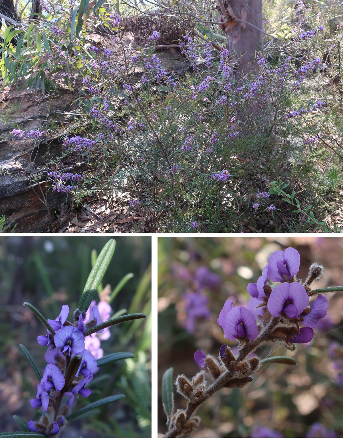
81) Hovea. (Which speicies ?)
82) Lambertia formosa (Mountain Devil)

you
ReplyDeleteYou really pushed out a long way into the sticks here. my family have a place here - and i have been walking out to the Pavements for the last 50 years. in 2020 I visited the same places as in your account. pretty hard going. one day i'd like to follow the ridge line all the lay down to the upper colo.
DeleteThank you for your comments.
DeleteYour proposed walk would be interesting !