2014 November: One day climb of:
- Highest peak (unnamed) on Etheridge Ridge
- Mt Kosciuszko
- North Rams Head
- Rams Head
- South Rams Head
in NSW, Australia
Prolog - A2K peaks, the 33 highest peaks in Australia
I have compiled a list of all the peaks in Australia that are 2000 meters or higher. There are 33 of them, all bunched together in Kosciuszko National Park. I am calling the list Paul Ma's A2K peaks :-)
Rank Name Elev Grid Ref
1 Mt Kosciuszko 2228 m 132 647
2 Mt Townsend 2209 m 128 684
3 Mt Twynam 2196 m 179 716
4 Rams Head 2190 m 128 608
5 Etheridge Ridge 2180 m 140 644
6 Rams Head North 2177 m 137 618
7 Alice Rawson Peak 2167 m 132 692
8 Byatts Camp 2159 m 118 676
9 Abbott Peak 2145 m 122 678
10 Carruthers Peak 2145 m 157 698
11 Tenison Woods Knoll 2136 m 166 719
12 Mt Northcote 2131 m 146 676
13 Little Twynam 2130 m 185 711
14 Muellers Peak 2125 m 138 673
15 Mt Clarke 2110 m 154 672
16 Mt Lee 2105 m 152 688
17 Kangaroo Ridge 2077 m 182 644
18 Mt Tate 2068 m 214 760
19 Gungartan 2068 m 258 835
20 Mt Jagungal 2062 m 248 987
21 Mt Perisher 2054 m 243 697
22 Mt Stilwell 2054 m 187 659
23 South Rams Head 2052 m 116 588
24 Kerries Ridge 2050 m 262 851
25 Little Stilwell 2030 m 190 657
26 Merritts Spur 2030 m 160 626
27 Toolong Range 2025 m 258 988
28 Watsons Crags 2021 m 161 733
29 Back Perisher Mtn 2014 m 247 708
30 Mt Anton 2010 m 191 727
31 The Foxhole 2010 m 198 661
32 Mann Bluff 2005 m 208 754
33 Dicky Cooper Bogong 2003 m 232 832
How the list is compiled:
- If a peak has a name, and is 2000 meters or higher, then include the peak in the list.
- If a range/ridge/spur has a name, and its highest point is 2000 meters plus, then include the highest point.
For more information on the list, including data source, please click on this link:
http://mntviews.blogspot.com.au/p/paul-mas-a2k-peaks.html
Today's climb: Highest peak in Etheridge Ridge + Kosciuszko + 3 Rams Head peaks
Adam & Daniel from Canberra/Queanbeyan region also have the same idea as mine to climb all these 33 A2K peaks. So today, we team up together to climb:
Rank Name Elev Grid Ref
1 Mt Kosciuszko 2228 m 132 647
4 Rams Head 2193 m 128 608
5 Etheridge Ridge 2180 m 140 644
6 Rams Head North 2177 m 137 618
23 South Rams Head 2052 m 116 588
Other A2K climbing trips
Scroll forward to the end of this trip report. There is a list, with links, to other A2K climbing trips that I have done.
Maps
1:100,000 8525 Kosciuszko
1:50,000 Kosciuszko Alpine Area map, 1st edition, by Spatial Vision Innovations Pty Ltd
1:25,000 8525-2S Perisher Valley (As of today, South Rams Head is not correctly placed in this map, I think.)
GPS file & Route
Our GPS file can be downloaded from:
https://drive.google.com/file/d/0B877-h5SCJaSRkNMelM3RWlZd1U/view?usp=sharing
In summary:
- Park car at Dead Horse Gap Carpark.
- Walk on Dead Horse Gap Track.
- Then Koscisuzko Walk - the steel meshed walkway.
- At a point northeast of Lake Cootapatamba, leave steel meshed walkway and go off-track towards highest peak (unnamed) on Etheridge Ridge.
- Then to Mt Kosciuszko.
- Afterwards, retrace Koscisuzko Walk to a point northeast of North Rams Head.
- Leave track and go off-track towards North Rams Head.
- Then to an unnamed peak at south west of North Rams Head. (My Garmin GPS wrongly labelled this one as Rams Head.)
- Then to Rams Head.
- Then to South Rams Head.
- Then bushbash in a roughly south-east-east direction towards Dead Horse Gap Track (but I suggest you head southeast towards the Alpine Way instead ... see Photo #47)
- Walk on Dead Horse Gap Track to Dead Horse Gap Carpark
Timeline & Distance
06:48 0.0 km Start at Dead Horse Gap carpark
08:39 5.0 km Meet up with Kosciuszko Walk (the steel meshed walkway)
09:52 8.6 km Leave Kosciuszko Walk, head towards highest (unamed) peak on Etheridge Ridge
10:00 9.0 km At summit of highest peak (unnamed) on Etheridge Ridge
10:11 9.0 km Leave summit of highest peak on Etheridge Ridge
10:18 9.5 km At highest toilet in Australia
10:21 9.5 km Leave highest toilet in Australia
10:55 11.3 km At Kosciuszko summit
Lunch
11:23 11.4 km Leave Kosciuszko summit
12:15 14.9 km Leave Kosciuszko Walk (the steel meshed walkway), head to North Rams Head
12:38 16.0 km At North Rams Head
13:08 16.1 km Leave North Rams Head
13:53 17.2 km At unnamed peak at south west of North Rams Head
14:00 17.2 km Leave unnamed peak at south west of North Rams Head
14:19 18.0 km At Rams Head
14:28 18.0 km Leave Rams Head
15:41 20.3 km At South Rams Head
15:55 20.3 km Leave South Rams Head
17:18 22.4 km Bushbash to Bogong Creek and cross it
17:26 22.6 km Meet up with Dead Horse Gap Track and an end to bushbashing
Rest
17:41 22.6 km Start walking
18:10 24.0 km At Dead Horse Gap carpark
-------------
Total 24.0 km in 11 hrs 22 mins
(Above distance is from Google Earth. However my Garmin Montana GPS gives 25.3 km)
Pictures
1) The start of the walk is at Dead Horse Gap carpark. First thing is to cross the Alpine Way, then cross this Thredbo River. There is a new foot bridge over the river now ... brings back memories when I was last here in April 2011. At the time, the only way to cross the river was by stepping on stones jutting out of the water. I slipped, and had both feet landed in the river. For the rest of the day, 10 hrs, I walked with wet feet and shoes ... yeeek !!!

2) This is the start of of Dead Horse Gap Track after crossing Thredbo River.

3) Scene on the Dead Horse Gap Track ... The mountain on the left side is South Rams Head. We'll climb it this afternoon. The mountain on the right is unnamed.

4) Today is very windy and beetles are blown around all over the mountain range. Does any one know the name of this beetle?

5) About 2 hours later, the Dead Horse Gap Track gives way to the Kosciuszko Walk trail which, as can be seen in the photo, is a steel meshed walkway.

6) You can see the steel meshed walkway leading towards Mt Kosciuszko (2228m) which is the dome-shaped mountain in the middle of the photo. On its right is the highest peak (unnamed) on Etheridge Ridge at 2180m. We will be climbing both these peaks soon.

7) Zooming onto Mt Kosciuszko ... near the bottom left corner, you can see a person in red walking on the steel meshed walkway.

8) On the way to the foothill of Mt Kosciuszko is this beautifully blue lake called Lake Cootapatamba, the highest named lake in Australia.

9) At a point north east of Lake Cootapatamba, we leave the steel meshed walkway and go off-track towards the highest peak (unnamed) on Etheridge Ridge ... Adam is pointing at it.

10) Getting close to it

11) I am at the top of the highest peak on Etheridge Ridge 2180m, 5th highest peak in Australia.

12) Daniel & Adam.
Mt Kosciuszko is to the left of Daniel

13) We get off the highest peak on Etheridge Ridge which is at the centre of this photo, and are on our way to Mt Kosciuszko. Adam is checking his GPS.

14) The summit of Mt Kosciuszko is in sight (centre of this pic).

15) A few more steps to the summit

16) We make it to the top of Australia - Daniel, Adam and me at 2228 meters. 2 peaks down, 3 more to go. (I must have been here more than 10 times in my life. It is still a joy to be up here again.)

17) View from Kosciuszko summit - Mt Townsend (Australia's 2nd highest mountain) is the left red arrow. Muellers Peak is the right red arrow. Glad to see these old friends again as I've climbed both of them.

18) View from Kosciuszko summit:
- North Rams Head is the dark coloured pyramid at the centre of the pic.
- Towards its right is the partly visible dome-shaped Rams Head (highest peak in the photo).
- The next dark coloured mountain top on the right of Rams Head is South Rams Head.
After lunch, we will be climbing all three of these mountains.

19) Lunch is at the top of Mt Kosciuszko. Afterwards, we retrace the steel meshed walkway to a point northeast of North Rams Head. Then go off-track towards it - centre of this pic.

20) Getting close to North Rams Head ... although the slope on its right side seems gentler, we decide to walk towards the base on the left side instead. Paradoxically, there, we find an easy route up to the summit. On the GPS, this route is on the east side of the mountain.

21) The top of North Rams Head, 2177m, 6th highest peak in Australia, actually consists of 3 mini-peaks - each is a stack of granite boulders. They all seem roughly of the same height. To be sure we are at the top of North Ram's Head, we climb all 3 of them ! Here is me at one of the mini-peaks.

22) Adam & Daniel at North Rams Head summit

23) From the summit looking back at Mt Kosciuszko which is the dome-shaped mountain, and also the highest peak in the photo. To its right, and also the 2nd highest peak in the photo is the unnamed peak on Etheridge Ridge which we climbed this morning.

24) Getting off North Rams Head and heading towards a peak on the south west of North Rams Head. On my Garmin Montana GPS, this peak is wrongly labelled as Rams Head. The real Rams Head is directly behind it and not visible in this pic.

25) Getting close to the peak wrongly labelled as Rams Head in my Garmin Montana GPS.

26) Me at the summit - In the pic, the real Rams Head is behind me.

27) View from the summit - looking back at North Rams Head which we had just climbed.

28) We are heading towards the real Rams Head now.

29) Getting close to Rams Head

30) I am at the top of Rams Head, 2193m, 4th highest peak in Australia. The rocky mountain on the left side of the pic is South Rams Head. We'll be heading there next.

31) Adam at the top of Rams Head

32) Daniel at the top of Rams Head and pointing at Mt Kosciuszko

33) View from Rams Head summit - The rocky pyramid-shaped mountain almost at the centre of this pic is South Rams Head. We'll be heading there next.

34) We are off Rams Head and looking back at it.

35) Heading towards South Rams Head ... On the left-side of the pic is a pile of neatly packed rocks.

36) These neatly packed rocks remind one of the way the South American Incas built their monuments.

37) Walking towards South Rams Head

38) Close to South Rams Head

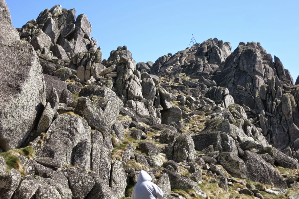
39) Near the peak of South Rams Head, we walk through this interesting valley-like feature with stone walls on both sides ... as if we are in a mythical land. The peak itself is marked by a trig at the centre of this photo. Of all the Snowy Mts peaks, South Rams Head is definitely one of the more interesting peaks to climb.

40) Not far to the peak now
41) I am at the summit of South Rams Head 2052m, ranked 23 of the A2K peaks.

42) Daniel & Adam at South Rams Head summit

43) View from South Rams Head summit - directly north and at the centre of the pic is Mt Kosciuszko. To its right is Rams Head.

44) View from South Rams Head summit - looking down at Thredbo Valley through which the Thredbo River flows. The Alpine Way from Jindabyne to Thredbo also meanders through this valley. Dead Horse Gap Carpark where our car is parked is also somewhere down in the valley.

45) We've climbed down South Rams Head and are looking back at it.

46) We head in a south-east-east direction towards the Dead Horse Gap Track. It is an unpleasant heavy-duty bushbashing to an otherwise magnificent day. In this pic we had just crossed Bogong Creek; and Daniel is climbing up its steep bank.

47) From South Rams Head, instead of bushbashing towards Dead Horse Gap Track like the way we just did, you are probably better off to follow the dotted line in this map towards the Alpine way.

Reflection
- A rewarding clear blue day - we achieved our objectives!
- South Rams Head was the most fascinating climb of the lot ... see Photo #39.
- North Rams Head has 3 mini-peaks at the top - you need to climb up all of them to be sure you've been to the summit :-)
Other A2K climbing trips
• 2017 November
Rank Name Elev Grid Ref
20 Mt Jagungal 2062 m 248 987
27 Toolong Range 2025 m 258 988
Trip report will be written up soon ... whatever that means :-)
In the mean time, if you like to know the details, contact me.
• 2016 December with AB
Rank Name Elev Grid Ref
3 Mt Twynam 2196 m 179 716
11 Tenison Woods Knoll 2136 m 166 719
28 Watsons Crags 2021 m 161 733
30 Mt Anton 2010 m 191 727
Photos and trip report are in my blog:
http://mntviews.blogspot.com.au/2016/12/tenison-woods-knoll-watsons-crags.html
• 2016 December with AB & DN
Rank Name Elev Grid Ref Comment
17 Kangaroo Ridge 2077 m 182 644 Morning
21 Mt Perisher 2054 m 243 697 Afternoon
22 Mt Stilwell 2054 m 187 659 Morning
25 Little Stilwell 2030 m 190 657 Morning
28 Back Perisher Mtn 2014 m 247 708 Afternoon
31 The Foxhole 2010 m 198 661 Morning
Photos and trip reports are in my blog:
- Morning: http://mntviews.blogspot.com.au/2016/12/mt-stilwell-and-kangaroo-ridge.html
- Afternoon: http://mntviews.blogspot.com.au/2016/12/mt-perisher-back-perisher-mtn.html
• 2015 October with RZ
Rank Name Elev Grid Ref
33 Dicky Cooper Bogong 2003 m 232 832
Photos andtrip report are in my blog:
http://mntviews.blogspot.com.au/2015/10/dicky-cooper-bogong-granite-peaks-nsw.html
• 2015 March with AB, DN & Saf
Rank Name Elev Grid Ref
19 Gungartan 2068 m 258 835
24 Kerries Ridge 2050 m 262 851
Photos and trip report are in my blog:
http://mntviews.blogspot.com.au/2015/03/gungartan-kerries-ridge-nsw-australia.html
• 2014 December with AB & DN
Rank Name Elev Grid Ref Comment
1 Mt Kosciuszko 2228 m 132 647
2 Mt Townsend 2209 m 128 684 Abbott Range
7 Alice Rawson Peak 2167 m 132 692 Abbott Range
8 Byatts Camp 2159 m 118 676 Abbott Range
9 Abbott Peak 2145 m 122 678 Abbott Range
10 Carruthers Peak 2145 m 157 698
12 Mt Northcote 2131 m 146 676
wrong Byatts Camp 2110 m 116 671 Abbott Range
15 Mt Clarke 2110 m 154 672
16 Mt Lee 2105 m 152 688
Photos and trip report are in my blog:
http://mntviews.blogspot.com.au/2014/12/lee-northcote-clarke-abbott-range.html
• 2014 November with AB & DN
Rank Name Elev Grid Ref
1 Mt Kosciuszko 2228 m 132 647
4 Rams Head 2193 m 128 608
5 Etheridge Ridge 2180 m 140 644
6 Rams Head North 2177 m 137 618
23 South Rams Head 2052 m 116 588
This trip report :-)
• 2014 April with DH
Rank Name Elev Grid Ref
1 Mt Kosciuszko 2228 m 132 647
2 Mt Townsend 2209 m 128 684
3 Mt Twynam 2196 m 179 716
10 Carruthers Peak 2145 m 157 698
13 Little Twynam 2130 m 185 711
and incidentally bagging the 3 highest peaks of Australia in one day. Photos and trip report are in my blog:
http://mntviews.blogspot.com.au/2014/04/kosciuszko-townsend-twynam-carruthers.html
• 2011 April with RE
Rank Name Elev Grid Ref
1 Mt Kosciuszko 2228 m 132 647
2 Mt Townsend 2209 m 128 684
14 Muellers Peak 2125 m 138 673
Photos and trip report are in my blog:
http://mntviews.blogspot.com.au/2011/04/kosciuszo-muellers-peak-townsend-nsw.html
Great pics!
ReplyDeleteHey I have a question, was it done in April? Is it possible to do it in July without having to wear snow shoes or being specially prepared? Or is it all covered in snow and is pretty icy?
Thank you,
Anton
This trip was in November.
DeleteIn July, the entire mountain will be under snow. You'll need snow shoes or cross-country skis to venture up there.