2017 June: Mulhacén, Spain
Climb it from Hoya del Portillo ... day trip
Mulhacén
Mulhacén, 3479 meters, is the highest mountain in mainland Spain.
It is also the highest mountain in western Europe outside the Alps.

Photograph taken from the slope of Alto del Chorrillo
Reward for reaching its summit is the stunning views. This one is towards a crater lake, Laguna de la Caldera.
After sumitting, you can walk down to the lake ... which is what I did :-)

Prolog
4 months ago in 2017 Feb, I hurt my left knee by jumping off a rock in a bushwalking trip ... how silly of me !
Went to see a doctor ... perhaps he can speed up the recovery.
He produced an X-ray of the knee and said most of the cartilage was worn out ... which explained the pain. "You are old. Short of a knee reconstruction, your climbing/hiking activity is over", those were his words.
Damn doctor ! I didn't mind the advice on the knee, but I hated to hear the word "old" :-)
After 3 months of being cooped up at home, decided to do something ... perhaps a knee brace may help to ease the pain when walking. Bought a "Shock Doctor 875 Ultra Knee Support". It had rigid steel strips on both sides to minimize wobbling of the knees.

Don't you just love my sexy legs !
Lo and behold, the knee brace helped !
Why didn't the doctor advise me to wear it ? Useless doctor !
There were still some niggling pain even with the knee brace on. But at least I could go climbing and hiking again. I was like back from the dead !
This Mulhacén trip was my first hike since the injury 4 months earlier. The knee brace was on for the full 11 hours of the walk. All went well.
The guy who invented it should receive a Nobel Prize !
Post script: I wore the knee brace for a further 6 months until the niggling pain was completely gone.
What about the X-ray that showed the cartilage of the knee was worn out ? Well, as long as I can be out of the house and in the mountains and pain free, who cares ! But now, I am careful about not jumping off a rock again :-)
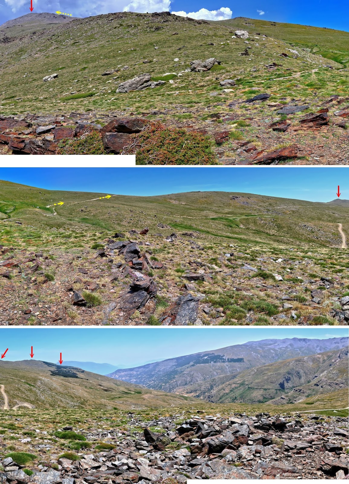
Access to Mulhacén
You can take a shuttle bus from a town called Capileira. The bus will drop you at the base of Mulhacén ... Refer to photo #21 (or #77, same scene). From there, it is 2 to 3 hours walk, one-way, to the summit.
You need to book a seat in advance.
Alternatively, if you have a car, simply:
- Drive to a carpark at Hoya del Portillo. (A locked gate prevents cars from venturing further.)
- Hike to Mulhacén.
- Then drive back to where you came from ... all in a day ... well, a looong day :-)
Which was what I did, from Málaga, my base for the holiday in Spain.
Obviously the walk from Hoya del Portillo, instead of the shuttle bus stop, is much longer. But the scenery is nice all the way, and so it is well worth the effort.
Driving from Capileira to Hoya del Portillo
The road (in red) from the outskirt of Capileira (left side of the map) to the carpark at Hoya del Portillo (black dot):

It is an unsealed road, 10 km, with some potholes here and there, otherwise not bad, and ok for a 2-wheel-drive. My hired car was only a 2WD.
I was up very early in the morning and drove on the road in pitch darkness. Apart from the potholes, I couldn't see much of the surroundings. It was only in the late afternoon on the return trip that I noticed the hairpin turns, the steep gradient, and the precipitous drop down the cliff if the car went off the road :-) Ah, it was an exciting drive to cap off an interesting hike !
By the way, the road (in red) is labelled as:
- Camino de la Sierra in Google Maps
- GR-411 in AllTrails map
- GR-411a in OpenStreetMap ... I'll use "GR-411a" in this report.
Maps
The maps here are from AllTrails.
Map 1)
- Blue box: Refer to Map 2
- Mulhacén summit: Labelled at top of the map as "Pico de Mulhacén"
- 5 red arrows, top to bottom:
1 Refugio Poqueira
2 Big cairn
3 Shuttle bus stop
4 Alto del Chorrillo
5 Trailhead ... carpark at Hoya del Portillo, by a locked gate on an unsealed road called GR-411a

Map 2) Blue box of above map ~~~
- 5 red arrows, clockwise from left:
1 Pico de Loma Pelada, 3183 meters
2 Puntal de Laguna Larga, 3182 meters
3 Puntal de la Caldera, 3222 meters
4 Mulhacén, 3479 meters
5 Mulhacén II, also known as Falso Mulhacén, 3362 meters
- 3 blue arrows, left to right:
1 Laguna de la Caldera
2 Refugio-Vivac La Caldera (Refugio de la Caldera)
3 Laguna de la Caldereta

GPS tracklog files & route
The GPX tracklog files of the climb can be downloaded from:
- From trailhead to Mulhacén summit:
https://drive.google.com/open?id=1gUia4CYb_uwko4C4z5hi68ma340R4J7G
- From summit back to the trailhead:
https://drive.google.com/open?id=1s3AkbIlX6tg3i8kdsmFUsX-cEnhvyuZb
Map 3) The same GPS tracklogs are drawn in red in the AllTrails map below.
- Upper circuit: counter-clockwise
- Lower circuit: clockwise

Map 4) Blue box of above map ~~~
- Black dot: Mulhacén summit

Map 5) Satellite image of Map 3 ~~~
- Black dot: Mulhacén summit
- Trailhead: Bottom of the image

In summary, the route for today's trip is:
- Start at carpark at Hoya del Portillo, by a locked gate on an unsealed road, called GR-411a
- To Puerto Molino
- To Prado Llano
- To a rocky lookout at Mirador de Trevélez
- To Alto del Chorrillo
- At shuttle bus stop
- To Mulhacén II, also known as Falso Mulhacén
- To Mulhacén summit
- To Refugio-Vivac La Caldera (Refugio de la Caldera)
- Descend along Rio Mulhacén
- To Refugio Poqueira
- To big cairn on an unnamed knoll
- At shuttle bus stop
- Along GR-411a back to Puerto Molino
- Back at carpark
Timeline & Distance
06:42 0.0 km Start walking from Hoya del Portillo carpark
07:12 1.4 km At Puerto Molino
07:16 1.5 km Leave Puerto Molino
07:48 2.8 km At Prado Llano
07:49 2.8 km Leave Prado Llano
08:36 5.6 km Leave GR-411a; off-track to Mirador de Trevélez
08:43 6.0 km At a rocky lookout at Mirador de Trevélez
Morning tea
08:50 6.0 km Leave Mirador de Trevélez
09:04 6.7 km At Alto del Chorrillo
09:09 6.8 km Leave Alto del Chorrillo
09:16 7.3 km At shuttle bus stop for people climbing Mulhacén
10:19 9.8 km At a lookout with some ruins
Short rest
10:23 9.8 km Resume walking
11:19 11.3 km At Mulhacén II, also known as Falso Mulhacén
Lunch
11:45 11.4 km Resume walking
12:16 12.4 km At Mulhacén summit
Explore around the summit
12:40 12.6 km Leave Mulhacén summit
13:29 14.2 km At Refugio-Vivac La Caldera (Refugio de la Caldera)
Afternoon tea #1
13:46 14.3 km Leave Refugio-Vivac La Caldera
13:56 14.7 km Get off dirt road to walk along Mulhacén River
15:10 18.0 km At Refugio Poqueira
Afternoon tea #2
15:21 18.2 km Leave Refugio Poqueira
15:55 19.7 km At a big cairn on top of a small unnamed knoll
16:01 19.7 km Resume walking
16:21 20.7 km At shuttle bus stop for people climbing Mulhacén (same spot as at 09:16)
16:29 21.4 km At where I went off track to Mirador de Trevélez at 08:36
17:34 25.8 km At Puerto Molino
18:02 27.3 km End at Hoya del Portillo carpark
==============================================
Total: 11 hrs 20 mins at leisurely pace
For you, less than 10 hours should be sufficient. I was slow due to lack of fitness.
27.3 km Distance is from Google Earth
29.2 km Distance is from Garmin GPS
Pictures - Carpark at Hoya del Portillo
The start of the hike to Mulhacén is a carpark at Hoya del Portillo.
- An unsealed road, called GR-411a, passes through the carpark.
- A locked gate prevents private cars from going further.
- However buses taking hikers to climb Mulhacén can travel further up. Bus stop is in photos #21 and #77.
1) Carpark at Hoya del Portillo ~~~
- Upper pic: Early in the morning at 6:40am. No one is here yet :-)
• Black car: Skoda Octavia, a hired car during my holiday in Spain.
• Blue arrow: Foot track to Mulhacén
• Red arrow: Guard house
• Cyan Arrow: The unsealed road, GR-411a, continues beyond the locked gate.
- Middle pic: Guard house (Photo taken in late afternoon, after climbing Mulhacén)
• Blue arrows: Foot track to Mulhacén
- Lower pic: Back of guard house (Photo taken in late afternoon, after climbing Mulhacén)
• Blue arrow: Foot track to Mulhacén
• Red circle on right edge: Skoda Octavia, my hired car

Foot track to Puerto Molina
2) Initially, the foot track is through a forest ~~~
- Yellow arrows: Foot track to Puerto Molina
- Upper pic: Sign nailed to tree on the left points the way to Puerto Molina.
- Middle pic: Picture taken in late afternoon on the return leg.

3) Small yellow flowers along foot track

4) I am now above the tree line. Here are some of the scenery.
- Upper pic: There are cairns at regular intervals, all the way to Mulhacén.
- Lower pic: Facing backwards ... towards south-south-west ~~~
• Most junctions have signposts, like the one here.
• 3 red horizontal arrows, top to bottom:
1 Points to: Área recreativa 1.5 km Hoya del Portillo ... Where my car is parked
2 Points to: Refugio Poqueira 7 km ... Refer to photos #68 and #70.
3 Points to: Mirador Puerto Molina 250 m ... Where I'm going now
• 3 red vertical arrows, left to right:
1 Sierra de Lújar, 1878 meters
2 Cerro de la Cola del Pino
3 Dam on Rio Guadalfeo ... The dam is called Presa de Rules.
• Yellow arrows: Direction of walk to Puerto Molina

Puerto Molina
Puerto Molina is a ruin with some information boards on the history, geology, plants and animals of the region.
5) The ruins of Puerto Molina ~~~
- Upper pic: Approaching Puerto Molina
• Blue arrow: Same feature as the blue arrow in photo #6's middle pic
- Middle pic: At the stone wall in the middle of the upper pic
- Lower pic: Another part of the ruin

6) Leaving Puerto Molina ~~~
- Upper pic: This is the right side of the ruins in the middle pic.
- Middle pic: Leaving Puerto Molina, and looking back at it.
• Blue arrow: Same feature as the blue arrow in photo #5's upper pic
• Red arrow: Dam on Rio Guadalfeo ... The dam is called Presa de Rules.
- Lower pic: Further away from Puerto Molina, and looking back at it.
• Red arrow: Presa de Rules on Rio Guadalfeo
• Yellow arrows: Foot track towards Mulhacén
• Cyan ovals: Information boards
- Some more pictures of the same area are in photo #81, photographed on the return leg.

7) Flowers growing on the grounds of Puerto Molina

To Prado Llano
8) Scenery on the way to Prado Llano ~~~
- Upper pic: A bunch of rocks ... north-ish
• Yellow arrow: Foot track to Prado Llano
- Lower pic: Facing backwards ... towards south-south-west ~~~
• 3 red arrows, left to right:
1 Sierra de Lújar, 1878 meters
2 Cerro de la Cola del Pino
3 Dam on Rio Guadalfeo ... The dam is called Presa de Rules.
• Yellow arrows: Foot track to Prado Llano

9) Grass and flowers

Prado Llano
10) Approaching Prado Llano, 2578 meters ~~~
- Right red arrow: Concrete cairn at the summit of Prado Llano
- Left red arrow: 2 peaks in the same line of sight on the crater rim of a lake called Laguna de la Caldera. The one in front is Pico de Loma Pelada, 3183 meters. It blocks the view to the one behind, Puntal de Laguna Larga, 3182 meters.

11) View from the summit cairn of Prado Llano ... Not sure whether this a ruin or a wind-break built more recently ~~~
- Upper pic: 5 red arrows, left to right:
1 Pico del Veleta, 3390 meters
2 Cerro de los Machos, 3329 meters
3 Pico de Loma Pelada, 3183 meters
4 Puntal de la Caldera, 3222 meters
5 Mulhacén (Actually Mulhacén II, 3362 meters ... Mulhacén summit is behind it; can't be seen from here.)
- Lower pic: 2 red arrows, left to right:
1 Pico del Veleta, 3390 meters
2 Cerro de los Machos, 3329 meters

12) Panorama ... pictures taken from the ruin (or wind-break) of the previous pic ~~~
- Upper pic:
- Middle pic: (Continuation to the right of the upper pic)
• Centre of the pic is the concrete cairn at top of Prado Llano
• Red arrow: Sierra de Lújar, 1878 meters
• Red oval: My shadow
• Yellow arrows: Foot track I walked on to reach here
- Lower pic: (Continuation to the right of the middle pic)
• 4 red arrows, left to right:
1 Pico del Veleta, 3390 meters
2 Cerro de los Machos, 3329 meters
3 Pico de Loma Pelada, 3183 meters
4 Puntal de la Caldera, 3222 meters
- Continuation to the right of the lower pic is photo #13.

13) (Continuation to the right of previous pic)
- 6 red arrows, left to right:
1 Puntal de la Caldera, 3222 meters
2 Mulhacén (Actually Mulhacén II, 3362 meters ... Mulhacén summit is behind it; can't be seen from here.)
3 Alto del Chorrillo, 2721 meters
4 Highest point near Mirador de Trevélez
5 & 6 Unnamed peaks (Unnamed on the maps I have access to)
I will not be climbing them. The foot track doesn't go over their summits.
- Yellow dot & arrows: Foot track I'll be walking on
- This pic and the 3 pics in photo #12 form a 360-degree panorama (apart from a small gap between here and photo #12's upper pic).

To Mirador de Trevélez
14) I am over the yellow dot of previous pic.
- 5 red arrows, left to right:
1 Pico de Loma Pelada, 3183 meters
2 Puntal de la Caldera, 3222 meters
3 Mulhacén (Actually Mulhacén II, 3362 meters ... Mulhacén summit is behind it; can't be seen from here.)
4 Alto del Chorrillo, 2721 meters
5 Highest point near Mirador de Trevélez
- Yellow arrows: Foot track I'll be walking on
- You can see a unsealed road starting on the right edge, then continues on the left side of the 2 vertical yellow arrows. It is GR-411a.

15) (A few more minutes forward compared to previous pic)
The 2 pics below form a 200-degree panorama.
- Upper pic:
• Red arrow: Facing backwards at an unnamed hill ... same as the 5th red arrow (from the left) of photo #13.
A topographic map gives its elevation as 2617 meters.
I didn't climb it. The foot track doesn't go over its summit.
• White oval: My shadow
• Yellow arrows: Foot track I walked on.
• Yellow dot: Same as the yellow dot in photo #13. The foot track goes over it.
- Lower pic: (Continuation to the right of the upper pic)
• 7 red arrows, left to right:
1 Pico del Veleta, 3390 meters
2 Cerro de los Machos, 3329 meters
3 Pico de Loma Pelada, 3183 meters
4 Puntal de la Caldera, 3222 meters
5 Mulhacén (Actually Mulhacén II, 3362 meters ... Mulhacén summit is behind it; can't be seen from here.)
6 Alto del Chorrillo, 2721 meters
7 Highest point near Mirador de Trevélez
- Yellow arrows: Foot track I'll be walking on
- Unsealed road on the left side of the 2 vertical yellow arrows: GR-411a

16) Looking back at where I came from ~~~
- Upper pic: (15 more minutes forward compared to previous pic)
• 3 red arrows, left to right:
1 ?
2 Unnamed 2617-meter hill ... same as the 5th red arrow (from the left) of photo #13.
Also same as the red arrow in photo #15's upper pic
3 Prado Llano, 2578 meters
• Yellow arrows: Foot track I walked on
• Yellow dot: Same as the yellow dot in photos #13 and #15's upper pic. The foot track goes over it.
- Lower pic: (Picture taken near Mirador de Trevélez)
• 3 red arrows, left to right:
1 Sierra de Lújar, 1878 meters
2 Unnamed 2617-meter hill ... same as the middle red arrow of the upper pic.
3 Prado Llano, 2578 meters
• Yellow arrows: I walked along the arrows.
• Yellow dot: Same as the yellow dot in the upper pic. The foot track goes over it.
• Cyan dots & cyan circle: Unsealed road, GR-411a

Mirador de Trevélez
17) I am now at a rocky lookout at Mirador de Trevélez.
The upper & middle pics form a 180-degree panorama from the rocky lookout.
- Upper pic:
• Red arrow: Mulhacén (Actually Mulhacén II, 3362 meters ... Mulhacén summit is behind it; can't be seen from here.)
• Yellow arrows: Route to Mulhacén
• I won't head for Mulhacén directly from here.
I'll go towards the left of this pic; climb Alto del Chorrillo first; then to Mulhacén.
- Middle pic: (Continuation to the right of the upper pic)
• White rectangle: The town of Trevélez
- Lower pic: Zooming into Trevélez

After Mirador de Trevélez, it is to Alto del Chorrillo.
Alto del Chorrillo
18) Alto del Chorrillo, 2721 meters ... I'm walking towards it now.

19) Ruin at the summit of Alto del Chorrillo, 2721 meters ~~~
- The 2 pics below are of the same ruin, different areas.
- Upper pic:
• Red arrow: Pico del Veleta, 3390 meters
• White oval: My shadow
- Lower pic: This pic and the 3 pics in photo #20 form a 360-degree panorama.

20) The 3 pics here and the previous pic form a 360-degree panorama from the summit of Alto del Chorrillo.
- Upper pic: (Continuation to the right of previous pic)
• 2 red arrows, left to right:
1 ?
2 Unnamed 2617-meter hill I didn't climb ... Refer to photo #16, or photo #15's upper pic.
• Yellow arrows: Route to Mirador de Trevélez
• Yellow dot: Rocky lookout at Mirador de Trevélez is a little behind the dot and can't be seen from here.
- Middle pic: (Continuation to the right of the upper pic)
• 2 red arrows, left to right:
1 Unnamed 2617-meter hill I didn't climb ... Refer to photo #16, or photo #15's upper pic.
2 Prado Llano, 2578 meters
- Lower pic: (Continuation to the right of the middle pic)
• 5 red arrows, left to right:
1 Pico del Veleta, 3390 meters
2 Cerro de los Machos, 3329 meters
3 Pico de Loma Pelada, 3183 meters
4 Puntal de la Caldera, 3222 meters
5 Mulhacén (Actually Mulhacén II, 3362 meters ... Mulhacén summit is behind it; can't be seen from here.)
• Yellow arrows: My route ... Double-headed arrow: The way I climbed up, then descend Alto del Chorrillo.
- Continuation to the right of the lower pic is photo #19's lower pic, completing a 360-degree panorama.

Next, descend Alto del Chorrillo and walk towards shuttle bus stop.
Shuttle bus stop
21) Mulhacén and the shuttle bus stop ~~~
- White arrows: Shuttle bus stop and sign to Refugio Poqueira
- Upper pic:
• 5 red arrows, left to right:
1 Pico del Veleta, 3390 meters
2 Cerro de los Machos, 3329 meters
3 Pico de Loma Pelada, 3183 meters
4 Puntal de la Caldera, 3222 meters
5 Mulhacén (Actually Mulhacén II, 3362 meters ... Mulhacén summit is behind it; can't be seen from here.)
• Yellow arrows: Foot track to Mulhacén
• Upper cyan dashes: Unsealed road GR-411a
• Lower cyan dashes: Unsealed road to Refugio Poqueira
- Lower pic: Shuttle bus stop
• Red arrow: Mulhacén (Actually Mulhacén II, 3362 meters ... Mulhacén summit is behind it; can't be seen from here.)
• Yellow arrows: Foot track to Mulhacén
• Shorter cyan dashes: Unsealed road GR-411a
• Cyan line: Unsealed road to Refugio Poqueira

The bus stop is the base of Mulhacén. From here, it is uphill climb all the way to the summit.
I'll be back here at the bus stop on the return leg ... Refer to photo #77.
( - Summit Mulhacén.
- Visit Refugio-Vivac la Caldera by the side of Laguna de la Caldera.
- Descend along Rio Mulhacén.
- To Refugio Poqueira.
- Then back at the bus stop. )
To Mulhacén II (Falso Mulhacén)
22) Climbing up the slope of Mulhacén, and looking back at the shuttle bus stop ~~~
- 2 red arrows, left to right:
1 Rocky lookout at Mirador de Trevélez
2 Alto del Chorrillo, 2721 meters
- Yellow arrows: My route to Mirador de Trevélez, then to Alto del Chorrillo and the shuttle bus top
- Cyan dashes: Foot track to Refugio Poqueira
- White arrow: A shuttle bus which has just dropped off a bunch of climbers.
- Large mountain in the background: ?

23) Insects found on the slope of Mulhacén ~~~
- Upper pics: Butterflies. If you know their names, please let me know.
- Middle pic: Rubio's Stone Grasshopper (Eumigus rubioi) ... It is well camouflaged.
Native to Sierra Nevada mountains in the Granada and Almería provinces of southern Spain, this species is assessed as "near threatened" since it has a restricted geographic range and its population is projected to decline due to habitat damage and climate change.
- Lower pic: Maybe European Oil Beetles? Genus Meloe??? What species???
If the beetle is Meloe, then Wiki says it will release oily droplets from their joints when disturbed (hence the name Oil Beetle). The oil contains cantharidin, a poisonous chemical causing blistering of the skin and painful swelling.

24) Climbing up the slope of Mulhacén ~~~
- Upper pic:
• 2 yellow ovals, left to right:
1 Part of Mulhacén ... The summit is much further to the right, well beyond the 2nd yellow oval.
2 Some ruins just behind these rocks
The foot track goes to here first, then to the 1st yellow oval, then to Mulhacén.
- Middle pic: Ruins
- Lower pic: At the ruins

25) At the ruins of previous pic and facing backwards ~~~
- This pic and the 3 pics in photo #26 form a 360-degree panorama.
- 7 red arrows, left to right:
1 Rocky lookout at Mirador de Trevélez
2 Alto del Chorrillo, 2721 meters
3 ?
4 Unnamed 2617-meter hill I didn't climb ... Refer to photo #16, or photo #15's upper pic.
5 Prado Llano, 2578 meters
6 Puerto Molina
7 Sierra de Lújar, 1878 meters
- Yellow dot: Shuttle bus stop ... Refer to photos #21 and #22.
- Yellow arrows: Unsealed road from Refugio Poqueira to shuttle bus stop ... This is my return leg.
- Yellow oval: There is an unsealed road and a foot track in the oval.
I walked along the foot track only. It leads to where I am now.
- The people you can see here are the people in the previous pic.

26) Panorama from the ruins ~~~
- Upper pic: (Continuation to the right of previous pic)
• 2 red arrows, left to right:
1 Pico del Veleta, 3390 meters
2 Cerro de los Machos, 3329 meters
- Middle pic: (Continuation to the right of the upper pic)
• Red arrow: Mulhacén summit is in that direction. It can't be seen from where I'm now.
• Yellow arrows and dot: Foot track to Mulhacén summit ... I'll be walking along them soon.
• White arrow: My backpack
- Lower pic: (Continuation to the right of the middle pic)
• White oval: My backpack
• Track near the right edge: No, I didn't came from there.
- Continuation to the right of the lower pic is photo #25, completing a 360-degree panorama.

27) After the ruins ... walking towards Mulhacén II ~~~
- Upper pic:
• 3 red arrows, left to right:
1 Pico del Veleta, 3390 meters
2 Cerro de los Machos, 3329 meters
3 Mulhacén summit is in that direction. It can't be seen from where I'm standing.
• Yellow arrows: Foot track to Mulhacén II
- Lower pic: Close to Mulhacén II
• White arrow: Ruin at Mulhacén II
• Red arrow: A cairn ... plenty of cairns on the way to Mulhacén

Mulhacén II (Falso Mulhacén)
28) Mulhacén II, also known as Falso Mulhacén, 3362 meters ~~~
- There is a ruin and a concrete cairn at the top of Mulhacén II.
- The main ruin here is the one in previous pic.

29) From concrete cairn at top of Mulhacén II, looking back at the ruin in photo #28 ~~~
- Upper pic:
• 5 red arrows, left to right:
1 ?
2 Unnamed 2617-meter hill I didn't climb ... Refer to photo #16, or photo #15's upper pic.
3 Prado Llano, 2578 meters
4 Puerto Molina
5 Sierra de Lújar, 1878 meters
• This pic and the 3 pics in photo #30 form a 360-degree panorama.
- Lower pic: Zooming towards the ruin
• 5 red arrows, left to right:
1 Rocky lookout at Mirador de Trevélez
2 Shuttle bus stop ... Refer to photos #21 and #22.
3 Alto del Chorrillo, 2721 meters
4 ?
5 Unnamed 2617-meter hill I didn't climb ... Refer to photo #16, or photo #15's upper pic.
• Road running vertically through shuttle bus stop: GR-411a
• Yellow arrows to the left of shuttle bus stop: Foot track to climb up Mulhacén
• Yellow arrow to the right of shuttle bus stop: Return leg along an unsealed road from Refugio Poqueira

30) Panorama from concrete cairn at top of Mulhacén II ~~~
- Upper pic: (Continuation to the right of photo #29's upper pic)
• 2 red arrows, left to right:
1 Pico del Veleta, 3390 meters
2 Cerro de los Machos, 3329 meters
- Middle pic: (Continuation to the right of the upper pic)
• Red arrow: Mulhacén summit, 3479 meters
• Yellow arrow and dots: Foot track to Mulhacén summit
• White arrow on the left: There, the foot track continues to the back of the mountain.
• White arrow on the right: Cairns
• Cyan arrow: Another cairn ... plenty of cairns to guide you along the foot track
• Photo #31 zooms into the summit area.
- Lower pic: (Continuation to the right of the middle pic)
• White oval: My Black Diamond walking poles
- Continuation to the right of the lower pic is photo #29's upper pic, thus completing a 360-degree panorama.

31) Zooming into Mulhacén in photo #30's middle pic ~~~
- Red arrow: Mulhacén summit ... You can just make out some people to the left of the summit.
- White oval: 2 Cairns ... same as the ones in photo #30's middle pic
- Cyan arrow: Another cairn ... same as the one in photo #30's middle pic
- Yellow arrow and dots: Foot track to Mulhacén summit ... The foot track continues to the back of the mountain.

To Mulhacén summit
Then it is to Mulhacén summit.
While on the way, I met a couple, about 50+ years old. They are fast. They had overtaken me not that long ago, reached the summit, and are now on their way down. They seem concerned about my slow pace and keep asking how am I; do I need help; should they call someone to help me ... etc.
I keep saying I'm fine and don't need help :-)
I am slower than usual due to lack of fitness caused by the knee injury 4 months earlier (refer to Prolog section at the beginning of the report). But still, they make me feel old :-)
Ah, I shouldn't have ill feelings about the couple. They seem kind, probably worried that I may be suffering from high altitude sickness :-)
32) Lovely 200-degree panorama on the way to Mulhacén summit ~~~
- Upper pic: Facing backwards
• 2 red arrows, left to right:
1 A cairn
2 Sierra de Lújar, 1878 meters
• Yellow arrows: Foot track to Mulhacén summit
- Middle pic: (Continuation to the right of the upper pic)
• Lake in middle of pic: Laguna de la Caldera ... Photo #33 zooms into this lake.
• 5 red arrows, left to right:
1 Pico del Veleta, 3390 meters
2 Cerro de los Machos, 3329 meters
3 Pico de Loma Pelada, 3183 meters
4 Puntal de Laguna Larga, 3182 meters
5 Puntal de la Caldera, 3222 meters
- Lower pic: (Continuation to the right of the middle pic)
• 2 red arrows, left to right:
1 Mulhacén summit, 3479 meters
2 Ruin near the summit ... Same as the one in photo #34's upper pic
• Yellow arrows and dots: Foot track to Mulhacén summit

33) Zooming into Laguna de la Caldera, the lake in photo #32's middle pic ~~~
In both pics below:
- 3 red arrows, left to right:
1 Pico de Loma Pelada, 3183 meters
2 Puntal de Laguna Larga, 3182 meters
3 Puntal de la Caldera, 3222 meters
- Red circle: Refugio-Vivac La Caldera (Refugio de la Caldera)
- Yellow arrows: Direction of walk after summitting Mulhacén

34) Approaching closer and closer to Mulhacén summit ~~~
In the 3 pic below:
- Red arrows: Mulhacén summit
- White arrows: Ruin (The same ruin in both upper and middle pics)
- Blue arrows: Ruins ... Refer to photos #38, #39 and #41.

Mulhacén summit
Finally, at the summit of Mulhacén, 3479 meters, highest mountain in mainland Spain.
35) The summit of Mulhacén is a concrete cairn (red arrow) above a rock with a small cavity inside.
Inside the cavity is a statue of Madonna.
- Upper pic: Considering today is not a weekend, there are a lot of people here.
(Not just here in this pic, plenty of people in the surrounding summit area too.)
- Middle pic: White oval: My backpack and walking poles.
- Lower pic: A small cavity in the rock under the summit cairn
Why is Madonna so heavily guarded ... behind 2 layers of bars ?

36) Me ... at the summit of Mulhacén :-)
- White oval: Any idea what do the words mean ? What language is it ?
el fonfi
el chico, ac ii
el trampanias
giro
- Lower right pic:
• The background is directly north.
• Red arrow: Laguna de la Mosca (The smaller lake to its left is unnamed in the maps I have access to.)
• Valley above Laguna de la Mosca: Río Valdecasillas flows in there. Its headwater is the lake.
• Photo #37 is another view of this scene

37) Scenery from Mulhacén summit cairn ... Beautiful ! ... The reason why we climb mountains !
- Smaller lake on the left: Unnamed in the maps I have access to.
- Larger lake on the right: Laguna de la Mosca
- Valley above Laguna de la Mosca: Río Valdecasillas flows in there. Its headwater is the lake.
- The upper pic and the 3 pics in photo #38 form a 360-degree panorama

38) Panorama from Mulhacén summit cairn ~~~
- Upper pic: (Continuation to the right of photo #37)
• 2 red arrows, left to right:
1 La Alcazaba, 3369 meters ... north-north-east
2 Puntal de la Comisa, 3316 meters
• White oval: Ruin ... Refer to photos #39 and #41.
- Middle pic: (Continuation to the right of the upper pic)
• 2 red arrows, left to right:
1 ?
2 Sierra de Lújar, 1878 meters
• White oval: This guy seems old. Even then he is faster than me, overtaking me up the slope of Mulhacén !
- Lower pic: (Continuation to the right of the middle pic)
• Blue arrow: Laguna de la Caldera ... Photos #33 and #42 zoom into this lake.
• 2 red arrows on the horizon:
1 Pico del Veleta, 3390 meters
2 Cerro de los Machos, 3329 meters
• 2 red arrows overlooking the lake:
1 Puntal de Laguna Larga, 3182 meters
2 Puntal de la Caldera, 3222 meters
- Continuation to the right of the lower pic is photo #37's upper pic, thus completing a 360-degree panorama.

Next, I explore around the north-east side of the summit.
39) Facing the summit ~~~
- Red arrow: Mulhacén summit and its concrete cairn
- 2 blue arrows: Ruins ... same as the 2 blue arrows in photo #34
- This pic and the 3 pics in photo #40 form a 360-degree panorama.

40) Panorama from where the previous pic was taken ~~~
- Upper pic: (Continuation to the right of previous pic)
• Blue arrow: Laguna de la Caldera ... Photos #33 and #42 zoom into this lake.
• 2 red arrows on the horizon:
1 Pico del Veleta, 3390 meters
2 Cerro de los Machos, 3329 meters
• 2 red arrows overlooking the lake:
1 Puntal de Laguna Larga, 3182 meters
2 Puntal de la Caldera, 3222 meters
- Middle pic: (Continuation to the right of the upper pic)
• Red arrows: La Alcazaba, 3369 meters ... north-north-east
- Lower pic: (Continuation to the right of the middle pic)
- Continuation to the right of the lower pic is photo #39, thus completing a 360-degree panorama.

Ruin at Mulhacén summit
41) Ruin pointed by photo #39's right blue arrow; and photo #34's left blue arrow ~~~
- Upper pic:
• White oval: Same guy as in white oval in photo #38's middle pic
He seems old. Even then he is faster than me, overtaking me up the slope of Mulhacén !
- Middle pic:
- Lower pic:
• Red arrow: Mulhacén summit and its concrete cairn

Descend to Refugio-Vivac La Caldera
42) Leaving Mulhacén summit; descending towards Refugio-Vivac La Caldera (Refugio de la Caldera) by the side of Laguna de la Caldera ~~~
- Upper pic:
• 2 red arrows on the horizon, left to right:
1 Pico del Veleta, 3390 meters
2 Cerro de los Machos, 3329 meters
• 2 red arrows overlooking Laguna de la Caldera:
1 Puntal de Laguna Larga, 3182 meters
2 Puntal de la Caldera, 3222 meters
- Lower pic: Zooming into the emerald lake, Laguna de la Caldera
• 2 red arrows, left to right:
1 Laguna de la Caldereta
2 Refugio-Vivac La Caldera
• Yellow arrows: My route

43) Come across this guy and his dog running up to the summit of Mulhacén.
(Later on, he'll overtake me on the way down ... See photo #49.)
- Yellow arrows: Foot track down the western slope of Mulhacén

44) Descending ~~~
- Upper pic: Looking back up the slope
- Lower pic: Facing down slope
• 7 red arrows, left to right:
1 Pico de Loma Pelada, 3183 meters
2 Pico del Veleta, 3390 meters
3 Cerro de los Machos, 3329 meters
4 Puntal de Laguna Larga, 3182 meters
5 Laguna de la Caldera ... Photo #45 zooms into this area.
6 Puntal de la Caldera, 3222 meters
7 I'll go to this arrow to take a look first (photos #46 and #47)
before visiting Refugio-Vivac La Caldera which is just to the right of Laguna de la Caldera.
• Blue arrows: Route after visiting Refugio-Vivac La Caldera is along Rio Mulhacén. Also see photo #45.

45) Zooming into the right half of previous pic, around Laguna de la Caldera ~~~
- 7 red arrows, left to right:
1 Pico de Loma Pelada, 3183 meters
2 Pico del Veleta, 3390 meters
3 Cerro de los Machos, 3329 meters
4 Puntal de Laguna Larga, 3182 meters
5 (horizontal arrow) Laguna de la Caldereta
6 Puntal de la Caldera, 3222 meters
7 I'll go to this arrow to take a look first (photos #46 and #47)
before visiting Refugio-Vivac La Caldera which is just to the right of Laguna de la Caldera.
- Upper black arrow: Refugio de la Caldera
- Lower black arrow: An elaborate cairn
- Blue arrows & dots: Route after visiting Refugio-Vivac La Caldera is along Rio Mulhacén

46) (Now at the right-most red arrow of previous pic)
A 200-degree panorama ... from east to south to west ~~~
- Upper pic:
• Red arrow: Mulhacén ... Its summit can't be seen from here.
• Yellow arrows: Route from Mulhacén summit to where I'm now
• White circle: Same rocky outcrop as in the white circle in photo #47's lower pic
- Middle pic: (Continuation to the right of the upper pic)
• 2 Red arrows, left to right:
1 Sierra de Lújar, 1878 meters
2 Laguna de la Caldereta
• Yellow arrows & dots: Route after visiting Refugio-Vivac La Caldera is along Rio Mulhacén
• Blue dot: When I reach the blue dot, leave Rio Mulhacén by turning left.
- Lower pic: (Continuation to the right of the middle pic)
• 5 red arrows, left to right:
1 Pico de Loma Pelada, 3183 meters
2 Pico del Veleta, 3390 meters
3 Puntal de Laguna Larga, 3182 meters
4 Cerro de los Machos, 3329 meters
5 Puntal de la Caldera, 3222 meters
• Blue arrow: Laguna de la Caldera
• Black arrow: Refugio-Vivac La Caldera ... heading there soon

The series of pictures in #46 and #47 sort of form a 360-degree panorama.
47) (Near where the previous pic was taken, ie at the right-most red arrow of photo #45)
A 200-degree panorama ... from west to north to east ~~~
- Upper pic:
• 5 red arrows, left to right:
1 Pico de Loma Pelada, 3183 meters
2 Pico del Veleta, 3390 meters
3 Puntal de Laguna Larga, 3182 meters
4 Cerro de los Machos, 3329 meters
5 Puntal de la Caldera, 3222 meters
- Middle pic: (Continuation to the right of the upper pic)
• 3 red arrows, left to right:
1 Laguna de la Mosca
2 La Alcazaba, 3369 meters ... north-east
3 Puntal de la Comisa, 3316 meters
- Lower pic: (Continuation to the right of the middle pic)
• Red arrow: Mulhacén ... Its summit can't be seen from here.
• White circle: Same rocky outcrop as in the white circle in photo #46's upper pic

48) Plenty of Spanish ibex on the slope of Mulhacén

49) I met this guy and his dog not long ago in photo #43. He was on his way to Mulhacén summit.
Now he catches me up on his way down.
Geez ... I'm slow. To be fair, he is jogging :-)
- 2 red arrows, left to right:
1 Pico de Loma Pelada, 3183 meters
2 Puntal de Laguna Larga, 3182 meters
- Black arrow: Refugio-Vivac La Caldera, where I'm heading
- Yellow arrows: Return route to car after visiting Refugio-Vivac La Caldera

50) (1 minute later ... still standing at the same spot as the previous pic was taken)
A 200-degree panorama ... from east to south to west ~~~
- Upper pic:
• Red arrow: Mulhacén ... Its summit can't be seen from here.
• Yellow arrows: Route from Mulhacén summit to where I'm now
• Yellow dot: Where I was when taking photos #46 and #47
- Middle pic: (Continuation to the right of the upper pic)
• 5 red arrows, left to right:
1 Prado Llano, 2578 meters
2 Puerto Molino
3 Sierra de Lújar, 1878 meters
4 (horizontal arrow) Laguna de la Caldereta
5 Pico de Loma Pelada, 3183 meters
• Yellow arrows & blue dot: Route after visiting Refugio-Vivac La Caldera is along Rio Mulhacén
• Blue dot: When I reach the blue dot, leave Rio Mulhacén by turning left.
- Lower pic: (Continuation to the right of the middle pic)
• 3 red arrows, left to right:
1 Pico de Loma Pelada, 3183 meters
2 Puntal de Laguna Larga, 3182 meters
3 Puntal de la Caldera, 3222 meters
• Yellow arrow: Foot track to Refugio-Vivac La Caldera
• 2 black arrows, left to right:
1 Refugio-Vivac La Caldera ... heading there now
2 Guy and his dog ... Refer to photo #49.
• Photo #49 zooms into left part of this pic.

Refugio-Vivac La Caldera
51) Arrive at Refugio-Vivac La Caldera (Refugio de la Caldera) ~~~
- 2 red arrows, left to right:
1 Pico de Loma Pelada, 3183 meters
2 Puntal de Laguna Larga, 3182 meters
- Middle pic: Laguna de la Caldera is in the depression just behind the Refugio.
- Lower pic: This and the 3 pics in photo #52 form a 360-degree panorama.

52) Panorama from the grounds of Refugio-Vivac La Caldera ~~~
- Upper pic: (Continuation to the right of previous pic)
• 3 red arrows, left to right:
1 Mulhacén ... Its summit can't be seen from here.
2 Prado Llano, 2578 meters
3 Puerto Molino
• Yellow arrows: Route down the slope of Mulhacén
- Middle pic: (Continuation to the right of the upper pic)
• 4 red arrows, left to right:
1 Puerto Molino
2 Sierra de Lújar, 1878 meters
3 Pico de Loma Pelada, 3183 meters
4 Puntal de Laguna Larga, 3182 meters
• Yellow arrows: My route to the car
• Lake on right edge: Laguna de la Caldera
- Lower pic: (Continuation to the right of the middle pic)
• Red arrows: Puntal de la Caldera, 3222 meters
- Continuation to the right of the lower pic is photo #51's lower pic, completing a 360-degree panorama.

53) Refugio-Vivac La Caldera (Refugio de la Caldera) ... a nice shelter ~~~
- Upper pic:
• Black circle: Spanish ibex ... plenty of them around here
• White circle: Written on the yellow board:
Refugio-Vivac
La Caldera
(altitud 3.065 m)
- Middle pic: Inside the Refugio
- Lower pic: White oval: My Black Diamond walking poles

Rio Mulhacén
After Refugio-Vivac La Caldera, it is to walk down the left (east) side of Rio Mulhacén.
54) At headwater of Rio Mulhacén ... I am going to walk downstream along the river.
- 3 red arrows, left to right:
1 Prado Llano 2578 meters
2 Puerto Molino
3 Sierra de Lújar, 1878 meters

55) At headwater of Rio Mulhacén ... walking downstream ~~~
- Upper pic:
• 3 red arrows, left to right:
1 Prado Llano, 2578 meters
2 Puerto Molino
3 Sierra de Lújar, 1878 meters
• Yellow arrows: Foot track along Rio Mulhacén
• Continuation to the right of this pic is photo #56.
In fact, this pic and the 2 pics in photo #56 form a 200-degree panorama.
- Middle pic: (Zooming into the left side of the upper pic)
• 2 red arrows, left to right:
1 Prado Llano, 2578 meters
2 Puerto Molino
• Yellow arrow: Foot track along Rio Mulhacén
- Lower pic: (Zooming into the middle part of the upper pic)

56) Scenery near the headwater of Rio Mulhacén ~~~
- Upper pic: (Continuation to the right of photo #55's upper pic)
• 2 red arrows, left to right:
1 Pico de Loma Pelada, 3183 meters
2 Puntal de Laguna Larga, 3182 meters
• Green course: Rio Mulhacén ... I'll walk alongside it down the mountain.
- Lower pic: (Continuation to the right of the upper pic) Facing backwards
• Red arrow: Puntal de la Caldera, 3222 meters
• White circle: Cairn
• Yellow arrow at top-right corner: Route down Mulhacén slope to Refugio-Vivac La Caldera
• The other 2 yellow arrows: Foot track from the Refugio to where I'm now

57) Walking alongside Rio Mulhacén and looking back ~~~
- Someone erected an elaborate cairn ... too much spare time with nothing to do :-)
- Red arrow: Puntal de la Caldera, 3222 meters

58) Facing downstream ... photograph taken at the same spot as previous pic ~~~
- 4 red arrows, left to right:
1 Unnamed 2617-meter hill I didn't climb ... Refer to photo #16, or photo #15's upper pic.
2 Prado Llano, 2578 meters
3 Puerto Molino
4 Sierra de Lújar, 1878 meters
- You can see the foot track along the left side of the river.

59) Small multi-coloured wild flowers

60) Flowers ~~~
- Upper pic: Some kind of Thistle, with thorns.
- Middle pics: ?
- Lower pics: ?

61) Facing downstream of Rio Mulhacén ... just a few more steps forward compared to photo #58 ~~~
- 4 red arrows, left to right:
1 Cairn ... They are everywhere :-)
2 Prado Llano, 2578 meters
3 Puerto Molino
4 Sierra de Lújar, 1878 meters
- Yellow arrow: Foot track alongside the river
- This and the 3 pics in photo #62 form a 360-degree panorama.

62) Panorama ~~~
- Upper pic: (Continuation to the right previous pic)
• Red arrow: Pico de Loma Pelada, 3183 meters
- Middle pic: (Continuation to the right of the upper pic)
• Red arrow: Puntal de la Caldera, 3222 meters
- Lower pic: (Continuation to the right of the middle pic)
• Mulhacén summit is somewhere behind the rise in this pic
- Continuation to the right of the lower pic is photo #61, completing a 360-degree panorama.

63) Facing backwards, upstream of Rio Mulhacén towards Puntal de la Caldera ~~~
In the 2 pics below:
- Red arrows: Puntal de la Caldera, 3222 meters
- Yellow arrows: Direction of walk along foot track
- White ovals: They circle the same rocks.
- Lower pic: A few more steps downstream compared to the upper pic

64) Facing downstream of Rio Mulhacén ~~~
- In the 3 pics below:
• 3 red arrows, left to right:
1 Prado Llano, 2578 meters
2 Puerto Molino
3 Sierra de Lújar, 1878 meters
• Yellow arrows: Direction of walk along the foot track
• Rio Mulhacén is to the right of the foot track
- Upper pic: Not much water in the river
- Lower pic: Further downstream ... more water now

65) Facing backwards, upstream of Rio Mulhacén ~~~
- Upper pic: Yellow arrow: Direction of walk along foot track
- Lower pic: 5 more minutes downstream from the upper pic

66) Facing downstream of Rio Mulhacén ~~~
- Around here, the foot track leaves the river.
- Yellow arrows: Direction of walk along the foot track
- Yellow dot: At the yellow dot, the foot track veers left, towards Refugio Poqueira.
- 4 red arrows, left to right:
1 Unnamed 2617-meter hill I didn't climb ... Refer to photo #16, or photo #15's upper pic.
2 Prado Llano, 2578 meters
3 Puerto Molino
4 Sierra de Lújar, 1878 meters

Refugio Poqueira
67) Refugio Poqueira is in sight ... The 3 pics below form a 270-degree panorama when approaching the Refugio.
- Upper pic:
• Red arrow: Sierra de Lújar, 1878 meters
- Middle pic: (Continuation to the right of the upper pic) Facing backwards
• Yellow oval: Rio Mulhacén ... I have been walking down the river for the past hour.
• Yellow arrow: Foot track to Refugio
- Lower pic: (Continuation to the right of the middle pic)
• A good looking cairn in the foreground
• White arrow: Refugio Poqueira
• Yellow arrows: My route along an unsealed road after visiting the Refugio

68) Refugio Poqueira ~~~
- Yellow arrows: My route to the refugio, then to a big cairn (After the big cairn, it is to shuttle bus stop.)
- Middle & lower pic: These pics and the 3 pics in photo #69 form a 360-degree panorama.

69) Panorama from Refugio Poqueira ~~~
- Upper pic: (Continuation to the right of the previous pic)
• 5 red arrows, left to right:
1 I'm heading there, a small unnamed knoll with a big cairn.
2 Unnamed 2617-meter hill I didn't climb ... Refer to photo #16, or photo #15's upper pic.
3 Prado Llano, 2578 meters
4 Puerto Molino
5 Sierra de Lújar, 1878 meters
• Yellow arrows: I'll be walking along the unsealed road there soon ... to a big cairn, then to shuttle bus stop.
- Middle pic: (Continuation to the right of the upper pic) Facing backwards
• Yellow arrow: Foot track to Refugio Poqueira
- Lower pic: (Continuation to the right of the middle pic)
- Continuation to the right of the lower pic is photo #68's middle & lower pics, thus completing a 360-degree panorama.

70) Refugio Poqueira ~~~
- Upper pic: Front entrance
- Lower pic: Entrance hall and the crocs

Big cairn
Next stop after the Refugio is a big cairn on top of a small unnamed knoll above a creek named Barranco del Posteruelo.
71) The big cairn ~~~
- Upper pic:
• Yellow arrow: Direction of walk along a foot track
(There is an unsealed road from Refugio Poqueira to the shuttle bus stop.
However, somewhere along the road, I take this foot track instead as it is a shortcut.)
- Lower pic:
• Yellow arrows: After visiting the big cairn, I'll rejoin the unsealed road to the shuttle bus stop.

72) Facing backwards at Refugio Poqueira ~~~
- Upper pic: (Picture taken earlier on)
• 2 red arrows, left to right:
1 Pico del Veleta, 3390 meters
2 Pico de Loma Pelada is just behind the rise there and can't be seen in this pic.
• White arrow: Refugio Poqueira ... towards north-west
• Yellow arrows: Direction of walk along an unsealed road
- Lower pic: (Picture taken at the big cairn)
• 3 red arrows, left to right:
1 Pico del Veleta, 3390 meters
2 Cerro de los Machos, 3329 meters
3 Pico de Loma Pelada, 3183 meters
• 2 white arrows, left to right:
1 What is this ??? ... On the map it is just to the west of Prado Pingano.
2 Refugio Poqueira ... towards north-west
• Yellow arrows: Direction of walk along a foot track (a shortcut)
• The unsealed road to the shuttle bus stop is to the left of the foot track. You can see it in this pic.
• This pic and the 3 pics in photo #73 form a 360-degree panorama.

73) Panorama from the big cairn in photo #71 ~~~
- Upper pic: (Continuation to the right of previous pic)
• Red arrow: Mulhacén ... towards north
• Yellow arrow: Route to Mulhacén is along the top of the ridge.
- Middle pic: (Continuation to the right of the upper pic)
• Red arrow: Unnamed 2617-meter hill I didn't climb ... Refer to photo #16, or photo #15's upper pic.
• Yellow arrows: Unsealed road I'll be walking on to the shuttle bus stop.
(There is a foot track from the big cairn to this unsealed road.)
- Lower pic: (Continuation to the right of the middle pic)
• 3 red arrows, left to right:
1 Unnamed 2617-meter hill I didn't climb ... Refer to photo #16, or photo #15's upper pic.
2 Prado Llano, 2578 meters
3 Puerto Molino
- Continuation to the right of the lower pic is photo #72's lower pic, thus completing a 360-degree panorama.
Scenery between big cairn & shuttle bus stop
74) 200-degree panorama taken about 250 meters by foot to the east of the big cairn ~~~
- Upper pic:
• 2 red arrows, left to right:
1 Unnamed 2617-meter hill I didn't climb ... Refer to photo #16, or photo #15's upper pic.
2 Prado Llano, 2578 meters
• White arrow: The big cairn in photo #71
• Yellow arrows: Foot track from the big cairn to where I'm now
- Lower pic: (Continuation to the right of the upper pic)
• 4 red arrows, left to right:
1 Pico del Veleta, 3390 meters
2 Cerro de los Machos, 3329 meters
3 Pico de Loma Pelada, 3183 meters
4 Mulhacén, 3479 meters
• Yellow arrow: Route to Mulhacén is along the top of the ridge.
• Photo #75 zooms into the cows on the right side of this pic.

75) Zooming into the cows on the right side of previous pic ~~~
Hhmmm ... Seems there is farm around here.

76) Not far from the shuttle bus stop, and facing backwards ~~~
- 4 red arrows, left to right:
1 Pico del Veleta, 3390 meters
2 Cerro de los Machos, 3329 meters
3 Pico de Loma Pelada, 3183 meters
4 Mulhacén, 3479 meters
- Yellow arrow: Unsealed road to shuttle bus stop
- White arrow: A couple ... The woman is in front, the guy has fallen behind.

Shuttle bus stop
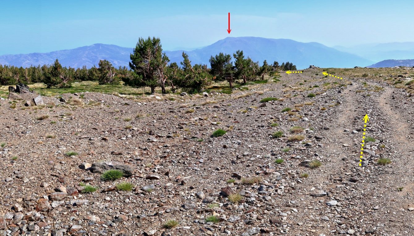
77) I won't take the bus. I'll walk to Puerto Molina along the unsealed road GR-411a.
- Upper pic: Yellow arrows: Direction of my walk
- Middle pic: Yellow arrows: Direction of my walk along GR-411a
- Lower pic:
• 3 red arrows, left to right:
1 Cerro de los Machos, 3329 meters
2 Pico de Loma Pelada, 3183 meters
3 Mulhacén, 3479 meters
• Yellow arrows: A good summary of my walk for the day :-)
• The route down the slope of Mulhacén is on its left side and further back. It can't be seen from here.

Scenery along GR-411a
I take the unsealed road GR-411a to Puerto Molina rather than walking on the mountain range as I did this morning.
78) 180-degree panorama while walking along GR-411a ... GR-411a is the unsealed road for shuttle buses.
- Upper pic: Facing backwards
• 3 red arrows, left to right:
1 Mulhacén, 3479 meters ... directly north
2 Alto del Chorrillo, 2721 meters
3 Rocky lookout at Mirador de Trevélez
• Yellow arrow on the left: Direction of walk along GR-411a
• Rest of the yellow arrows: Route in the morning to Mirador de Trevélez, Alto del Chorrillo, Mulhacén
- Middle pic: (Continuation to the right of the upper pic) East-ish
• 2 white arrows, left to right:
1 The town of Trevélez can't be seen from here. It is in the valley below the dark green patch.
2 Los Caballeros
- Lower pic: (Continuation to the right of the middle pic) Facing forward
• White oval: Cattle grazing ... Photo #79 zooms into this area.
• Yellow arrows: Direction of walk along GR-411a
• This morning, I walked on the mountain range to the right (west) of this pic.

79) Zooming into the white oval of previous pic ~~~
Cattle grazing on the slope

80) Along GR-411a ... scenery centred towards south ~~~
- Red arrow: Sierra de Lújar, 1878 meters ... towards south-south-west

Puerto Molina
Arrive at Puerto Molina.
I was here in the morning ... Refer to photos #5 and #6.
81) In the 4 pics below:
(1) • The information boards here are the ones in the cyan oval on the left of photo #5's lower pic.
• Red arrow: Sierra de Lújar, 1878 meters
• Yellow arrows: Direction of walk
(2) • Continuation to the right of (1)
• Same scene as photo #6's middle pic ... different time of the day hence different colour of the scene.
• Yellow arrow: Direction of walk
(3) Approaching the right side of (2)
(4) The far side of (3)

On the way to car
82) Shortly after leaving Puerto Molina ~~~
- Red arrow: Sierra de Lújar, 1878 meters
- Yellow arrows: Direction of walk
Not long after turning into the grove (left most yellow arrow of above pic), a laaarge flock of sheep pass me. In their midst is a huuuge white sheepdog. I've never seen a dog that big ! The dog stops by me, sniffs me up and down. It scares the shit out of me. If it decides to attack, no way I'm able to defend myself.
But the dog seems friendly enough. After it had a good sniff, it moves on with the sheep. Phew !
I didn't see any sheperd, just the dog. There are plenty of trees around. He is probabaly somewhere nearby. It is just that we can't see each other through the trees.
After that incident, I walk on and soon in the area of photo #2; then back at the car.
Nice walk ! Have a go at Mulhacén while you are in Spain.
ReplyDelete