2018 June: Day trip to climb:
- Mt Wolgan
- and the unnamed 870-meter hill west of it
in Gardens of Stone National Park, NSW, Australia
Prolog
On the web, there is hardly any detail about Mt Wolgan and the unnamed 870-meter hill west of it. So I decided to check out both peaks and write a trip report on them. As it turned out, I had to do the trip twice ... all because I didn't do any research on the first trip and couldn't find a way up the cliffs of Mt Wolgan.
- 1st trip: In 2018 May, with YM
- 2nd trip: This one, 2018 June, with AC
About the unnamed 870-meter hill
The story goes that the unnamed hill was supposed to be Mt Wolgan. However NSW Mapping Department wrongly placed "Mt Wolgan" label next to Donkey Mountain. So now this hill is unnamed, and the Mapping Department don't intend to fix it :-)
About Mt Wolgan
On the map, the west side of Donkey Mountain is now Mt Wolgan ... all due to the above mentioned error by NSW Mapping Department. Bushwalkers still regard it as part of Donkey Mountain. However, to be in sync with the maps, I'll call it Mt Wogan in this trip report.
On the current 2018 map, Mt Wolgan has two rocky hills:
- East side: Labelled as "The Columns" in Geoff Fox's sketch map.
- West side: This is the one AC and I are going to climb today.
Between the two hills is the saddle, GR 373 182. To climb the west side of Mt Wolgan, we need to reach the saddle first.
Note: In this trip report, I'll refer "Mt Wolgan" as the west side of the mountain (not the east side, "The Columns").
About Donkey Mountain
I've climbed Donkey Mountain a few times. Photos and trip reports are in my blogs:
- 1st trip: 29 months ago in 2016-01, to Mt Wolgan & west side of Donkey Mountain
http://mntviews.blogspot.com.au/2016/01/donkey-mountain-west-side-gardens-of.html
- 2nd trip: 27 months ago in 2016-03, to east side of Donkey Mountain
http://mntviews.blogspot.com.au/2016/03/donkey-mountain-north-east-maze-gardens.html
- 3rd trip: 22 months ago in 2016-08, to east side, with Geoff Fox leading
http://mntviews.blogspot.com/2016/08/donkey-mountain-north-east-maze-gardens.html
Maps
- 1:100,000 scaled 8931 Wallerawang
- 1:25,000 scaled 8931-4S Ben Bullen
- Plus Geoff Fox's sketch map ... He calls it "South West End Donkey Mountain". The map is in this link:
https://drive.google.com/file/d/1F1M70Joo5dimRxI-GMETQKeG8IVefnbi/view?usp=sharing
Below is the relevant part of the 1:25,000 scaled map.

GPS tracklog file & Route
The GPX tracklog file of our walk can be downloaded from:
https://drive.google.com/file/d/1zfVACTcRAbAfeTWSOmHegI-d5ntXDFE6/view?usp=sharing
Here is our tracklog, red colour, anti-clockwise circuit superimposed on the 1:25,000 map. (Click on the image to enlarge it.)
- Blue arrow at top of the map: GR 369 191 ... Small carpark by the south side of Wolgan Rd (Starting point of our walk)
- The 6 blue arrows near the bottom, from left to right:
1 Summit of unnamed 870-meter hill ... There is a cairn is at the summit.
2 Rocky outcrop #1
3 Rocky outcrop #2
4 End of "Top Slot" ... Refer to Geoff Fox's sketch map (left side of his map)
5 Top of "Easy Ramp" ... Refer to Geoff Fox's sketch map (left side of his map)
6 The saddle, GR 373 182 ... Between two rocky hills in Mt Wolgan
- Blue oval: "The Columns" in Geoff Fox's sketch map

Satellite view of our anti-clockwise circuit: (Click on the image to enlarge it.)
- Blue oval: "The Columns" in Geoff Fox's sketch map
- The saddle, GR 373 182, is between the rocky hill in the blue oval and the rocky hill to its west (left).

A summary of our route:
- Start at a small carpark by the south side of Wolgan Road
- To unnamed 870-meter hill west of Mt Wolgan
- To the saddle
- Climb Mt Wolgan from "Easy Ramp" in Geoff Fox's sketch map
- Back to carpark
Timeline & Distance
Park AC's car at Donkey Mountain access carpark, GR 369 191, by the south side of Wolgan Road.
08:33 0.0 km Start walking
09:20 1.75km Stop for morning tea
Morning tea
09:29 1.8 km Resume walking
09:38 2.05km At summit of unnamed 870-meter hill west of Mt Wolgan
09:42 2.1 km Start to go further west to check out whether there is any view
09:43 2.15km Still near the summit ... but as far west as we are willing to go
09:45 2.15km Turn around
09:48 2.25km Still near the summit ... at a large boulder whose top seems to be as high as the summit
Climb up the boulder
09:57 2.3 km Start to head to another large boulder to the north-east
09:58 2.35km Still near the summit ... at the large boulder
Climb up the Boulder
10:02 2.35km To Mt Wolgan
11:00 3.65km At rocky outcrop #1 at western tip of Mt Wolgan
11:07 3.65km Resume walking
11:14 3.75km At rocky outcrop #2 at western tip of Mt Wolgan
11:19 3.8 km Resume walking
11:23 3.9 km AC attempts to find a way up the cliffs
Wait for AC
He reports back that the cliffs are too steep to climb up
11:31 3.95km Resume walking
11:52 4.3 km Stop for lunch
Lunch
12:26 4.3 km Resume walking
12:28 4.35km At saddle point, GR 373 182 ... Refer to one of the above maps.
Turn south to walk along east side, then north side of the ledge under the upper-most cliffs of Mt Wolgan
12:33 4.55km At bottom of "Easy Ramp"; and start to climb up
12:38 4.55km At top of the ramp ... We are at the plateau at the top of Mt Wolgan !
Explore the plateau at the top of Mt Wolgan:
- First, we explore the east side of the plateau.
- Then explore the west side of the plateau.
- And investigate the inside of "Top Slot".
13:36 5.05km Back at the top of "Easy Ramp"; same spot as at 12:38
13:40 5.05km At bottom of "Easy Ramp"; same spot as at 12:33
13:44 5.25km At saddle point, GR 373 182; same spot as at 12:28
14:12 6.35km Back at the carpark
==============================================
Total: 5 hrs 39 mins
6.35km Distance is from Google Earth.
But Note: Route near Mt Wolgan is an idealized plotted route, not from GPS recording
8.2 km Distance is from Garmin GPS.
Pictures - Donkey Mountain access stile
1) Donkey Mountain access stile at a small carpark by the south side of Wolgan Road ~~~
The stile is used to cross a fence.
- Upper pic: The sign says:
Gardens of Stone National Park
Donkey Mountain Access
- Lower pic: AC is crossing the stile.

To unnamed 870-meter hill
2) Our first destination: Unnamed 870-meter hill west of Mt Wolgan
- Upper pic: View of the hill from the carpark
- Lower pic: While on our way towards it
It is off-track walking. As can be seen from the lower pic, the country is quite open, hardly any bushbashing involved.

3) Wombat holes on the way to the unnamed 870-meter hill

4) Passing an interesting boulder

5) On the slope of unnamed 870-meter hill ~~~
The slope is steep even though this photograph doesn't show it.

Summit of unnamed 870-meter hill
6) This is it ... summit of the unnamed 870-meter hill.
- Red arrow: The cairn at the summit

7) AC and I at the summit

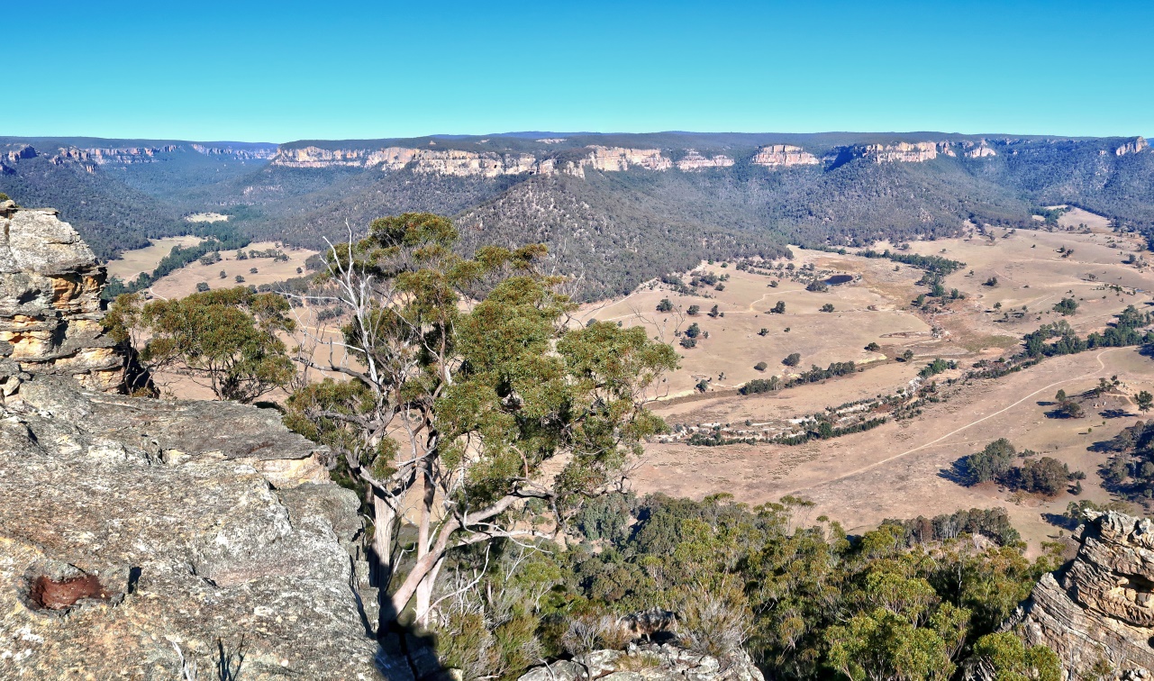
8) Today, not much can be seen from the summit as the valley below is filled with fog ... but still, it is a sight to behold ! The fog wouldn't linger for long. It will soon lift.
- Red arrows in both pics below: Point to same location ... towards north-west.
- The valley is where Barton Creek flows. Wolgan Road runs in there too, parallel to the creek.
- Lower pic: (Continuation to the right of the upper pic)

Western tip of the top of the unnamed hill
The top of the hill is a flat narrow plateau along the east-west axis.
We first go the western side of the plateau.
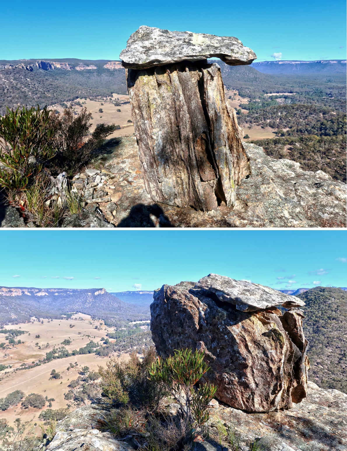
9) This large rock marks the western tip of the plateau.

10) From the western tip, looking back at the summit and its cairn

Eastern side of the top of the unnamed hill
Next, we go to the eastern side of the plateau.
11) The 2 pics below are of the same boulder. We are going to climb it.
- Upper pic: Go along the blue arrows to the other side of the boulder.
- Lower pic: We are at the other side of the boulder compared to the upper pic.
• Blue arrow: The way up is from the rock face behind this pic

12) Climbing up the boulder of the previous pic
- Yellow arrows: The way up
- Lower pic: AC is about to climb up.

13) Scenery of the plateau from the top of the boulder in the previous pic ~~~
- Red circle: We are going to climb this boulder next :-)

14) This is the boulder in the red circle of the previous pic ~~~
- Upper pic: We are going to climb to the top of this one.
- Lower pic: AC in action

To Mt Wolgan
We've done with the unnamed 870-meter hill ... now going to Mt Wolgan.
15) The story goes that the red-arrow peak below was supposed to be part of Donkey Mountain; and Mt Wolgan was supposed to be the unnamed 870-meter hill that we've just climbed. However NSW Mapping Department wrongly placed "Mt Wolgan" label at the red arrow. But bushwalkers still regard it as the west side of Donkey Mountain.
- Red arrow: For this trip report, I'll stick to the name on the map and call it Mt Wolgan. We are going to climb it now !
- Red slanting bar: Donkey Mountain
- Yellow arrow: Our route to Mt Wolgan.

West side of Mt Wolgan - scrambling up rocky slope
16) Plenty of scrambling up rocks when we are climbing up the western slope of Mt Wolgan.

West side of Mt Wolgan - rocky outcrop #1
17) We come to rocky outcrop #1. There is this interesting signature rock at the lookout.
- The 2 pics below are of the same rock ... from different angles.
18) The rocky outcrop mentioned in the previous pic has a 270-degree panorama centred at the unnamed 870-meter hill we've just climbed.
- Upper pic:
• Red arrow: Due west ... The unnamed 870-meter hill we climbed not too long ago.
- Lower pic: (Continuation to the right of upper pic)
• The valley across the pic (to the right of the 870-meter hill) is where Barton Creek flows. Wolgan Road runs in there too, parallel to the creek.

West side of Mt Wolgan - more rock scrambling
19) More rock climbing !
- Red circle: Refer to photo #20

20) This pic is the red circle of the previous pic.
- AC is taking a photo of me :-)
- Red circle: Rocky outcrop #2 (not the highest point of Mt Wolgan) ... We are climbing towards it now.

West side of Mt Wolgan - rocky outcrop #2
21) Climbing up to the red circle in the previous pic ~~~
- Photo taken in 2018 May ... YM is in action here.

22) Once we climb up (from the previous pic), we are at rocky outcrop #2, the red circle in photo #20.
- Upper pic:
• Small red circle: Small rocky platform ... We are going there now.
• Large red circle: The rock in photo #28
• Conical hill: Unnamed 870-meter hill we climbed not too long ago.
- Lower pic: Closer to the small red circle of the upper pic.

23) 2018 May trip ... YM and I standing on the rock platform in the small red circle of photo #22.

24) This trip ... AC and I

The scene from this lookout is similar to photo #18 at rocky outcrop #1.
25) This and photos #26 and #27 form a 270-degree panorama.
- Red oval: Emirates One&Only Wolgan Valley Resort ... Photo #68 zooms into the resort.

26) (Continuation to the right of previous pic)
- Red arrow: Cape Horn ... I was there 2 years ago in 2016. Trip report is in: http://mntviews.blogspot.com.au/2016/11/cape-horn-lawler-point-wolgan-state.html
- Conical hill in front of Cape Horn: Unnamed 870-meter hill we climbed not too long ago.

27) (Continuation to the right of previous pic)
- Yellow dot: Donkey Mountain carpark ... where AC's car is parked
- The valley across the pic is where Barton Creek flows. Wolgan Road runs in there too, parallel to the creek.

28) Still at the same lookout as the previous pics ~~~
This rock is the one in the large red circle of photo #22.

To the saddle
29) It is shortly after rocky outcrop #2 that we first face the vertical cliffs surrounding Mt Wolgan ... the top of which is where we want to climb up to. To get there, first we need to reach the saddle. (Refer to the maps at the beginning of this report.) To do so, walk around to the left side of this pic, then hug along the cliffs.
- Red oval: Before going around the cliffs, AC climbs up through here to investigate ... see photo #30.

After scrambling up the rocks, AC reports there is no way to climb up higher ...
30) ... So, he climbs back down.
Afterwards, we go around the cliffs on the left side of this pic.

31) We are now walking along the base the cliffs towards the saddle.
In 2018 May, YM and I went through the hole in the red oval. It is actually a tunnel ... see photo #32.

32) This is the tunnel in the red oval of the previous pic.
In 2018 May, YM and I went through it to investigate whether there might be a way to climb up the cliffs.

33) After going through the tunnel, we were confronted with a steep slope with loose stones. In this pic, YM climbed up to investigate. Unfortunately there was no way up. So we backtracked out of the tunnel.

34) In both the 2018 May trip and this trip, we continue to hug along the base of the cliffs towards the saddle.

35) The towering cliffs of Mt Wolgan ~~~
- This pic is taken not far from the previous pic.

36) In 2018 May, I climbed up the cliffs here to check whether there was any way to the top. Well, I reached a ledge further up the cliffs. But from there, it was not possible to climb even further up :-(
Photographer: YM
- Left pic: I was climbing up.
- Right pic: Climbing down

37) Hugging the cliffs towards the saddle ~~~
An interesting split of the cliff face.

The saddle
38) We are almost at the saddle.
- Upper pic: The saddle is just in front.
• To the left is east side of Mt Wolgan. In Geoff Fox's sketch map, it is labelled as "The Columns".
• To the right is west side of Mt Wolgan. We are going to climb to its top.
• Yellow arrows: Our route
- Lower pic: (Continuation to the right of the upper pic)
• The rocky hill here is west side of Mt Wolgan.

39) Similar to photo #38 ~~~
Now closer to the saddle
- Upper pic: The saddle is just in front.
• To the left is east side of Mt Wolgan. In Geoff Fox's sketch map, it is labelled as "The Columns".
• To the right is west side of Mt Wolgan. We are going to climb to its top.
• Yellow arrows: Our route
- Lower pic: (Continuation to the right of the upper pic)
• West side of Mt Wolgan ... We'll walk along the ledge to "Easy Ramp" in Geoff Fox's sketch map.

40) This is it, the saddle between the east and west sides of Mt Wolgan. Going further forward is down towards Emirates One&Only Wolgan Valley Resort.
We are not going forward. From here, we turn right towards the west side of Mt Wolgan.

41) Still at the saddle ... looking at the cliffs on the west side of Mt Wolgan.
- In 2018 May, from here, YM and I went to the left (south) side, to "Difficult climb" in Geoff Fox's sketch map ... Refer to photo #42.
- In this trip, AC and I will walk along the ledge (photo #39, lower pic) on the right side cliffs of this pic to "Easy Ramp" in Geoff Fox's sketch map.
- In photo #54, we'll be standing at the tip of the cliff top, looking down at here, the saddle.

2018 May - "Difficult climb"
42) As mentioned in the previous pic, in 2018 May, from the saddle, YM and I went to the south side cliffs and ended up here - "Difficult climb" in Geoff Fox's sketch map. (Photographer: YM)
- In the pic, I was attempting to climb up the cliff. It proved to be too steep for me and I gave up. But I'm sure a good rock climber should be able to climb up as there are plenty of hand and foot holds.

This trip - to "Easy Ramp"
43) This time we walk along the ledge on the north side of the cliffs.
The 2 pics below are taken around the same area:
- Upper pic: In the direction we are walking
- Lower pic: Looking back at AC who is at the centre of the pic
- Red ovals in both pics: They circle the same spot along the ledge.

44) We come to "Easy Ramp" in Geoff Fox's sketch map.

45) Now halfway up "Easy Ramp" and looking at the top of the ramp.

Looking down "Difficult climb"
46) We've climbed to the top of "Easy Ramp". A few steps forward and we are now standing at the top "Difficult climb". In photo #42, had I been successful in climbing up, I would be standing at this exact same spot.

Top of Mt Wolgan - east side plateau
47) The top of Mt Wolgan is a relatively flat plateau. After looking down the "Difficult climb" (previous pic), we go towards the east side of the plateau ... up the slope at the centre of this pic.
- Red oval: It is not so easy (slippery) to climb up the slope. So we put a log there to help us up :-)

48) After climbing up the slope with the assistance of the log (previous pic), we then climb up this rock cliff.
- Lower pic: Half way up the rock cliff

49) From top of the rocks of the previous pic, looking at where we are going next ~~~
- Red oval: "The Columns" in Geoff Fox's sketch map
- The 3 red arrows point to, from left to right:
1 East side of Donkey Mountain (left side of photo #51)
2 The tip of the cliff top in photo #41 ... We are going to there next.
3 Part of Donkey Mountain

50) Now standing at the cliff edge of the middle red arrow of the previous pic ~~~
- This pic is towards north. Together with photos #51 to #53, they almost form a 360-degree panorama.
- The tip of the cliff top in photo #41 is where I am standing now.

51) (Continuation to the right of previous pic)
The wonderful Donkey Mountain ~~~
Unless you use a drone, you won't get a better view of Donkey Mountain than from this vantage point.

52) (Continuation to the right of previous pic)
- The centre of this pic is towards south.
- Red oval: Emirates One&Only Wolgan Valley Resort ... south-west-ish ... Photo #68 zooms into the resort.

53) (Continuation to the right of previous pic)
- Left red arrow:
• Western tip of the plateau ... We'll be there ... Refer to photo #63.
• It is also the right red arrow in photo #61.
- Right red arrow: Left red arrow in photo #61.
- Continuation to the right of this pic is almost the left edge of photo #50 ... thus almost completing a 360-degree panorama.

54) Looking down at the saddle ~~~
- In photo #41, we were down below and looking up :-)

Top of Mt Wolgan - to west side plateau
55) We now go to the west side plateau.
- AC is sliding down the slope of photo #47. The log in the red oval of photo #47 is now at his feet.

Top of Mt Wolgan - west side plateau
56) Now at the west side of the plateau at the top of Mt Wolgan ~~~
- Red arrow: We are going towards the rock there.

57) AC climbs to the top of the rock (red arrow of previous pic).

58) My turn at the rock :-)

59) This pic together with photos #60 to #62 form a 360-degree panorama.
- Red arrow: Cape Horn, towards west ... I was there 2 years ago in 2016. Trip report is in: http://mntviews.blogspot.com.au/2016/11/cape-horn-lawler-point-wolgan-state.html
- Conical hill in front of Cape Horn: Unnamed 870-meter hill we climbed earlier on.

60) (Continuation to the right of previous pic)
- Upper pic:
• Yellow dot: Donkey Mountain carpark (towards north), where our car is parked
• The valley across the pic is where Barton Creek flows. Wolgan Road runs in there too, parallel to the creek.
- Lower pic: (Continuation to the right of the upper pic)
• Red arrow: Part of Donkey Mountain

61) (Continuation to the right of previous pic)
- Left red arrow: Part of the plateau on the western side of Mt Wolgan ... Compared to the right arrow it is not as high; and is closer to where we are standing now (even though in the pic, it looks further away).
- Right red arrow: Highest point on the plateau ... we are going there next.

62) (Continuation to the right of previous pic)
- Continuation to the right of this pic is photo #59, thus completing a 360-degree panorama.
63) This is the right red arrow in photo #61, and is the highest point on Mt Wolgan plateau ... about 950 meters.

64) Scenery from the top of the rock of previous pic ~~~
- This pic together with photos #65 to #67 form a 360-degree panorama.

65) (Continuation to the right of previous pic)
- Red arrow: Cape Horn, towards west ... I was there 2 years ago in 2016. Trip report is in: http://mntviews.blogspot.com.au/2016/11/cape-horn-lawler-point-wolgan-state.html
- Conical hill in front of Cape Horn: Unnamed 870-meter hill we climbed earlier on.
- Red circle: The rock we climbed in photos #57 and #58.

66) (Continuation to the right of previous pic) ... To enlarge the image, click on it.
- Red arrow: Donkey Mountain
- Red circle: Left red arrow in photo #61
- AC is on the left side of the pic.

67) (Continuation to the right of previous pic)
- Looking down at Emirates One&Only Wolgan Valley Resort ... Photo #68 zooms down at it.
- Continuation to the right of this pic is photo #64, thus completing a 360-degree panorama.

68) Zooming down at Emirates One&Only Wolgan Valley Resort ~~~
I don't understand Emirates rationale for building a resort here. It'll set you back a few thousand dollars a night staying in the resort ... But what for? The resort is in the middle of no where. Sure, there is the interesting Donkey Mountain nearby. But would a person willing to pay a few thousand dollars a night there, likely to want to climb Donkey Mountain?
- Lower pic: (Continuation to the right of the upper pic) Also part of the resort

69) Steam coming out of Mount Piper Power Station ~~~
- We saw it in photos #59, #64 ... etc.
- I've not seen this power station belching out steam like this before ... quite unusual.

"Top Slot"
70) Between the rocky lookouts in photos #57 and #63, there is a narrow slot, labelled in Geoff Fox's sketch map as "Top Slot".
- Left pic: I'm near the entrance of the slot looking down at AC climbing down.
- Right pic: We are inside the slot.

71) Out of "Top Slot" and now at an open area ~~~
- This pic is looking back at "Top Slot".
- The open area where I'm standing now doesn't have any place to go to ... cliffs on all sides. So we return into the slot and climb back up to the plateau.

This is it, the end of our trip.
Return to car
72) Time to go home :-) We make a beeline back to the car. While walking down the slope, I look back and take this picture of Mt Wolgan.

Comment
It is a pleasant short walk for the winter months.
No comments:
Post a Comment