2018 December: Climb Bimberi Peak & Mt Murray, ACT-NSW border, Australia
Day trip ... via Oldfields Hut
Prolog - List of named peaks in ACT above 1700 meters
I have compiled a list of named peaks in ACT above 1700 meters. There are 13 of them.
After today's climb to Bimberi Peak & Mt Murray, I have completed climbing all these 13 peaks ... YAY !!!
• 01 1913 m Bimberi Peak - Photos and trip reports are in my blogs:
- From east: 2011-01 http://mntviews.blogspot.com.au/2011/01/bimberi-act-australia-east-approach.html
- From west: 2009-12 http://mntviews.blogspot.com.au/2009/12/bimberi-act-australia.html
2018-12 This trip report (including climbing Mt Murray)
• 02 1855 m Mt Gingera - Photos and trip report are in my blog:
http://mntviews.blogspot.com.au/2013/01/mt-gingera-mt-ginini-act-australia.html
• 03 1845 m Mt Murray - This trip report
• 04 1829 m Mt Kelly - Photos and trip report are in my blog:
http://mntviews.blogspot.com.au/2015/01/kelly-burbidge-nsw-australia.html
• 05 1798 m Mt Scabby - Grid Ref 676 411
1805 m Unnamed peak just east of Mt Scabby - Grid Ref 681 410
Trip report is under construction.
• 06 1791 m Mt Namadgi - Photos and trip report are in my blog:
http://mntviews.blogspot.com.au/2015/10/mt-namadgi-act-australia.html
• 07 1766 m Ginger Ale - Grid Ref 601 586 (between Rolling Ground Gap & Blackfellows Gap)
Photos and trip report are in my blog:
http://mntviews.blogspot.com.au/2015/02/little-ginini-ginger-ale-act-australia.html
• 08 1762 m Mt Ginini - Photos and trip report are in my blog:
http://mntviews.blogspot.com.au/2013/01/mt-gingera-mt-ginini-act-australia.html
• 09 1739 m Mt Gudgenby - Photos and trip report are in my blog:
http://mntviews.blogspot.com.au/2017/11/mt-gudgenby-act-australia.html
• 10 1738 m Little Ginini - Photos and trip report are in my blog:
http://mntviews.blogspot.com.au/2015/02/little-ginini-ginger-ale-act-australia.html
• 11 1727 m Sentry Box Mountain eastern peak - Grid Ref 721 338
1696 m Sentry Box Mountain western peak - Grid Ref 714 338
1673 m Sentry Box Rock - Grid Ref 713 346
Photos and trip report are in my blog:
http://mntviews.blogspot.com.au/2015/11/sentry-box-act-australia.html
• 12 1724 m Mt Burbidge - Photos and trip report are in my blog:
http://mntviews.blogspot.com.au/2015/01/kelly-burbidge-nsw-australia.html
• 13 1711 m Mt Mavis - Grid Ref 722 493 (just north-east of Mt Namadgi; east of Big Creamy Flats)
Photos and trip report are in my blog:
http://mntviews.blogspot.com.au/2017/12/mt-mavis-act-australia.html
Data source:
- First, from LPI maps from Department of Lands
- Then from 1:50,000 scaled Rooftop's map called "Namadgi - ACT South Activities Map" 2011 edition
- Finally, in Google we trust :-)
Today's climb - Bimberi Peak & Mt Murray
Just the 2 of us: YM and I
- Bimberi Peak: Highest mountain in ACT, 1913 meters
I've climbed Bimberi Peak a few times. In the past, there wasn't any path to its summit. One simply bushbashed from Murrays Gap up its slope. It was quite an effort.
Nowadays, there is a foot track. It makes the climb so much easier.
Was the foot track built by National Parks and Wildlife Services ?
Or was it formed by the frequent tramping of us hikers ?
- Mt Murray: 3rd highest mountain in ACT, 1845 meters
As it is now easier to climb Bimberi Peak, hence there is enough time climb Mt Murray afterwards.
From a sign at Murrays Gap (scroll forward to photo #21), there is an indistinct foot track up its slope. And so it is quite easy to climb Mt Murray too.
There are 2 peaks at the top, about 500 meters apart.
- The peak on the west is the summit.
- The secondary peak is its east peak.
Maps
• 8626-1S Rendezvous Creek and 8626-4S Rules Point 1:25,000
• Rooftop's "Namadgi - ACT South Activities Map" 2011 edition; 1:50,000
• 8626 Tantangara 1:100,000
Below is the relevant part of the 1:25,000 scaled map: (To enlarge the image, click on it.)
- Pink arrow at bottom-left corner: A clearing on west side of Pocket Saddle Road for hikers to park their cars
- 3 blue arrows from top to bottom:
1 Murrays Gap, boundary of GR 625 497 and GR 625 498 ... There is a sign marking this spot; refer to photo #21.
2 Mt Murray east peak
3 Mt Murray summit

GPS tracklog file & route
The GPX tracklog file of our walk can be downloaded from:
https://drive.google.com/open?id=1iNmmQ2pMZx20iiw7IS07831TiQMVOl5G
Below is the 1:25,000 scaled map with our tracklog (in red) superimposed on it: (To enlarge the image, click on it.)
- Pink arrow at bottom-left corner: A clearing on west side of Pocket Saddle Road for hikers to park their cars
- 3 blue arrows from top to bottom:
1 Murrays Gap, boundary of GR 625 497 and GR 625 498 ... There is a sign marking this spot; refer to photo #21.
2 Mt Murray east peak
3 Mt Murray summit

Satellite view of our route in red:

In summary, our route is:
- Park car in a clearing on west side of Pocket Saddle Road, just in front of a locked gate.
- Walk northward on Pocket Saddle Road.
- 1.4 km later, turn east into Murray Gap Trail.
- Pass Oldfields Hut.
- Then to Murrays Gap.
- At Murrays Gap, turn north to Bimberi Peak summit.
- Afterwards, climb Mt Murray - west peak first, then its east peak.
- Climb down to Murrays Gap.
- Back to the car.
Timeline & Distance
Park YM's car in a clearing on west side of Pocket Saddle Road, just in front of a locked gate.
GR: 566 489, almost at 567 490
06:48 0.0 km Start walking
07:30 3.4 km At Oldfields Hut, boundary of GR 588 503 and GR 588 504
Take a look inside the hut
07:31 3.4 km Resume walking
08:31 7.7 km At Murrays Gap sign, boundary of GR 625 497 and GR 625 498 ... which is also the border of NSW-ACT
Morning tea
Nice sunny weather while we are having morning tea
08:42 7.75km Resume walking and start climbing up Bimberi slope
09:31 9.65km Stop
Put on rain jacket due to rain & thunder storm
09:40 9.7 km Resume walking
10:04 10.8 km At Bimberi Peak summit, 1913 meters
10:14 11.0 km Leave summit
11:13 14.0 km At Murrays Gap sign ... same spot as at 08:31
Lunch
Cloudy ... low clouds obscuring both Bimberi Peak & Mt Murray
We decide to go home ... If we climb Mt Murray, there won't be a view from its summit.
11:38 14.05km Start walking towards YM's car
12:09 15.8 km Turn around ... YM convinces me to climb Mt Murray as the sky is now 50% clear of clouds.
12:32 17.5 km Back at Murrays Gap sign
Rest
12:39 17.55km Start climbing up Mt Murray slope
13:31 18.7 km At Mt Murray summit, 1845 meters
13:40 18.75km Leave Mt Murray summit
13:57 19.25km At secondary peak of Mt Murray, its east peak, 1835 meters
14:02 19.3 km Leave Mt Murray east peak
14:57 20.65km At Murrays Gap sign again ... 4th time :-)
Rest
15:02 20.7 km Resume walking towards YM's car
15:58 25.05km At Oldfields Hut
16:39 28.45km At the car
==============================================
Total: 9 hrs 51 mins
28.45 km Distance is from Google Earth
It should have been 25 km and less than 9 hrs of walking, had it not for the clouds that made us wasting time by returning towards the car from Murrays Gap, then double back again (between 11:38 and 12:39).
Pictures: Wares Yards Campground - the night before
The night before, we stayed at Wares Yards campground.
If you come from Adaminaby:
- Drive along Snowy Mountains Highway for 19.4 km.
- Then turn right onto Tantangara Road.
- After approximately 7km along Tantangara Road, turn left into Wares Yards campground.
1) This is my tent. A drop-toilet is in the background.

I just noticed that Kmart is now selling a similar tent like this for only AU$12 ... Geez, that is cheap !
2) Plenty of kangaroos around the campground

At where the car is parked
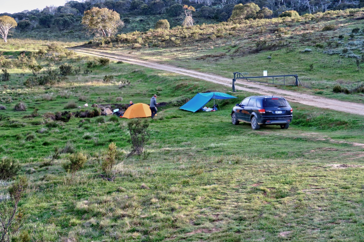
To climb Bimberi Peak and Mt Murray, cars are parked at a clearing on the west side of Pocket Saddle Road, in front of a lock gate and on the south side of Gurrangorambla Creek.
3) It is only 6:30am. Already, plenty of cars are here. Perhaps their owners are on multi-day hikes.
- Red circle: YM's car

4) Scenery around where the cars are parked (To enlarge the image, click on it.) ~~~
- The unsealed road on the right side of the pic is Pocket Saddle Road.
- Blue arrows: The way we'll soon be walking to climb Bimberi Peak
- Between the 2 blue arrows is a locked gate to prevent cars from venturing further on the road.
- The locked gate is where Pocket Saddle Road crosses Gurrangorambla Creek.
- (This photograph is taken in the afternoon after we finish our hike.)

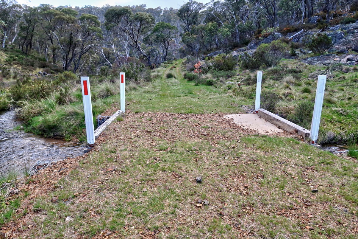
5) Zooming into the right side of previous pic
This is where Pocket Saddle Road crosses Gurrangorambla Creek ~~~
- (In contrast with the previous pic, this photograph is taken early in the morning.)
- Some people are camping here.
- A locked gate on the road prevents cars from venturing further.
Murray Gap Trail to Oldfields Hut
6) About 1.4 km (16 minutes for us) from the carpark, we arrive at a junction where we turn right (east) into Murray Gap Trail.
- Upper pic: Sign at the junction of Pocket Saddle Road and Murray Gap Trail
- Lower pic: YM on Murray Gap Trail

Oldfields Hut
7) Another 2 km (26 minutes for us) from the junction of photo #6, we arrive at Oldfields Hut, boundary of GR 588 503 and GR 588 504.
- Upper pic: Photograph taken in the morning
- Lower pic: Taken in the afternoon on the return leg, hence the difference in colour
• This pic and the 3 pics in photo #8 form a 360-degree panorama.
- Yellow arrows: Direction of our walk to Murrays Gap
- A closer look at Oldfields Hut is in photo #11.

8) Panorama from Oldfields Hut ~~~
- Upper pic: (Continuation to the right of previous pic)
• Red arrow: Bimberi Peak
- Middle pic: (Continuation to the right of the upper pic)
• 2 red arrows from left to right:
1 1484-meter unnamed hill ... Behind the hill is Murrays Gap.
2 Mt Murray,
- Lower pic: (Continuation to the right of the Middle pic)
• YM
- Continuation to the right of the lower pic is photo #7's lower pic, thus completing a 360-degree panorama.

9) From Oldfieds Hut we can see where we'll be going for the rest of the day: (To enlarge the image, click on it.)
- 3 red arrows from left to right:
1 Bimberi Peak ... Going to climb it now
2 1484-meter unnamed hill ... Behind the hill is Murrays Gap.
3 Mt Murray ... Will be climbing it after summiting Bimberi Peak
- Yellow arrows: Our route:
- First, head for Murrays Gap.
- Then climb Bimberi Peak.
- Then climb Mt Murray.

10) The previous pic is taken in the afternoon on the return leg.
By contrast, this pic of Bimberi Peak is taken in the morning at 7:30am.
Storm clouds are heading our way :-(

11) A closer look at Oldfields Hut

12) Fire place in front of Oldfields Hut

13) Inside Oldfields Hut ~~~
- Someone must have lit a huge fire once.
- And someone has written the words "SMALL FIRES ONLY PLEASE" on the mantelpiece ... haha !

14) Drop-toilet

Goodradigbee River
Shortly after Oldfields Hut, we cross Goodradigbee River which flows north into Murrumbidgee River.
(The confluence of Goodradigbee River and Murrumbidgee River is at Burrinjuck Dam.)
15) Bridge over Goodradigbee River ~~~
The bridge was built in 2009. Prior to that, you maybe able to jump across the river if there hadn't been too much rain in the preceding days.
16) Goodradigbee River ~~~
- Upper pic: Downstream ... north-ish
- Lower pic: Upstream ... south-ish

Murray Gap Trail to Murrays Gap
17) YM passing the first locked gate on Murray Gap Trail

18) Scenery along Murray Gap Trail ~~~ (To enlarge the image, click on it.)
- Yellow arrows: Trail to Murrays Gap ... We are walking towards there.
- Left red arrow: Bimberi Peak ... The summit itself is somewhere behind and can't be seen from here.
- Right red arrow: Mt Murray

19) YM about to pass a second locked gate on Murray Gap Trail

Murrays Gap
20) We are at the swamp of Murrays Gap ~~~
- Yellow dot: There is a sign marking Murrays Gap. It is also the border of NSW & ACT. Refer to photo #21.
- 2 red arrows from left to right: (We'll climb both peaks after summiting Bimberi Peak.)
1 Mt Murray secondary peak (east peak)
2 Mt Murray summit (west peak)

21) YM and I at Murrays Gap, boundary of GR 625 497 and GR 625 498 ... which is also the border of NSW & ACT
- On the near side of the sign is Kosciuszko National Park in NSW.
- On the far side is Nadmadgi National Park in ACT.
- We have morning tea here.

22) From Murrays Gap sign, looking across the swamp ~~~ (To enlarge the image, click on it.)
- Yellow arrows: We walked on the firetrail through the swamp to where we are now.

23) Zooming into the right half of previous pic ~~~
- Yellow square: We'll go there shortly to climb up the slope of Bimberi Peak.
- In fact, another group of bushwalkers are already there ... Refer to the lower pic.

Climb up Bimberi slope
I have climbed Bimberi Peak a few times in the past. The latest was almost 8 years ago in January 2011.
In those days, There was no path up the slope. There were some cairns here and there. But you would be hard pressed to find them amongst the scrubs. And so, you just bushbashed all the way up. Navigation-wise it wasn't too hard. Use a compass and just head north. But ...
24) ... But today, there is a foot track. It makes the climb so much easier !
- Upper pic:
• Was the foot track built by National Parks and Wildlife Services ?
Or was it formed by the frequent tramping of us hikers ?
• Cyan arrow: Just so that you won't lose the path, there are plenty of red ribbons along the track.
- Lower pic: And plenty of cairns too

25) A sample of the foot track up Bimberi slope ... Without the need to bushbash, the climb is so much easier now.

26) At this time of the year, plenty of Oxylobium ellipticum (Common Shaggy Pea) throughout the slope of Bimberi Peak.

27) Found this Olearia brevipedunculata (Dusty Daisy-bush) ~~~
Identification by anonymous in the Comment Section.

28) Found this Stackhousia monogyna (Creamy Stackhousia, Creamy Candles) ~~~
Identification by anonymous in the Comment Section.

Thunderstorm
Weather forecast was for showers at 6am. Then clear up by 9am.
But the forecast was off by 3 hours. Around 9am rain and thunderstorm came. The sky will only start to clear by 12 noon.
29) Not long ago, we overtook a bunch of hikers ... The same group as in the lower pic of photo #23.
Then a thunderstorm came along.
In this pic, the hikers are passing us by as we stop to put on rain jackets, and wait for the storm to pass away.

To the summit of Bimberi Peak
The thunder storm had passed away.
30) We are now at the flatter part of Bimberi slope and heading north-west.
In the pic, YM has a yellow rain cover over his backpack.

31) Eucalyptus pauciflora, commonly known as snow gum ... It is a beautiful tree.

32) A tree burr ... It looks like a skull :-)

33) We are close to the summit of Bimberi Peak .... We can see the trig at the summit.

Summit of Bimberi Peak - 1913 meters
34) This is it, the summit of Bimberi Peak.

35) YM and I at the summit, 1913 meters, Yay !

36) This and the 3 pics in photo #37 form a 360-degree panorama from the summit of Bimberi Peak.
- Red arrow: Ginger Ale
- White square: The pattern on the rock has some resemblance to a man's face :-)

37) Panorama from the summit of Bimberi Peak ~~~
- Upper pic: (Continuation to the right of previous pic)
• Blue arrow: Corin Dam
• 6 red arrows from left to right:
1 Ginger Ale
2 Unnamed 1847-meter peak north-west of Mt Gingera summit
3 Mt Gingera ... towards north
4 Tidbinbilla Mountain
5 Tidbinbilla Peak (Tidbinbilla Mountain & Tidbinbilla Peak are 2 separate peaks.)
6 Mt Tennent ... east-north-east
• Mt Ginini is behind Mt Gingera and can't be seen from here.
- Middle pic: (Continuation to the right of the upper pic)
• 9 red arrows from left to right:
1 Mt Tennent ... east-north-east
2 Tinderry Twin, the very distant mountain
3 Tinderry Peak, the very distant mountain
4 Mt Mavis
5 Mt Namadgi
6 Mt Burbidge
7 Mt Kelly ... south-east
8 Mt Gudgenby
9 Mt Scabby
- Lower pic: (Continuation to the right of the middle pic)
• 4 red arrows from left to right:
1 Mt Murray east peak
2 Mt Murray west peak, the summit ... towards south
3 Mt Morgan
4 Half Moon Peak
• Cyan-coloured thingie near bottom right corner: My backpack in a rain cover
- After today, except for Mt Morgan & Half Moon Peak, I'll have climbed all these peaks, Yay ! :-)
- Continuation to the right of the lower pic is photo #36, thus completing a 360-degree panorama.

38) Zooming into Corin Dam, blue arrow in photo #37 ~~~
Corin Dam, together with Bendora Dam (downstream) and Cotter Dam (further downstream) form the main water supply for Canberra.

Back at Murrays Gap
After climbing Bimberi Peak, we retrace our steps back to Murrays Gap.
39) A wild pig is seen at the same spot as the lower pic of photo #23 ... ie where we started the climb up the slope of Bimberi Peak.

We had intended to climb Mt Murray now. But at this time, its peak is shrouded in clouds. And so we call it a day and head back to the car.
Half an hour down the track, YM notices the sky has cleared and Mt Murray is no longer in the clouds. I'm not keen to climb Mt Murray then ... my boots are wet from the thunderstorm, and we are already 2 km down the track towards the car.
But YM puts up a good argument ... if we are here on any other day, blue sky with some high white clouds, we would have gone on to climb Mt Murray instead of heading the other way.
He is right. So we turn around, back to Murrays Gap sign of photo #21 :-)
Climb Mt Murray
40) Now climbing up the slope of Mt Murray ~~~
- There is an indistinct foot track ... probably formed by the tramping of us hikers. The foot track peters out when closer to the summit.

41) Typical scenes of the slope of Mt Murray

42) Close to the summit of Mt Murray now

43) Almost at the summit .... just in front

Mt Murray summit - 1845 meters
44) This pile of boulders is the summit of Mt Murray.

45) YM and I at the summit of Mt Murray, 1845 meters ... Yay !
- In both the 2 pics below, Bimberi Peak is blocked by the shrub on the right half of the pics.
- Lower pic: This and the 3 pics in photo #46 form a 360-degree panorama from the summit of Mt Murray.

46) Scenery from the summit of Mt Murray is not too good ... The area is too flat and too many trees around :-(
- Upper pic: (Continuation to the right of previous pic)
• Yellow arrow: Mt Murray east peak ... We are going there next.
• 7 red arrows from left to right:
1 Mt Tennent
2 Mt Mavis ... It is there, even though one can hardly see it :-)
3 Tinderry Twin ... due east
4 Tinderry Peak
5 Mt Namadgi
6 Mt Burbidge
7 Mt Kelly
• Photo #47 zooms into the right half of this pic.
- Middle pic: (Continuation to the right of the upper pic)
• 2 red arrows from left to right:
1 Mt Gudgenby
2 Yaouk Peak
• Red bar: Mt Morgan & Half Moon Peak are there (towards south-ish), blocked by the trees.
- Lower pic: (Continuation to the right of the middle pic)
• Red oval: Tantangara Reservoir
- Continuation to the right of the lower pic is photo #45, thus completing a 360-degree panorama.

47) Zooming into the right half of the upper pic of photo #46 ~~~
- Yellow arrow: Mt Murray east peak ... We are going there next.
- 7 red arrows from left to right:
1 Mt Mavis ... It is there, even though one can hardly see it :-)
2 Tinderry Twin ... due east
3 Tinderry Peak
4 Mt Namadgi
5 Mt Burbidge
6 Mt Kelly
7 Mt Gudgenby

48) As mentioned in photo #45, you can't see Bimberi Peak from the summit, blocked by some shrubs. But if you step away from the summit, you can see it.
- Red arrow: The summit of Bimberi Peak
- Yellow arrows: The route to the summit.

Mt Murray east peak - 1835 meters
Next we head towards the east peak of Mt Murray ... about 500 meters to the east of the summit.
49) The top of Mt Murray east peak is somewhere amongst these boulders.

50) East peak of Mt Murray is just in front.
- We'll go around to the right side of these boulders, then climb up.

51) YM on the final climb to the top of the east peak of Mt Murray

52) We are at the top of the east peak of Mt Murray.
- Upper pic: YM ... Bimberi Peak is in the background.
- Lower pic: Me ... Red arrow: Half Moon Peak

53) Facing Mt Murray summit ~~~
- This pic and photo #54 form a 360-degree panorama.

54) Panorama from the top of Mt Murray east peak ~~~
- Upper pic: (Continuation to the right of previous pic)
• 3 red arrows from left to right:
1 Bimberi Peak ... we were there this morning.
2 Tidbinbilla Mountain
3 Tidbinbilla Peak (Tidbinbilla Mountain & Tidbinbilla Peak are 2 separate peaks.)
• Yellow arrows: The route to climb Bimberi Peak.
- Middle pic: (Continuation to the right of the upper pic)
• 5 red arrows from left to right:
1 Mt Tennent
2 Mt Mavis
3 Tinderry Twin ... due east
4 Tinderry Peak
5 Mt Namadgi
• Red circle: This pile of boulders looks as high as where we are standing now.
(We won't be climbing it. It is getting late and we have a long way to drive back to Sydney tonight.)
- Lower pic: (Continuation to the right of the middle pic)
• 6 red arrows from left to right:
1 Mt Scabby west peak
2 Sentry Box Mountain east peak
3 Sentry Box Mountain west peak
4 Yaouk Peak
5 Mt Morgan
6 Half Moon Peak
• Red oval: Boulder at top of Mt Murray east peak ... Refer to lower pic of photo #52.
- Continuation to the right of the lower pic is photo #53, thus completing a 360-degree panorama.

Swamp at Murrays Gap
We've climbed down Mt Murray.
55) During the descent we had intended to aim for the Murrays Gap sign of photo #21. But our navigation was a bit off and we ended up 200 meters east of the sign :-)
- Upper pic: Mt Murray ... We just came down from there.
- Lower pic: (Continuation to the right of the upper pic) Towards west-ish
• Yellow arrow: Direction of our walk back to the car
• Yellow dot: Murray Gap sign of photo #21 is just behind the scrubs there.

56) Near where the previous pic was taken, and facing east-ish ~~~
- 3 red arrows from left to right:
1 Mt Namadgi
2 Unnamed 1721-meter peak
3 Mt Kelly

57) Water in the swamp (near where the previous pic was taken)

Then it is back to the car.
Hasn't changed in 20 years. Our walk was lunch in Cooma, then I think we had to walk further but had the night at Oldfields HUT, then had a jaywalk to Bimberi, walked out the next day and lunch in Cooma.
ReplyDeleteCompared to 20 years ago, there is now a foot track from base of Bimberi to the top, making the walk so much easier.
DeleteAlso Murray Gap Trail has 2 new bridges over the creeks ... meant for the fire trucks to have easier access in case of bushfire.
Other than that, not much has changed. Oldfields Hut is till the same.
Plant Names:
ReplyDelete1, Dusty Daisybush, Olearia brevipedunculata
2, Creamy Candles, Stackhousia monogyna
Thank you !
DeleteI have updated the blog accordingly.