2024-December
Day-trip ... bushwalk to:
a Gerringong Creek waterfall ...
Unofficially known as
Pensions Falls
by the Shoalhaven Bushwalkers club
Budderoo National Park, NSW
PDF version
If you prefer ...
A slightly shorter PDF report of the trip is in
this link:
https://drive.google.com/file/d/1PBi0PtSoOgzra8nhAM7tRmL3B8Du7Kgr/view
Otherwise, read on ...
Preview
a Gerringong Creek waterfall
Pensions Falls ... unofficially name

Topographic map & location
NSW 1:25,000 scaled 9028-4S Kangaroo Valley
(Scroll forward to see the map.)
Grid Ref: 2842 6060
The waterfall is the next main fall
downstream (south) of Gerringong Falls.
Prolog
A group of hikers went there
in early September 2024
and refused to reveal its location.
Why the secrecy ?
The group kept mum about the reason too.
So, the reason for the secrecy is also a secret !
The group posted their bushwalk in these 2 links:
https://www.instagram.com/p/C_sHeHdBBBM/
https://www.facebook.com/reel/1268811994303420
And claimed it took them
25 km and 11 hours
for the entire trip,
with a tough bushbashing component.
If so, then no Instagrammer nor TikToker
would go there to disturb its serenity.
Then, why the secrecy ???
The locals know about this waterfall,
and hikers in Shoalhaven Bushwalkers Club
go there regularly.
Hence sooner or later
we would all find out its location.
As the secrecy can't be kept for long,
it just makes the group's paranoid
look really puerile !
By the way, I’m not a waterfall chaser.
If someone shows me an interesting waterfall,
it goes into my bucket list,
and may just stay there forever.
However, as this waterfall is meant to be secret,
hence it became a challenge to find its location.
And when Jeremy said he knew where it is,
and offered to take a group there,
I put up my hand straight away !
Our group
5 of us:
Jeremy (Fodor ?) - leader
Amy Chi
John Graham
Lyndal Tegel
Paul
Topographic map & route
Map: NSW 1:25,000 scaled
9028-4S Kangaroo Valley
- 2 red arrows, left to right:
1 Grid Ref 8182 5924
Park car here on Gerringong Creek Rd,
just outside Winderong Farm.
2 Grid Ref 2842 6060 ... The waterfall.
(The next main fall downstream (south)
of Gerringong Falls)
- Blue arrows: Route to the waterfall.
Simply walk upstream,
along Gerringong Creek.

Pensions Falls - its unofficial name
The waterfall is not named in the above map.
But the Shoalhaven Bushwalkers Club
gave it an unofficial name
Pensions Falls
after the previous owner of a land
near the waterfall.
To reach the trailhead
At the town of Kangaroo Valley,
take Upper Kangaroo River Road,
then drive along Gerringong Creek Rd (unsealed).
When you reach a sign that says something like:
"Private Property, No Access"
Park outside the property.
(You've reached the entrance of Winderong Farm.)
In other words, you've reached the trailhead.
Grid Ref 8182 5924.
To reach the waterfall
The bushwalk starts by
scrambling down to Gerringong Creek,
then simply walk upstream (north-east-ish)
towards the waterfall.
Return leg is to retrace the steps.
Gerringong creek is NSW crown land,
not in private property,
hence no problem for hikers to walk along it.
Reference on the creek being crown land:
https://bushwalk.com/forum/viewtopic.php?f=36&t=41799
When in website, scroll forward a bit
to find the info.
(Note: Near where you park your car,
there are private properties
on both sides of Gerringong Creek.
But Gerringong Creek itself is crown land.)
It takes us 3 hours of walking, one way,
to reach the waterfall.
The group who kept the fall a secret
They went there in early September 2024
and took a different,
and an unnecessarily torturous route.
They parked their car at the usual carpark
for Gerringong Falls.
They then walked on a loooong firetrail.
Then somehow bushbashed their way to the fall.
That explained their 25 km, 11 hours trip.
Timeline & Distances
Park Lyndal's car at trailhead.
Grid Ref: 8182 5924
07:57 0.00km Start walking
09:20 2.63km At 1st set of cascades
Grid Ref 8381 6019
Morning Tea
09:35 2.7 km Resume walking
10:16 3.26km At bottom of 2nd set of cascades
Grid Ref 8413 6046
10:28 3.36km Leave top of the cascades
10:36 3.48km At waterfall
Lunch
12:13 4.35km Leave waterfall
12:17 4.46km At top of 2nd set of cascades
12:33 4.7 km Leave bottom of
2nd set of cascades
13:00 5.28km At 1st set of cascades
13:16 5.44km Leave 1st set of cascades
14:37 8.23km Back at Lyndal's car
Total:
6 hours 40 minutes
8.23 km Distance is from Google Earth.
Pictures - Gerringong Creek
1) Gerringong Creek.
- The entire trip is walking along this creek.

2) Asplenium nidus (epiphytic Bird's Nest Fern).
A remarkable feature of this creek is
plenty of this plant along the creek banks.
Photo by John

3) Asplenium nidus (epiphytic Bird's Nest Fern).

4) Gerringong Creek.
- Left to right: Jeremy, John

5) Gerringong Creek.
- Left to right: Jeremy, John, Amy

6) Asplenium nidus (epiphytic Bird's Nest Fern).
(On a fallen log)
- Plenty of this plant along the creek.

7) Zooming to the
Asplenium nidus (epiphytic Bird's Nest Fern).

1st set of cascades in Gerringong Creek
Grid Ref: 8381 6019
8) 1st set of cascades in Gerringong Creek.
- John ... on the right edge

9) 1st set of cascades.
The upper part of previous pic.
- Clockwise from centre:
Amy, Lyndal, Jeremy, John

10) We take a rest at the cascades.
- Amy finds a swing.

11) Amy swinging ... She is a bundle of fun.

12) A little upstream of the cascades area.
- Jeremy

13) Zooming to the right part of previous pic.

More of Gerringong Creek
14) Keep walking upstream.
- Amy, Lyndal

15) Gerringong Creek.
- Amy, John, Lyndal

2nd set of cascades
Grid Ref: 8413 6046
16) We are close to our destination now ...
It is the waterfall in the distance (white arrow).
- Lyndal, Amy, Jeremy, John
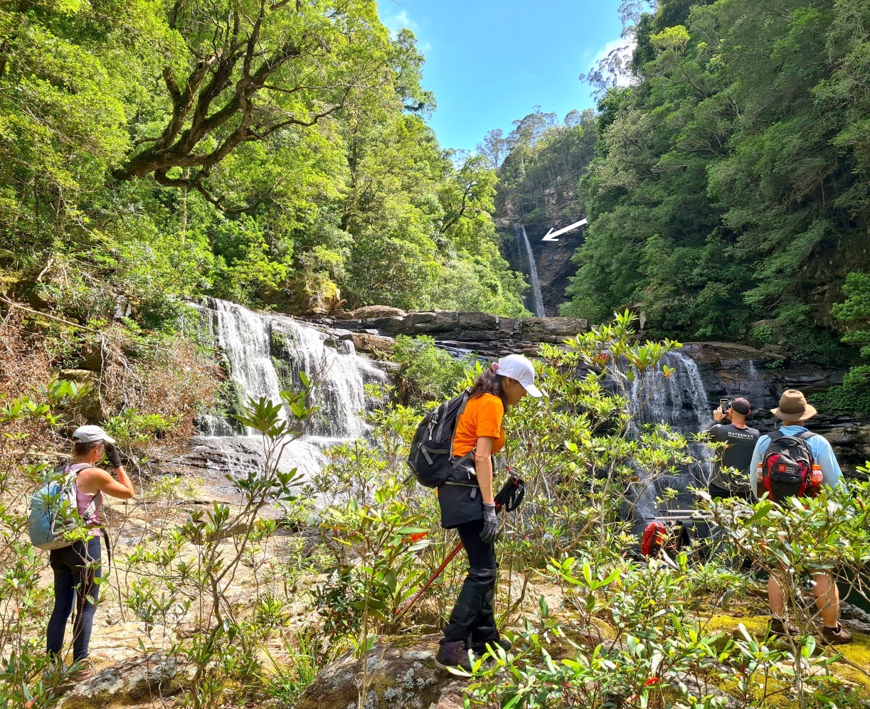
17) Nice cascades !
- White arrow: The waterfall we are heading to

18) Climbing up to
above the cascades of previous pic.
- Lyndal ... (John in front of her)

19) Above the cascades of photo #17.
- Left to right: John, Lyndal, Amy

20) A nice view of us above the cascades.
- The waterfall is in the background.
- Clockwise from left:
Lyndal, Amy (lying down), Paul, John, Jeremy
Photo by John

21) Zooming to us.
- Clockwise from left:
Lyndal, Amy, Paul, John, Jeremy
Photo by John

22) The edge of the cascades.
- Amy

23) The edge of the cascades and the pool below.
- Lyndal, Amy

24) The edge of the cascades and the pool below.
- Lyndal

To the waterfall
25) Heading to the waterfall now.

26) Walking along Gerringong Creek
to the waterfall.
- Lyndal, John

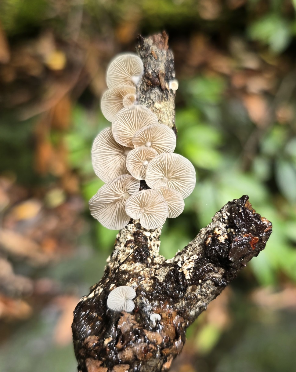
27) Mushrooms.
Photo by John
28) This trip, we’ll only go to the
bottom of the main waterfall.
Next time, we should climb further up 😊
Photo by John

29) This trip, we’ll only go to the
bottom of the main waterfall.
Next time, we should climb further up 😊
Photo by John

30) Going to the bottom of the waterfall now.
Photo by John

The waterfall
31) We reach the waterfall.
After about 3 hours of walking.

32) The waterfall and its plunge pool.

33) Amy.

34) Amy.

35) Amy, Lyndal.
- White arrow: John swimming

36) Walking to the base of the waterfall.
- Amy, Lyndal
- The rest of us are happy to take photographs
of them venturing there.

37) It gets slippery further towards the waterfall.
- Hence only Amy (near right edge)
is going there now.

38) Zooming to Amy.

39) Amy ... She doggedly keeps going.

40) Amy makes it to the waterfall.

41) This is as far as Amy is willing to go.

42) Zooming out of the previous pic.
- Amy
43) Swimming in the plunge pool.
- Amy

44) Swimming.
- Amy, Lyndal, John

45) Swimming.
- Amy, Lyndal, John

46) Standing on a submerged rock.
- Amy

47) Standing on a submerged rock.
- Zooming to Amy

48) Standing on the submerged rock.
- John & Lyndal’s turn

49) Zooming to John & Lyndal.

50) Standing on the submerged rock.
- Clockwise from left: John, Lyndal, Jeremy, Amy.

51) Zooming in.
- Clockwise from left: John, Lyndal, Jeremy, Amy.

52) Me and the pretty girls.
- Amy, Paul, Lyndal
Photo by John

53) The boys ... John, Jeremy, Paul.
Photo by Lyndal

54) The pretty girls ... Amy, Lyndal.

55) Lyndal.
Photo by John

Edge of the pool
56) Megadolomedes australianus
(Giant Water Spider).
Just so that there is no misunderstanding,
the giant spider is not me ... ok 😊
Photo by John

57) At the water edge.
- Megadolomedes australianus
(Giant Water Spider).

58) The edge of the plunge pool.
- Amy ... Relaxing

59) Zooming in.
- Amy ... Relaxing by the edge of the pool.

Return to our cars
60) The banks of Gerringong Creek.
- We are retracing our steps back to the cars.

61) Thopha saccata (Double Drummer Cicada).
Found by Jeremy.
- Reputedly the loudest insect in the world !

62) The banks of Gerringong Creek.
- Amy.
She has a knack of finding vines to swing on 😊

Back at 1st set of cascades
63) Looking down at the cascades of
photos #8 - #11.
- Lyndal, Amy

64) The same cascades as previous pic.
- Jeremy

65) Scene here is identical to photo #9.
- Jeremy

66) Jeremy, Amy.

67) Same vine as in photos #10 - #11.
- Amy ... swinging

68) Amy ... She is a swinger 😊

69) Lyndal.

70) I am a converted swinger now 😊
Photo by John

71) Diphlebia lestoides (Whitewater Rockmaster).
A species of Australian damselfly
in the family Lestoideidae.
- Red ovals: Note the white bands across its wings.

72) Trailhead ... just outside Winderong Farm.
- Some construction is going on.
- By the time you come here,
the place may look different.

Comments
1)
Quite an interesting waterfall.
Not hard to get to.
A good pool at the bottom
for a swim or skinny-dip,
as hardly anyone would go there to disturb you.
2)
If I go there again,
I would try to check out the top of the waterfall.
Hi Paul, look at the drone photos 28 - 30, from bottom to top of the main fall would be as difficult as climbing up and down the real Gerringong Falls with sheer cliff walls all around. Did you see any easier sections beyond the reach of lens to ascend to the top of cliff? I'm thinking of bashing downstreams from Budderoo.
ReplyDeleteIf you are at the top of the fall, and you wish to get down to the bottom of the fall, you would have to bushbash a fair amount of distance ... eventually there will be a way down to the creek.
DeleteYou would have to bushbash to below the "2nd set of cascades", photo #16.
Delete